
| |
| Volume 3, Number 5 | September/October 1997 |
William G. Dever[1]: Most Biblical scholars regard most of the stories in Genesis as myths.
…
Hershel Shanks[2]: It's true, I think, that the first 11 chapters of Genesis would be regarded as myths—the creation stories, the story of Noah and the flood …[3]
For the past several months I have been deeply immersed in an investigation of the physical cause of Noah's Flood. Nearly all else has been swept from my world as I have pursued this long-kept mystery—a fact which explains both the unusual, monolithic nature of this present issue of The Biblical Chronologist, and the small, stratified mound of correspondence in one corner of my office waiting silently, patiently, for excavation to begin.
As I now set about to communicate what I have found I am aware of several limitations. For one thing, my quest is not entirely complete. I would have liked several more weeks to tie up a few loose ends. But the publication deadline for this issue presses—I have already put it off longer than is strictly permissable. In consequence, you will need to regard the present article as an interim report on research still in progress rather than a final product.
How can I explain the other limitations I feel? I feel as if I have been tunneling through a previously impassible mountain range. I have been at it with pick and shovel for quite a spell. I have just now broken through the far side with my pick—daylight streams through a ragged hole. It is too small to squeeze through, but as I gaze about through it I see a bright, bounteous, unexplored country. Its features are foreign and some are wholly unexpected…. But I must go back. I have an appointment with my friends back at the entrance to the tunnel on the other side of the mountain and I must not be late. I must tell them what I have seen. I must bring them here. Will I be able to satisfy all of their questions? Will they be able to follow me back through the dark tunnels?
Should we look for a physical cause of the Flood? Isn't it somewhat impious to do so?
Yes, we should look for a physical cause of the Flood, and no, it is not impious to do so. In point of fact, given the present climate of rampant unbelief of the Bible among learned men and women world-wide, it is impious for Christians not to do so. Let me explain.
Genesis does not represent the Flood of Noah as a mythical saga. It presents it as sober, real-life history. So when a man or a woman concludes that Noah's Flood is mythological, they have automatically also concluded that Genesis is not a reliable historical witness. But if the Bible's historical witness in Genesis cannot be trusted, what basis is there for supposing that its historical witness in the Gospel of John can be trusted? If the Bible says the Flood happened when in fact it never did, should we trust the Bible when it says the Resurrection happened?
It will not help to try to separate the Old Testament from the New either, as if the Old could be mistaken but the New still sound, for the New Testament also treats the Flood as real-life history. It reads, "And just as it happened in the days of Noah, so it shall be also in the days of the Son of Man: they were eating, they were drinking, they were marrying, they were being given in marriage, until the day that Noah entered into the ark, and the flood came and destroyed them all."[4]
If Noah's Flood is myth, then the New Testament as well as the Old cannot be trusted. Indeed, in that case, even Christ cannot be trusted (may it never be!) for those are His words which we have just read above from Luke 17. He has then Himself mistaken a myth for real history. And how then can men and women be called to trust Him—to rest their eternal destiny in Him?
Is it not then the pious duty of every genuine Christian to exert themselves in whatever way they are able to show the historical factuality of Noah's Flood to the present, unbelieving generation?
As it turns out, there is no better way of doing this then by discovering the physical cause of the Flood. I will not try to explain why this is so here; it will, I hope, be abundantly clear by the time you have finished reading this article.
But I do not want my attempt to find the physical cause of the Flood to be misunderstood. I am a scientist and I will be bringing the tools of science to bear on this question as forcefully as I know how. But please do not suppose for even a moment that I am out to purge the Flood narrative of the supernatural by my effort to understand its physical cause. The Biblical narrative clearly portrays supernatural activity associated with the Flood, and I have no argument with the witness of the text. (Neither, for that matter, does true science, though many today, having imbibed deeply of the philosophical intoxicant called naturalism, would have us believe otherwise.) The timing of the Flood was clearly supernatural. The revelation of the impending judgment to Noah was clearly supernatural. Even the closing of the door of the ark was supernatural.[5] It would be folly, in my opinion, and a denial of the word of God to attempt to find a natural, physical cause underlying any of these things.
But the Flood narrative also involves much which is not supernatural. God could have supernaturally taken Noah, his family, and the animals out of the earth entirely, and returned them only after the Flood was all over if He had wanted to do so, but He chose rather that Noah should build a boat. God could have supernaturally zapped every unbelieving, unrepentant sinner in Noah's generation out of earthly existence to stand then and there before the judgment seat if He had wished to—leaving Noah and His family safely behind—but He chose rather to send a flood.
The natural and the supernatural are both there side by side. To deny either is to miss the truth. The supernatural is there that we might know that God is. The natural is there as a verifiable witness to what He has done.
It is this witness which is the object of my present effort to discover the physical cause of Noah's Flood.
I have previously shown that the proper Biblical date for the Flood is 3520±21 B.C.[6] Archaeological data in the Near East reveal a widespread termination of civilization, extinguishing the Chalcolithic culture, synchronous with this Biblical date.[7] This is evidence of Noah's Flood in the Near East.
Sedimentary data from Elk Lake, Minnesota, reveal anomalously intense deposition in an ocean-like environment at the Biblical date of the Flood.[8] This is evidence of the Flood in North America.
This evidence instigates a view of the Flood as an essentially global ocean. The complete silence of the Biblical narrative regarding the sorts of phenomena normally associated with cataclysmic upheaval implies a non-cataclysmic, global ocean.[9] This view I have called the pelagic Flood model.[10]
The fact that the ark landed in the Ararat region implies that the water of the Flood stood several miles above present-day sea level.[11] The great depth of water involved is supportive of the pelagic Flood model, since almost all land would have been covered by water of this depth.[12] But the question of where so much water could have come from, and where it all went when the Flood was over, especially in the absence of large-scale tectonics, is immediately raised.[13]
The vast ice sheets of the Arctic testify to the presence of the Flood there at the Biblical date of the Flood. The Devon Island ice cap in northern Canada was severely melted back by the waters of the Flood near 3500 B.C., and the Greenland ice sheet was lifted free of its bed through buoyancy and its underside melted.[14]
But—surprise, surprise—the Antarctic ice sheet does not seem to show any signs of melting from above or below which might reasonably be ascribed to the Flood.
The Byrd Station core from the Antarctic ice sheet does show evidence of bottom melting, but this melting appears to be modern rather than from the time of the Flood.[15] To understand why this appears to be the case it is necessary to briefly discuss the behavior of air entrapped in glacier ice.
Glacier ice is usually formed from snow by compaction due to the weight of overlying snow. Much air exists in a volume of snow. When snow is compacted to ice, some of the air is squeezed out, but some of it remains trapped in the ice. Thus glacier ice normally contains numerous small air bubbles.
If the ice is melted, the air escapes from the meltwater. If this meltwater is refrozen, it produces air-free ice.
If this refrozen ice is in contact with the original glacier ice, air bubbles can be reintroduced into it. The air in the original ice can diffuse into the refrozen ice. This is a slow process, however.
In the Greenland ice sheet at Camp Century the bottom 15.7 meters were found to be laden with dust and rock debris, indicating significant melting and refreezing.[16] The air content of this refrozen ice is about half that of the overlying, normal, unmelted glacier ice. This implies that at least a few thousand years have elapsed since the melting process—that much time is required for that much air to diffuse back into the refrozen ice.
In the Antarctic ice sheet at Byrd Station only the bottom 4.83 meters are found to be laden with dust and rock debris, indicating melting and refreezing on a smaller scale than in the Greenland ice. And this time the bottom ice is "practically devoid of air".[17] This implies that the melting and refreezing process is of very recent origin in the Antarctic ice sheet. And, in fact, meltwater was encountered at the bottom of the Byrd Station drill hole during drilling, "clear evidence that the bottom of the ice sheet at this location is at the pressure-melting point".[18] (In contrast, the Greenland ice sheet at Camp Century is at -13°C, far removed from its pressure-melting point.[19]) Thus the bottom melting and refreezing at Byrd Station—the only evidence at Byrd Station I am aware of which might possibly be related to Noah's Flood—is clearly of recent origin. It is, therefore, not related to Noah's Flood, which we know took place 5500 years ago.
How is it possible to have a global, miles-deep Flood which leaves no trace at Byrd Station in Antarctica? Clearly, it is not possible. The implication is clear—Byrd Station did not experience the Flood; the Flood did not extend to Byrd Station.
This immediately reopens the discussion of the geographical extent of the Flood.
Unfortunately, the discussion of the geographical extent of the Flood has often been framed in terms of a false dichotomy. It has been presented as if the options are either "global" or "local". "Local" implies a very limited geographical extent, and much of the Biblical Flood account seems unintelligible within such a framework. But to conclude from the Biblical account that the Flood was not local does not logically yield the conclusion that the Flood was therefore global. It is true that the Flood was either "global" or "not global", but "not global" and "local" are not the same thing. Between the two extremes of "global" and "local" lies a spectrum of other possibilities.
We have previously seen that the Biblical narrative does not demand a global Flood if the narrative is understood as reporting Noah's observations, rather than God's.[20] The text says, for example, that "all the high mountains everywhere under the heavens were covered". If this is taken to be an observation from God's perspective, then one will conclude that the Flood was necessarily global. But if it is taken as an observation from Noah's perspective, then all one can conclude from it is that all of the mountains within Noah's visible range (i.e., out to Noah's horizon in all directions) were submerged. This observation does not demand global coverage, as I will demonstrate below.
My entire analysis of the Flood to the present time has been based upon the view that it is Noah's observations which are recorded in Genesis 7 and 8, not God's, and I continue to hold to this view.
The pelagic Flood model is a "near-global" (neither "global" nor "local") model. Based upon the calculated height of the water in the Ararat region at the time of the Flood, and the assumption that this height must have been the same all around the globe (since "water seeks its own level"), I previously concluded that "in the pelagic Flood model Noah's Flood seems to have covered at least 99.6% of the earth's total surface area".[21] This conclusion is shown by the Antarctic evidence to be incorrect.
The pelagic Flood model worked well in the Near East, in the Ararat region, in Minnesota, in northern Canada, and in Greenland. But it appears to fail in Antarctica.
A brief look at the places just mentioned on a globe of the earth reveals that all of the successes of the pelagic Flood model are in the northern hemisphere, while its one failure is in the southern hemisphere.
I am led by this observation to propose a new model of the Flood, which I will call the hemispherical Flood model. The hemispherical Flood model postulates that only the northern hemisphere was flooded at the time of the Flood. Derivation and explanation of this model is the purpose of this issue of The Biblical Chronologist.
In proposing a new model of the Flood I do not want anybody to get the idea that they should expect a new Flood model with every few issues of The Biblical Chronologist. If you review what I have written about the pelagic Flood model in previous issues you will find that I have always treated it as embryonic and incomplete. It was clear from the start that the pelagic Flood model was not the final answer. In contrast to this, I believe that the hemispherical Flood model is the final answer. I believe that it contains a complete description of the physical cause of the Flood. I further believe that from it one can, in principle at least, deduce the unfolding of the Flood with time at any point on the globe. Simply stated, I believe that the hemispherical Flood model properly corresponds to what actually happened at the time of the Flood.
I also do not mean to give the impression by my proposal of this new model that the pelagic Flood model must be entirely scrapped and we must go back and start everything over from scratch. In point of fact the hemispherical Flood model grows out of the pelagic Flood model and retains most of its features. The hemispherical Flood model still retains the 3520±21 B.C. date for the Flood, it is still a non-cataclysmic model, and it still retains the miles-deep ocean water in the Ararat region previously calculated. The only real difference is that it ascribes hemispherical, rather than near-global, coverage to the Flood.
This immediately answers several difficult questions. Most obviously, it answers where the water of the Flood came from and where it went—it came from the southern hemisphere of the earth, and it went back there when the Flood was over. If you look at a map of the earth, or better still, a globe, you will see that the southern hemisphere is dominated by ocean, while the northern hemisphere has a relatively high proportion of land. Evidently, quite a Flood can be gotten up in the northern hemisphere if all the water in the southern hemisphere is relocated to the northern hemisphere for a period of time.
But let me be a little more quantitative here. I have previously shown that the Flood reached a depth of about 2.5 miles above mean sea level today in the Ararat region. How deep would the water be if all of the water in the southern hemisphere were placed flat on top of the water and continents in the northern hemisphere?
The mean depth of the oceans is 3,800 meters. The mean height of the continents is 840 meters. The area of the continents is 1.49×10¹⁴ square meters. The area of the oceans is 3.61×10¹⁴ square meters. There is about 2.1 times more continent area in the northern hemisphere than there is in the southern hemisphere.
When I put this all together I find a depth of water in the northern hemisphere of about 2.1 miles above mean sea level. We can hardly expect exact correspondence with the Biblical expectation of 2.5 miles with such a crude approximation to the distribution of the water of the oceans at the time of the Flood (I will show the actual water distribution below), but it is clear that the hemispherical Flood model does put us immediately in the right ball park at least. The question of the source and sink of the water of the Flood is resolved.
Another problem which arises within a global or near-global Flood context but which does not arise within the hemispherical Flood model context is how the kangaroos got from Australia to the Ararat region and then found their way back home again after the Flood.
Fossils of kangaroos are evidently found only in Australia. This seems to establish Australia as their only home both before and after the Flood. If one assumes the Flood was global, then kangaroos must have been with Noah aboard the ark—otherwise they would all have been drowned by the Flood and become extinct. But this raises a difficult problem. How did kangaroos cross the ocean twice between Australia and Asia at the time of the Flood when they appear never to have succeeded in crossing it even once ever before or since?
Actually, the kangaroos are only a small example of a large class of problems of this type arising from the field of zoogeography. This class of problems is not limited to Australia, but it is best illustrated by that continent's odd and oddly assorted animals. Whitcomb and Morris, in their book The Genesis Flood, advocating a global cataclysmic Flood, explain:[22]
The marsupials of Australia consist of very distinct types which find their parallels among the placental animals. For example, there are marsupial moles, marsupial anteaters, marsupial mice, marsupial {squirrels} (flying phalangers), marsupial sloths (koalas), marsupial gophers (wombats), marsupial cats (dasyures), marsupial wolves (thylacines), marsupial monkeys, marsupial badgers (Tasmanian devils), strange lizard-like marsupials called bandicoots, and the rabbit-like kangaroos and wallabies. In addition, Australia boasts the only monotremes (egg-laying mammals) in the world: the duck-billed platypus and the spiny anteater.On the assumption that the animals of the present world trace their ancestry back to those within the Ark, how can we explain the facts that these marsupials and monotremes are found nowhere in the world except in Australia and that the placentals never succeeded in reaching that sub-continent?
Whitcomb and Morris spend several pages discussing this problem, and then conclude:[23]
The more we study the fascinating story of animal distribution around the earth, the more convinced we have become that this vast river of variegated life forms, moving ever outward from the Asiatic mainland, across the continents and seas, has not been a chance and haphazard phenomenon. Instead, we see the hand of God guiding and directing these creatures…This, of course, is an admission by Whitcomb and Morris that they have been unable to find any adequate answer to this problem within the sphere of natural phenomena.
The kangaroo problem does not arise within the hemispherical Flood model. Since Australia is in the southern hemisphere, it was not flooded at the time of the Flood. Thus the kangaroos did not need to seek safety with Noah—Australia's unique faunas were preserved in their native habitats.
But the hemispherical Flood model immediately raises one or two obvious questions of its own. Why would the oceans of the southern hemisphere leave their basins and join with the oceans of the northern hemisphere? What impelled these waters to do this? How could the northern hemisphere be kept flooded to great depth for the better part of a year, while the ocean basins of the southern hemisphere were dry? Can any natural physical cause of such a thing be found?
In fact there does appear to be a natural agent by which such a thing can be brought about. To understand it, we must make a brief excursion into the fields of physics, geophysics, and astronomy.
The oceans are kept in their place today by the force of gravity. Since the earth is a sphere, the force of gravity points radially in toward the center of the earth everywhere. As a result the surface of the oceans is not flat, but rather is curved into the shape of a sphere also.
The ocean surface is routinely disturbed from its spherical shape by the tides. These result from the gravitational attraction of the moon and the sun. The tides demonstrate that the surface of the oceans does not need to conform to a perfect sphere. They are, in fact, bulges of large geographical extend on the surface of the oceans. In point of fact the water of the oceans simply obeys the law of gravity. The shape of the surface of the oceans is determined by the relative strengths of whatever massive bodies exist nearby to exert a gravitational pull upon the water.
The dominant gravitational force on the oceans today is exerted by the earth itself, because it is so massive and so close to (just beneath) the oceans. Hence the surface of the oceans is roughly a sphere. But the moon is pretty massive and not too far away, and its gravity exerts an appreciable pull on the oceans too. And the sun, while very much further away than the moon, is also very much more massive than the moon, so its gravitational pull on the water is also felt, distorting its surface from that of a sphere.[24]
Tides are very helpful in illustrating that the shape of the surface of the oceans is determined by gravity and does not need to conform to a sphere. Beyond this, however, tidal phenomena cannot help with the present problem. The difficulty is that tides always, necessarily produce two bulges at the same time on opposite sides of the earth. (Any elementary discussion of the origin of tides will explain why this is the case.) We are in need of a phenomenon which produces a single, very large bulge on one side of the earth only.
But suppose the moon or a comet or some other astronomical object were to pass quite close to the earth. Could the gravitational attraction of such an object create the sort of bulge we require?
The answer here is also no. The difficulty is that the acceleration due to gravity is independent of the mass of the object being accelerated. This means that the solid earth would experience exactly the same acceleration due to the hypothetical astronomical object as the oceans. The oceans and the solid earth would move together in perfect concert toward the astronomical object. There would be no bulge.
We may thus conclude that the Flood was not due to gravitational attraction, tidal or otherwise, between the oceans and any imagined close encounter with some astronomical body. Evidently we must seek for the cause of the unusual distribution of the water of the oceans at the time of the Flood within the earth itself.
This takes us out of the realm of astronomy and into the realm of geophysics. And what we are discussing, in the jargon of the geophysicist, is the shape of the geoid.
The geoid is a very simple thing. It is simply the actual shape of the surface of the oceans due to the gravitational attraction of the mass (and rotation) of the earth alone—tidal effects are ignored. Geophysicists extend the oceans beyond their shorelines by constructing imaginary canals all through the continents. In this way one can talk about the geoid at every point on the surface of the earth, not just over the oceans.
Up until now we have been treating the geoid as if it were a perfect sphere. In actuality it is not a perfect sphere. It is, first of all, a somewhat flattened sphere, with the radius at the equator greater than that at the poles. This results from the rotation of the earth and the fact that the solid earth is itself flattened in this way. The bulk shape of the earth and the geoid is therefore a spheroid rather than a sphere. This flattening is not very interesting in the present context and I will ignore it in what follows.
Of much greater interest is the fact that the geoid does not conform to a perfect spheroid either. There are local hills and valleys on the geoid. What this means is that the ocean surface is not all at the same level; it has hills and valleys like the land (though not nearly as pronounced as mountains and valleys on land). For example, there is a valley in the surface of the ocean of very broad geographical extent which reaches a depth of 100 meters (330 feet) below the spheroid surface just south of India.[25]
These hills and valleys—or "warps", as the geophysicists call them—are caused by the fact that the distribution of mass within the earth is not uniform. Some regions are made of denser rock than others. Since the force of gravity is proportional to mass, and the mass of rock per unit volume varies from place to place on the surface of the earth, the force of gravity varies slightly from place to place over the surface of the earth as well. This produces geoid warps.
You might suppose that you could slide down the slopes of a geoid warp in a boat, but in fact you can't. If gravity could pull you down the slope of one of these hills or valleys in the surface of the oceans, it could also pull the water down the slope, and in that case the hill or valley would soon disappear. The hills and valleys exist because that is the shape the slightly uneven gravity over the surface of the earth, due to the uneven distribution of mass within the earth, has pulled the water into. Gravity is, in fact, everywhere perpendicular to the actual surface of the oceans (i.e., the force of gravity is everywhere perpendicular to the geoid). There is no component of the force of gravity parallel to the surface to pull you down the slope. And if you were on such a slope in a boat you would not feel that you were on a slope at all. Because gravity would be perpendicular to the slope, you would feel that the slope was level. This is so because vertical and horizontal are always relative to gravity. As the direction of gravity changes, so do horizontal and vertical. That is why people who live a quarter of the way around the earth from you do not feel like they are walking around sideways.
This is a little foreign to our everyday experience, and, therefore, a little difficult to grasp at first. But hills and valleys in the surface of the oceans—geoid warps—really do exist; they are not an imaginary thing of science fiction. They exist because water must obey the law of gravity which God has established.
It is important to grasp the reality and basic physical behavior of geoid warps before proceeding because we are about to see that a very large boat appears to have floated for about half a year on a very large geoid warp, and I don't want you to suppose that it would have slid down the slope of that geoid warp and crashed into the dry ocean bottom in the southern hemisphere.
Now we must tackle the problem of how a geoid warp large enough to explain the Flood could possibly be produced.
First let me note that it is quite encouraging that geoid warps of 100 meters (330 feet) exist today. We have seen that the depth of the Flood in the Ararat region was about 13,600 feet above mean sea level.[26] Thus we need a geoid warp of about 13,600 feet. We only need to explain a factor of forty-one.
I have studied this problem pretty thoroughly and I can find only one possible solution. It requires that the inner core of the earth be displaced.
The earth is made up of layers, somewhat like an egg. (See Figure 1.) The part we are most familiar with is the crust. It is like the shell of the egg. It is quite thin compared to the rest of the earth, and it is solid. Beneath the crust is the mantle. It is also solid. Think of it like the white of a hardboiled egg. Beneath the mantle is the core. It is like the yolk of the egg. The outer core is liquid, like the yolk of an uncooked egg, and the inner core is solid, like the yolk of a hardboiled egg.
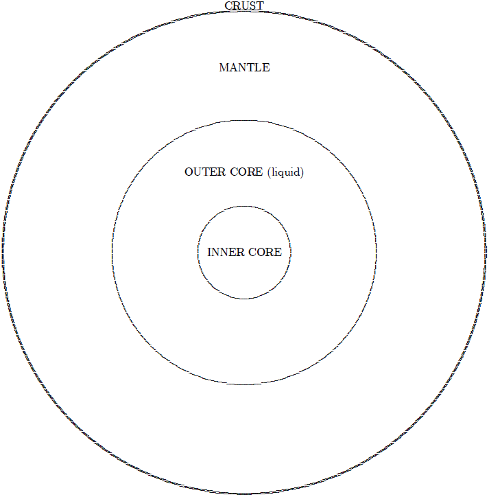 |
The solid inner core is held in place in the center of the earth by gravity. The gravitational force responsible for keeping it on center results from the fact that its density is greater than that of the surrounding liquid. But just as a rock which is normally held in place against the surface of the earth can be picked up, so the inner core can, in principle, be displaced from its central position. The force required to do this is not small, but let us ignore the whole matter of how the inner core might be caused to be displaced for the time being and concentrate only on what will happen at the surface of the earth when the inner core is displaced.
Said simply, displacement of the inner core toward the North Pole will produce a positive geoid warp (i.e., a hill in the ocean surface) at the North Pole and a negative geoid warp (i.e., a valley) at the South Pole.
Said more elaborately, since the inner core is more dense than the surrounding liquid of the outer core, moving the inner core toward the North Pole will increase the total mass which is in the northern hemisphere of the earth and decrease the total mass in the southern hemisphere. Since the force of gravity is proportional to total mass, gravity at the surface of the earth will increase in the northern hemisphere and decrease in the southern hemisphere. The water of the oceans (and everything else on earth) will feel a slight but very real gravitational attraction toward the North Pole. The water, which is free to move, will flow toward the North Pole.
If the inner core were displaced toward the North Pole it would seem to an observer on the surface of the earth that the direction of horizontal had changed. Surfaces which were previously level would now seem to be tilting downhill toward the North Pole, even though they had not actually moved at all—the local gravitational field is all that would have changed. Water which had been standing on horizontal surfaces before the inner core had been displaced would flow "down" those surfaces toward the North Pole after the displacement. If you were standing on a beach which ran east and west during such a displacement you would see the water of the ocean suddenly begin to flow "up" the beach toward the North Pole. More accurately, you would feel that the ocean had tipped up and that the beach had tipped down so that the water of the ocean was suddenly being poured out across the beach.
Noah described it this way:[27] "On the same day all the fountains of the great deep [i.e., the ocean] burst open".
It is possible to calculate fairly accurately how deep the water would be around the globe for various displacements of the inner core using the equation for the gravitational potential. Figure 2 shows the results of my calculation.[28] In this figure I have plotted the depth of water versus degrees of latitude from the North Pole. Thus 0 degrees corresponds to the North Pole, ±90 corresponds to the equator, and ±180 corresponds to the South Pole.
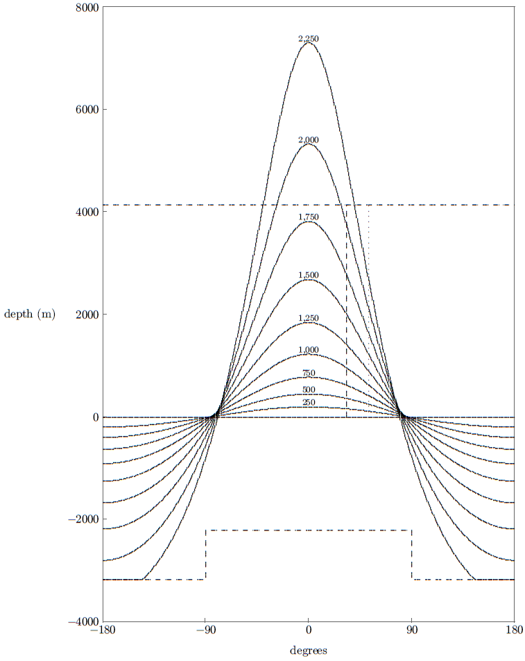 |
The depth of the water in this figure is relative to the normal ocean surface today. Notice that the vertical scale is greatly exaggerated relative to the horizontal scale. (The circumference of the earth—from -180 to +180 degrees—is about 40 million meters.) This gives the geoid warps shown artificially steep apparent slopes. In actual fact the steepest slope would only have been about 0.06 degrees, corresponding to an increase in depth of the ocean of about 1 meter per kilometer as one moved along the surface of the ocean toward the North Pole.
The dashed line at the bottom of the figure shows the ocean bottom. I have raised the ocean bottom in the northern hemisphere relative to the southern hemisphere to compensate for the excess continental volume in the northern hemisphere relative to the southern hemisphere.
The different depth curves shown result from displacements of the inner core from the center of the earth toward the North Pole. They are in steps of 250 kilometers displacement. The largest allowable displacement of the inner core is approximately 2,250 kilometers (2,258 kilometers according to the Preliminary Reference Earth Model). At this displacement the solid inner core contacts the solid mantle—it has hit the ceiling and can go no further. Notice that a portion of the southern ocean is completely dry at this maximum displacement.
I have also plotted the maximum depth of the Flood which I have previously deduced from the Biblical Flood narrative.[29] This is the horizontal dashed line at 4,145 meters (13,600 ft). It is immediately obvious that a Flood of sufficient depth to satisfy the Biblical narrative can be obtained in this way. The problem of how a large enough geoid warp could be produced is thus solved.
But now we must tackle the problem of how the inner core could possibly be displaced to such an extent.
I have given this question some considerable attention and, once again, I can find only one possible solution. It requires that the earth be impacted from space by some object of fair mass and high speed. Let me call this object a "space rock", for it was probably just a chunk of rock from space.
What would happen if a space rock plowed into the earth? From a physicist's point of view this is a very fine example of an inelastic, two-body collision. The important thing to bear in mind in such cases is that while kinetic energy is not conserved, momentum is. As a result of the conservation of momentum the space rock will impart a velocity to the earth.
Well, that's what it will do to the solid earth. The water on the surface of the earth, and the inner core down deep inside—neither of which is rigidly coupled to the solid earth—will prefer (because of inertia) to remain as they were before the collision. Thus the solid earth will take off in a slightly new direction while the oceans and inner core tend to stay behind. Consequently the inner core will be displaced relative to the center of the solid earth.
Let me try to clarify this with an example. Imagine you are standing on the end of a dock out over a still pond. Imagine that a small rowboat is floating motionless on the water several yards in front of you. Now you pick up a sizeable rock from the dock and throw it out over the water and into the boat. (We will assume the bottom of the boat is strong enough to sustain this abuse.) You see immediately that the boat has now acquired a velocity away from you. (The boat rapidly slows down because there is friction between it and the water, but the earth is in space where there is no friction and it just keeps going.)
Now we want to repeat the experiment, but this time we imagine that there is a croquet ball lying motionless on the flat floor of the boat, near the middle of the boat. You throw the rock into the boat once again (being careful to have it land near the front of the boat where it won't disturb the ball). You notice this time that the boat moves away from you as before, but the ball rolls slowly toward the back of the boat. It preferred to stay where it was in space rather than where it was in the boat. The inner core of the earth would behave in the same way.
That is the basic mechanism which caused the inner core of the earth to be displaced at the time of the Flood. But how far was the inner core displaced?
Notice, first of all, from Figure 2 that it must have been displaced at least 1,800 kilometers. Any displacement less than this produces a Flood which is too shallow according to the Biblical criterion. Obviously, we are not talking about a small displacement.
But what is intriguing is that 1,800 kilometers, the absolute minimum displacement, is already 80% of the maximum possible displacement of 2,250 kilometers. Is it possible that the inner core of the earth was actually caused to collide with the solid mantle at the time of the Flood? Further analysis of Figure 2 suggests that it very likely was.
The vertical dotted line in the figure marks the location of Mount Cilo—the location where the ark probably came to rest according to our previous analysis[30]—relative to the North Pole. Notice that while a 1,800 kilometer displacement of the inner core produces a Flood which is deep enough at the North Pole, it does not produce a Flood which is deep enough at Mount Cilo. In fact, none of the depth curves is deep enough at Mount Cilo. What this is telling us is that the impact of the space rock was not centered on the North Pole.
Up until now I have treated the impact as if it were centered on the North Pole for two reasons. First, because it is clear that it must have been fairly close to the North Pole to explain its impact on such widely separated points in the northern hemisphere as Minnesota and Mesopotamia, and also to explain its dramatic effects on the ice sheets of the Arctic region.[31] And second, because it is already hard enough to communicate the basic physics involved without having to introduce the added complication of a latitudinal offset. But now it is time to be more rigorous.
We are obviously dealing with a very large impact. It seems reasonable to assume that if the impact center were located on any continental land mass, a very large crater would be conspicuous there today. As far as I can tell, no suitably large impact crater of suitable age is known. This implies that the impact center must have been in the ocean, rather than on land. Evidently the impact center should be sought in the Arctic or North Atlantic oceans.
I find (with a compass and a globe of the earth) that these oceans are about 33 degrees from Mount Cilo. Thus, the closest the impact center can be brought to Mount Cilo is 33 degrees. This is shown as the dashed vertical line in Figure 2.[32]
To get sufficiently deep water at this location implies a displacement of the inner core in excess of about 2,075 kilometers. This is now 92% of the way to collision with the mantle. Since this is a minimum displacement, collision of the inner core with the mantle seems quite likely. It appears, in fact, that the depth of the Flood recorded by Noah on Day 150 is directly related to this physical limit on how far the inner core can be displaced.
It seems appropriate to pause for a moment here and reflect on just one thing. It now seems pretty clear that we have discovered that the Biblical Flood narrative is comprehensible in terms of displacement of the inner core of the earth. But what is most striking about this discovery is that it means that the existence of a solid inner core and a liquid outer core of the earth is embedded in and presupposed by the Biblical Flood narrative. Noah's observations cannot be explained apart from these concepts, while once they have been given it is possible to explain Noah's observations with mathematical precision. But these features of the interior of the earth have only been known to modern science for less than a century. Not even the most zealous Bible basher in academia would dare suggest that the Biblical Flood narrative originates any less, certainly, than two thousand years ago. If the Biblical narrative of the Flood is a myth, it is a mighty curious myth.
You will, no doubt, have noticed that I have understated my case. Not only must the existence of the inner and outer core of the earth be known to explain Noah's observations, but the fact that the earth is a sphere must be known, and the equation describing the force of gravity must be known, and Newton's Laws of motion must be known, and the volumes of water in the oceans of the world must be known, and the area of the continents must be known, and their relative distribution in the northern and southern hemispheres must be known, and their mean height above sea level must be known, and …. In fact, we have just seen that the very diameters of the inner and outer cores appear to be embedded in Noah's observations of the Flood.
If, as now seems appropriate, we identify the 2,250 kilometer displacement curve of Figure 2 as being that which pertained on Day 150 of the Flood, then it is possible to invert the arguments above and arrive at the conclusion that the impact center could not have been located any further from Mount Cilo than about 40 degrees. This eliminates all but a 500 mile-wide strip of ocean stretching along northern Europe and northwest Asia. The Kara Sea is the most easterly extreme of this strip. The shape of the Kara Sea has much in common with an impact crater. Could this be the spot?
It is possible to calculate the approximate speed given to the earth by the impact. For the inner core to climb against gravity to the mantle requires 7.4×1028 joules of energy. The mass of the inner core is 9.8×10²² kilograms. This implies an initial speed of the inner core relative to the solid earth after impact of 1.2 kilometers/sec.
Since Earth's orbital speed is about 30 kilometers/second, the maximum deflection of the plane of Earth's orbit resulting from this new velocity component would be only about 2.3 degrees. We are clearly not talking about knocking the Earth completely out of its orbit or proposing anything astronomically extravagant. Orbital inclinations of a few degrees are not uncommon among the planets.
That, in a nutshell, is the hemispherical Flood model. Displacement of the inner core of the earth as a result of an impact by a high energy rock from outer space appears to be the physical cause of the Flood. I hope to elaborate on this model further in future issues of The Biblical Chronologist. But there remains one more question to be answered in this preliminary report. How can the space rock be explained? Where did it come from?
Note first of all that when any sizeable rock from space falls onto land an impact crater is produced. This results from violent acceleration and rapid heating of the rock matrix lying in the immediate path of the space rock.
One would expect quite a "spray" of water from a space rock landing in the ocean, and probably an almost instantaneous conversion of a great deal of water to steam. Some unusual rainfall around the globe, in conjunction with the overflowing of the oceans resulting from the displacement of the inner core, would hardly be surprising.
Noah described what he actually witnessed in Mesopotamia this way: "on the same day all the fountains of the great deep burst open, and the floodgates of the sky were opened."[33]
Once the speed given to the earth is known it is possible to calculate the momentum of the incoming space rock using momentum conservation. From there it is possible to compute the mass of the space rock if its arrival speed is known.
If the space rock was part of the solar system prior to impact (i.e., a captive of the sun's gravitational field—these are usually called "asteroids") then its arrival speed would be necessarily between the limits of 7 and 45 miles/second, with a most probable value of 20 miles/second.[34] The 45 miles/second figure yields a minimum mass for a space rock initially in orbit about the sun. I find 1.0×10²³ kilograms.
This mass is about 170 times larger than that of Ceres, the largest asteroid. It is, in fact, about 1.4 times the mass of the moon. Even if we assume a high (but possible) density of eight times that of water, the diameter of such an object would still be about 1,800 miles—nearly one quarter the diameter of the earth.
We have seen above that the impact center seems to be limited to a narrow strip of ocean no more than 500 miles wide. It is impossible to squeeze such a large object into such a narrow strip. Thus we are led to the conclusion that a much smaller object, traveling at a much higher speed, and therefore not bound by gravitation to the sun, was involved.
This conclusion also seems supported by contemplation of what an impact between Earth and another object one quarter of the size of the earth would likely do. It seems inevitable that such a collision would entail a tremendous cataclysm—yet Noah reports no such cataclysm, as we have previously seen.[35] A smaller object thus seems mandated.
In any event, a space rock not bound to the solar system prior to impact is clearly indicated, and this raises an interesting point. The probability that a space rock should collide with the Earth on a one-time pass of the solar system seems extremely remote. The earth is very, very tiny relative to the size of the solar system.
Picture the solar system as a target. The orbit of Pluto about the sun is the outermost ring of the target. The sun itself sits at the center of the target as the bullseye. What is the probability that a shot fired at random into the target will hit the earth? It is just the cross-sectional area of the earth relative to the cross-sectional area of the target. I calculate about one chance in nine hundred billion.
But, of course, this extreme improbability does not apply to the Flood, for the Genesis narrative makes it abundantly clear that the shot was not fired at random:[36]
And behold, I, even I am bringing the flood of water upon the earth…
The Biblical Chronologist is a bimonthly subscription newsletter about Biblical chronology. It is written and edited by Gerald E. Aardsma, a Ph.D. scientist (nuclear physics) with special background in radioisotopic dating methods such as radiocarbon. The Biblical Chronologist has a threefold purpose: to encourage, enrich, and strengthen the faith of conservative Christians through instruction in Biblical chronology, to foster informed, up-to-date, scholarly research in this vital field within the conservative Christian community, and to communicate current developments and discoveries in Biblical chronology in an easily understood manner. An introductory packet containing three sample issues and a subscription order form is available for $9.95 US regardless of destination address. Send check or money order in US funds and request the "Intro Pack." The Biblical Chronologist (ISSN 1081-762X) is published six times a year by Aardsma Research & Publishing, 412 N Mulberry, Loda, IL 60948-9651. Copyright © 1997 by Aardsma Research & Publishing. Photocopying or reproduction strictly prohibited without written permission from the publisher.
|
^ Professor of Near Eastern Archaeology and Anthropology, University of Arizona; previously Director of W. F. Albright Institute of Archaeological Research, Jerusalem.
^ Editor of Biblical Archaeology Review.
^ Hershel Shanks, "Is This Man a Biblical Archaeologist?" Biblical Archaeology Review 22.4 (July/August 1996): 62.
^ Luke 17:26,27; NASB.
^ Genesis 7:16.
^ Gerald E. Aardsma, "Chronology of the Bible: 5000–3000 B.C.," The Biblical Chronologist 2.4 (July/August 1996): 1–5.
^ Gerald E. Aardsma, "Research in Progress," The Biblical Chronologist 1.1 (January/February 1995): 6–7. Gerald E. Aardsma, "Research in Progress," The Biblical Chronologist 1.2 (March/April 1995): 6–8. Gerald E. Aardsma, "Research in Progress," The Biblical Chronologist 1.4 (July/August 1995): 6–10.
^ Gerald E. Aardsma, "Noah's Flood at Elk Lake," The Biblical Chronologist 2.6 (November/December 1996): 1–13. Gerald E. Aardsma, "Research in Progress," The Biblical Chronologist 3.1 (January/February 1997): 12–14.
^ Gerald E. Aardsma, "Research in Progress," The Biblical Chronologist 2.4 (July/August 1996): 9,10.
^ Gerald E. Aardsma, "Noah's Flood at Elk Lake," The Biblical Chronologist 2.6 (November/December 1996): 8,10.
^ Gerald E. Aardsma, "The Depth of Noah's Flood," The Biblical Chronologist 3.3 (May/June 1997): 1–10.
^ Gerald E. Aardsma, "The Depth of Noah's Flood," The Biblical Chronologist 3.3 (May/June 1997): 8.
^ Gerald E. Aardsma, "The Depth of Noah's Flood," The Biblical Chronologist 3.3 (May/June 1997): 9. Gerald E. Aardsma, "Noah's Flood at Devon Island," The Biblical Chronologist 3.4 (July/August 1997): 16.
^ Gerald E. Aardsma, "Noah's Flood at Devon Island," The Biblical Chronologist 3.4 (July/August 1997): 1–16.
^ A. J. Gow, S. Epstein, and W. Sheehy, "On the Origin of Stratified Debris in Ice Cores from the Bottom of the Antarctic Ice Sheet," Journal of Glaciology 23.89 (1979): 185–192.
^ S. Herron and C. C. Langway, Jr., "The Debris-Laden Ice at the Bottom of the Greenland Ice Sheet," Journal of Glaciology 23.89 (1979): 193–207.
^ A. J. Gow, S. Epstein, and W. Sheehy, "On the Origin of Stratified Debris in Ice Cores from the Bottom of the Antarctic Ice Sheet," Journal of Glaciology 23.89 (1979): 185.
^ A. J. Gow, S. Epstein, and W. Sheehy, "On the Origin of Stratified Debris in Ice Cores from the Bottom of the Antarctic Ice Sheet," Journal of Glaciology 23.89 (1979): 185.
^ S. Herron and C. C. Langway, Jr., "The Debris-Laden Ice at the Bottom of the Greenland Ice Sheet," Journal of Glaciology 23.89 (1979): 194.
^ Gerald E. Aardsma, "Chronology of Noah's Flood," The Biblical Chronologist 3.1 (January/February 1997): 6.
^ Gerald E. Aardsma, "The Depth of Noah's Flood," The Biblical Chronologist 3.3 (May/June 1997): 8.
^ John C. Whitcomb, Jr. and Henry M. Morris, The Genesis Flood (Philadelphia: The Presbyterian and Reformed Publishing Company, 1961), 81.
^ John C. Whitcomb, Jr. and Henry M. Morris, The Genesis Flood (Philadelphia: The Presbyterian and Reformed Publishing Company, 1961), 86.
^ The tides result from the differential pull of gravity across the diameter of the earth, not the direct gravitational attraction of the moon and sun. The reader will, I trust, appreciate that I am attempting to keep technical excursions to a minimum in glossing over such points.
^ George D. Garland, Introduction to Geophysics, (Toronto: W. B. Saunders Company, 1979), 164.
^ Gerald E. Aardsma, "The Depth of Noah's Flood," The Biblical Chronologist 3.3 (May/June 1997): 1–10.
^ Genesis 7:11.
^ I have used for the density of the core the numbers from the Preliminary Reference Earth Model, Appendix F of: Frank D. Stacey, Physics of the Earth (Australia: Brookfield Press, 1992).
^ Gerald E. Aardsma, "The Depth of Noah's Flood," The Biblical Chronologist 3.3 (May/June 1997): 1–10.
^ Gerald E. Aardsma, "The Ark on Ararat?," The Biblical Chronologist 3.2 (March/April 1997): 1–12.
^ Gerald E. Aardsma, "Noah's Flood at Devon Island," The Biblical Chronologist 3.4 (July/August 1997): 1–16.
^ Notice that we are now interpreting the "degrees" on the X-axis as degrees from the impact center, rather than degrees from the North Pole. Strictly speaking this is not proper because the elevated ocean floor must remain centered on the North Pole rather than moving with the impact center. But the displacement of the impact center from the North Pole seems small enough to ignore this at the level of accuracy afforded by this simple model.
^ Genesis 7:11.
^ Stanley P. Wyatt, Principles of Astronomy (Boston: Allyn and Bacon, 1964), 223.
^ Gerald E. Aardsma, "Research in Progress," The Biblical Chronologist 2.4 (July/August 1996): 9,10.
^ Genesis 6:17.