
| |
| Volume 4, Number 3 | May/June 1998 |
The date and the nature of Noah's Flood are now behind us, and pre-Flood Biblical chronology beckons. Before venturing into chronology proper in this early portion of the Biblical/historical narrative it is necessary to get our geographical bearings. Just as the Biblical narrative of the Exodus and Conquest must be tied into the geographical location of Egypt and Palestine to be properly understood, and just as the Biblical narrative of the waning of the Flood must be tied into the geographical location of Ararat to be properly understood, so the pre-Flood Biblical narrative (Genesis 1 through 6) must be tied into its proper geographical location to be properly understood.
The region called Eden is most conspicuous in these early chapters; it appears to be the hub of the events which they describe. The importance of the geographical location of Eden to a correct understanding of the early chapters of Genesis seems implicit in the narrative itself. In an otherwise terse historical account, spanning more than one and a half thousand years in just six short chapters, a significant fraction of Chapter 2 is devoted to the task of communicating where the events being described took place. Apparently the Author of Scripture found the geographical setting of Eden an important fact that we should know.
There are two widespread misconceptions affecting the present study which must be dealt with right at the start if we are to proceed in unison. The first of these is in regard to the impact of the Flood itself on the topography of the earth. The second has to do with a mistaken equating of the Garden of Eden with the region of Eden.
A misconception which has arisen out of the cataclysmic Flood model, and which has been greatly popularized by that model's modern proponents, is that the topography of the earth was so dramatically changed by the Flood that the geographical indicators of the location of Eden in Genesis 2 can no longer be used in the post-Flood world. Assyria and the Euphrates river, mentioned in connection with Eden in Genesis 2:14, for example, are asserted, in this view, to correspond, not to the Assyria and Euphrates river with which we are all familiar from post-Flood history and geography, but rather to pre-Flood entities bearing no geographical relationship to the post-Flood Assyria and Euphrates. The post-Flood Assyria and Euphrates, it is claimed, were named after the pre-Flood Assyria and Euphrates by Noah's descendants, who carried the names forward into the post-Flood world, much as early settlers of America carried Old World place names with them to their new homes.
We now know that this claim is false. The obliteration of pre-Flood rivers and the formation of new post-Flood rivers would require entire drainage basins to be restructured by the Flood. An enormous quantity of earth and rock would need to be moved around over the surface of the earth to accomplish such a thing. The size and placement of high mountains (whose meltwaters feed rivers during the dry summer months) would need to be profoundly altered, for example. But we now know what the Flood was like, and we know that it did none of these sorts of things.
This fact is most easily demonstrated using archaeological data. We know, from the Bible's own chronology, when the Flood happened, and it is unquestionably the case that many well-preserved archaeological strata can be found in Palestine and elsewhere in the Near East which predate the proper Biblical Flood date. We have repeatedly seen that the Biblical date for the Flood coincides with the close of the Chalcolithic in Palestine,[1] which archaeological period it terminated. But Chalcolithic and earlier archaeological strata are abundant throughout the Near East.
Now if the action of the Flood was gentle enough to preserve pre-Flood archaeological tells—which are just big mounds of archaeological strata composed mainly of dirt—how could it have been violent enough to destroy high, rocky mountains? Furthermore, how could it have reworked the mountains and drainage basins while at the same time preserving the pre-Flood archaeological, layer-cake strata which are found upon these mountains and within these drainage basins today?
The extra-Biblical claims about the violent tectonic potency of the Flood arising out of the cataclysmic Flood model are no longer credible. The cataclysmic Flood model itself has been shown to be false,[2] and its assertions about how the Flood profoundly altered Earth's topography should no longer be given any credence.
A second misconception affecting the present study is that Adam and Eve were banished from the Eden region after the Fall. This would then place them (and the remainder of the pre-Flood Biblical narrative) in some undefined geographical setting away from the Eden region after they had been banished. But this is a misconception. It results from an erroneous equating of Eden with the Garden of Eden.
The Garden of Eden was just a garden in the Eden region—it was not itself the whole of the Eden region. This is clearly shown in Genesis 2:8 which says that the Garden was located "in Eden"—not that the Garden was Eden. The Garden of Eden probably occupied just a few acres in the Eden region since it was tended initially by Adam alone.[3]
Adam and Eve were banished from the Garden of Eden (Genesis 3:23–24) only, not the entire Eden region. The narrative implies in several ways that they continued to dwell in the Eden region. For example, the cherubim appointed to guard the way to the Tree of Life[4] was stationed at the east of the Garden, not east of the entire Eden region. The fact that the cherubim had to guard the Garden to keep Adam and Eve out implies that they were still living local to the Garden, and this would mean that they continued to live in the Eden region in which the garden was situated.
Another example is furnished by the emigration of Cain. The text seems to imply that he went out from the Eden region when he was banished for the murder of Abel. Genesis 4:16 informs us that he "went out from the presence of the Lord, and settled… east of Eden".
Thus the Eden region appears to be the proper geographical setting of the central thread of the Biblical narrative from Adam to Noah. This setting is established early in Genesis 2, and no change of setting is indicated until the ark comes to rest upon the mountains of Ararat following the Flood.
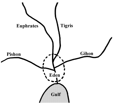
Because of the detailed description of the geographical location of the Garden of Eden recorded in Genesis 2:10–14 it is possible to locate this region with considerable confidence on a map of the world today. The only caveat is that one must not suppose that the topography and climate of the region in question are today identical to those which pertained some seven thousand years ago when the events of Genesis 2 took place. With this in mind, comparison of the Biblical description with modern world geography quickly reveals that Eden is, in fact, obviously to be identified with southeastern Iraq—the land at the head of the Persian Gulf. This conclusion is arrived at as follows.
The mention of Assyria and the Euphrates river in Genesis 2:14 provides a very quick, rough location of Eden. This allows the region of interest to be immediately restricted to that of modern-day Iraq.
Identification of the Hiddekel river (Genesis 2:14; KJV) with the Tigris follows immediately from its association with Assyria in verse 14 and further strengthens this identification. The fact that the Tigris and Euphrates flow in separate channels until they reach southeastern Iraq (just below Qurna) restricts the location of Eden further to this southeastern region. This follows from the fact that Genesis 2:10 informs us that these rivers were joined in the Eden region.
The Gihon river of verse 13, and the Pishon river of verse 11 cannot be equated with their modern counterparts with certainty today. Too little information is given in the Biblical descriptions and too many changes to climate and drainage patterns have taken place in the intervening seven thousand years to allow certainty. But it is still possible to make some probable identifications, and these tend to corroborate southeastern Iraq as the location of Eden.
A dry riverbed crossing the Arabian Peninsula toward the head of the Persian Gulf has recently been identified in satellite photographs.[5] This appears to be a good candidate for the Pishon river at the present time.[6] The river which once occupied this bed flowed into southeastern Iraq from the west.
Two rivers flow into southeastern Iraq from the east today. These are the Kerakh (or Karkheh) and the Karun, both of which drain the western side of Iran. The Gihon is very probably to be identified with one of these, or possibly even a hypothetical ancient confluence of the two.
Thus the modern topography of southeastern Iraq is seen to adequately satisfy the geographical description of the location of Eden given in Genesis 2. No other geographical location on the entire globe does so. There thus seems little reason to doubt that southeastern Iraq is the modern equivalent of the Biblical Eden region.
This geographical identification of Eden, not surprisingly, immediately clarifies two otherwise obscure passages in the narrative of Genesis 2. The first passage has to do with the description of the joining of the rivers in Genesis 2:10, and the second deals with the lack of rainfall and the "mist" which used to rise from the ground in Genesis 2:5–6.
Genesis 2:10 is translated today (NASB):
Now a river flowed out of Eden to water the garden; and from there it divided and became four rivers.
I think it is not uncommon for this verse to be understood to mean that a river was sourced (from a spring) in the Garden of Eden, and that after the spring water had flowed out of the Garden it divided into four separate branches which became the Tigris, Euphrates, Pishon, and Gihon rivers. In this view one should look for Eden at the source waters of these four rivers rather than at their confluence.
But such a view immediately encounters two problems. First, the Tigris and Euphrates rivers do not source from the same point today, and neither do the other rivers mentioned above. And second, rivers in general just don't behave this way.
Rivers don't generally start to flow from a single point and then branch out. In fact it is the usual case that even a single river will source its water from a large number of different points scattered over a large geographical region, these different branches then joining together. A glance at a map of the Mississippi river will quickly illustrate this point for example. Rivers don't generally start at a single point and divide into major branches downstream, as this view requires; rather, their separate branches and tributaries flow together as one goes downstream.
Connecting the Biblical description of the location of Eden to its modern geographical counterpart quickly clarifies the intended meaning of this verse. The river which watered the Garden of Eden resulted from the confluence of these four rivers; it was not the source of them. Its modern counterpart is the Shatt al-Arab—although it must be emphasized that the Shatt al-Arab may not be flowing in the same bed as its ancient, Biblically recorded predecessor. The correct understanding of the verse appears to be:
Now a river flowed out of [the] Eden [region, which river served] to water the garden; and from there [the Eden region] it divided and became four rivers.This view is illustrated in Figure 1.
 |
The geographical identification of Eden with southeastern Iraq impacts our understanding of Genesis 2:5–6 also. And, interestingly, when these verses are properly understood they further substantially strengthen the claim that Eden was located in southeastern Iraq. These verses are translated (NASB):
Now no shrub of the field was yet in the earth, and no plant of the field had yet sprouted, for the Lord God had not sent rain upon the earth; and there was no man to cultivate the ground. But a mist used to rise from the earth and water the whole surface of the ground.
The meaning of these verses seems very obscure and even internally inconsistent at first reading. These verses, when read together with those which precede them in Genesis 1 and 2, seem to say that there were no plants on earth because God hadn't started the present hydrological cycle involving rainfall yet. But then they say the whole surface of the ground was watered by a mist which rose up from the earth. This seems somewhat confusing. If the ground was watered by a mist, wouldn't that have served to grow the plants?
This is made further confusing by the knowledge we have from Genesis 1:11–13 that plants had already been created on the third Creation Day. Why have these plants disappeared from the narrative in Genesis 2:5?
I suggest that the proper answer to such questions is that these verses are not talking about the global hydrological cycle, and that they are not talking about plants in general. I suggest that confusion concerning the meaning of these verses arises out of a failure to recognize that the perspective of the narrative changes from panoramic to a very geographically localized one beginning at verse 5. I suggest that there is a complete break in the narrative and change in perspective beginning at Genesis 2:5. The preceding verses, starting at Genesis 1:1, have dealt with the Creation of the earth and cosmos. The perspective of these earlier verses is obviously panoramic. But, I suggest, Genesis 2:4 terminates that section of the narrative, and from Genesis 2:5 onward the perspective changes to a very local one.
We have just seen that the setting of the garden of Eden, described in verses 10 through 14, is in southeastern Iraq. This setting, I suggest, also applies to verses 5 through 9. The climate of southeastern Iraq is desert. That is why rain is lacking in verse 5. The plants "of the field", I suggest, should be understood to mean cultivated, agricultural plants, such as rye and barley. These could not grow by themselves in the desert where there was too little rainfall. Their cultivation there would require artificial irrigation—the construction of shallow canals to conduct water from the rivers out to the fields—and this would require human involvement. Verse 5 ("Now no shrub of the field was yet in the earth, and no plant of the field had yet sprouted, for the Lord God had not sent rain upon the earth; and there was no man to cultivate the ground.") is simply informing us that the setting of this new portion of the narrative is in the uninhabited desert.
Verse 6 ("But a mist used to rise from the earth and water the whole surface of the ground.") is telling us more about the new, changed setting of the narrative. The NASB notes that the word translated as "mist" might also be translated "flow". Verse 6 then reads "But a flow used to rise from the earth and water the whole surface of the ground." While it is very difficult to see what a mist rising from the earth might be referring to, it is easy to see what a flow rising from the earth corresponds to if the setting is near the Persian Gulf in southeastern Iraq. It then naturally refers, I suggest, to the daily fresh-water flooding of regions occasioned by the tides in the Persian Gulf. When the tide was low the river from Eden emptying into the Persian Gulf would drain and expose the surrounding land. When the tide was high the river would back up, flooding the ground near the Gulf. This regular tidal flooding is, I suggest, the physical reality which Genesis 2:6 is describing when it says "a flow used to rise from the earth and water the whole surface of the ground".
This periodically flooded land would be swamp or marsh, in which no plants "of the field" would naturally grow either. But these swamps could be easily turned to productive agriculture by the simple expedient of building low earthen dikes to block out the water at high tide and allow controlled irrigation. If the modern slope of the land is any guide to that which pertained seven millennia ago then this tidal flooding may have extended a considerable distance inland from the Persian Gulf.
As much as 500 km north of the Gulf coastline, the general landscape is still less than 20 m above sea level, giving a gradient of 1:25,000.[7]
Earlier, in the nineteenth century, Loftus was similarly impressed with the lush greenery of the cultivated gardens in the palm groves of Qurna [over 100 miles inland from where the Shatt al-Arab empties into the Persian Gulf], and noted that Gulf tides flowed twenty miles to the north, thus always giving the impression that the town was on the sea coast.[8]
Here again, all that was needed for productive agriculture was a man to build the dikes and oversee the irrigation of the land. And this, we are informed in verse 7, was what God supernaturally furnished by the creation of Adam.
Thus Genesis 2:5–6 define the general setting of the Garden of Eden. These verses tell us that the setting was one of mixed desert and tidal marsh. This is precisely what is found in southeastern Iraq below the confluence of the Tigris and Euphrates rivers today.
It is obviously a mistake to suppose that the topography and climate of southeastern Iraq is exactly the same today as it was seven thousand years ago. Seven thousand years is a very long time, and even changes which are nearly imperceptible in any individual's lifetime can sum to significant alterations over such a long time.
But an even greater error is to suppose that the carefully detailed topography of the Eden region provided for us in Genesis 2 has no correspondence to the real world today. This is the greater error because it has the effect of muting and distorting the meaning of Genesis 2. Many Christians, for example, have taken the lack of rain in Genesis 2:5 to mean that there was no rainfall anywhere at all before the Flood. They have used this mistaken interpretation to help build an imaginary global "greenhouse" climate in the pre-Flood world, maintained by an extra-Biblical "vapor canopy" above Earth's atmosphere. When Genesis 2 is properly connected to the real world using the detailed geographical description of the location of Eden which the Author of Scripture has been careful to provide, the Biblical basis for the idea that there was no rainfall before the Flood simply evaporates.
While the modern topography and climate of southeastern Iraq cannot be regarded as identical to those which pertained seven thousand years ago, the similarities which yet remain to the Eden region described in Genesis 2 are large and quite striking. Objective analysis cannot help but conclude that the region the Bible calls Eden is essentially the same as the geographical region we refer to as southeastern Iraq today. ◇
Over the past several years I have worked my way back through Noah's Flood, slowly discovering more and more about when it happened, what it was like, and what its physical cause was. I have published the stages of this odyssey in this publication as they have unfolded. When read in their published order these yield a view of the Flood in reverse chronological order.
It is now possible, for the first time ever, to tell the complete geophysical story of the Flood in proper chronological sequence from beginning to end. The present "class session" is devoted to that purpose. This is a review, in correct chronological order and all together in one place, of what has been learned over these past many months. I have provided a large number of "chalkboard sketches" (my apologies for their roughness) to help us visualize the various Flood phenomena.
The Flood happened 3520±21 B.C. according to calculations based upon the Masoretic text of the Old Testament and the missing millennium thesis.[9] Secular chronometers corroborate this date certainly to within plus or minus two centuries.[10] The Flood marks the end of the Chalcolithic in Palestine and the end of the Uruk period in southern Mesopotamia.[11] Civilization, which had its roots in southern Mesopotamia and had spread throughout the Near East by 3500 B.C., was abruptly terminated by the Flood.
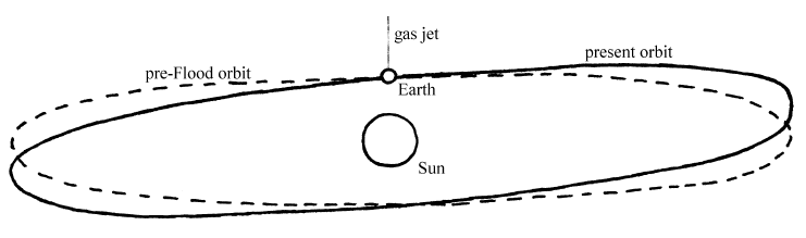
The root physical cause of the Flood was the collision of the Earth with a very high speed cosmic projectile (Figure 2).[12] My best guesstimate at present is that the projectile was a 50 kilometer diameter chunk of iron/nickel, similar in composition to known asteroids. It was probably traveling in excess of 6×10^6 meters per second (13 million miles per hour) immediately prior to impact. The projectile's very high velocity suggests that it was not a member of the solar system prior to the impact.
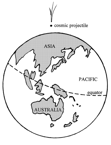 |
The impact occurred within the Arctic Circle, on the northwestern coast of Asia. The Kara Sea may possibly be the impact site.[13]
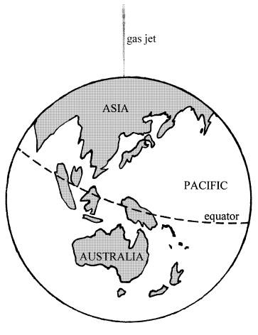
The projectile penetrated the atmosphere and punctured a tunnel to some depth into the earth before exploding. The explosion released an enormous amount of energy (greater than 2×10¹⁵ MT) at the base of the tunnel, which vaporized the projectile and surrounding earth. The very hot vapor was ejected back up the tunnel and back out into space (Figure 3).
 |
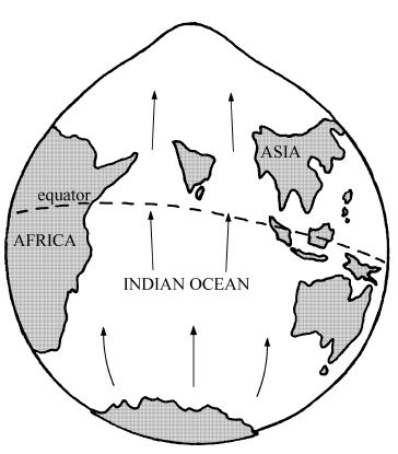
The ejection of hot gas at speeds in excess of Earth's escape velocity persisted for probably many minutes. This produced a thrust on the earth, just as the gases ejected from a rocket engine produce a thrust on the rocket. The result was that the Earth experienced a sustained acceleration, ultimately acquiring a new, southerly velocity component in excess of 280 meters per second (630 miles per hour).
The physics at this point is familiar to any who have experienced takeoff in a jet airplane. The thrust of the jet engines causes the aircraft to accelerate rapidly down the runway. Passengers feel that they are being pressed back into their seats, though they actually are being pressed forward by the back of their seats so their acceleration matches that of the airplane. Otherwise they would be left behind.
If you placed an aquarium partially filled with water on the floor of the aircraft and watched it during takeoff you would see the water pile up toward the back of the aquarium (because of inertia) as the aircraft began to accelerate down the runway, even while the aircraft was still horizontal.
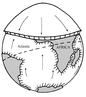
The same phenomenon occurred when the earth was accelerated by the thrust of the very hot gases escaping into space. The waters of the oceans of the earth began to flow toward the impact center and pile up there because of their inertia. This resulted in rapid flooding of much of the northern hemisphere of the earth.[14] After a few hours an enormous mountain of water had collected above the north impact pole (Figure 4).
 |
Eventually the water mountain began to collapse under its own weight. The result was an enormous reflected pulse of water. This rapidly developed into a globe-circling, giant tsunami rushing toward the south at tsunami speeds (Figure 5).
 |
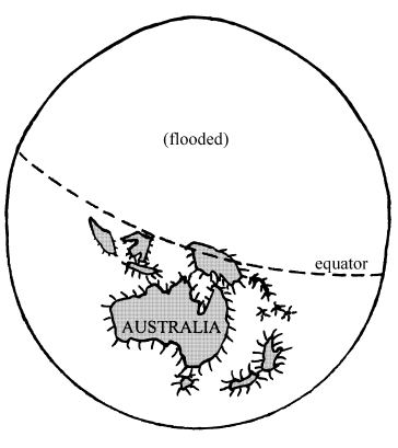
Within 24 hours of the impact the initial motion of the water of the oceans had largely ceased—the water mountain had collapsed and the Flood tsunami had dissipated (Figure 6). But much of the water of the southern oceans had drained away to the north and the northern hemisphere remained flooded.
 |
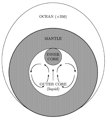
This water profile persisted for some 150 days. It was maintained by the gravitational attraction of the inner core of the earth which had left its normal central position and risen to the mantle as a result of the acceleration of the earth at the start of the Flood. The inner core remained pinned in its off-center position by the motion of the outer core fluids which surrounded it (Figure 7).
 |
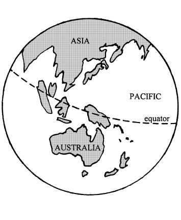
One hundred fifty days—nearly five months—later, the outer core fluid had slowed sufficiently for the inner core to begin its slow descent back to the center of the earth. As it fell the Flood diminished in the northern impact hemisphere and the southern oceans began to fill toward their normal level once again.
The descent of the inner core proceeded slowly, but by a year following the impact the inner core and the water of Earth's oceans were pretty much back to normal (Figure 8). The principal residual effect of the Flood was that the plant, and especially the animal populations of the northern biosphere had been devastated and would need to start up again pretty much from scratch.[15]
 |
This, I believe, is an accurate outline of what happened at the time of Noah's Flood. I have called this view of the Flood the hemispherical Flood model since only one hemisphere of the earth was flooded in this view.[16] While this scientific model yet requires a great deal of quantitative tuning, I am aware of no data at present, either Biblical or secular, which this basic model fails to satisfy. I am also aware of no other scientific model of the Flood which is able to make this claim (including the very popular "model" within academia at present that the Flood never happened).
The elucidation of the hemispherical Flood model, with its supporting Biblical and secular data, amounts to the discovery of Noah's Flood in history. This is a discovery of major proportions, and one which affects many fields (Figure 9). I would like to report at this point that these many fields have eagerly awaited this discovery and are even now actively reaping the benefits of it. But this is far from the truth. It was nearly fifty years after Gregor Mendel published the laws of inheritance that the world became aware of his discovery. I fear at times that the discovery of the overlooked millennium in 1 Kings 6:1 and all that logically flows from it—including, most recently, the hemispherical Flood model—may break his record.
 |
There are several problems making communication of the discovery of Noah's Flood in history very difficult at present. Of highest rank is the fact that one must respect the integrity and value of both the Bible and the secular data—especially the chronological data—to arrive at this discovery. I have found that the great majority of contemporary scholars, both Christian and non-Christian, hold debilitating prejudices in at least one of these two areas.
A second problem, for me, is that I have very little time available at present to devote to the task of winning general acceptance of the hemispherical Flood model. The task of discovering the truth is separate from the task of communicating the truth. In the present case both are more than full-time occupations. I have had to choose at each stage of my research whether to focus on communicating the truth which has already been found to that point, to win general acceptance of it, or to press on toward further discovery.
My choice has consistently been the latter. I have, of course, felt a responsibility to adequately document what has been found—hence the book explaining the missing millennium thesis[17] and this bimonthly publication, The Biblical Chronologist, recording the discoveries flowing from that thesis as they are made. And I have certainly been willing to do whatever I reasonably could to communicate to a wider audience the discoveries which have already been made. But I have consistently felt, before the Lord, that my personal primary responsibility is to discover and document the truth, rather than trying to communicate it to the masses.
This may change in the future. My goal of many years has been to harmonize Biblical and secular chronologies of earth history from the present back to the beginning of the Creation. When I began to work on this goal a seemingly wide gulf of seven Biblical/historical books (Genesis through Judges) separated me from it. Now this goal is just six short chapters in Genesis away. It seems possible the goal may soon be reached and that I might then have more time to devote to the problem of communicating all that has been found.
But such a change of emphasis would obviously be inappropriate at this time—pre-Flood Biblical chronology remains to be solved and I must press on with the discovery process. While only six short chapters in Genesis stand between me and the goal, these chapters pose some seemingly monumental problems for Biblical chronology. The problems of the antiquity of man, the age of the earth, and the age of the cosmos lie here. These problems have staggered and crippled Christian apologetics for well over a century now. They need to be solved. Now is no time to let up on the research.
The mystery of the Flood is solved. The mystery of the Creation lies before us. Let us press on. ◇
The Biblical Chronologist is a bimonthly subscription newsletter about Biblical chronology. It is written and edited by Gerald E. Aardsma, a Ph.D. scientist (nuclear physics) with special background in radioisotopic dating methods such as radiocarbon. The Biblical Chronologist has a threefold purpose: to encourage, enrich, and strengthen the faith of conservative Christians through instruction in Biblical chronology, to foster informed, up-to-date, scholarly research in this vital field within the conservative Christian community, and to communicate current developments and discoveries in Biblical chronology in an easily understood manner. An introductory packet containing three sample issues and a subscription order form is available for $9.95 US regardless of destination address. Send check or money order in US funds and request the "Intro Pack." The Biblical Chronologist (ISSN 1081-762X) is published six times a year by Aardsma Research & Publishing, 412 N Mulberry, Loda, IL 60948-9651. Copyright © 1998 by Aardsma Research & Publishing. Photocopying or reproduction strictly prohibited without written permission from the publisher.
|
^ Gerald E. Aardsma, "Radiocarbon Dating Noah's Flood," The Biblical Chronologist 3.6 (November/December 1997): 1–11.
^ Gerald E. Aardsma, "Research in Progress," The Biblical Chronologist 2.4 (July/August 1996): 9–14.
^ Genesis 2:15.
^ Genesis 3:24.
^ Molly Dewsnap, "How to Find a River—No Divining Rod Needed" Biblical Archaeology Review 22.4 (July/August 1996): 55.
^ James A. Sauer, "The River Runs Dry" Biblical Archaeology Review 22.4 (July/August 1996): 52–54,57,64.
^ J.N. Postgate, Early Mesopotamia: Society and Economy at the Dawn of History (New York: Routledge, 1994), 6.
^ Theresa Howard-Carter, "The Tangible Evidence for the Earliest Dilmun," Journal of Cuneiform Studies 33 (1981): 210–223.
^ Gerald E. Aardsma, "Chronology of the Bible: 5000–3000 B.C.," The Biblical Chronologist 2.4 (July/August 1996): 1–5.
^ Gerald E. Aardsma, "Noah's Flood at Elk Lake," The Biblical Chronologist 2.6 (November/December 1996): 1–13. Gerald E. Aardsma, "Noah's Flood at Devon Island," The Biblical Chronologist 3.4 (July/August 1997): 1–16. Gerald E. Aardsma, "Radiocarbon Dating Noah's Flood," The Biblical Chronologist 3.6 (November/December 1997): 1–11.
^ Gerald E. Aardsma, "Research in Progress," The Biblical Chronologist 1.4 (July/August 1995): 6–10.
^ Gerald E. Aardsma, "Space Rock Impacts and Noah's Flood," The Biblical Chronologist 4.2 (March/April 1998): 1–11.
^ Gerald E. Aardsma, "The Cause of Noah's Flood," The Biblical Chronologist 3.5 (September/October 1997): 12–13, and Gerald E. Aardsma, "Zoogeography and Noah's Flood," The Biblical Chronologist 4.1 (January/February 1998): 1–7.
^ Gerald E. Aardsma, "Research in Progress," The Biblical Chronologist 4.1 (January/February 1998): 11–16.
^ Gerald E. Aardsma, "Zoogeography and Noah's Flood," The Biblical Chronologist 4.1 (January/February 1998): 1–7.
^ Gerald E. Aardsma, "The Cause of Noah's Flood," The Biblical Chronologist 3.5 (September/October 1997): 1–14.
^ Gerald E. Aardsma, A New Approach to the Chronology of Biblical History from Abraham to Samuel, 2nd ed. (Loda IL: Aardsma Research and Publishing, 1993).