
| |
| Volume 7, Number 3 | May/June 2001 |
 |
I never intended to get involved in a search for Noah's ark. Years ago, whenever I heard of someone searching for the ark, I mainly wondered what made such people tick. Risks to one's reputation are high in this business.
As with most things I research and write about these days, I became involved in searching for the ark as a result of a Biblical chronological discovery I made back in 1990. I discovered that 1000 years had accidentally been dropped from Biblical chronology as a result of an ancient copy error in the text of 1 Kings 6:1.[1] I had no idea of the far-reaching consequences of this discovery at the time.
In hindsight, I should have known. Chronology is, after all, the backbone of history. You can't overlook a full millennium in Biblical chronology and expect there to be no consequences for Bible history.
In point of fact, as I began to investigate the matter, I quickly found that Bible history was in a serious mess. Every turn of the archaeologists' spades seemed to be proving the Bible false. Nothing the archaeologists were finding seemed to tell the same story the Bible told about the past. The scholars had abandoned the Biblical account of the Exodus and the Conquest and were making up their own stories about how the nation of Israel had come to be. They had abandoned the patriarchs: Abraham, Isaac, and Jacob. They weren't even talking about the Flood, or the Garden of Eden any more. These they treated as outright fairy-tales.
Well, of course. What else should one expect with Biblical chronology shortened a full thousand years relative to secular chronologies? You can't find the Exodus in archaeology if you are looking for it 1000 years later in history than it happened.
Nobody that I heard ever mentioned these problems from the pulpit or on religious broadcasting. The few who even mentioned archaeology said that it overwhelmingly confirmed what the Bible said—about the Conquest of Jericho for example! I don't know how they came to such conclusions, but I do know they didn't come to them through any rational process rooted in archaeological facts. The archaeologists had found that Jericho hadn't even existed as a walled city at the traditional Biblical date of the Conquest. But I guess it's pretty difficult to make a winning sermon out of that.
What a difference, though, when once this missing millennium was restored to Biblical chronology. Suddenly archaeology and the Bible began telling the same story. I found I was able, for the first time, to make sense of many things which previously had seemed hopelessly obscure.
Noah's Flood is a case in point.
The Bible informs us that the Flood lasted a year, that it covered the high mountains, and that it drowned all but a few individuals living at that time. Here was no ordinary event. No ordinary flood—not even a very BIG ordinary flood—covers high mountains. The Biblical narrative seemed clearly to imply that Noah's Flood was a global-scale catastrophe.
And therein lay the problem. No one seemed able to say just when in history this Flood had happened. But catastrophes are generally easily dated. They bring many physical processes to a screeching halt, so that those processes must start up anew when the catastrophe is over. This is wonderful for dating purposes. For example, when a volcano erupts, it may bury whole landscapes beneath a blanket of hot ash. When the volcano quiets down again, new trees begin to grow on top of the ash. If one does not wait too many centuries, the date of the eruption can be determined by simply counting the number of annual rings in the oldest trees growing on top of the ash. And even if one does wait too long for this simple dating method to work, they can still—even after many millennia, if conditions are right—dig up charred logs of trees which were buried by the ash and date them using radiocarbon.
Catastrophes are great for dating.
So how come nobody seemed to be able to date the Flood—evidently the king of all catastrophes?
This was important. Inability to assign a historical date to the Flood has serious consequences for the credibility of Genesis. It makes the Bible look like it is telling fairy tales rather than true history. Notice that nobody has ever been able to assign a definite date to Goldilocks' encounter with the Three Bears either…
Six years following the discovery of the missing thousand years in 1 Kings 6:1 I was ready to tackle the problem of the Flood head on. I had spent the previous six years getting my feet under me: first subjecting the missing millennium thesis to every test I could think of to see if it held up to critical scrutiny, and then, once I had convinced myself that it did, going on to apply the new Biblical chronology which resulted from restoration of the missing thousand years, to solve the Exodus/Conquest problem. By the end of that exercise I knew I was standing on solid ground. The new chronology dated the Exodus to 2450 B.C. I soon found that all of secular history and archaeology overwhelmingly corroborated the Biblical narrative of the Exodus at that date, and the Conquest forty years later.
But what about earlier times? The new chronology placed the Flood within a few decades of 3500 B.C. Would secular studies confirm a suitable Flood event at such a remote date? Would the missing millennium thesis succeed with the Flood as it had with the Exodus? Would the necessary tell-tale signs of Noah's Flood be found within the secular data 3500 B.C.?
I attacked the problem of the Flood using the secular chronometric record afforded by the laminated sediments from the bottom of Elk Lake, Minnesota. My plan of attack was simple. If the Flood happened near 3500 B.C., as the new Biblical chronology predicted, and if the Flood was a global-scale event, as the Biblical narrative seemed to say, then we should see something unusual in the sedimentary record from the bottom of Elk Lake near 3500 B.C. I determined simply to take a look at what the primary researchers had found in the sediments at the bottom of Elk Lake, to see whatever these sediments might reveal.
The story of how those sediments revealed the Flood—within dating uncertainties of 3500 B.C., as the new chronology predicted—is detailed elsewhere.[2] I will not review it all here, but one result of that study is important in the present context.
The sediments from the bottom of Elk Lake revealed that the Flood had not been cataclysmic.[3] That is, Elk Lake said that the Flood had not been the highly energetic event some have claimed.[4] The evidence from Elk Lake was contrary to the idea that the Flood had ripped up earth and stone to great depth and laid down vast sedimentary deposits. Indeed, the Flood had deposited just one meter of extra sediment at Elk Lake. Normally it would take 500 years or more to deposit this thickness of sediment at the bottom of Elk Lake, but even so one would expect a great deal more than just one meter of extra sediment to result from a cataclysmic, global-scale event. Furthermore, the sediments immediately beneath the Flood layer at Elk Lake were found to be still nicely laminated. They had evidently not been disturbed by the Flood.
Obviously, the Flood had not been a cataclysm. It had not even been a global washing machine. It had evidently been more like a tub—gradually filling when the tap is turned on, and then gradually emptying when once the plug is pulled.
But here was a fine mystery. How, according to the laws of physics, does one get a global-scale, catastrophic, relatively calm Flood?
It was clear that I had much to learn yet about the true nature and cause of the Flood. I was eager to carry the work forward and get to the truth of the matter. What had Noah's Flood really been like?
Of most pressing concern was the depth of the Flood. How deep had the waters of the Flood been at Elk Lake? How deep had they been over the entire globe? I needed to know this so I could begin to predict where else one might look to find the clearest evidences of the Flood. A single sedimentary evidence from a small lake in Minnesota was obviously not enough to tell the whole story. A global-scale Flood needed global-scale evidence.
But global-scale evidence was not easily obtained. Elk Lake is a very special lake. It is unusually deep relative to its surface area. Its great depth prevents oxygen from mixing down to the bottom of the Lake, which has prevented aquatic organisms from being able to live at the bottom of the lake. This has kept the bottom sediments from being mixed, preserving their seasonally laminated structure for thousands of years. These carefully preserved laminations were the key to finding the Flood at Elk Lake. They provided the basic chronology, showing which laminations correspond to 3500 B.C., and thereby pin-pointing the location of the Flood sediments at the bottom of the lake. I knew that this sort of reliable internal chronology was essential to the task of demonstrating the Flood in other geophysical reservoirs as well. But geophysical reservoirs sporting such chronologies are relatively rare.
Fortunately, there was one obvious candidate—the Greenland ice sheet. I knew a tremendous amount of work had been done on this massive ice sheet in recent decades by international teams of scientists. Great cores of ice had been drilled through the ice sheet from top to bottom. These cores provided a record of the past extending back long before the time of Noah's Flood. The upper sections of these cores were visibly laminated with annual layers of snow and ice. One could count back annual layers and thereby determine where in the ice core the Flood had happened.
But the big hitch in all of this was trying to say just what the Flood would have done to the Greenland ice sheet. What should we expect to see back at 3500 B.C. in the ice cores from Greenland? Would the Flood have deposited a great depth of snow on the ice sheet, or would it have dumped torrential rain on the ice sheet and thereby melted it back? Would the surface of the ice sheet have been above or beneath the water of the Flood? To even begin to answer these questions I needed to know more about the nature of the Flood. Most especially, I needed to know how deep the Flood had been in Greenland.
And that's how I got involved in a search for Noah's ark.
I had to figure out the depth of the Flood over the globe. The only way to do that, if it was to be done at all, was from the Biblical record of the event. Noah had recorded, for example, that the ark came to rest within the mountains of the Ararat region. If we knew where the ark had come to rest, we would immediately know the depth of the Flood at that point on the globe at that time; it would just be equal to the altitude at which the ark had come to rest.
But where had the ark come to rest?
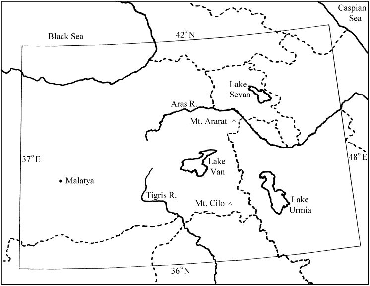
Modern tradition favors Mount Ararat. But the Biblical account doesn't altogether go along with this choice. It says, for example, that "the ark rested upon the mountains of Ararat",[5] not on Mount Ararat. To the Bible writer Ararat was a geopolitical region, not a mountain. Mount Ararat doesn't fit the Biblical description of the landing place of the ark because it isn't really situated in "the mountains" of Ararat, as any topographical map of the region shows. In addition to this, extensive searches had been conducted on Mount Ararat for years and no remnants of the ark had been found there. The ark was a very big boat. If it had landed on Mount Ararat, I reasoned, surely somebody should have stumbled upon something evidencing its presence there.
 |
It was clearly inappropriate to trust modern tradition. I would need to go back to the source of all our knowledge about the Flood—back to the Genesis account—and see if it might contain some previously overlooked clues to the proper mountain.
The more I read the account the more I came to see that some very good clues were embedded in it. For example, the proper mountain had to be located "in the mountains" as noted above. This specified a mountainous area, not a lone mountain surrounded by plain. As another example, we learn from the text that neighboring mountains had only become visible 72 days after the ark had come to rest on its mountain, during which time the water had receded steadily.[6] This immediately implied that the mountain the ark had come to rest on must have been the tallest mountain in its general vicinity.
Ultimately I found seven clues from the Biblical narrative. I hoped these might be sufficient to pinpoint the mountain of interest. I purchased five Tactical Pilotage Charts (TPCs) and programmed my computer with the details of every hill and mountain in the entire Ararat region—1,441 spot elevations in all. Then I programmed the computer to search these 1,441 candidates using the seven clues.
Finally, some months after I had begun all this, I had an answer. The traditional Mount Ararat was the second most likely mountain for the ark to have landed on. Some 62 times more likely, according to my computer analysis, was a previously unknown (to me at least) mountain called "Cilo Dagi" on the TPCs.
From there it was a relatively straightforward exercise to work out the depth of the Flood at various times during the year of the Flood, and to deduce that the Flood had been very much deeper than the Greenland ice sheet.[7] The surprising result of this was the discovery that the ice sheet would, in fact, have broken away from its base, due to the buoyancy of ice in salt water, and have floated for a time on the waters of the Flood—evidence of which was soon forthcoming from published reports of the nature of the ice at the bottom of the Greenland ice sheet which the coring operations had revealed.[8]
But the main point to notice in all of this is that I had come up with a new resting place for the ark without that having been my primary objective.
The new resting place—Mount Cilo—was well within the borders of ancient Ararat, but far removed from the traditional Mount Ararat (Figure 3). Since the ark is a very big artifact it made a lot of sense at this point to try to get some satellite photos of Mount Cilo to see what might be visible there. Unfortunately, I had neither time nor funds to invest in learning what satellite photos might be available or what they might reveal. I was deeply immersed in trying to understand the nature and cause of the Flood from the physical evidence of it I was rapidly uncovering. This was of central importance to Biblical chronology. It would not be right for this work to be displaced by a search for the ark on Mount Cilo.
 |
Fortunately, however, I had Christian friends around the country willing and able to help. Ultimately three volunteers came forward: Bert Hawley (responsible for procuring satellite images from public archives), Basil Finnegan (responsible for procuring modern custom satellite images from a commercial satellite company), and Tom Godfrey (responsible for investigating feasibility of a ground-based expedition into Mount Cilo). Funds were received in answer to prayer, and The Biblical Chronologist ark search project was launched.
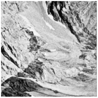
About the first thing Bert sent me was a 30 inch by 30 inch photographic enlargement (30X) of a satellite photo of the southern face of Mount Cilo and surrounding terrain which had been taken over three decades previously on September 24, 1968.[9] It was a superb research instrument for our purpose: the focus was sharp, the lighting was excellent, snow cover was minimal, and there was not a cloud in the sky.
Bert expressed some concern in the note he sent along with the photo. His concern was certainly justified. The summit of the mountain was rocky and jagged. (See Figure 2 for an illustration of the nature of the mountains in the vicinity of Mount Cilo.) It was difficult to see where anyone could park an ark up there. And it was difficult to imagine Mrs. Noah getting down from such a mountain. But then the Bible never said the ark settled down on a lovely, level field. And neither did it say that Mrs. Noah's role in the Flood adventure was all roses.
I began to pour over this photo, looking for anything odd or out of place which might possibly have been remains of the ark. There is a lot of visual learning which takes place whenever one first looks at one of these satellite photos. First it is necessary to figure out in which orientation the photo should be viewed. The shot is taken looking more or less straight down at the surface of the earth from great height. As a result there is no immediately obvious top or bottom of the photo. But the shot is seldom exactly straight down, which means there is one viewing angle for the photo in which is easier to "see" topographical features in proper perspective. Since one doesn't know, initially, what the surface one is looking at should look like, it takes a while to figure out what one is looking at and to get everything to make sense.
Eventually I emerged from this visual search exercise with two objects which didn't seem to fit immediately with their surroundings. Of these two, the second was by far the most interesting. It appeared as a barn-like structure not too far down from the summit of Mount Cilo. This is the object shown in Figure 1. We dubbed it "IO3", short for Interesting Object #3.
All effort has been focused on elucidating the true nature of IO3 since that initial discovery. Is it remains of the ark, or is it some natural feature of the surrounding terrain, or is it something else—like a military installation? Despite several years of deliberate effort, we still have no definite answers to these questions. We hope to obtain custom satellite photos of the south side of Cilo later this summer, which we are hoping will shed some definitive light on the matter. A modern photo should yield a definite answer to at least one question: Is IO3 still there in the same spot these 33 years after the Figure 1 image was taken? But the ability to answer even this question will depend on several uncontrollable factors, such as the depth of snow on the ground when the new photo is taken.
When I evaluate all the evidence we have on IO3 to the present time I feel it remains a strong candidate for the ark—certainly the best of any ark candidate I have ever seen or heard of. The only objective negative evidence we have at present is the fact that IO3 is about 60% larger than one would expect from the dimensions of the ark specified in Genesis 6:15, assuming a normal eighteen inch cubit. While this weakens the IO3 candidacy, it does not falsify it. Other cubits, longer than eighteen inches, were in use in the ancient past. We cannot be sure a normal, eighteen-inch cubit was used for this most ancient vessel.
Meanwhile, there are several positive evidences. I have discussed these in some detail previously, so I will be very brief here.[10] First, of course, is the apparent improbability of finding such a suitable object so close to the predicted landing place. The Biblical narrative leads to the expectation that the ark landed at or near the summit of its mountain, both because the mountain does not seem to have been sighted before the ark grounded on it, and because it was 72 days before any surrounding peaks became visible. I have no numbers on this, but I venture to suggest that if one had similar satellite photos of all the mountains in the Ararat region the frequency of barn-like objects near the summits of these mountains would be exceedingly low. Why should such a suitable object be found so near to the summit of this predicted mountain?
By far the most persuasive evidence, however, is that which comes from the satellite images themselves concerning the shape of this object. Bert was ultimately able to locate two satellite views of IO3, taken at different times and from different angles. These two views are shown at left in Figure 4. (These are meant to be viewed at arm's length, minimum.) To the right of each is shown a simulation photograph which I took, using cotton balls for snow and the scale model of the ark shown in the top photo. These simulation photos strongly support the idea that IO3 is shaped like the wooden model ark because it is not at all easy to get two dissimilar 3-dimensional objects to project such similar 2-dimensional images from two randomly chosen perspectives. The high degree of similarity evidenced in both perspectives in this particular case, though not proof, seems highly significant. Whatever IO3 may ultimately turn out to be, it seems to have a shape similar to the wooden model ark. Though I have seen a number of photos of ark candidates advanced by various investigators, nothing I have seen approaches this.
 |
The most direct way to find out if IO3 is the ark is to hike in to the site and take a close-up look. After obtaining permission to climb any mountain in Turkey but the traditional Mount Ararat, Tom Godfrey attempted such a hike last summer. Unfortunately, once in the country he was denied permission to proceed with his planned climb of Cilo by local Turkish authorities. This denial seems to stem from political conflict between the Kurds and the Turks in the region surrounding Cilo, making the mountain unsafe for hikers.
In the conclusion of my initial disclosure of the IO3-ark candidacy I wrote:[11]
I need to make it very clear that the research team is not claiming IO3 is Noah's ark at this stage. We are unable either to confirm or to refute the possibility that IO3 may be the ark based on the information (satellite photos) we presently have available. …The claim that an object is the ark can only be responsibly made after: 1. close-up (probably ground-based, on-site) photographs reveal an object which is suitable to the ark both inside and out, and 2. wood from such a visibly suitable structure has been shown by radiocarbon to date to within a few centuries prior to 3520±21 B.C. … Neither of these two conditions has yet been met with IO3 or any other object which has ever been advanced as a candidate for the ark.
These comments are still applicable at present—despite considerable time and effort invested by all members of the research team to bring the IO3 candidacy to a definite conclusion one way or the other. Presently we have two orders pending with a commercial satellite company for custom satellite photos of the south side of Mount Cilo. These photos are scheduled to be taken late this summer, when snow cover should be minimum. Whatever results are obtained from these photos will be published in The Biblical Chronologist at the earliest opportunity.
Though I never intended to get involved in a search for Noah's ark, and though I have spent many more hours on it than I would ever have guessed possible when I first got involved, I feel honored to be a part of such an effort. If it is a great privilege to be among the first to explore new frontiers, how much more so when those new frontiers bear so strongly on the vital issue of the historical reliability of Genesis. I look forward eagerly to whatever information may be forthcoming in regard to IO3 this summer. ◇
The Biblical Chronologist is a bimonthly subscription newsletter about Biblical chronology. It is written and edited by Gerald E. Aardsma, a Ph.D. scientist (nuclear physics) with special background in radioisotopic dating methods such as radiocarbon. The Biblical Chronologist has a threefold purpose: to encourage, enrich, and strengthen the faith of conservative Christians through instruction in Biblical chronology, to foster informed, up-to-date, scholarly research in this vital field within the conservative Christian community, and to communicate current developments and discoveries in Biblical chronology in an easily understood manner. An introductory packet containing three sample issues and a subscription order form is available for $9.95 US regardless of destination address. Send check or money order in US funds and request the "Intro Pack." The Biblical Chronologist (ISSN 1081-762X) is published six times a year by Aardsma Research & Publishing, 412 Mulberry St., Loda, IL 60948-9651. Copyright © 2001 by Aardsma Research & Publishing. Photocopying or reproduction strictly prohibited without written permission from the publisher.
|
|
^ Gerald E. Aardsma, A New Approach to the Chronology of Biblical History from Abraham to Samuel, 2nd ed. (Loda IL: Aardsma Research and Publishing, 1993).
^ Gerald E. Aardsma, "Noah's Flood at Elk Lake," The Biblical Chronologist 2.6 (November/December 1996): 1–13.
^ Gerald E. Aardsma, "Research in Progress," The Biblical Chronologist 2.4 (July/August 1996): 9–14.
^ John C. Whitcomb, Jr. and Henry M. Morris, The Genesis Flood (Philadelphia: The Presbyterian and Reformed Publishing Company, 1961), 242–243.
^ Genesis 8:4.
^ Gerald E. Aardsma, "Chronology of Noah's Flood," The Biblical Chronologist 3.1 (January/February 1997): 1–8.
^ Gerald E. Aardsma, "The Depth of Noah's Flood," The Biblical Chronologist 3.3 (May/June 1997): 1–10.
^ Gerald E. Aardsma, "Noah's Flood at Devon Island," The Biblical Chronologist 3.4 (July/August 1997): 1–16.
^ The satellite photo was an enlargement of a declassified military film. It was purchased from the U.S. Geological Survey EROS Data Center. The ordering identifier for the film was DS1048-1088DA045.
^ Gerald E. Aardsma, "Research in Progress," The Biblical Chronologist 5.3 (May/June 1999): 7–16.
^ Gerald E. Aardsma, "Research in Progress," The Biblical Chronologist 5.3 (May/June 1999): 16.