
| |
| Volume 13, Number 3 | March 14, 2023 |
To draw on a map the true path taken by the Israelites from Egypt to Canaan following the Exodus is not an easy undertaking for several reasons, some of which are discussed this issue. Last issue, I announced discovery of the location of Elim, made easy by the unique presence of non-indigenous date palms there both at the time of the Exodus and at present. The identification of Rephidim is a more complex matter.
I suggested that the biblical Rephidim was the modern Be'er Resisim over twenty-seven years ago in connection with the discovery that Mount Yeroham seemed to be the true Mount Sinai.
In fact, there is another settlement where Exodus pottery has been found which is a little less than a day's journey to the southwest of Mount Yeroham. It is known today as Be'er Resisim. The obvious phonetic similarity and other factors cause me to propose that Be'er Resisim is the Biblical Rephidim. I suggest that the combination of evidence from Resisim and Yeroham make a very strong case for their identification with Rephidim and Sinai.[1]
At the time, I was pretty new to biblical archaeology. I have no formal training in archaeology. I was trained as a chronologist, not an archaeologist. My Ph.D., earned eleven years previously, had been in nuclear physics, with application to radiometric dating methods such as radiocarbon dating. While I felt completely at home and at ease in regard to chronology, it was clear that I had yet a lot to learn about biblical archaeology. So my initial identification of Mount Sinai with the modern Mount Yeroham was necessarily tentative, and my accompanying, supporting identification of Rephidim with Be'er Resisim was necessarily similarly tentative.
In subsequent years, I went on to firm up the Yeroham–Sinai equivalence as time and opportunity allowed.[2] Time and opportunity have only now allowed me to get back to the Be'er Resisim–Rephidim equivalence.
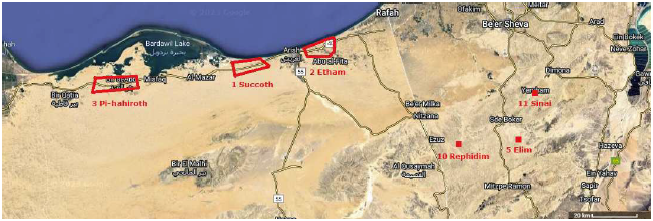
In the inaugural article for this series, published twenty-seven years ago, the locations of the first three encampments along the route of the Exodus were shown.[3] In Part II, published a month ago, archaeology at the third site, Etham, was used to deduce general characteristics of the Israelite encampments.[4] In Part III, last issue, the location of the fifth encampment site, Elim, was revealed.[5] This brought the total number of known Exodus encampment locations to six. These six are shown in Figure 1.
 |
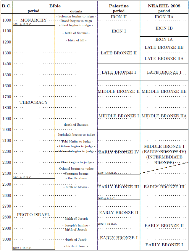
Assignment of these sites has been totally contingent on correct biblical chronology. Specifically, the 480 years of 1 Kings 6:1 in extant ancient manuscripts must be understood to have suffered loss of exactly 1000 years due to a very ancient copy error, so that the true chronology of all of biblical history prior to the time of Samuel is exactly 1000 years earlier than traditionally believed.[6] This places the date of the Exodus at 2447±12 B.C.
This date is shown in my 1995 correlation of biblical chronology with the secular archaeological chronology in Palestine (Figure 2, first three columns).[7] I have added a fourth column this issue, "NEAEHL 2008," to help guide us through the present discussion. It provides correlation with the chronology published in 2008 in The New Encyclopaedia of Archaeological Excavations in the Holy Land.[8] A photocopy of the relevant portion of the historical archaeological periods table from this volume is shown in Figure 3.
 |
 |
Correlating the biblical chronology date of the Exodus with the traditional archaeological period names in Palestine is necessary to be able to understand archaeological reports bearing on Exodus encampment sites. Unfortunately, this is a messy undertaking for several reasons, impeding progress.
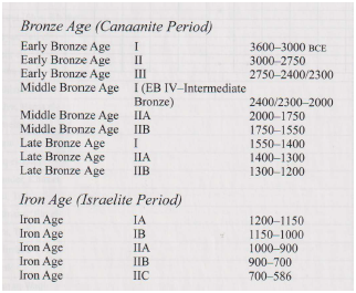
The first unavoidable messiness is the "MIDDLE BRONZE I (EARLY BRONZE IV) (INTERMEDIATE BRONZE)" period naming confusion shown in the fourth column of Figure 2. This is the "Middle Bronze Age I (EB IV–Intermediate Bronze)" of Figure 3. (I will abbreviate this to MBI-EBIV-IB from now on.) This messiness reflects the inability of archaeologists to come to a consensus for the name of this period. This sort of naming confusion occurs here (and only here) in this table because the biblical archaeologists are lost at sea in regard to the history which underlies this period. They are lost at sea because their biblical chronology prior to the Iron Age is a serious mess.
They started, several generations back, with a traditional biblical chronology which (mistakenly) placed the Exodus near 1450 B.C. and the Conquest near 1410 B.C. When it became clear through archaeological excavation that 1410 B.C. was not a functional date for the Conquest, they abandoned sound chronological principles (being, after all, archaeologists, not chronologists) and tried to date the Conquest by matching the archaeological landscape near 1410 B.C. to the biblical historical landscape of the Conquest. This predictably failed (the Conquest, in fact, having happened a full millennium earlier, nowhere near 1410 B.C.), but it moved the consensus of archaeological opinion (i.e., the biblical archaeological fad) toward ever more recent hypothetical dates for the Conquest. The "Israelite Period" shown in the chronological table of Figure 3 as beginning 1200 B.C. is the result of this date drift up to the time when the table was published in 2008.
This 1200 B.C. date for the start of the Israelie Period is entirely wrong and the method underlying it is wrongheaded. Chronology is no handmaiden of archaeology. Chronology must necessarily stand on its own two feet as a separate discipline from archaeology. Valid archaeological reconstructions are contingent on sound chronology, and not the other way around. This lesson was made abundantly clear by the advent of radiocarbon dating in the 1950's and the subsequent toppling of longstanding (then faddish) archaeological reconstructions it precipitated.
The lesson is no different in regard to biblical archaeology. Like radiocarbon, biblical chronology stands on its own feet apart from the discipline of biblical archaeology. And valid biblical archaeological reconstructions are contingent on sound biblical chronology, not the other way around.
Traditional biblical chronology said that the Exodus happened 1450 B.C. It was wrong. It had overlooked an accidentally dropped "thousand" years in 1 Kings 6:1. This biblical chronology error was corrected over thirty years ago.[9] Modern biblical chronology places the date of the Exodus 2450 B.C.
The world has been waiting now for over three decades for biblical archaeology to catch up to modern biblical chronology, but biblical archaeology still blunders heedlessly along. Forty years ago, the biblical chronology being used by biblical archaeologists was traditional biblical chronology, with the missing millennium in 1 Kings 6:1 not yet discovered. As a result, biblical archaeologists were lost at sea even back then in regard to the history underlying the MBI-EBIV-IB period.
If scholars cannot reach agreement on what name to give the period, it is because they still disagree on who these MBI people were. Were they local people, or were they an intrusive people, a people who migrated from elsewhere? If the latter, where did they come from and what was the path of their migration?[10]
At present, the biblical chronology being used by biblical archaeologists is an even worse mess, detached from sound biblical chronological procedure. Being lost at sea forty years ago, they determined to push further out to sea. As a result, they are now even more lost at sea. They still do not know who these MBI-EBIV-IB people were, and they still do not know where they came from—though the Bible provides multiple books telling us the answers to these questions in simple, plain, historical terms. (Special hints for the current generation of biblical archaeologists: The MBI-EBIV-IB people were the Israelites. They lived in tents. And they came from Egypt—one thousand years earlier than your discipline was originally expecting them.)
Now for a second point of messiness.
The biblical record of the historical events giving rise to the MBI-EBIV-IB period reveal that its true history is intrinsically messy.
According to the Bible, the Israelites enter the desert extending east of Egypt and south of Canaan roughly 2450 B.C., and they immediately begin to displace and conquer the indigenous Amalekites. This means that MBI-EBIV-IB has made a debut in this desert. This, however, is followed by a failed initial Conquest attempt of Canaan which puts further development of the MBI-EBIV-IB on pause for 40 years, during which time the Israelites did not prosecute their divinely appointed Conquest mission and remained in the desert (Numbers 14:26–35). The advent of MBI-EBIV-IB then resumes, with rapid Conquests Transjordan and then with a protracted Conquest of Canaan proper beginning at Jericho.
So the advent of MBI-EBIV-IB is itself historically messy. The Bible teaches us that it was a start–stop–start affair and that it did not happen everywhere at once in Canaan even when it was finally fully underway there.
To the archaeologists' credit, the messiness this history entails for the assignment of the date corresponding to the EBIII to MBI-EBIV-IB boundary is evinced in their table of Figure 3 by the spread of dates which occurs for that boundary (and only for that boundary)—"2400/2300"—spreading this transition out over a century (depicted as a sloped period boundary in Figure 2). But not to the biblical archaeologists' credit is their failure to see that this spread is itself a signature of the biblical historical record of the protracted Exodus/Conquest.
In any event, the Bible makes it clear that while the "Israelite Period" begins synchronous with the earliest advent of MBI-EBIV-IB remains in the northern Sinai Peninsula at Succoth, Etham, and Pi-hahiroth (not, good heavens, over a thousand years later with the start of the Iron Age), the destruction of EBIII urban civilization in Canaan, which defines the period boundary between EBIII and MBI-EBIV-IB, will not begin until forty years later.
Now for a third point of messiness.
The transition marking the coming of the Israelites into the Negev following the Exodus will appear as an EBII to MBI-EBIV-IB transition, not as an EBIII to MBI-EBIV-IB transition. This is because the archaeologists have messed up the assignment of EB phases in the Negev. This was pointed out a long time ago by one of their own, Rudolf Cohen,[11] but his attempted correction fell on deaf ears.
I attempted to amplify Cohen back at that time.[12]
But my attempted amplification has also fallen on deaf ears.[Cohen] noted that throughout southern Palestine EB IV (which he calls MB I) immediately follows EB II, with no apparent lapse of time between them. He explained that EB II is distinguished from EB III only by the absence of one particular type of pottery in EB II which is found in the north in EB III. He suggested that this type of pottery simply never penetrated into the south, thus causing what are really EB III remains to be misidentified as EB II.
Cohen's correction means that EBII in the Negev extends in time to the end of what is called EBIII elsewhere in Canaan. So the Conquest, in the Negev, will appear, archaeologically, to terminate EBII, while elsewhere in Canaan it will appear to terminate EBIII. (I didn't make this mess. I am just reporting on it.)
Now for a fourth point of messiness.
Cohen's designation, "The Mysterious MB I People" in the title of his archaeologically insightful article "The Mysterious MB I People—Does the Exodus Tradition in the Bible Preserve the Memory of Their Entry Into Canaan?" referenced above, is a fairly egregious misnomer, causing serious archaeological confusion.
Knowing what we know from the Bible, the MBI people are properly identified with the Israelites of the Exodus. Unfortunately, that's not what Cohen means by "The Mysterious MB I People." He means the people who were living in circular stone dwellings in the Negev during MBI-EBIV-IB. These people were not the Israelites. They were Midianites/Kenites.
Once again, it is necessary to pay attention to the Bible to get this right. Exodus 12:37–38 informs us that the Israelites left Egypt "about six hundred thousand men on foot, aside from children. And a mixed multitude also went up with them …" This seems to imply that not only Israelites but also some Egyptians participated in the Exodus, but this is not the important point at present. The important point is that the Israelites were subsequently joined at the encampment of particular interest this issue, Rephidim (encampment number 10), by a small group of Midianites/Kenites. These were related to Moses through his Midianite wife. This distinct ethnicity traveled with the Israelites from Rephidim onwards. I have discussed them in considerable detail previously.[13]
Now here is the critical point. The Israelites were a multitude, but they lived only in tents. Meanwhile, the Midianites/Kenites who traveled with them were a small clan of maybe a few dozen individuals, but they lived in circular stone buildings. Tents leave virtually no trace archaeologically while stone dwellings result in a long-lasting archaeological presence. So it is these Midianite/Kenite stone dwellings which tend to be the center of archaeological excavation and discussion, erroneously making their long-ago inhabitants "the MB I people" to the archaeologists. Consequently, the Israelites, who vastly outnumbered the Midianites/Kenites who accompanied them and who are responsible for the transition to MBI-EBIV-IB, have gotten left out of the archaeological story, while the small contingent of Midianites/Kenites who traveled with them have taken center stage with the archaeologists.
A fifth and final point of messiness impeding identification of route-of-the-Exodus encampments is that the Midianites/Kenites will show up archaeologically in two separate incursions into the Negev. The first incursion was when they traveled with the Israelites at the dawn of the MBI-EBIV-IB in the Negev, 2447±12 B.C. The second incursion will be late in the Conquest, probably starting no earlier than 2390 B.C., following not only the forty year interlude but also the death of Joshua (Judges 1:1).
And the descendants of the Kenite, Moses' father-in-law, went up from the city of palms with the sons of Judah, to the wilderness of Judah which is in the south of Arad; and they went and lived with the people. (Judges 1:16)This occupation of the Negev can be expected to have lasted roughly four centuries, to the end of the MBI-EBIV-IB period. This means, unfortunately, that the Midianite/Kenite circular stone dwellings cannot be taken as telltale markers of the route of the Exodus from Rephidim on. Some of the circular stone dwellings will be markers of that route, but many are expected to be from later in the MBI-EBIV-IB period.
The identification of the modern Be'er Resisim archaeological site with the biblical Rephidim rests on four lines of evidence. I will discuss these under the following headings:
Early Attractants,
Potential Falsifier,
Persuasive Proof, and
Easy Fit.
Early on, three things attracted attention to Be'er Resisim as a candidate for the biblical Rephidim. First was the report that Exodus pottery had been found there. Second was the phonetic similarity of Resisim and Rephidim. Third was the appropriate location of Be'er Resisim relative to Mount Yeroham/Sinai. I have discussed these previously,[14] so I will not belabor them here. Notice only that the addition of Elim to the Figure 1 map serves also to show that Be'er Resisim is in the right general geographical region.
There is a potential falsifier of the Be'er Resisim—Rephidim equivalence. This serves as a test of the Be'er Resisim—Rephidim equivalence hypothesis.
The biblical historical record of the Israelite encampment at Rephidim is fairly extensive. It occupies two chapters, Exodus 17 and Exodus 18. The narrative documents three distinct historical events. In chronological order these are:
the Israelites' acute need of water at the site, which Moses satisfied by striking a rock with his staff (Exodus 17:1–7),
a battle between the Israelites and the native Amalekites (Exodus 17:8–16), and
the arrival of Moses' Midianite/Kenite father-in-law, Jethro, bringing Moses' wife and two sons to him (Exodus 18:1–16).
This yields the condition that, if Be'er Resisim is indeed Rephidim, then there must be evidence of three distinct ethnicities there simultaneously: Israelites, Amalekites, and Midianite/Kenites.
Midianite/Kenite: Evidence of the Midianite/Kenites at Be'er Resisim in the MBI-EBIV-IB period is abundant. Their circular stone dwellings were the focus of the archaeological research at the site. The main group of such dwellings at Be'er Resisim is called "the settlement" or "the main settlement" by Dever, the reporting archaeologist.
The settlement … is situated in a small basin on a promontory below the 500-m contour.[15]
The Midianite/Kenites who accompanied the Israelites were copper workers. They did not mine or refine the copper. This was done elsewhere. Rather, they worked copper ingots into useful items such as daggers.
Particularly striking was the relatively high incidence of copper: pendants, awls, an intact dagger, and a hoard of several triangular ingots and a broken dagger, no doubt intended for resmelting.[16]
The MBI-EBIV-IB presence of Midianite/Kenites at Be'er Resisim is beyond question.
Amalekite: The evidence for Amalekites at Be'er Resisim is more muted, but is nonetheless present. From the introductory discussion above, these are to be expected as EBII remains. Framents of EBII pottery are present at the site:
There are also small groups of Early Bronze Age II sherds here and there on bedrock.[17]and also an EBII campsite:
On the other hand, site 126, high on the ridge to the southeast, was a small nomadic encampment from the Early Bronze Age II…[18]
Israelite: As discussed above, the tents of the Israelites are not very conspicuous archaeologically, so they tend to go unnoticed in modern archaeological surveys. Nonetheless, their MBI-EBIV-IB presence at Be'er Resisim is unambiguously attested by the broken remains of their pottery vessels—Exodus pottery—found there. In addition to this, there seems possibly to be a strong hint of a portion of their tent city at the site:
The investigation of both cultural and natural phenomena was extended beyond the main settlement at Be'er Resisim by several off-site surveys, but research was limited to an area of 4 square km [1.5 square miles]. An archaeological survey mapped nearly two hundred ancient features, more than 85 percent of them clusters of round houses, camps, burial cairns, or other installations belonging to the Middle Bronze Age I.[19]It has previously been shown that a typical Israelite encampment may be expected to occupy roughly 23 square miles.[20] The fact that the research area at Be'er Resisim was restricted to just 1.5 square miles means that the boundaries of the Israelite encampment there cannot be specified based upon the currently available archaeological data from the site. In addition, some of the nearly two hundred archaeological remains mapped within the 1.5 square miles which were surveyed will almost certainly belong to the later time, commencing with the late-Conquest occupation of the Negev by the tribe of Judah mingled with the Midianites/Kenites, discussed above. But the main signature of an Israelite encampment, as prototyped at the Etham encampment,[21] is expected to be a high density of archaeological remains over a large surface area. The 1.5 square mile survey appears to furnish the beginnings of such a signature.
Thus, the equivalence hypothesis passes this test. Evidences of all three of the biblically required ethnicities—Israelite, Amalekite, and Midianite/Kenite—are indeed found together at the right time at Be'er Resisim.
My research into the Be'er Resisim–Rephidim equivalence hypothesis led in an unexpected way to what seems to me to be as a near a proof of the hypothesis as one might hope for. This proof results from my investigation into the availability of water at the Be'er Resisim site. It is somewhat similar to the unique presence of date palms at the Ein Zik–Elim encampment, but it is broader than that simple proof. It springs from a unique geomorphology observed at Be'er Resisim, and it finds strong affirmation in the apparent solution of a difficult textual problem with the biblical Rephidim narrative which this geomorphology presents.
The ability to get water by striking a rock with a staff implies the presence of near-surface water, presumably dammed in some way by the rock. The geomorphology of Be'er Resisim uniquely exhibits this characteristic.
Be'er Resisim was located at precisely the one point along the wadi where the water-bearing shale layers rise to within 3 m [10 ft] of the surface. The modern well that gives its name to the site is located here, where even the shallow pits (tumili) dug by Bedouin can easily reach water.[22]
Today, according to the archaeologist, the shale is covered by 10 feet of alluvium. I suggest that this sediment has accumulated over top of the previously exposed shale layers due to silting up of the river bed as a result of reduced rainfall in the region since the time of the Exodus. The fact that the region received more rainfall at the time of the Exodus than it does today has been shown repeatedly.[23] A greater seasonal flow in the wadi than pertains today would have potential to flush these sediments out of the wadi down to bedrock.
To understand the significance of this observed water-bearing shale geomorphology to a correct understanding of the historical narrative, one has to know a little about ground water. Here is the most important thing to know in the present instance, taken from an introduction to the topic on the Internet:
Groundwater in aquifers between layers of poorly permeable rock, such as clay or shale, may be confined under pressure. If such a confined aquifer is tapped by a well, water will rise above the top of the aquifer and may even flow from the well onto the land surface. Water confined in this way is said to be under artesian pressure, and the aquifer is called an artesian aquifer.[24]
Artesian pressure results when water soaks into the ground at higher elevations (on hills, for example) and is subsequently trapped under impermeable layers at lower elevations (in valleys, for example). Nahal Resisim (i.e., the seasonal Resisim River) is flanked by hills. Meanwhile, its bed contains impermeable shale layers. This immediately suggests the possibility that it was water-bearing shale in the Nahal Resisim which Moses struck with his staff, fracturing it and allowing water trapped under artesian pressure to come out of it. If this is correct, then the miracle being recorded here is not that water was made to come from nowhere and flow out of a dry rock, but rather appears to be that God told Moses precisely where to find this water and how to get at it:
"Behold, I will stand before you there on the rock at Horeb; and you shall strike the rock, and water will come out of it, that the people may drink." (Exodus 17:6)This seems clearly to be saying that God (theophonically) will stand on the specific rock that Moses should strike.
This simple understanding of the narrative is complicated by the words "at Horeb." They make it appear that God is standing on a rock far away at Horeb (that is, at Mount Sinai, which is the modern Mount Yeroham). Recall that Sinai was the Israelites' next encampment site. The distance between Mount Yeroham and Be'er Resisim is about 40 km (25 miles) as the crow flies. The well at Resisim is down in the wadi (i.e., the dry river bed of the Resisim River) with hills on either side. There is no way Moses could even have seen God "at Horeb" from the wadi.
This leads me to suggest that the words "at Horeb" are a mistranslation of the original text. It is appropriate to make this suggestion because of the fact that these words make no sense at this point in the narrative. They make no sense not only in the present context, with Be'er Resisim as Rephidim and Mount Yeroham as Mount Sinai. They make no sense in any context. It makes no sense to strike a rock God is standing on located at the next encampment site to get water for the people to drink at the current encampment site.
In the present context, with Be'er Resisim as Rephidim, the rock—the shale—Moses is to strike is located in the dried up bed of the wadi. For an artesian aquifer, the shattering of the overlying shale would have allowed water to flow up through the rock and run, probably as a small rivulet, along the riverbed. So the verse seems simply to be saying, "Behold, I will stand before you there on the rock in the dried up wadi bed; and you shall strike the rock, and water will come out of it, that the people may drink." This implies that the words "at Horeb" should really be "in the dried up wadi bed."
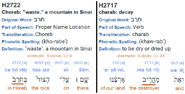
I am no Hebrew scholar, but I do know how to use a concordance. When I did so in this instance, via the Internet,[25] I was amazed to find that this suggested alternate reading works out rather well. When I looked up "Horeb" (H2722) in the concordance, I found that it comes from the root word H2717. When I turned to H2717, I found that this root word appears 40 times in the Bible, and that it is translated as "waste" 16 times, "dry" 7 times and "dry up" 7 times in the King James translation. Who would ever have guessed that the Hebrew word translated as "Horeb" should lead so directly to the ideas of "waste," "dry," and "dried up," all of which are suitably descriptive of a dried up wadi bed? Judging this to be a bit too coincidental, I dug into it further.[26]
To make a long story (Figure 4) short, it appears that H2717 and H2722, though pronounced differently, probably had identical spellings in the original manuscript, vowels being absent from ancient written Hebrew. This makes it possible that, somewhere along the line, someone simply began to use the wrong pronunciation and meaning. Such a mistake would have been easy to make because Horeb is a conspicuous part of the narrative of the Exodus encampments, bringing it quickly to mind when reading the narrative in Hebrew.
 |
Be'er Resisim is found uniquely and easily to fit the biblical record of the water-from-the-rock historical event at Rephidim, persuasively identifying Be'er Resisim as the location of the Israelite Rephidim encampment. But the water-from-the-rock incident is not the only part of the biblical narrative of the Israelite stay at Rephidim for which this is true. Be'er Resisim also provides an easy fit to the narrative of the battle with the Amalekites.
The biblical record of the battle informs us that Amalek was the aggressor and that Joshua was the Israelite general in charge of the Israelite defense. Moses interceded with God throughout the battle from the top of an overlooking hill. The site of intercession seems to have been marked by Moses with an altar following the battle.
Then Amalek came and fought against Israel at Rephidim. So Moses said to Joshua, "Choose men for us, and go out, fight against Amalek. Tomorrow I will station myself on the top of the hill with the staff of God in my hand." … So it came about when Moses held his hand up, that Israel prevailed, and when he let his hand down, Amalek prevailed. … So Joshua overwhelmed Amalek and his people with the edge of the sword. … And Moses built an altar, and named it The Lord is My Banner;… (Exodus 17:8–9, 15)All of this works out well at Be'er Resisim.
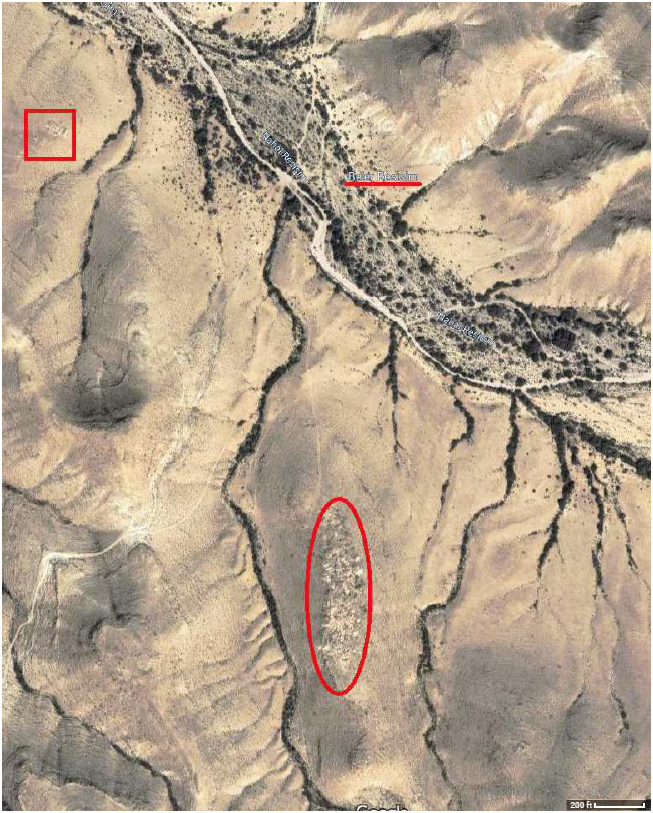
The holy place established by Moses' altar seems to have been preserved by the subsequent occupants of Be'er Resisim.
Two large rectangular buildings, both perched dramatically on the high ridges overlooking the main site, were empty, but parallels elsewhere suggest that they may be Early Bronze Age or Middle Bronze Age I sanctuaries.[27]The location of these two rectangular buildings is shown in Figure 5 inside the red square. They are situated on a hill overlooking the bed of the Resisim river below. This dried bed seems likely to have been the scene of the battle, with Israel camped probably downstream along the riverbed to the northwest (off the top of the map) and Amalek coming for battle from the opposite direction, up the riverbed from the southeast. The "main settlement" would not have been present at the time of the battle.
 |
It seems, tactically, that control of the newly established source of water would probably have been the objective of the battle. If the Amalekites could keep the Israelites and their herds from getting at this water, they would defeat the Israelites by thirst and dehydration. The biblical record of the battle naturally reads as a sort of seesaw contest, alternating between when "Amalek prevailed" and when "Israel prevailed." This finds a natural explanation as alternating possession and control of this water source by the two armies throughout the course of the battle.
The stay at Rephidim was brief. It is bracketed by the Israelites' departure from Elim (encampment number 5) "on the fifteenth day of the second month after their departure from the land of Egypt" (Exodus 16:1) and their arrival at Sinai: "In the third month after the sons of Israel had gone out of the land of Egypt, on that very day they came into the wilderness of Sinai" (Exodus 19:1). Since these would have been lunar months, and lunar months are about 29.5 days long, this encompasses just over two weeks. Between Elim and Sinai there were five encampments, of which Rephidim was the last. This averages to roughly three days per encampment.
This would have been a somewhat brutal pace, especially for the very aged and the very young. The early morning disassembly of one's household tent and campsite, the packing of tent and clothes and pots and tools and food and water for transport hour after hour across miles of overheated desert, and then the weary re-establishment of one's campsite at the new location late in the day, may have seemed fun for one or two moves, but would surely have grown old by Rephidim. To arrive at Rephidim and find no water at the site would not have been a small trial, and I suspect that most of us would have done poorly with it.
The rapid turnover of encampments seems to imply a lack of adequate resources—especially water and pasture—for long-term stay at any given site. Keeping ahead of sanitation may also have been a factor.
The arrival of Moses' in-laws, the Midianite/Kenites, may have been the critical factor freeing the Israelites from this gruelling pace. Their arrival marks a turning point. After Rephidim, the Israelites would travel to Sinai, where they would stay for nearly a year.
The Midianites/Kenites were, unlike the Israelites, a nomadic people, as their round houses testify:
The preference of curvilinear rather than rectilinear dwellings has been shown by cross-cultural and ethnographic studies to be typical of mobile, as opposed to sedentary, groups.[28]This means that they knew how to camp and they knew where to camp. It seems possible that advice from Moses' in-laws motivated the move to Sinai from Rephidim. That they were valued by Moses for just this sort of advice is seen explicitly, later in the narrative, when they set out from the Sinai encampment site:
Then Moses said to Hobab the son of Reuel the Midianite, Moses' father-in-law, "We are setting out to the place of which the Lord said, 'I will give it to you'; come with us and we will do you good, for the Lord has promised good concerning Israel." But he said to him, "I will not come, but rather will go to my own land and relatives." Then he said, "Please do not leave us, inasmuch as you know where we should camp in the wilderness, and you will be eyes for us." (Numbers 10:29–31)(The "you will be eyes for us" phrase finds ready explanation in the Midianite/Kenite practice of perching their settlements high on an easily defended, steep hill, as their settlement in Figure 5 is seen to be situated. This made their settlements natural lookout posts.)
One final thought: the modern well at Be'er Resisim may mark the very location where Moses struck the rock (i.e., the water-bearing shale). Once the site of subsurface water had been Divined (I am deliberately capitalizing the word "divined" in this instance to show that I am not talking about discovering water by dowsing but rather about discovering water by God revealing where it is—Exodus 17:6) and the artesian flow of water there established by Moses, it would have been natural for later native Negev desert inhabitants to protect this valuable water source as aridity increased and wadi alluvium deepened in ensuing millennia. The modern well may be merely the latest refurbishing of the original water source opened at the same spot by Moses 2450 B.C. ◇
The Biblical Chronologist is written and edited by Gerald E. Aardsma, a Ph.D. scientist (nuclear physics) with special background in radioisotopic dating methods such as radiocarbon. The Biblical Chronologist has a fourfold purpose: to encourage, enrich, and strengthen the faith of conservative Christians through instruction in biblical chronology and its many implications, to foster informed, up-to-date, scholarly research in this vital field, to communicate current developments and discoveries stemming from biblical chronology in an easily understood manner, and to advance the growth of knowledge via a proper integration of ancient biblical and modern scientific data and principles. The Biblical Chronologist (ISSN 1081-762X) is published by: Aardsma Research & Publishing Copyright © 2023 by Aardsma Research & Publishing. Scripture quotations taken from the (NASB®) New American Standard Bible®, Copyright© 1960, 1971, 1977, 1995 by The Lockman Foundation. Used by permission. All rights reserved. www.Lockman.org |
^ Gerald E. Aardsma, "Yeroham—The True Mt. Sinai?" The Biblical Chronologist 1.6 (November/December 1995): 8. www.BiblicalChronologist.org.
^ Gerald E. Aardsma, "The Bamah of Moses at Mount Sinai," The Biblical Chronologist 6.3 (May/June 2000): 1–10. www.BiblicalChronologist.org. Gerald E. Aardsma, "Yeroham: the True Mount Sinai," The Biblical Chronologist 6.4 (July/August 2000): 1–11. www.BiblicalChronologist.org. Gerald E. Aardsma, "Report on the Excursion to Mt. Yeroham – Part I," The Biblical Chronologist 6.5 (September/October 2000): 1–13. www.BiblicalChronologist.org. Gerald E. Aardsma, "Report on the Excursion to Mt. Yeroham – Part II," The Biblical Chronologist 6.6 (November/December 2000): 1–10. www.BiblicalChronologist.org. Gerald E. Aardsma, "Report on the Excursion to Mt. Yeroham – Part III," The Biblical Chronologist 7.1 (January/February 2001): 1–16. www.BiblicalChronologist.org. Gerald E. Aardsma, "The Crater at Mt. Yeroham – Part I," The Biblical Chronologist 9.1 (May 2008): 1–7. www.BiblicalChronologist.org.
^ Gerald E. Aardsma, "The Route of the Exodus," The Biblical Chronologist 2.1 (January/February 1996): 1–9. www.BiblicalChronologist.org.
^ Gerald E. Aardsma, "The Route of the Exodus, Part II: The Encampment at Etham," The Biblical Chronologist 13.1 (February 7, 2023): 1–5. www.BiblicalChronologist.org.
^ Gerald E. Aardsma, "The Route of the Exodus, Part III: The Location of Elim," The Biblical Chronologist 13.2 (February 16, 2023): 1–4. www.BiblicalChronologist.org.
^ Gerald E. Aardsma, A New Approach to the Chronology of Biblical History from Abraham to Samuel, 2nd ed. (Loda, IL: Aardsma Research and Publishing, 1995). www.BiblicalChronologist.org. Gerald E. Aardsma, "Evidence for a Lost Millennium in Biblical Chronology," Radiocarbon 37.2 (1995): 267–273.
^ Gerald E. Aardsma, "The Chronology of Palestine in Relation to the Bible: 3000–1000 B.C.," The Biblical Chronologist 1.4 (July/August 1995): 1–6. www.BiblicalChronologist.org.
^ 'Ephraim Stern, editor, "Chronological Tables," The New Encyclopaedia of Archaeological Excavations in the Holy Land, vol. 5 (Jerusalem: The Israel Exploration Society, 2008), 2126.
^ Gerald E. Aardsma, A New Approach to the Chronology of Biblical History from Abraham to Samuel, 2nd ed. (Loda, IL: Aardsma Research and Publishing, 1995). www.BiblicalChronologist.org. Gerald E. Aardsma, "Evidence for a Lost Millennium in Biblical Chronology," Radiocarbon 37.2 (1995): 267–273.
^ Rudolph Cohen, "The Mysterious MB I People—Does the Exodus Tradition in the Bible Preserve the Memory of Their Entry Into Canaan?" Biblical Archaeology Review 9.4 (1983): 18.
^ Rudolph Cohen, "The Mysterious MB I People—Does the Exodus Tradition in the Bible Preserve the Memory of Their Entry Into Canaan?" Biblical Archaeology Review 9.4 (1983): 16–29.
^ Gerald E. Aardsma, A New Approach to the Chronology of Biblical History from Abraham to Samuel, 2nd ed. (Loda, IL: Aardsma Research and Publishing, 1995), 91. www.BiblicalChronologist.org.
^ Gerald E. Aardsma, "The Bamah of Moses at Mount Sinai," The Biblical Chronologist 6.3 (May/June 2000): 3–6. www.BiblicalChronologist.org. Gerald E. Aardsma, "Yeroham: the True Mount Sinai," The Biblical Chronologist 6.4 (July/August 2000): 10–11. www.BiblicalChronologist.org.
^ Gerald E. Aardsma, "Yeroham—The True Mt. Sinai?" The Biblical Chronologist 1.6 (November/December 1995): 8. www.BiblicalChronologist.org.
^ William G. Dever, "Be'er Resisim," The New Encyclopaedia of Archaeological Excavations in the Holy Land, vol. 1 (New York: Simon & Schuster, 1993), 158.
^ William G. Dever, "Be'er Resisim," The New Encyclopaedia of Archaeological Excavations in the Holy Land, vol. 1 (New York: Simon & Schuster, 1993), 159.
^ William G. Dever, "Be'er Resisim," The New Encyclopaedia of Archaeological Excavations in the Holy Land, vol. 1 (New York: Simon & Schuster, 1993), 159.
^ William G. Dever, "Be'er Resisim," The New Encyclopaedia of Archaeological Excavations in the Holy Land, vol. 1 (New York: Simon & Schuster, 1993), 159.
^ William G. Dever, "Be'er Resisim," The New Encyclopaedia of Archaeological Excavations in the Holy Land, vol. 1 (New York: Simon & Schuster, 1993), 159.
^ Gerald E. Aardsma, "The Route of the Exodus, Part II: The Encampment at Etham," The Biblical Chronologist 13.1 (February 7, 2023): 3. www.BiblicalChronologist.org.
^ Gerald E. Aardsma, "The Route of the Exodus, Part II: The Encampment at Etham," The Biblical Chronologist 13.1 (February 7, 2023): 1–5. www.BiblicalChronologist.org.
^ William G. Dever, "Be'er Resisim," The New Encyclopaedia of Archaeological Excavations in the Holy Land, vol. 1 (New York: Simon & Schuster, 1993), 159–160.
^ Gerald E. Aardsma, "The Route of the Exodus, Part III: The Location of Elim," The Biblical Chronologist 13.2 (February 16, 2023): 3. www.BiblicalChronologist.org.
^ usgs.gov/special-topics/water-science-school/science/ aquifers-and-groundwater (accessed March, 2, 2023).
^ I used the Strong's Concordance utility at bible.knowing-jesus.com (accessed March, 3, 2023).
^ I am much indebted to Tom Godfrey for help with the question of what might have happened to cause an original reading of "in the dried up wadi bed" to become "at Horeb" discussed in this paragraph. To this question, Tom replied (personal communication, March 8, 2023):
I should disclose that I lack the credentials of a real expert in Hebrew, either ancient or modern. In the summer of 1974, I took the equivalent of two semesters of Hebrew while I was a graduate student in linguistics at The University of Texas at Austin. I did this to satisfy a degree requirement for at least elementary knowledge of a non-Indo-European language. My instructors were native speakers of Modern Hebrew. That summer, they included a brief study of Genesis 1. I am convinced that even an elementary command of Hebrew is sufficient to make the brilliant point you want to make. …
To summarize, it is possible that a copy error was involved, but later scholars may have guessed how the written letters were supposed to be pronounced and possibly guessed wrong. It all depends on what matres lectionis [consonant letters used to represent vowel sounds in Hebrew] were involved, if any, in the most ancient manuscripts. I think you have a strong case for the reading you proposed, but you may want to double check with a real expert in Hebrew. …
Another point in support of your case for rejecting the "Horeb" reading is the fact that our Hebrew texts do not include any mater lectionis in the word of interest. This may or may not be because there wasn't any in the original manuscripts either, but if the originals had consonants only, there may well have been periods when original pronunciations were not transmitted faithfully in rare cases of ambiguity.
^ William G. Dever, "Be'er Resisim," The New Encyclopaedia of Archaeological Excavations in the Holy Land, vol. 1 (New York: Simon & Schuster, 1993), 159.
^ William G. Dever, "Be'er Resisim," The New Encyclopaedia of Archaeological Excavations in the Holy Land, vol. 1 (New York: Simon & Schuster, 1993), 159.