
| |
| Volume 13, Number 4 | March 28, 2023 |
"I have returned."
—General Douglas MacArthur
October 20, 1944
This issue goes to press with a great deal of satisfaction. It fulfills an objective I expressed in this research newsletter over 27 years ago and which I have carried with me ever since.[1]
In the context in which this was written, an interval of 27 years does not qualify as "the near future." As it turned out, other, higher priority items—especially the discovery of the cause and cure of aging,[2] hidden beyond the horizon at that time—intervened, stalling this particular battle decades longer than anticipated. But now, at long last, my "I-have-returned" moment has come.A site which is strongly connected with the wilderness wandering which I have not discussed until now is Kadesh-barnea. I illustrated the uncertainty which presently surrounds the route the Israelites took when they left Egypt and journeyed to Palestine… by plotting a variety of suggested starting points, routes across the Sinai, and locations of Mount Sinai. In contrast to these uncertainties, scholars seem pretty confident about the location of Kadeh-barnea—there seems little divergence of opinion on this one site at least. …
Unfortunately, the accepted location of Kadesh-barnea and the location I have just shown for Mount Sinai are in serious conflict. Mount Yeroham is but a day and a half from the accepted location of Kadesh-barnea, while Deuteronomy 1:2 is quite clear that "It is eleven days' journey from Horeb [i.e., Sinai] by the way of Mount Seir to Kadesh-barnea."
But that is another long story, and there is insufficient space to embark upon it here. Perhaps I will have opportunity to show you where I believe Kadesh-barnea is really located in another issue in the near future.
Deuteronomy 1:2 is the big clue to the location of Kadesh-barnea. It tells us both the direction one must head from Sinai to get there and the overall walking distance.
It is eleven days' journey from Horeb [i.e., Mount Sinai] by the way of Mount Seir to Kadesh-barnea. (Deuteronomy 1:2)
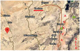
Evidently, the path from Mount Sinai to Kadesh-barnea passes by Mount Seir. Mount Seir appears, biblically, to be located on the east side of the Arava valley which lies south of the Dead Sea (Figure 1). This implies that the biblical Kadesh-barnea cannot be located to the west of Mount Sinai, for one must walk eastward to get from Mount Sinai to Mount Seir. So the current consensus site for Kadesh-barnea, located southwest of Mount Sinai, is wrong not only in regard to the walking distance between it and Sinai but also in regard to its direction relative to Sinai.
 |
Further evidence that the current consensus site is mistaken seems provided by the lack of evidence for any occupation there at the time of the Exodus, 2450 B.C. This date corresponds to earliest Middle Bronze I (also called Early Bronze IV or Intermediate Bronze), and the archaeologists report no evidence of occupation at the current consensus site during this time period.[3]
But the current consensus site is not the only exclusion from the biblical Kadesh-barnea. The whole of modern-day Israel appears to be excluded. Two lines of evidence lead to this conclusion.
First, an eleven-day journey from Mount Sinai (Mount Yeroham) in any direction is likely to take one well beyond the borders of modern-day Israel. Only a seriously contorted, indirect path could remain within its borders. The distance which could be traveled by the Israelites in an eleven days' journey can be estimated using Rephidim (Be'er Resisim) and Sinai (Yeroham). Rephidim was the tenth encampment and Sinai was the eleventh, so Rephidim appears to be a one-day journey from Sinai. Last issue I noted: "The distance between Mount Yeroham and Be'er Resisim is about 40 km (25 miles) as the crow flies."[4] This gives only a minimum distance between these two encampments, of course. One can not easily walk in a straight line from Be'er Resisim to Yeroham because the terrain involves hills and canyons. So the minimum distance between Sinai and Kadesh-barnea will be (40 × 11 =) 440 km (275 miles).
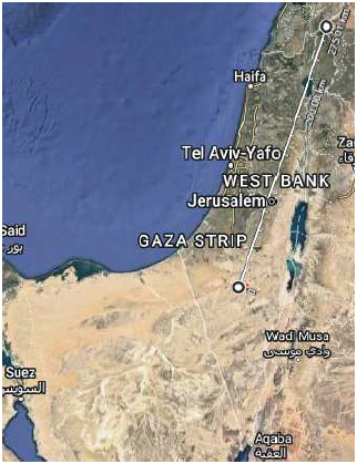
Figure 2 shows that the straight-line distance from Mount Yeroham to the farthest-away border of modern-day Israel, in the northeast corner of the country, is just 275 km (170 miles), less than two-thirds of the minimum distance from Mount Sinai to Kadesh-barnea.
 |
Second, if Kadesh-barnea were located inside the borders of modern-day Israel, Israeli archaeologists would have made it unambiguously identifiable long ago by discovery of the great abundance of Exodus pottery which must exist there.
I have previously discussed and shown examples of the remarkable abundance of Exodus pottery which exists on the plain at the foot of Mount Sinai (the modern Mount Yeroham).[5] The Israelites camped there for a single year. The Israelites camped at Kadesh-barnea for nearly forty years. The true site of the biblical Kadesh-barnea should be easily identifiable by the presence of a greater abundance of Exodus pottery there than anywhere else.
Modern-day Israel seems significantly ahead of its neighbors in regard to expenditure of resources on archaeology, both in research discovery and in publication. While it seems impossible that the true site of Kadesh-barnea could lie hidden somewhere in modern-day Israel, that it may lie hidden outside the borders of modern-day Israel seems entirely possible.
The minimum distance which could be covered by the Israelites in eleven days has been estimated above as 440 km (275 miles). What is a reasonable maximum distance?
This may be estimated fairly simply. Thirty miles per day is generally regarded as the upper limit for walking. This yields a maximum distance from Mount Yeroham to Kadesh-barnea of (30 × 11 =) 330 miles (530 km).
Summarizing, the distance from Mount Yeroham to the biblical Kadesh-barnea is expected to be between 440 and 530 km (275 and 330 miles).
As shown in Figure 1, according to Deuteronomy 1:2, to get to Kadesh-barnea from Mount Sinai by way of Mount Seir, it is first necessary to travel eastward from Yeroham to the Arava valley, and then southward along the Arava valley. Mount Seir will then be on the left.
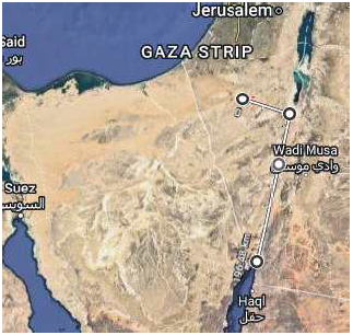
As seen in Figure 3, continuing south along the Arava valley leads ultimately to the tip of the Gulf of Aqaba at about 196 km (122 miles) from Yeroham, leaving a minimum of yet another 244 km (153 miles) to go to get to Kadesh-barnea.
 |
One must veer either west into the Sinai Peninsula, or east into modern-day Jordan at this point. For the Israelites, this choice would have been dictated by regional climate.
The Israelites' desert economy, necessary for their survival, required two things: 1) sufficient pasture for their vast herds of livestock, and 2) a sodic desert soil to guarantee manna production.[6] These two requirements defined a fairly narrow climatic zone in which the Isrelites could camp. It could not be too arid or there would be too little vegetation for the herds. It could not be too moist or the sodium salts needed for the production of manna would be washed too deeply into the soil profile for manna production to occur.
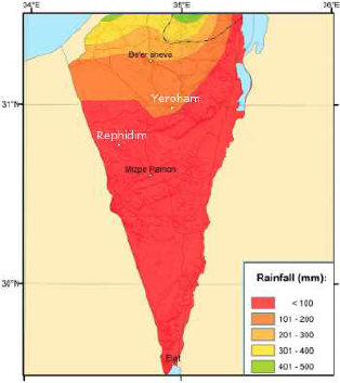
Figure 4 shows a map of average annual rainfall for Israel.[7] It is clear from this figure that aridity increases from north to south. Annual rainfall at Yeroham today may be estimated as slightly more than 100 mm by its situation near the 100 mm dividing line between the red and orange zones. Annual rainfall further south at Rephidim is clearly less. Yet further south, at Mizpe Ramon, it has dropped to 67 mm.[8] Down in the extreme south of Israel, at Eilat, it has dropped to 49 mm.[9]
 |
As the Israelites traveled from Sinai south, on their way to Kadesh-barnea, they were moving into increasingly arid desert—too arid to support their livestock for any length of time. When they reached the tip of the Gulf of Aqaba, they would need to veer in the direction of decreasing aridity.
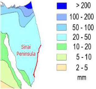
Figure 5 shows the average annual rainfall to the west of Israel.[10] (Each map uses its own rainfall ranges and color scheme, so it is necessary to focus on each map individually.) This map shows that aridity increases as one travels west. It is immediately clear that the Israelites would not have veered west into the Sinai Peninsula once they had reached the Gulf of Aqaba. To do so would have taken them into increasingly arid desert, completely unsuited to long-term encampment.
 |
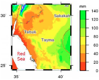
This leaves the region to the east as the only possibility. Figure 6 shows that as one moves southeast from the tip of the Gulf of Aqaba the overall trend is toward deceasing aridity, as needed.[11]
 |
Because a significant portion of the eleven-days' journey to Kadesh-barnea yet remained once the Israelites had reached the tip of the Gulf of Aqaba, we may safely conclude, at this point, that the biblical Kadesh-barnea is located somewhere in Saudi Arabia.
The location of Kadesh-barnea in Saudi Arabia may be narrowed down fairly precisely based on two considerations. First, Kadesh-barnea must be located eleven-days' journey from Mount Sinai. Second, it must be located where abundant near-surface water exists.
This second requirement follows from the biblical record of events at Kadesh-barnea. Specifically, it was at Kadesh-barnea that the second water-from-the-rock incident occurred.
Then the sons of Israel, the whole congregation, came to the wilderness of Zin in the first month; and the people stayed at Kadesh. …
And there was no water for the congregation; and they assembled themselves against Moses and Aaron. The people thus contended with Moses and spoke, saying, "If only we had perished when our brothers perished before the Lord! Why then have you brought the Lord's assembly into this wilderness, for us and our beasts to die here? And why have you made us come up from Egypt, to bring us in to this wretched place? It is not a place of grain or figs or vines or pomegranates, nor is there water to drink!" Then Moses and Aaron came in from the presence of the assembly to the doorway of the tent of meeting, and fell on their faces. Then the glory of the Lord appeared to them; and the Lord spoke to Moses, saying, "Take the rod; and you and your brother Aaron assemble the congregation and speak to the rock before their eyes, that it may yield its water. You shall thus bring forth water for them out of the rock and let the congregation and their beasts drink."
So Moses took the rod from before the Lord, just as He had commanded him; and Moses and Aaron gathered the assembly before the rock. And he said to them, "Listen now, you rebels; shall we bring forth water for you out of this rock?" Then Moses lifted up his hand and struck the rock twice with his rod; and water came forth abundantly, and the congregation and their beasts drank. (Numbers 20:1–11)
We saw last issue that, at Rephidim (Be'er Resisim), water flowed from the (shale) rock in the wadi at Be'er Resisim when it was struck, because of the unique presence there of an underground artesian aquifer.[12] Striking the shale capping the artesian aquifer fractured the shale, allowing trapped, pressurized water to flow up through the shale.
The same sort of phenomenon appears to be involved at Kadesh-barnea, only this time, water flowed from the shattered rock "abundantly." This suggests the presence of a much larger artesian aquifer at Kadesh-barnea than at Be'er Resisim.
Since Kadesh-barnea, like Rephidim, was located in the desert, we may expect this new water source to have been maintained and developed by subsequent inhabitants down into modern times, just as was seen to be the case at Be'er Resisim.
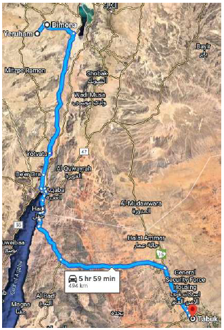
The modern city of Tabuk, in Saudi Aarbia, has both the right driving distance from Yeroham and a large underground aquifer. The driving distance from Mount Yeroham to Tabuk is 494 km (Figure 7), roughly half way between the minimum and maximum distances of 440 and 530 km calculated above. When we zoom in on Tabuk in Google Maps, we see immediate evidence of abundantly available subsurface water (Figure 8).
 |
Today, the Tabuk region is naturally, like the Yeroham (Sinai) region, mostly bare-earth desert. But we have repeatedly seen that the region containing the Dead Sea, Yeroham and other earlier encampments was less arid, and hence more vegetated, back at the time of the Exodus than it is today. It is reasonable to expect that this regionally reduced aridity extended also to Tabuk, yielding suitable long-term pasturage there as at Yeroham.
To the best of my knowledge, no one has ever previously proposed that the biblical Kadesh-barnea should be located at or near Tabuk, Saudi Arabia. But, of course, this has also been true of the six other encampments which have been previously identified in this research newsletter series on the route of the Exodus.
Regardless, as it seems altogether too coincidental that Tabuk should be both at the right distance from Mount Sinai and have a large underground aquifer in the middle of otherwise dry desert, and as, when following the biblically prescribed path from Sinai "by the way of Mount Seir," no other location appears to satisfy these two requirements of right distance and subsurface water, it seems that it may be concluded with considerable confidence that the modern city of Tabuk marks at least the vicinity and likely the very location of the biblical Kadesh-barnea, encampment 32. Further strengthening this location is the fact that the path to Tabuk from Sinai passes naturally through the traditional Ezion-geber, encampment 31, near modern Aqaba at the tip of the Gulf of Aqaba. That it totally upends the current concensus site of Arad—well, that is another long story… ◇
The Biblical Chronologist is written and edited by Gerald E. Aardsma, a Ph.D. scientist (nuclear physics) with special background in radioisotopic dating methods such as radiocarbon. The Biblical Chronologist has a fourfold purpose: to encourage, enrich, and strengthen the faith of conservative Christians through instruction in biblical chronology and its many implications, to foster informed, up-to-date, scholarly research in this vital field, to communicate current developments and discoveries stemming from biblical chronology in an easily understood manner, and to advance the growth of knowledge via a proper integration of ancient biblical and modern scientific data and principles. The Biblical Chronologist (ISSN 1081-762X) is published by: Aardsma Research & Publishing Copyright © 2023 by Aardsma Research & Publishing. Scripture quotations taken from the (NASB®) New American Standard Bible®, Copyright© 1960, 1971, 1977, 1995 by The Lockman Foundation. Used by permission. All rights reserved. www.Lockman.org |
^ Gerald E. Aardsma, "Yeroham—The True Mt. Sinai?" The Biblical Chronologist 1.6 (November/December 1995): 8. www.BiblicalChronologist.org.
^ Gerald E. Aardsma and Matthew P. Aardsma, Aging: Cause and Cure, 2nd ed. (Loda, IL: Aardsma Research and Publishing, 2021). www.BiblicalChronologist.org.
^ Isaac Gilead, "Kadesh-barnea: The Prehistoric Sites," The New Encyclopaedia of Archaeological Excavations in the Holy Land, vol. 3 (New York: Simon & Schuster, 1993), 841–843. Rudolf Cohen, "Kadesh-barnea: The Israelite Fortress," The New Encyclopaedia of Archaeological Excavations in the Holy Land, vol. 3 (New York: Simon & Schuster, 1993), 843–847.
^ Gerald E. Aardsma, "The Route of the Exodus, Part IV: The Identification of Rephidim," The Biblical Chronologist 13.3 (March 14, 2023): 9. www.BiblicalChronologist.org.
^ Gerald E. Aardsma, "Report on the Excursion to Mt. Yeroham – Part III," The Biblical Chronologist 7.1 (January/February 2001): 9–12. www.BiblicalChronologist.org.
^ Gerald E. Aardsma, Bread from Heaven: The Manna Mystery Solved (Loda, IL: Aardsma Research and Publishing, 2023), Appendix A. www.BiblicalChronologist.org.
^ This figure has been constructed from a larger original figure found at www.researchgate.net/figure/Mean-annual-rainfall-mm-in-various-regions-in-Israel-and-the-Palestinian-Authority-from_fig6_320288188 (accessed March 22, 2023).
^ weather-and-climate.com/average-monthly-precipitation-Rainfall,mitzpe-ramon-south-district-israel-il,Israel (accessed March 22, 2023).
^ weather-and-climate.com/average-monthly-Rainfall-Temperature-Sunshine,Eilat,Israel (accessed March 23, 2023).
^ www.researchgate.net/figure/Annual-precipitation-in-Sinai_fig3_228468774 (accessed March 22, 2023).
^ This figure has been constructed from a larger original figure found at www.juancole.com/2010/12/saudi-arabia-distribution-of-annual-rainfall.html (accessed March 22, 2023).
^ Gerald E. Aardsma, "The Route of the Exodus, Part IV: The Identification of Rephidim," The Biblical Chronologist 13.3 (March 14, 2023): 8–11. www.BiblicalChronologist.org.