
| |
| Volume 13, Number 5 | June 13, 2023 |
Marah is the fourth Israelite encampment site following the Exodus from Egypt.
Prior to Marah, the Israelites had stayed on the North Sinai road. They had left Egypt as slaves on a religious holiday, evicted temporarily and grudgingly by Pharaoh Merenre Antyemsaph[1] II (Exodus 12:30–32).
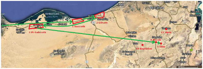
They had come out of Egypt along the North Sinai road, stopping first at Succoth, then moving farther east along the North Sinai road to camp on the edge of the wilderness at Etham.
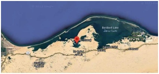
Then, under God's direction through Moses, they had turned back west toward Egypt on the North Sinai road to camp in front of the modern-day Ar Ruwaj—the biblical Red/Reed Sea—a lagoon of the larger modern-day Bardawil Lake (Figure 1). This was their third encampment. They called it Pi-hahiroth.
 |
There shortly followed the destruction of the army of Egypt by the trapping and drowning of Merenre Antyemsaph II and his soldiers in Ar Ruwaj consequent to the well-known Red/Reed Sea crossing incident.
The Israelites, now freemen for the first time in hundreds of years, left the North Sinai road at this point and struck off across the adjacent desert. Having been permanently freed of the Egyptian menace, they would spend the next year getting the new nation organized and readied for the Conquest of the Promised Land in the relative peace and protection of the sparsely populated central Negev desert.
Then Moses led Israel from the Red Sea [literally: Sea of Reeds], and they went out into the wilderness of Shur; and they went three days in the wilderness and found no water. And when they came to Marah, they could not drink the waters of Marah, for they were bitter [Hebrew: Marim]; therefore it was named Marah [Bitterness]. So the people grumbled at Moses, saying, "What shall we drink?" Then he cried out to the Lord, and the Lord showed him a tree; and he threw it into the waters, and the waters became sweet. (Exodus 15:22–25a.)
Reading this as a boy, I assumed that the tree somehow desalinated the water. I thought the tree must have somehow absorbed the salt from the water, leaving fresh water behind.
As my training and comprehension in chemistry increased over the years, it became clear that this was a mistaken interpretation. There is no way known to science to desalinate water—especially the amount of water needed by the millions of Israelites and their vast herds—by any type of reaction, including ion exchange reactions, of salt with a tree. Ultimately, it became clear that the tree did not desalinate the water. It freshened the water. And it did so mechanically, not chemically. This is what the biblical record of the event was meant to convey. Picture a pool, spring fed, say three feet deep, with the spring at the bottom of the pool. Any excess water can flow away from the pool as a small rivulet.
If the flow from the spring into the pool is slow enough, a significant fraction of the water entering the pool will evaporate. The evaporating water will leave its dissolved salts behind, and the pool water will become brackish and non-potable—as the waters of Marah were found to be. Such a pool can be freshened by increasing the flow of water into the pool. If water enters the pool from the spring fast enough, then the salt water will be flushed out of the pool by the fresh water provided by the spring, and the pool water will become fresh/sweet. This is what happened at Marah. The tree was used like a battering ram to open up the water supply from the spring to increase the flow of water into the pool. That is why the tree was not simply pushed out into the water, as might have been done if the purpose of the tree had been to absorb salt out of the water. The tree had to be thrown into the water because the idea was to ram the bottom of the pool to blast open the spring. The tree furnished a pole—like a telephone pole—to act as a ram.
Notice that it will not do to use a boulder for this job. Throwing a boulder into the pool has potential to plug the water supply from the bottom of the pool rather than opening it.
A pole works much better. It will not stay at the bottom, plugging the flow. It will tip over and float clear of the bottom.
A pole also works better than a boulder in regard to buoyancy. Buoyancy is not insignificant. It keeps huge ships made of steel afloat. Because of buoyancy, a boulder will lose much of its impact force before it strikes the bottom. Buoyancy reduces the weight of a boulder submerged in water. A limestone boulder with a density of 2.7 grams per cubic centimeter having a diameter less than the depth of the water will lose 37% of its weight when submerged in the pool. Meanwhile, because most of the length of a long, relatively slender, wooden pole, entering the pool vertically, will still be in the air when it strikes the bottom, the effect of buoyancy on its effective weight at impact is much reduced.
In addition, a slender pole will present less surface area to slow it down by drag between it and the water than would be the case with a large boulder.
If I were the engineer in charge of this ramming operation, I would specify a tree having as high-density wood as possible. I want a heavy ram to drop against the floor of the pool, to blast it as strongly as possible, so a dense wood is preferred. The fact that the wood will be freshly cut and not dried will be an advantage, increasing its density. High density will also produce a hard nose on the ram, so it will not absorb too much of the impact by deformation of the wood. I would specify that the tree be tall, straight, and slender. After the tree is cut down, its limbs would need to be removed and its bark peeled to reduce drag once it enters the water. The bottom end—the nose of the ram—would need to be rounded, both to reduce drag and to concentrate the impact. This ram will be heavy—probably more than 150 pounds. The weight limit will depend upon how much pole Moses is able to manage. You may wonder how such a ram could be successfully thrown into the pool. If you look up "caber toss" on the Internet, you will see how such poles are thrown about today in the Highland Games in Scotland. You will also come away with an understanding that Moses, at roughly eighty years of age, was no shriveled up old man. His body was obviously still youthful—the anti-aging vitamins[2] are responsible for this—and he was clearly one strong dude.
This ramming operation would obviously work even better if the pool were sunk down below the surface of the ground, like a sinkhole, or surrounded by cliffs from which the tree could be thrown down. The higher up the trajectory of the pole begins, the more gravitational potential energy will be converted to energy of impact between the nose of the pole and the bottom of the pool, blasting the floor of the pool, opening up the spring and increasing its flow.
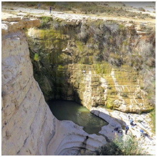
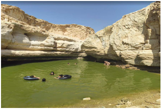
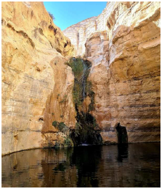
As it turns out, a few spring-fed pools, sunken and/or surrounded by high walls, exist in the Negev in the general vicinity of Sinai, Rephidim, and Elim. Bearing in mind that "ein" is the Hebrew word for "spring," there is, for example, Ein Akev (Figure 2). There is also Ein Yorkeam (Figure 3). But it is Ein Avdat (Figure 4) which gets us on the right track to discover Marah.
 |
 |
 |
Ein Avdat is one of a series of pools located along what today is called Wadi Zin. Wadi Zin is a seasonal river in the desert. For most of the year, the riverbed is dry, but during a rain, it may flood spectacularly and somewhat dangerously.
Wherever subsurface water rises to the surface in the wadi (i.e., wherever a spring occurs), a rare, year-round pool in the middle of the desert results.
The pool at Ein Avdat cannot be Marah. It is clearly being fed from above, as the waterfall in the photo shows. We are looking for a pool which is fed from its bottom, not via a waterfall from some spring farther upstream. Where does the water which is feeding the Ein Avdat waterfall emerge from the ground? That is the spring of interest in the present context.
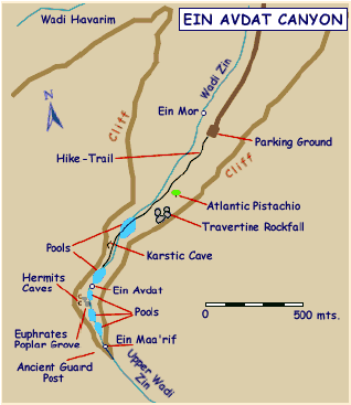
Fortunately, somebody once put together a helpful website on the Ein Avdat canyon. The original site was called www.caretakers4all.org. It no longer exists in its original form, but the content of interest to the present study can be accessed via web.archive.org. Of particular interest is the map from this website, shown in Figure 5. Most importantly, it shows three springs with "Ein Ma'arif" being the highest of the three. (Actually, it shows "Ein Maa'rif," but this seems to be a typo. It is spelled "Ma'arif" elsewhere on the caretakers4all.org website and also on Google Maps.) What immediately stands out is that there is a considerable phonetic similarity between "Marah" and "Ma'arif."
 |
The phonetic similarity of "Marah" to the name for the requisite uppermost, spring-fed pool, in the generally right location in the central Negev desert, seems to identify Ein Ma'arif with the biblical Marah more or less conclusively. But there is more.
The caretakers4all.org website supplies the only photograph of Ein Ma'arif which I have been able to find (Figure 6).
 |
This provides but a glimpse of the pool, but it is clear that it is bordered by a cliff, that trees grow there, and there is no sign of any year-round waterfall feeding this pool from a spring yet higher up. (There will, of course, be a temporary waterfall above this pool whenever Wadi Zin floods. The Figure 5 map shows that Ein Ma'arif lies within the Ein Avdat Canyon defined by the mapped cliffs.)
The caretakers4all.org website supplies the following facts:
Ein Avdat main stream runs from the upper level pool spring (Ein Ma'ariff) to the lower level pool (Ein Avdat) on unpermeable chalk.[3]Unlike the quantitative phase of heavy floods, caused by winter rain storms - the flow of Ein-Avdat is weak, but steady. Permanent water drops out from the permeable limestone layered above the impermeable chalk beds.[4]
Ein Avdat's soil and water are slightly saline and the canyon's plants have accommodated to salty conditions.[5]
These facts help clarify two things.
First, the Ma'arif spring evidently results from widespread horizontal contact between overlying permeable limestone and underlying softer but impermeable chalk. Rain will soak into the overlying limestone, which may be thought of something like a sponge in the present context. The water in the sponge percolates slowly down to the chalk floor. Because the chalk is impermeable, the water is trapped at the interface between the limestone and the chalk, unable to penetrate any deeper. But cracking the chalk will produce channels via which the water may penetrate into the chalk. Thus the flow into a pool in the limestone having a chalk bottom may be increased by cracking the chalk. This appears to have been the objective which Moses had in mind. He used a locally available tree to make a ram to shatter the chalk bottom of the pool to increase the flow of water into the pool from the surrounding limestone.
Second, the slight salinity of the water from Ein Ma'arif observed today shows that brackish water will easily result in the Ma'arif pool at lower flow rates.
The biblical record of the trek from Pi-hahiroth to Marah allows a simple check on the proposal that Ein Ma'arif is Marah.
The text says that the Israelites walked three days and found no water. This shows explicitly that Marah is more than three days from Pi-hahiroth, but less than four days. Using Google Maps, I find a straight line distance of 105 miles. At 30 miles per day (the maximal walking distance per day used previously in this series), this comes to 3.5 days. So this check is satisfied.
A further check is that the next encampment after Marah, Elim, is expected to be within a single day's journey from Marah. I measure just 5 miles as the crow flies, so this also works out right.
The discovery of the location of Marah provides a continuous path for the early part of the route of the Exodus (Figure 7): from Egypt to Succoth, on to Etham, back to Pi-hahiroth, and then on to Marah and Elim. ◇
 |
The Biblical Chronologist is written and edited by Gerald E. Aardsma, a Ph.D. scientist (nuclear physics) with special background in radioisotopic dating methods such as radiocarbon. The Biblical Chronologist has a fourfold purpose: to encourage, enrich, and strengthen the faith of conservative Christians through instruction in biblical chronology and its many implications, to foster informed, up-to-date, scholarly research in this vital field, to communicate current developments and discoveries stemming from biblical chronology in an easily understood manner, and to advance the growth of knowledge via a proper integration of ancient biblical and modern scientific data and principles. The Biblical Chronologist (ISSN 1081-762X) is published by: Aardsma Research & Publishing Copyright © 2023 by Aardsma Research & Publishing. Scripture quotations taken from the (NASB®) New American Standard Bible®, Copyright© 1960, 1971, 1977, 1995 by The Lockman Foundation. Used by permission. All rights reserved. www.Lockman.org |
^ Also spelled Nemtyemsaf.
^ Gerald E. Aardsma, Aging: Cause and Cure, 3rd ed. (Loda, IL: Aardsma Research and Publishing, in press). www.BiblicalChronologist.org.
^ web.archive.org/web/20110725141210/http://www.care takers4all.org/israel/einavdat/ezra9.htm
^ web.archive.org/web/20110725141913/http://www.care takers4all.org/israel/einavdat/avdat10.html
^ web.archive.org/web/20110725141938/http://www.care takers4all.org/israel/einavdat/avdat6.html