| |
| Volume 13, Number 6 | July 11, 2023 |
The Red/Reed Sea Crossing is one of the most well-known Bible stories. It is also one of the most misunderstood. Correct biblical chronology pinpoints the location of Pi-hahiroth, where the Israelites camped in front of the Red/Reed Sea at the time of the Crossing, and thereby pinpoints the body of water which was crossed.[1] Knowing the correct body of water allows the biblical narrative of the Crossing to be read in light of the physical features presented by that body of water today. When this is done, a new understanding and appreciation of what the biblical text is communicating about the Crossing emerges.
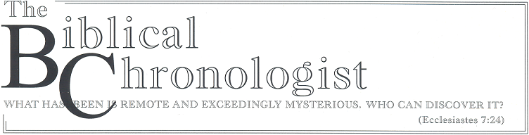
Common understanding of the Red/Reed Sea Crossing event seems to go something like this. After leaving Egypt, the Israelites were trapped by Pharaoh and his chariot army on the shores of the Red Sea. It looked as if the Israelites were about to suffer slaughter or re-enslavement. But overnight, God sent a wind which parted the waters of the Red Sea so that they stood up like a wall on either side of a dried up path through the sea to the other side (Figure 1), allowing the Israelites to escape. In the morning, when Pharaoh saw that the Israelites had escaped through the sea, he and his army went into the sea between the walls of water, chasing after them. But God stopped the wind, allowing the walls of water to return to normal, drowning Pharaoh and his army.
 |
The take-home lesson in this is generally regarded to be how God miraculously provided a way of escape for His people.
In reality, the whole Crossing event was not about escape for the Israelites. It was about judgment of Pharaoh and of Egypt.
"Thus I will harden Pharaoh's heart, and he will chase after them; and I will be honored through Pharaoh and all his army, and the Egyptians will know that I am the Lord." (Exodus 14:4)
The proper take-home lesson is that, though God is long-suffering, there comes a day of reckoning, and when it comes, it is not pretty.
What comes across loud and clear from the Exodus 14 narrative alone, whether one knows the correct site of the Crossing or not, is that God's purpose for having the Israelites cross the sea was not to make a way of escape for them. It was rather to make a way of doom for Pharaoh and his army.
The entire Crossing event was deliberately staged by God to enact His judgment on Pharaoh and Egypt. The Israelites had left Egypt, had crossed the Sinai Peninsula between Egypt and Canaan along the north Sinai road, and had camped on the threshold of the Promised Land at Etham. But instead of sending them forward into Canaan, God said to turn back and camp on the threshold of Egypt.
Now the Lord spoke to Moses, saying, "Tell the sons of Israel to turn back and camp before Pi-hahiroth, …" (Exodus 14:1–2a)While God is long-suffering, His day of judgment had come at long last for Pharaoh and for Egypt. What the text clearly reveals is that God deliberately set a death trap for Pharaoh and his army. God enticed Pharaoh out of Egypt by sending the Israelites back to his doorstep, and He enticed Pharaoh into the sea by sending the Israelites across it. In both instances, the Israelite people were merely the bait. And when He got Pharaoh and his army into the sea, He deliberately drowned the lot of them there.
The Israelites were not sent across the sea to escape. They were sent across the sea to bait a death trap. This is reinforced by the correct site of the Crossing.
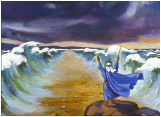
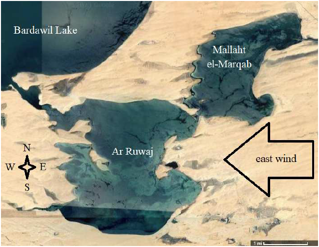
Figure 2 shows the body of water which was the site of the Red/Reed Sea Crossing. It is labeled "Ar Ruwaj" on Google Maps today.
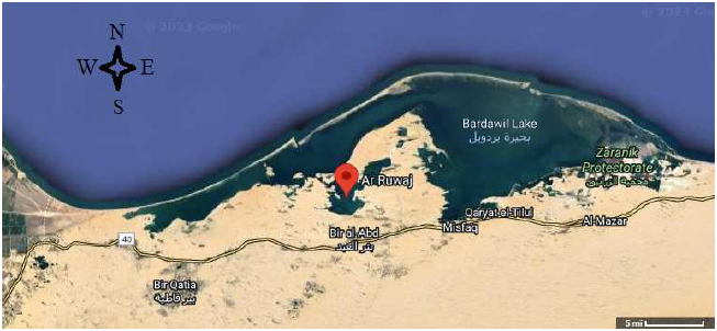 |
One need only look at a map of the Ar Ruwaj lagoon and its surroundings to see that the purpose of its crossing was not to make a path of escape for the Israelites. Figure 3 shows the situation of the Israelite Pi-hahiroth encampment (red oval) relative to Pharaoh's army (black dot) on the eve of the Crossing. As discussed above, the Israelites, at God's command, had come to this encampment (red arrow) traveling back along the North Sinai road toward Egypt from their encampment at Etham on the threshold of the Promised Land. After the Israelites had been at Pi-hahiroth a short while, probably a few days, Pharaoh with his army came out from Egypt along the North Sinai road (black arrow) with the objective of forcibly bringing the Israelites back to slavery in Egypt. Pharaoh's advance was halted by darkness. The map shows that there would have been some opportunity for the Israelites to escape under the cover of darkness at this point—if that had been the objective—through the desert into the mountainous terrain to the southeast (blue arrow) where Pharaoh's chariots would have been of little use. Instead, God opened a path for the Israelites northward (green arrow), through the Ar Ruwaj lagoon.
 |
Strategically, there was no escaping Pharaoh in this direction. Escape in this direction would have required a fleet of boats in Lake Bardawil to pick the Israelites up and carry them away. Pharaoh and his army were mobile, and they were in possession of the North Sinai road. Retreat of the Israelites to the north effectively trapped them against Bardawil Lake, cut off from escape by Pharaoh and his army to the south.
God was the Israelite General in this instance. Clearly, He was not making a path of escape for the Israelites. Rather, He was baiting a death trap for Pharaoh and his army. His objective was to annihilate the Egyptian army and to do so without a single Israelite casualty.
The biblical text is easily misunderstood in regard to the nature of the path through the sea.
It is easy to imagine this path as running through the middle of the sea with the water standing vertically like a wall on either side of the path (Figure 1). One need only look at the geometry of the Ar Ruwaj lagoon (Figure 4) to see that this cannot be what the text is saying. The text says that God used a "strong east wind" to make the path across the lagoon. No wind, from the east, could possibly dry a north–south path with vertical walls of water on either side of the path through the middle of Ar Ruwaj."And as for you, lift up your staff and stretch out your hand over the sea and divide it, and the sons of Israel shall go through the midst of the sea on dry land." (Exodus 14:16)
Then Moses stretched out his hand over the sea; and the Lord swept the sea back by a strong east wind all night, and turned the sea into dry land, so the waters were divided. And the sons of Israel went through the midst of the sea on the dry land, and the waters were like a wall to them on their right hand and on their left. (Exodus 14:21–22. Words in italics are not in the Hebrew text.)
 |
The Septuagint—the Greek translation of the Old Testament made several centuries before the time of Christ—changes the direction of the wind from the "east" of the Masoretic text (the source for our English translations) to "south." I suggest that this was likely a deliberate modification of the much more ancient Hebrew text to try to solve precisely this problem. I suggest that the Septuagint translators, who lived in the third century B.C., still retained knowledge of the correct location of the Crossing. They could see that no east wind could possibly blow a north–south path through the middle of Ar Ruwaj lagoon with standing walls of water on either side. So they moved the wind direction around to the south to try to solve the problem.
Changing the wind direction is not the right solution to the problem. The problem results from misunderstanding the text. A path through the middle of Ar Ruwaj lagoon is not the intended meaning, and a path with standing walls of water on either side is most certainly not the intended meaning. The scholars making the Septuagint translation, you will appreciate, lacked the satellite view of the lagoon and its surroundings which we are privileged to access with ease from our computers today. This satellite view reveals that the Ar Ruwaj lagoon has a unique geometry. This unique geometry yields an entirely different understanding of what it is that the Hebrew text is saying. It corrects our understanding of what is meant by the Hebrew text when it talks about dividing the water. It is not talking about dividing the sea in half with a narrow path through the middle. It is talking about dividing a remnant body of water in Ar Ruwaj lagoon from the extension of Ar Ruwaj lagoon called Mallaht el-Marqab, as shown in Figure 5. Allow me to explain.
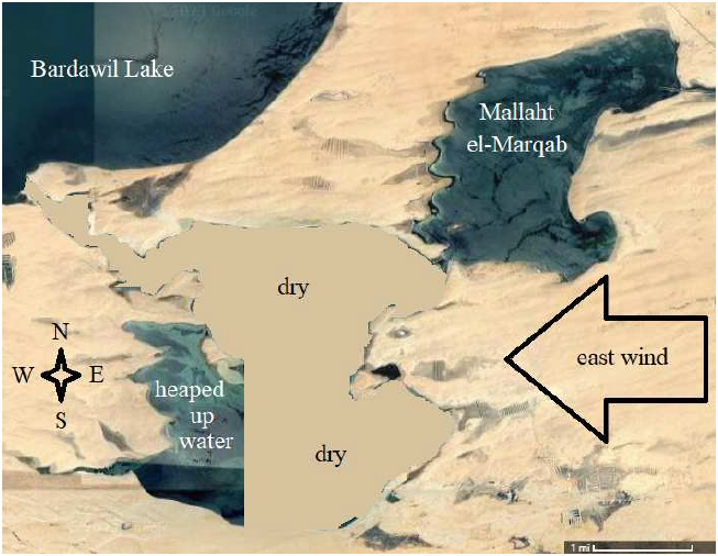 |
God's purpose was to drown Pharaoh and his army. To accomplish this purpose, it would be necessary to get Pharaoh and his army into the middle of the Ar Ruwaj lagoon where the water would be deep enough to drown them—Lake Bardawil is, in general, only six to ten feet deep. Pharaoh and his army would only get into the middle of the Ar Ruwaj lagoon if the water wasn't there. So, to set the death trap, it was necessary first to push the water out of the way.
Pushing the water out of the way was what the strong east wind was for. It was a wind coming in off of hundreds of miles of scorched desert to the east. It would have been not only strong but also warm and dry, so it had potential not only to push the water back out of the way but also to dry the resulting exposed bottom of the lagoon.
The trap was set by the waters of the lagoon being pushed to the west by the wind. To see how the water would behave in a strong east wind, imagine lifting the right side of Figure 4 a bit so the water flows down the resulting sloped landscape to the left. This is pretty much the same thing which the strong east wind would have done to the water of the lagoon.
You should be able to see that the strong east wind would naturally have done two things: 1) it would have flooded the western shoreline of the lagoon, and 2) it would have partially emptied the lagoon by water flowing out of the lagoon via the northwest channel into Bardawil Lake.
We are now in a position to understand properly what God meant when He commanded Moses:
"And as for you, lift up your staff and stretch out your hand over the sea and divide it, and the sons of Israel shall go through the midst of the sea on dry land." (Exodus 14:16)God is talking about converting Ar Ruwaj from how it looks in Figure 4 to how it looks in Figure 5.
The geometry of the shoreline of Ar Ruwaj is such that a strong east wind will naturally heap up water in the flooded southwestern arm of the Ar Ruwaj lagoon and keep it trapped there while the rest of the Ar Ruwaj lagoon is drained and dried by the wind. This divides the remnant water trapped in the southwestern arm of Ar Ruwaj lagoon from the water in the northeastern extension of Ar Ruwaj lagoon called Mallaht el-Marqab by a dried seafloor over a mile wide.
The trapped water in the southwestern arm is the death trap's lethal weapon. It is a treacherous catastrophe waiting to happen. Bear in mind that this body of trapped water is no longer comprised of just the water that normally sits in this arm of the lagoon. The western shoreline is flooded because of the strong east wind. Water has been heaped up by the wind in this southwestern arm. The eastern edge of the trapped water is windswept, similar to the left wall of water in Figure 1, though not nearly so steep. And bear in mind that all of the water in this southwestern arm, being held there by the wind, is at a higher elevation than the bottom of the lagoon. Should the wind suddenly stop, this heaped up water will come rushing back into the bottom of the lagoon like a tsunami.
Thus, the Ar Ruwaj lagoon has been converted by the strong east wind into a death trap.
The wind would make it possible for Pharaoh and his army to get out into the middle of the lagoon on dry land, but he would still have no reason to go there. There needed to be a bait for this trap to work.
The Israelites were the bait. They had been used as bait to entice Pharaoh out of Egypt. Now they would be used as bait to entice him into the lagoon death trap.
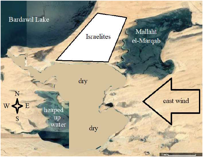
To function as bait, the Israelites needed to be positioned on the dry land to the north of the lagoon so that Pharaoh, positioned to the south of the lagoon, would need to cross the lagoon to get at them.
The Israelites crossed the lagoon on dry ground in the early morning hours, while it was yet dark. Figure 6 shows the properly positioned "bait."
 |
We are now in a position to understand what the text is talking about with the water being like walls. It is not talking about vertical walls of water to let the Israelites pass through the lagoon from south to north. Other than the water trapped in the southwestern arm, the lagoon is dry at this point in the story. The text explicitly says, "and turned the sea into dry land" (Exodus 14:21). There was no need to tunnel a path through any waters. The Israelites simply walked across the dry seabed from the south shore to the north shore.
Now here is what the text is telling us. It is telling us that when the Israelites were situated on the dry land to the north of Ar Ruwaj lagoon, their flanks were protected from attack by the waters of Lake Bardawil on the west side and by the waters of Mallaht el-Marqab on the east side.
Recall that the ancient Hebrew text had no punctuation. I suggest that the punctuation supplied by the NASB translators for this part of the narrative—Exodus 14:22—is incorrect. The two phrases which make up this verse should be sequential, not simultaneous. As translated, it is punctuated:
And the sons of Israel went through the midst of the sea on the dry land, and the waters were like a wall to them on their right hand and on their left.It should be punctuated:
And the sons of Israel went through the midst of the sea on the dry land. And the waters were like a wall to them on their right hand and on their left.The text means to communicate that, once the Israelites had gotten across the sea, then they were between two bodies of water which were like defensive walls, protecting them from a side attack by Pharaoh and his army.
This narrative is, after all, much concerned with a military operation by Pharaoh and his army, and the fact that the Israelites were protected from flank attacks by bodies of water on either side has large military significance. It means that Pharaoh had only one tactical option: a frontal attack.
Now, if you put yourself in Pharaoh's sandals, you will see that it looks for all the world to Pharaoh as if Moses has positioned the people, including the Israelite fighting men, in the best possible defensive position for a battle. It looks as if Moses means to fight, and he has arranged for Pharaoh's 600-plus chariots to have to come at them head on, up the hill from the bottom of the lagoon. It appears to Pharaoh to be the ultimate military dare—an uphill, frontal attack.
It is pretty predictable that Pharaoh will scoff at this dare. He has shown himself repeatedly to be good at scoffing at Moses and Moses' God. And he knows that the Israelite fighting men are not trained soldiers. They have only recently left Egypt, and they are little more than a big mob of slaves. Furthermore, he knows that the slope up out of the lagoon is not likely to be too steep—the lagoon is only ten feet deep. He is happy to accept this dare. He feels confident that he will win. He is unaware that the whole thing is a ruse. He is unaware that the true military objective is simply to get him into the death trap.
Thus, the death trap has been ingeniously baited.
Picture Pharaoh and his army, about a half hour later, in the middle of the north half of the Ar Ruwaj lagoon. At this point, God causes the chariots to start misbehaving, and this causes Pharaoh's army to panic. They begin a hasty retreat. But the wind suddenly stops. The enormous mass of water stored in the southwestern arm of the lagoon comes rushing back into the bottom of the lagoon. This water will come gushing through the narrow neck separating the northern half of Ar Ruwaj from its southern half. The retreat of Pharaoh's army southward will bring it into a head-on collision with this rushing flood. The result will be a deadly, 600-plus chariot pileup in the bottom of the lagoon.
Then the Egyptians took up the pursuit, and all Pharaoh's horses, his chariots and his horsemen went in after them into the midst of the sea. And it came about at the morning watch, that the Lord looked down on the army of the Egyptians through the pillar of fire and cloud and brought the army of the Egyptians into confusion. And He caused their chariot wheels to swerve, and He made them drive with difficulty; so the Egyptians said, "Let us flee from Israel, for the Lord is fighting for them against the Egyptians."
Then the Lord said to Moses, "Stretch out your hand over the sea so that the waters may come back over the Egyptians, over their chariots and their horsemen." So Moses stretched out his hand over the sea, and the sea returned to its normal state at daybreak, while the Egyptians were fleeing right into it… (Exodus 14:23–27)
This phrase, "fleeing right into it," has always seemed irreconcilable with the notion of walls of water on either side of a narrow path. It doesn't matter whether an army is advancing or retreating along such a path when the walls collapse. In what sense does retreating uniquely cause the soldiers to be "fleeing right into it" when the walls collapse?
But when we get the chronology of the Exodus right, and hence get led to the proper site by Exodus pottery, and thereby learn about the unique geometry of Ar Ruwaj lagoon, the old problem with "fleeing right into it" simply disappears. ◇
The Biblical Chronologist is written and edited by Gerald E. Aardsma, a Ph.D. scientist (nuclear physics) with special background in radioisotopic dating methods such as radiocarbon. The Biblical Chronologist has a fourfold purpose: to encourage, enrich, and strengthen the faith of conservative Christians through instruction in biblical chronology and its many implications, to foster informed, up-to-date, scholarly research in this vital field, to communicate current developments and discoveries stemming from biblical chronology in an easily understood manner, and to advance the growth of knowledge via a proper integration of ancient biblical and modern scientific data and principles. The Biblical Chronologist (ISSN 1081-762X) is published by: Aardsma Research & Publishing Copyright © 2023 by Aardsma Research & Publishing. Scripture quotations taken from the (NASB®) New American Standard Bible®, Copyright© 1960, 1971, 1977, 1995 by The Lockman Foundation. Used by permission. All rights reserved. www.Lockman.org |
^ Gerald E. Aardsma, "The Route of the Exodus," The Biblical Chronologist 2.1 (January/February 1996): 1–9. Gerald E. Aardsma, The Exodus Happened 2450 B.C. (Loda, IL: Aardsma Research and Publishing, 2008), 61–69. www.BiblicalChronologist.org.
^ From freebibleimages.org/illustrations/moody-moses-red-sea/?ct=t%28March_15_v1%29.