
| |
| Volume 13, Number 7 | September 8, 2023 |
Mount Hor is Encampment 33 according to the list of encampments from Egypt to the Jordon River found in Numbers 33. The present article reveals the true location of Mount Hor. As with previous discoveries of encampment sites disclosed in this research newsletter, such as Mount Sinai,[1] Rephidim,[2] and Marah,[3] the discovery of the true location of Mount Hor brings to life the biblical record of the Israelites' stay there, dispelling age-old misconceptions in the process.
How the Israelites came to encamp at Mount Hor is a tale in itself.
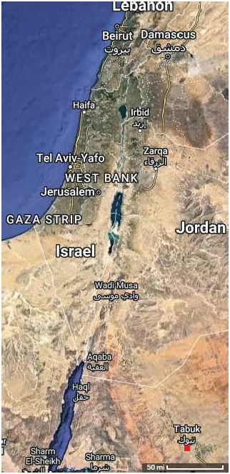
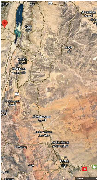
Prior to Mount Hor, the Israelites had stayed at Kadesh-barnea for nearly four decades. They had come to Kadesh-barnea, way down in the southeast corner of the (eventual) historic nation of Israel (Figure 1), expecting to begin the Conquest from there. The Conquest (which should really be called the Eviction) was intended to free their ancestral homeland, given to them by God as their inheritance, from squatters—the various people groups which had accumulated in it during the multiple centuries in which they themselves had been forcibly enslaved in Egypt. But, through fear and unbelief, they had botched the launching of the Eviction/Conquest, and as a result, they had spent nearly forty years in Kadesh-barnea, under God's judgment, waiting for the generation which had failed to follow God's plan to die off.
 |
Now, at long last, the baton had passed to the new generation. But when the older generation had failed to follow God's plan, had rebelled against Moses' leadership, and had taken matters into their own hands, they had blown the militarily important element of surprise in a too-late, half-baked, presumptuous first attack, which had ended in defeat and rout. This had made the Israelites' military intentions completely clear to the squatters. It had also shown the squatters that the Israelites were not invincible, emboldening them. All of the people groups in the southern portion of the country—all of the neighboring squatters—had now had decades to fortify themselves against the return of the Israelites.
To avoid heavy Israelite casualties, the renewed Eviction/Conquest would need a clever new strategy. This new strategy called for the Eviction/Conquest to be launched as a surprise in an unexpected quarter far to the north. The objective was to penetrate the Promised Land in the middle of its east flank, thereby dividing it into two military zones, southern and northern. They would assemble the army to the east of the Jordan River opposite Jericho to begin the penetration by crossing the Jordan River and attacking Jericho (Figure 2).
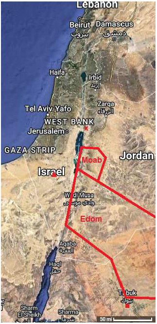 |
The kingdoms of Edom and Moab lay between Kadesh-barnea and the Jordan River crossing at Jericho. The peoples of both Edom and Moab were ancient relatives of the Israelites. The nation of Israel was descended through the line of Abraham, Isaac, and Jacob. Edom was descended from Jacob's twin brother Esau. Moab was descended through Abraham's nephew Lot. Neither Edom nor Moab was a military target of the Eviction/Conquest. God explicitly forbade the Israelites to harm them in any way (Deuteronomy 2:1–9). He had given their land to them, and the Israelites were not to attempt to take it from them.
From Kadesh-barnea, Moses petitioned the king of Edom for permission to pass northward through his kingdom on the highway.
But the king of Edom refused.From Kadesh Moses then sent messengers to the king of Edom: "Thus your brother Israel has said, 'You know all the hardship that has befallen us; that our fathers went down to Egypt, and we stayed in Egypt a long time, and the Egyptians treated us and our fathers badly. But when we cried out to the Lord, He heard our voice and sent an angel and brought us out from Egypt; now behold, we are at Kadesh, a town on the edge of your territory. Please let us pass through your land. We shall not pass through field or through vineyard; we shall not even drink water from a well. We shall go along the king's highway, not turning to the right or left, until we pass through your territory.' " (Numbers 20:14–17)
The alternative—a long and arduous journey through the desert around the backside of Edom and Moab—was to be avoided if at all possible. The strategy called for a surprise attack far to the north, before the squatters knew the Israelites were coming, to catch them unprepared. Safeguarding the element of surprise depended on rapid relocation from Kadesh-barnea to the target. The entire nation would need to be moved. Supply lines for the army could not be maintained over such a long distance. Moving the entire nation—infants, toddlers, pregnant women, the very elderly—a dozen or more days' journey rapidly through the desert would be a gruelling hardship for the nation.
If instead they could travel through the relatively populous heartlands of Edom and Moab along the king's highway, the distance would be significantly shorter, less hazardous, and they would easily be able to purchase fresh food and water as they went. In contrast, if they went the long way around via the backside of the relatively unpopulated desert, they would be venturing through a frontier something akin to America's Wild West in pioneer days. Unknown hazards would abound, and there would be essentially no prospect of purchasing fresh supplies along the way.
Accordingly, Moses applied to the king of Edom for permission to use the kings' highway a second time. But again he was refused, and this time the king of Edom brought out his army in a show of force blocking the way. They would need to take the long, hard road through the desert, and they would need to move along it at a very rapid pace.
In fact, the Numbers 33 itinerary of encampments shows a strong contrast between their rate of travel to the southeast when they had come to Kadesh and their rate of travel back to the north after they had left Kadesh. It lists twenty intervening encampments from Mount Sinai southeast to Kadesh, and only four intervening encampments from Kadesh to their arrival back in the north, east of Moab.
The Judge, Jephthah, some 300 years later, recounted this bit of history in the course of a conflict he was engaged in with the king of Ammon. (Ammon was half-brother of Moab.)
Now Jephthah sent messengers to the king of the sons of Ammon, saying, "What is between you and me, that you have come to me to fight against my land?" And the king of the sons of Ammon said to the messengers of Jephthah, "Because Israel took away my land when they came up from Egypt, from the Arnon as far as the Jabbok and the Jordan; therefore, return them peaceably now." But Jephthah sent messengers again to the king of the sons of Ammon, and they said to him, "Thus says Jephthah, 'Israel did not take away the land of Moab, nor the land of the sons of Ammon. For when they came up from Egypt, and Israel went through the wilderness to the Red Sea and came to Kadesh, then Israel sent messengers to the king of Edom, saying, "Please let us pass through your land," but the king of Edom would not listen. And they also sent to the king of Moab, but he would not consent. So Israel remained at Kadesh. Then they went through the wilderness and around the land of Edom and the land of Moab, and came to the east side of the land of Moab, and they camped beyond the Arnon; but they did not enter the territory of Moab, for the Arnon was the border of Moab. …' " (Judges 11:12–18)
It seems likely that the roads back in Moses' time were in much the same places as they are today. The region is desert, and travel in the desert, up until relatively recent times, with the advent of high-speed, motorized travel, would have been dictated by the availability of water. The roads would have run from one source of water—e.g., a well—to the next. Since the sources of water were fixed in place, the roads, too, would have tended to remain fixed in place from generation to generation.
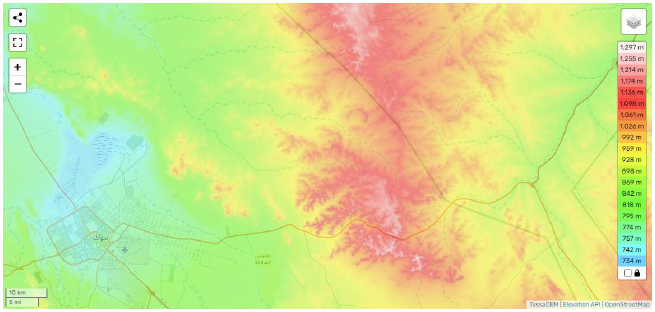
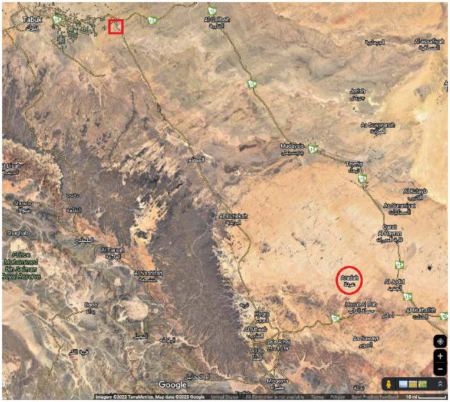
There are three roads out of modern Tabuk (Figure 3): one to the west, another to the north, and a third to the east. Moses had wanted to leave Kadesh by the road to the north, but this direction was blocked by the king of Edom. To go the alternative route, around the backside of Edom, he would have needed to have left Kadesh by the road to the east. Thus it appears that the final leg of the route of the Exodus would have initiated from Tabuk eastward along modern Route 15.
 |
The first stop out of Kadesh-barnea was Mount Hor.
Now when they set out from Kadesh, the sons of Israel, the whole congregation, came to Mount Hor. (Numbers 20:22)As at Mount Sinai, the Israelites would have camped on the plain before the mountain, not on the mountain itself.
The biblical record implies that Mount Hor would have been located not terribly far from Kadesh-barnea. They stayed at Mount Hor for an entire month (see below). As long as they were close to Kadesh, the fact that they were venturing out on a fundamentally military expedition far to the north would remain hidden from enemy eyes.
Is there any mountain out eastward from Kadesh-barnea, along Route 15?
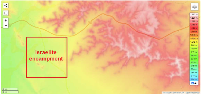
Yes. As it turns out, there is one, and only one, mountain. Its presence is revealed by the topographical map[4] shown in Figure 4. The base of the mountain, where the encampment would have been, is just a day's journey (i.e., 30 miles) from Tabuk/Kadesh.
 |
Because this mountain is suitably-positioned, and because it is the only suitably-positioned mountain, it may immediately be assigned as the biblical Mount Hor. I have, so far, been unable to discover its modern name, so I will refer to it simply by its biblical name, "Mount Hor," throughout the remainder of this article.
Mount Hor is a fairly low-lying, sprawling mountain, not a towering pinnacle, though it is significantly higher and more prominent than Mount Sinai (Mount Yeroham). Mount Sinai's present elevation is roughly 650 meters (2,100 feet), and it rises above the Sinai plain by just 180 meters (590 feet). Mount Hor's elevation is roughly 1,290 meters (4,230 feet), and it rises above its plain by 450 meters (1,500 feet). These measurements show that Mount Hor is two-and-a-half-times more prominent than Mount Sinai.
A low, sprawling mountain is more suitable to the narrative than a steep, towering mountain would be, for the now very elderly Aaron, 123 years old, would need to climb this mountain to die.
Then the Lord spoke to Moses and Aaron at Mount Hor by the border of the land of Edom, saying, "Aaron shall be gathered to his people; for he shall not enter the land which I have given to the sons of Israel, because you rebelled against My command at the waters of Meribah. Take Aaron and his son Eleazar, and bring them up to Mount Hor; and strip Aaron of his garments and put them on his son Eleazar. So Aaron will be gathered to his people and will die there." So Moses did just as the Lord had commanded, and they went up to Mount Hor in the sight of all the congregation. And after Moses stripped Aaron of his garments and put them on his son Eleazar, Aaron died there on the mountain top. Then Moses and Eleazar came down from the mountain. When all the congregation saw that Aaron had died, the whole house of Israel wept for Aaron for thirty days. (Numbers 20:23–29)
At the end of the period of mourning, there followed an attack upon the Israelites by the king of Arad.
When the Canaanite, the king of Arad, who lived in the Negev, heard that Israel was coming by the way of Atharim; then he fought against Israel, and took some of them captive. So Israel made a vow to the Lord, and said, "If Thou wilt indeed deliver this people into my hand, then I will utterly destroy [literally: devote to destruction] their cities." And the Lord heard the voice of Israel, and delivered up the Canaanites; then they utterly destroyed them and their cities. Thus the name of the place was called Hormah [i.e., a devoted thing; or, Destruction]. (Numbers 21:1–3)
Several long-standing mysteries arise with this brief account of the conflict with the king of Arad at Mount Hor. For example, what exactly is the significance of "the way of the Atharim" to which it refers? Indeed, what even is the meaning of the Hebrew word transliterated here as "Atharim"? And why had the king of Arad not come and fought against Israel all the while they had lived on the open plain at Kadesh, just a day down the road from Mount Hor? And why does Israel seem to be relatively passive in the initial battle? The text says only that, "he [the king of Arad] fought against Israel." There is no real indication that Israel fought back when the king of Arad made his attack. Israel had a huge, trained army at this point—over half a million men. Why is there no description of a huge battle? And why is there mention that the king of Arad managed to take some of the Israelites captive, but no reciprocal mention of injuries inflicted on the armies of Arad by the Israelites in the initial conflict?
The present discovery, of the true mountain corresponding to the Mount Hor of Numbers chapter 20, solves these mysteries.
The all-important fact, clearly seen in Figure 5, not stated by the biblical narrative, is that the road from Kadesh around the backside of Edom does not merely run close to Mount Hor, it rather runs through Mount Hor. Now notice, in Figure 5, that the road changes from orange to red and then back to orange as it crosses the mountain. This shows that the road first ascends the mountain and then descends on the far side. Also notice that the mountain on either side of the red portion of the road is colored pink and white. This means that the modern road is in a narrow pass as it crests the mountain.
 |
When viewed enlarged via Google Maps, this section of the road shows evidence of relatively recent straightening. But the road overall runs in natural wadi beds either side of the mountain, and these beds narrow as they approach the water divide at the crest of the mountain, ensuring that the ancient road would have similarly narrowed as it crested the mountain. Thus, the nation of Israel, on resumption of its journey, would have needed to funnel through a mountain pass having a narrow restriction near the crest of the ancient road.
With this real-life setting before our eyes, the biblical narrative of the conflict with the king of Arad at Mount Hor springs to life. One sees immediately that the king of Arad is not fighting against Israel in open warfare at Mount Hor. He is rather staging an ambush at some point along the pass—probably at its narrowest point, near the crest. There is no real battle—no real engagement of armies. In fact, the king of Arad probably has with him a relatively small army, for it is not his purpose to defeat Israel in open battle. Rather, like a band of Wild West highway robbers, his purpose is to grab what wealth he can—mainly in the form of captured Israelites, valuable as slaves—and make off with it beyond the horizon before Israel can organize any effective response. His whole action centers around the knowledge of the pass through the mountain. He will wait in ambush until whatever number of Israelites he feels his army can quickly overwhelm emerges from the narrowest part of the pass, and then he and his men will jump out, cutting off further egress of any more Israelites through the narrow pass. These Israelites, stuck in the pass, surprised and unable to tell how large a force has assailed them, will naturally retreat back along the pass to group up and decide on a plan of action. Meanwhile, the king of Arad will make off for home at rapid pace with the Israelites he has captured.
The captured Israelites would likely have been soldiers, of the tribe of Judah, not families. Numbers 10:11–28 specifies the order in which the tribes were organized as the Israelite tent-city was moved from one encampment to the next subsequent to the Israelites' stay at Mount Sinai. The tribal armies appear to have led the way.
And the standard of the camp of the sons of Judah, according to their armies, set out first,… This was the order of march of the sons of Israel by their armies as they set out. (Numbers 10:14a, 28)
The meaning of "Atharim"—a word of single usage in the Bible, whose translation has previously been obscure—now seems clear. "Atharim" seems to mean a mountain "pass," like this:
According to Strong's,[5] the root "Athar" is thought to mean "step," as to take a step. "Atharim" is plural: "steps." This yields the concept of a path. In the present context, the path is through a mountain. We call a path through a mountain a "pass."[6]When the Canaanite, the king of Arad, who lived in the Negev, heard that Israel was coming by the way of the pass; then he fought against Israel, and took some of them captive.
I suggest that the reason the narrative doesn't mention explicitly the important fact that the road ran through Mount Hor is that this fact was originally implicit in the use of the word "pass," making explicit mention unnecessary. Unfortunately, the eventual loss of the meaning of the word "atharim" caused this all-important fact also to be lost.
With this much understood, the identification of the proper location of the kingdom of Arad should now, at long last, be possible.
For many years, Arad was identified with Tel 'Arad, west of the Dead Sea (Figure 6).
 |
In more recent times, this identification of Arad has been rejected by mainstream scholars.
This has left the site of the biblical kingdom of Arad unidentified with respect to mainstream (i.e., mistaken-biblical-chronology) scholarship—helping to fuel mistaken theories which regard the biblical narrative of the Exodus as essentially nonhistorical among mainstream scholars today.The findings unearthed by the excavations again raise the question of whether this site is to be identified with ancient Arad. Because no remains of the city were found from the Middle to the Late Bronze Ages [mistakenly believed to be Canaanite by mainstream scholars], it is impossible to identify the site with Canaanite Arad.[7]
When working with the correct, missing millennium chronology,[8] Tel 'Arad similarly fails to yield a viable candidacy for the Arad of Numbers 21. It now fails both with respect to chronology and with respect to geography.
Regarding chronology, according to the excavators, the city at Tel 'Arad was destroyed by enemy attack only once, roughly 2800 B.C. The biblical narrative of the conflict between Arad and Israel at the time of the Exodus took place roughly 2450 B.C., 350 years later. Evidently, Tel 'Arad was already no more than an ancient ruin by the time the Exodus happened.
Regarding geography, Tel 'Arad is located very far to the north of the encampment at Kadesh-barnea/Tabuk identified in this series, and it is even farther away from the encampment at Mount Hor identified in the present article. The idea that any king from the inhabited region of the Negev desert would take his army on a roughly 12-day journey southeast to Mount Hor to launch an ambush on Israel—and from the far (east) side of the mountain, of all things—via the pass through the mountain, for the sake of capturing a few slaves, is clearly not tenable. The kingdom of Arad must have been located relatively close to Mount Hor, not far to the northwest in the eastern Negev desert.
The primary clue to the correct whereabouts of the biblical kingdom of Arad is the location specified by Numbers 21:1.
In the Bible, "the Negev" often refers to the desert located in the south of modern-day Israel. But "Negev" simply means "south" in Hebrew, and "south" appears to be the correct translation in this instance.When the Canaanite, the king of Arad, who lived in the Negev, …
When translated this way, the kingdom of Arad should be looked for to the south of Mount Hor.When the Canaanite, the king of Arad, who lived in the south, …
The main thing one might expect to find today, showing the location of the kingdom of Arad, is a region having a collection of modern settlements. This would reveal a region having a sufficient water supply to support a kingdom made up of individual cities in the distant past.
Using Google Maps once again (Figure 7), a suitable clustering of settlements is seen only in a southeasterly direction from Mount Hor. There is no clustering of settlements within a reasonable distance to the north of Mount Hor, for example, and neither is one found to the east of Mount Hor.
 |
The fact that one of the modern-day settlements in the south-south-easterly cluster, at Google Maps coordinates (27.039482, 38.482009), bears the name "Aradah" seems to confirm that this general region is indeed the one which should be identified with the biblical kingdom of Arad. Aradah lies roughly 120 miles—a 4-days' journey for the Israelites—south of Mount Hor. The Israelites marched on the kingdom of Arad, completely destroying it, as a military reprisal for the unprovoked attack on them by the king of Arad and, no doubt, to rescue their captured comrades.
Having located the kingdom of Arad, yet more of the biblical Exodus narrative springs to life.
In the retelling to the new generation of Israelites of the botched Eviction/Conquest attempt, Moses says, "And the Amorites who lived in that hill country came out against you, and chased you as bees do, and crushed you from Seir to Hormah" (Deuteronomy 1:44).
Seir is the homeland of Edom (Figure 8). Mount Seir forms Edom's western border. Edom, we now know, lay broadside all along to the north of Kadesh-barnea, extending from the Arabah Valley in the west, south-eastward at least as far as Mount Hor. The Edomites, not the Amorites, lived there.
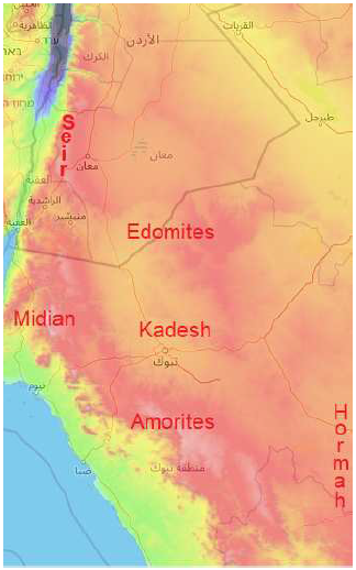 |
Hormah is the name given to the kingdom of Arad following its destruction. It lay, we now know, to the south-east of Kadesh-barnea. The kingdom of Arad was populated by Canaanites, not Amorites. This leaves only the west and the south for the homeland of the mentioned Amorites.
The region to the west of Kadesh-barnea is traditionally regarded as the possession of the Midianites. This assignment provides an explanation of why the Israelites were able to stay, unchallenged, at Kadesh-barnea. It seems possible that Kadesh-barnea was somewhat of a backwater within Midianite territory, and Moses' marriage to a Midianite woman afforded the Israelites sufficient "diplomatic immunity" for them to live there in safety, unchallenged by Midianite authorities.
If this assignment is correct, then only the south remains as the homeland of the mentioned Amorites. Evidently, it was into the mountains to the south of Kadesh-barnea that the attack by the previous generation's Israelite rebel warriors was launched. The account says that they "went up to the ridge of the hill country" (Numbers 14:40). When viewed from the plain, a ridge is the line of hills or mountains on the horizon. Thus in this expression, "from Seir to Hormah," Moses is saying that the counterattack by the Amorites drove the rebel Israelite warriors back out of the hills and resulted in a complete rout which scattered the Israelite rebels from one extreme end to the other of the plain in which Kadesh-barnea sits.
The enemy would have needed to stop chasing the Israelite rebels once they got to the kingdom of Arad for fear of provoking war with Arad. But it seems likely that some of the Israelite rebels, chased into the kingdom of Arad, would have fallen captive to the king of Arad at that time. These would have had value either for ransom, or as slaves for service within the kingdom of Arad, or as slaves for sale to neighboring nations.
This experience within the kingdom of Arad a generation earlier, back at the coming of the Israelites to Kadesh-barnea, may have been the inspiration for the king of Arad's plan to snag a bevy of Israelite slaves via an ambush at the pass through Mount Hor at the departure of the Israelites from Kadesh-barnea. Thus are the sins of the fathers paid for by the sons. And yet, thus also does God turn evil to good, hardening the new generation of Israelite warriors for the task which lay immediately ahead of them of clearing the Promised Land of squatters, while at the same time removing a, no doubt, perennial scourge for unsuspecting travelers from the Mount Hor pass. ◇
The Biblical Chronologist is written and edited by Gerald E. Aardsma, a Ph.D. scientist (nuclear physics) with special background in radioisotopic dating methods such as radiocarbon. The Biblical Chronologist has a fourfold purpose: to encourage, enrich, and strengthen the faith of conservative Christians through instruction in biblical chronology and its many implications, to foster informed, up-to-date, scholarly research in this vital field, to communicate current developments and discoveries stemming from biblical chronology in an easily understood manner, and to advance the growth of knowledge via a proper integration of ancient biblical and modern scientific data and principles. The Biblical Chronologist (ISSN 1081-762X) is published by: Aardsma Research & Publishing Copyright © 2023 by Aardsma Research & Publishing. Scripture quotations taken from the (NASB®) New American Standard Bible®, Copyright© 1960, 1971, 1977, 1995 by The Lockman Foundation. Used by permission. All rights reserved. www.Lockman.org |
^ Gerald E. Aardsma, "Yeroham—The True Mt. Sinai?" The Biblical Chronologist 1.6 (November/December 1995): 1–8. www.BiblicalChronologist.org.
^ Gerald E. Aardsma, "The Route of the Exodus, Part IV: The Identification of Rephidim," The Biblical Chronologist 13.3 (March 14, 2023): 1–13. www.BiblicalChronologist.org.
^ Gerald E. Aardsma, "The Route of the Exodus, Part VI: The Location of Marah," The Biblical Chronologist 13.5 (June 13, 2023): 1–6. www.BiblicalChronologist.org.
^ All topographical maps this issue are sourced using en-gb.topographic-map.com.
^ Strong's Exhaustive Concordance of the Bible, (Peabody, Massachusetts: Hendrickson Publishers), entry 871 of the "Hebrew and Chaldee Dictionary".
^ In reviewing the original manuscript for the present article, Tom Godfrey (personal communication, August 29, 2023) commented:
By the way, this reminds me of a city whose name is Spanish and means The Pass or The Step (https://en.wikipedia.org/wiki/El_Paso,_Texas). The noun paso actually has many possible translations. My best reference (https://www.amazon .com/Simon-Schusters-International-Dictionary-English/dp/0671212672) lists 22 for paso, but the first one listed is "step, pace (movement of feet)." Number 8 is "pass (e.g. between mountains); (geog.) strait (narrow passage of water)."
^ Miriam Aharoni, "Arad," The New Encyclopaedia of Archaeological Excavations in the Holy Land, vol. 1 (New York: Simon & Schuster, 1993), 85.
^ Gerald E. Aardsma, A New Approach to the Chronology of Biblical History from Abraham to Samuel, 2nd ed. (Loda, IL: Aardsma Research and Publishing, 1995). www.BiblicalChronologist.org.