
| |
| Volume 14, Number 1 | January 23, 2024 |
Though Ezion-geber's general location has been known for a very long time, its specific location has remained a mystery. The present article aspires to show the solution to this mystery.
According to the Numbers 33 itinerary of Israelite encampments following the Exodus of the Israelites from Egypt, Ezion-geber is encampment 31. It is followed by Kadesh-barnea, encampment 32.[1] Kadesh-barnea is followed by Mount Hor, encampment 33.[2]
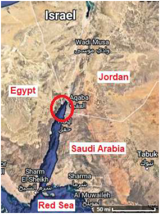
It is difficult to get the general location of Ezion-geber wrong. The giveaway results from the fact that Ezion-geber is mentioned in the biblical historical narrative of the nation of Israel not only in connection with the Exodus but also much later on in history in connection with the reign of Solomon, and there it is mentioned in such a way as to make its general location—somewhere along the shoreline of the Gulf of Aqaba—indisputable.
King Solomon also built a fleet of ships in Ezion-geber, which is near Eloth [Elath][3] on the shore of the Red Sea, in the land of Edom. (1 Kings 9:26)[4]
This verse specifies that Ezion-geber was a sea-going port at the time of Solomon. The general location of this port on the shoreline of the Gulf of Aqaba seems to be affirmed by the further specification, "on the shore of the Red Sea," the Gulf of Aqaba being a part of the Red Sea. Unfortunately, complete certainty on this basis alone is denied in this instance as a result of underlying uncertainties associated with the meaning of the Hebrew "yam suph," which is here translated as Red Sea. But it is known that Edom was located southeast of Israel, in modern Jordan,[5] and thus that the port of Ezion-geber was not located anywhere along the Mediterranean coastline bordering Israel to the west. This leaves only the coastline of the Gulf of Aqaba as a possibility for the port of Ezion-geber.
This general location may be narrowed somewhat by the fact that Israel, at the time of Solomon, was located to the north of the Gulf of Aqaba. This leads to an expectation that Ezion-geber would likely have been situated somewhere on the shoreline of the upper reaches of the Gulf of Aqaba (Figure 1) rather than farther down.
 |
These simple deductions reveal the general location of Ezion-geber. In keeping with the present "Route of the Exodus" series, my purpose in the present article is to go beyond this, showing the specific site where the Israelites actually camped.
The generally accepted specific location of Ezion-geber—"somewhere in the area of modern Aqaba and Eilat,"[6] i.e., at the northern extremity of the Gulf of Aqaba—appears to be wrong. It would not have made good sense for the Israelites to stop at the tip of the Gulf of Aqaba immediately prior to proceeding on the final leg of the journey to Kadesh-barnea. It appears that Ezion-geber should be sought, not near the tip of the Gulf of Aqaba, but farther down the northeast coast. This may be seen as follows.
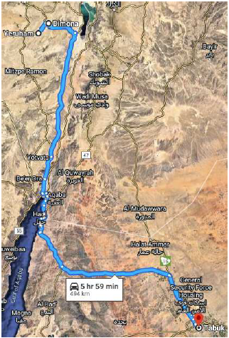
The Israelites of the Exodus were traveling from Mount Sinai, now known to correspond to modern Mount Yeroham,[7] to Kadesh-barnea, now known to correspond to modern Tabuk.[8] According to the Numbers 33 itinerary, Ezion-geber was their twentieth encampment since leaving Mount Sinai. Kadesh-barnea would be their next stop.
I have previously charted a possible route from Yeroham/Sinai to Tabuk/Kadesh-barnea along modern roads (Figure 2).[9] The natural expectation is that the Israelites would simply have camped beside the road. Assuming, as seems most likely, that these modern roads correspond to ancient routes of travel back at the time of the Exodus, it is immediately evident that the Ezion-geber encampment should not be sought anywhere along the northwest coastline of the Gulf of Aqaba. Only the north and northeast coastlines are of interest.
 |
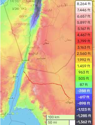
The Numbers 33 itinerary informs us, as mentioned above, that from Ezion-geber the Israelites made the final leg of their journey to Kadesh-barnea in a single stint with no intervening encampments. This appears very odd at first sight. Having reached the Gulf of Aqaba, the Israelites had covered roughly half the distance from Mount Sinai to Kadesh-barnea.[10] So, oddly, while they had camped 19 times on the first half of their journey, from Mount Sinai to Ezion-geber, they would make no intervening encampments on the second half of their journey, from Ezion-geber to Kadesh-barnea.
The biblical historical narrative does not explain the reason for this, but the natural topography between the Gulf of Aqaba and Tabuk/Kadesh-barnea (Figure 3) provides a ready explanation. From Ezion-geber, the Israelites would need to cross a range of mountains to reach the interior plain on which Kadesh-barnea was located. Crossing the mountains would naturally have been arduous. They were not merely taking themselves over the mountains. They were taking themselves and all their household belongings and home industry equipment and the "house" itself (the tent) over the mountains.
 |
It seems likely that crossing the mountains would have been not only arduous but also unusually dangerous. Mountain trails would have made it difficult for the Israelites to stay grouped together in a single swarm, as appears to have been the normal arrangement,[11] making them vulnerable to attacks on their flanks by the inhabitants of the mountains.
The Israelites had clearly moved along at a leisurely pace as they journeyed from Sinai to Ezion-geber. The total trip from Sinai to Kadesh, the Bible informs us in Deuteronomy 1:2, could be covered in 11 days at a normal walking pace. This means that they camped 19 times in a journey normally taking just 5 or 6 days. This suggests that the trip from Sinai to Ezion-geber was made as leisurely as possible deliberately to conserve strength for the trip across the mountains which lay ahead. And all of this implies that Ezion-geber would have been located as close to Kadesh-barnea as one could get prior to crossing the mountains. Evidently, Ezion-geber should be located down along the eastern shoreline rather than on the north shoreline of the Gulf of Aqaba.
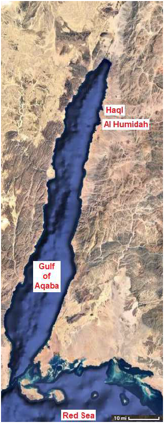
The modern Route 65 road runs in the Arabah valley from the Dead Sea to the Gulf of Aqaba. This modern road carries on southward, no longer designated Route 65, along the east side of the Gulf of Aqaba until it turns southeast at Al Humidah to cross the mountains (Figure 4). It thus appears that Ezion-geber should be sought in the vicinity of Al Humidah.
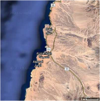 |
I propose that the modern coastal town of Haql, Saudi Arabia, at Google Maps coordinates (29.285, 34.948), just two or three miles north of Al Humidah (Figures 4 and 5), corresponds to Ezion-geber, and that Al Humidah corresponds to Elath. To the best of my knowledge, this is the first time these locations for Ezion-geber and Elath have been proposed.
 |
In the geographical context of Al Humidah, it appears that the ancient biblical town of Elath should be seen primarily as a way station at the intersection of the ancient Arabah Road, which ran to the north from modern Al Humidah, and the road over the mountains to the southeast. Elath would have served to provide food, drink, temporary lodging, and general provisions for travelers upon these roads.
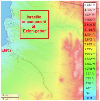
Meanwhile, Ezion-geber should be seen, in the context of the Exodus, primarily as a place suitable for a 25 square mile campground.
The coastal plain running along the northeast side of the Gulf of Aqaba is widest at Haql and Al Humidah, providing sufficient room for such a campsite (Figure 6). I suggest that the Israelite encampment was centered on the wadi which empties into the Gulf of Aqaba at Haql, just as we have previously seen was the case for the encampment at Etham.[12]
 |
Google Maps shows that this wadi originates miles back up in the mountains. In the less arid climate which pertained at the time of the Exodus, this wadi would have sustained a flow of fresh water for a larger part of the year than pertains today. We may presume that the Israelites' stay at Ezion-geber would have coincided with that portion of the year during which this wadi would have been able to supply the camp with a continuous supply of fresh water, as it seems probable that the departure from Sinai would have been timed to correspond to the months of greatest rainfall in the Negev.
For Haql to correspond to Ezion-geber, the coastline at Haql needs to be suitably shaped for a harbor. Ports are generally situated in harbors, the harbor providing some measure of protection for the boats from the waves coming into the shore from the open sea.
Overall, the Gulf of Aqaba coastline sports little by way of natural indentations suitable for harborage. Haql is an exception. It appears that boats moored along the southwestern corner of its indentation would be reasonably well protected.
Zooming in via Google Maps confirms this speculation. Figure 7 shows that a port exists in this spot at Haql today.
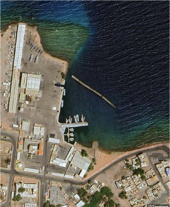 |
I suggest that this modern port is a descendant of Solomon's port, built in this same location three thousand years ago—that modern Haql corresponds to ancient Ezion-geber. ◇
The Biblical Chronologist is written and edited by Gerald E. Aardsma, a Ph.D. scientist (nuclear physics) with special background in radioisotopic dating methods such as radiocarbon. The Biblical Chronologist has a fourfold purpose:
The Biblical Chronologist (ISSN 1081-762X) is published by: Aardsma Research & Publishing Copyright © 2024 by Aardsma Research & Publishing. Scripture quotations taken from the (NASB®) New American Standard Bible®, Copyright© 1960, 1971, 1977, 1995 by The Lockman Foundation. Used by permission. All rights reserved. www.Lockman.org } |
^ Gerald E. Aardsma, "The Route of the Exodus, Part V: The Location of Kadesh-barnea," The Biblical Chronologist 13.4 (March 28, 2023): 1–6. www.BiblicalChronologist.org.
^ Gerald E. Aardsma, "The Route of the Exodus, Part VII: The Location of Mount Hor," The Biblical Chronologist 13.7 (September 8, 2023): 1–10. www.BiblicalChronologist.org.
^ The NASB (1975) spelling of this town is "Eloth" in this verse as well as 2 Chronicles 8:17 and 2 Chronicles 26:2, while it is spelled "Elath" in Deuteronomy 2:8, 2 Kings 14:22, and 2 Kings 16:6. That both spellings refer to the same place is made clear by its close proximity to Ezion-geber both as "Elath" in Deuteronomy 2:8 and as "Eloth" in this verse. Regardless of spelling, note that the place referred to should not to be confused with the similar-sounding modern city of Eilat at the tip of the Gulf of Aqaba. Eilat has no archaeological link of any sort to the ancient biblical town of Elath/Eloth.
^ Other biblical historical references to Ezion-geber as a seaport include 1 Kings 22:48, 2 Chronicles 8:17, and 2 Chronicles 20:36.
^ Gerald E. Aardsma, "The Route of the Exodus, Part VII: The Location of Mount Hor," The Biblical Chronologist 13.7 (September 8, 2023): 2, Figure 2. www.BiblicalChronologist.org.
^ en.wikipedia.org//wiki/Ezion-Geber (accessed January 13, 2024).
^ Gerald E. Aardsma, "Yeroham: the True Mount Sinai," The Biblical Chronologist 6.4 (July/August 2000): 1–11. www.BiblicalChronologist.org.
^ Gerald E. Aardsma, "The Route of the Exodus, Part V: The Location of Kadesh-barnea," The Biblical Chronologist 13.4 (March 28, 2023): 1–6. www.BiblicalChronologist.org.
^ Gerald E. Aardsma, "The Route of the Exodus, Part V: The Location of Kadesh-barnea," The Biblical Chronologist 13.4 (March 28, 2023): 6, Figure 7. www.BiblicalChronologist.org.
^ Figure 2 shows that the driving distance from Yeroham to Tabuk is 494 km. From Yeroham through Dimona to Eilat, on the Gulf of Aqaba, is 224 km.
^ Gerald E. Aardsma, "Understanding the Pillar of Cloud," The Biblical Chronologist 13.8 (November 15, 2023): 6. www.BiblicalChronologist.org.
^ Gerald E. Aardsma, "The Route of the Exodus, Part II: The Encampment at Etham," The Biblical Chronologist 13.1 (February 7, 2023): 1–5. www.BiblicalChronologist.org.