
| |
| Volume 14, Number 3 | February 6, 2024 |
Numbers 33 gives an exhaustive list of Israelite Exodus encampments from Egypt to the east side of the Jordan river where the Eviction/Conquest would begin. The list is compact and to the point, with few details. From this list we learn that the wilderness of Sin encampment was the seventh after leaving Egypt. The encampment is not given any name. It is referenced rather, in verses 11 and 12, merely by its location, "in the wilderness of Sin."
The objective, this issue, is to pinpoint, as much as possible, the location of the Israelites' wilderness of Sin encampment.
In contrast to the brevity of Numbers 33, the biblical book of Exodus majors on details.
The "wilderness of Sin" is explicitly mentioned in connection with the arrival of the Israelites there, in Exodus 16:1, and again on their departure, in Exodus 17:1.
From Exodus 16:1, we learn that the Israelites arrived in the wilderness of Sin two and a half months after leaving Egypt. This yields an average stay of about 12 days per encampment up to that point in their journey.
The wilderness of Sin encampment has some special historical significance associated with it, because it was at this site that manna first appeared. Indeed, Exodus 16 is pretty much all about manna. Unfortunately, for the present purpose, it is difficult to see how one might pinpoint the encampment site working from the Exodus 16 record of the advent of manna.
Beyond this, no details of the stay at the encampment in the wilderness of Sin are provided by any other portion of the biblical historical record of the Exodus.
Thus, the best hope of locating this encampment appears to be via properly locating the wilderness of Sin itself.
The wilderness of Sin is the third wilderness to be mentioned in connection with the route of the Exodus (Table 1).
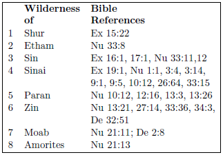 |
Last issue, we looked at the first two wildernesses in this table: the wilderness of Shur and the wilderness of Etham.[1] These were both seen to be rather large wildernesses. Either of them might easily swallow up over a hundred encampment sites. This may make the effort to pinpoint the wilderness of Sin encampment by locating the wilderness of Sin seem a bit futile, but any such pessimism fails to give due credit to the biblical historical record.
The text explicitly tells us that the exhaustive list of sites in Numbers 11 was made at the command of God.
These are the journeys of the sons of Israel, by which they came out from the land of Egypt by their armies, under the leadership of Moses and Aaron. And Moses recorded their starting places according to their journeys by the command of the Lord, and these are their journeys according to their starting places. (Numbers 33:1–2)Moses could not faithfully fulfill this command by writing, "then we camped in the wilderness of Etham" or "then we camped in the Negev desert." These designations would obviously fail to fulfill the command because they are not specific enough.
Inverting this logic, we may evidently conclude that the wilderness of Sin was small enough that locating it would automatically make the encampment site obvious. The easiest way for this to happen would be if the wilderness of Sin were only large enough to fit a single encampment site. Thus, we seem, in this instance, to be looking for a relatively small wilderness.
Another potentially helpful hint from the study last issue was the observation that wildernesses do not seem to have been given a name of their own back at the time of the Exodus, but rather were referenced by some named object to which they were adjacent. The wilderness of Shur was the wilderness which lay to the east and south of the city of Shur. Etham seems to have been the name of the estuary, active back at the time of the Exodus but no longer active today, of what today is called the Nitzana River. The bed of the Nitzana River runs back up into the highlands southeast of Etham, making the wilderness of Etham to be the wilderness which lay to the west, to the south, and especially to the southeast of Etham. Thus it seems that, if we could identify Sin itself on a map, then the location of the wilderness of Sin would easily follow.
Unfortunately, it is not at all obvious from the Bible what the object named "Sin" was. The biblical narrative of the Exodus sheds no light at all on this question. At a very much later time in history—the better part of two thousand years later—Ezekiel mentions a city of Sin existing in Egypt during his time.[2] But this city is far removed both in time and in space from the context of the Israelite encampment in the wilderness of Sin. Note that, at the point when the wilderness of Sin is mentioned in the historical narrative of the Exodus, the Israelites are located in the Negev Desert, not back in Egypt.
That the word "Sin" is also present in "Sinai" leads to the speculation that both names may have some common source, especially as the wilderness of Sin is not far removed from Mount Sinai, as we will see below. But Strong's Concordance informs us that both "Sin" and "Sinai" are of uncertain derivation, bringing this speculation to an apparent dead end as far as linguistic investigation is concerned.
Fortunately, the biblical text, while providing no help with the meaning of the proper noun "Sin," does offer assistance—essential to cracking this particular mystery—with the wilderness of Sin itself. It tells us where this wilderness is located.
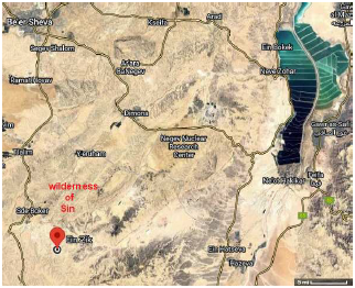
Then they set out from Elim, and all the congregation of the sons of Israel came to the wilderness of Sin, which is between Elim and Sinai, … (Exodus 16: 1a)This opens the door to a modern topographical line of inquiry.
We know where Elim is located.[3] The ancient Elim is today called Ein Ziq. It can be located on Google Maps via coordinates (30.796, 34.851).
The fact that Ein Ziq/Elim is located in the Zin Valley may seem immediately encouraging, there being a clear phonetic similarity between "Zin" and "Sin." But this similarity appears to be purely coincidental. Zin appears to be a modern name assignment for the region.[4] This assignment seems likely to have been inspired by the misidentification of this region as the actual biblical wilderness of Zin—mentioned later in the Exodus narrative—which it most certainly is not. The biblical wilderness of Zin is associated with Kadesh-barnea, which we now know is far removed from Ein Ziq/Elim, away to the southeast, at Tabuk, Saudi Arabia.[5]
We also know where Mount Sinai is located.[6] It corresponds to the modern mountain at Yeroham, with Google Maps coordinates for the present summit of the mountain of (30.956, 34.866).
Now Ein Ziq/Elim and the summit of the Yeroham/Sinai mountain are not too far apart—just 13 miles. Meanwhile, we learned from the encampment at Etham that encampments were normally about 25 square miles, which is a square 5 miles on a side. Thus, the knowledge of these two locations, Ein Ziq/Elim and Yeroham/Sinai, immediately allows the rough location of the wilderness of Sin to be identified. In Figure 1, I simply placed the wilderness of Sin midway between Ein Ziq and Yeroham (spelled Yeruham on the map) in accordance with Exodus 16:1.
 |
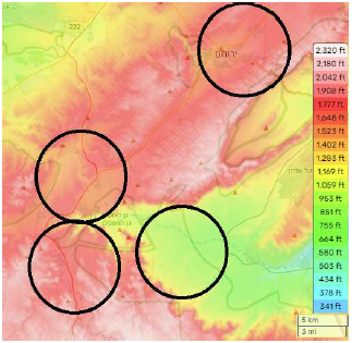
To go beyond this rough location of the wilderness of Sin, it is necessary both to zoom in and to switch to a topographical map of the region. The purpose in doing so is to figure out where the encampment would have been. The terrain is fairly rough in this region, not a wide open plain. We have seen, above, that the region in question is not very large relative to the size of a typical encampment. Is there a large flat piece of ground where the Israelites could set up camp in this general region?
Figure 2 zooms in by roughly a factor of two relative to Figure 1. The black circles are drawn by me. They circle an area of 25 square miles, the rough size of an Israelite encampment. An encampment could be smaller or larger than this—the Israelites could obviously pitch their tents closer together or farther apart, depending upon available space. Also, these circles are not meant to imply that encampments were circular. Encampments from Sinai on seem, in fact, to have been rectilinear. The circles are meant simply to show the rough area needed in each of these rough locations. The encampment corresponding to each circle is shown in the caption. I have not labeled these in this figure to avoid obscuring the topography. The main thing to notice at this point is that there is only one location where the wilderness of Sin encampment can be squeezed in, as was previously surmised likely to be the case.
 |
The second thing to notice (Figure 3) is that Moses evidently did not mean that the wilderness of Sin was geometrically between Elim and Sinai. He meant that the wilderness of Sin is geographically between Elim and Sinai. Ein Ziq/Elim is down in the canyon, at about 880 feet elevation. The encampment at Yeroham/Sinai is at about 1,600 feet elevation. There is a cliff between Ein Ziq/Elim and Yeroham/Sinai. To travel to Yeroham/Sinai from Ein Ziq/Elim on foot, one would want first to travel west, to get up out of the canyon, and then to travel northeast, to get to Yeroham/Sinai. In the process, one would pass through the wilderness of Sin.
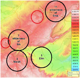 |
It is now possible to make a reasonable guess at what "Sin" is. I suggest that, like "Sinai," the name "Sin" refers to a mountain peak. Specifically, I suggest that it refers to the peak with the smaller red circle around it (drawn by me) in Figure 3.
This peak's summit has an elevation of about 2,080 feet. By comparison, the summit of Sinai has an elevation of about 2,110 feet. (This is the height of the summit of Sinai today. It may have been higher or lower prior to the recorded historical incident in which God descended upon Mount Sinai in fire (Exodus 19:7–20). The topographical maps of Figures 2 and 3 both reveal the large crater, over a mile across, and its drainage channel to the northwest, which exist on Mount Sinai today in consequence of that theophonic impact event.[7] The rims of impact craters are frequently elevated relative to the initial landscape by an overturned flap of earth, caused by the impact explosion.)
The proposed "Sin" peak stands alone, so it would be conspicuous—a suitable landmark—from the wilderness of Sin which lay at its feet. ◇
The Biblical Chronologist is written and edited by Gerald E. Aardsma, a Ph.D. scientist (nuclear physics) with special background in radioisotopic dating methods such as radiocarbon. The Biblical Chronologist has a fourfold purpose:
The Biblical Chronologist (ISSN 1081-762X) is published by: Aardsma Research & Publishing Copyright © 2024 by Aardsma Research & Publishing. Scripture quotations taken from the (NASB®) New American Standard Bible®, Copyright© 1960, 1971, 1977, 1995 by The Lockman Foundation. Used by permission. All rights reserved. www.Lockman.org } |
^ Gerald E. Aardsma, "The Locations of the Wilderness of Shur, the City of Shur, and the Wilderness of Etham," The Biblical Chronologist 14.2 (January 30, 2024): 1–6. www.BiblicalChronologist.org.
^ Ezekiel 30:15–16.
^ Gerald E. Aardsma, "The Route of the Exodus, Part III: The Location of Elim," The Biblical Chronologist 13.2 (February 16, 2023): 1–4. www.BiblicalChronologist.org.
^ en.wikipedia.org/wiki/Zin_desert (accessed January 24, 2024).
^ Gerald E. Aardsma, "The Route of the Exodus, Part V: The Location of Kadesh-barnea," The Biblical Chronologist 13.4 (March 28, 2023): 1–6. www.BiblicalChronologist.org.
^ Gerald E. Aardsma, "Yeroham: the True Mount Sinai," The Biblical Chronologist 6.4 (July/August 2000): 1–11. www.BiblicalChronologist.org.
^ Gerald E. Aardsma, "The Crater at Mt. Yeroham – Part I," The Biblical Chronologist 9.1 (May 2008): 1–7. www.BiblicalChronologist.org.