
| |
| Volume 14, Number 4 | February 13, 2024 |
The sixth encampment of the Israelites after leaving Egypt is not designated by a name. It is listed in Numbers 33 merely as having been "by the Red Sea."
And they journeyed from Marah, and came to Elim; and in Elim there were twelve springs of water and seventy palm trees; and they camped there. And they journeyed from Elim and camped by the Red Sea. And they journeyed from the Red Sea, and camped in the wilderness of Sin. (Numbers 33:9–11)This issue, the objective is to pinpoint the location of this "Red Sea" encampment.
The greatest obstacle to reaching this objective is the notion that this encampment was somewhere on the shoreline of the Red Sea. It wasn't. "Red Sea" is a mistaken translation of the original Hebrew "yam suph" in this verse.
Last issue, we saw that the Numbers 33 list of encampments was compiled at the command of God. We saw that sufficiently specific designators of the individual encampments in this list are essential to fulfillment of this command.
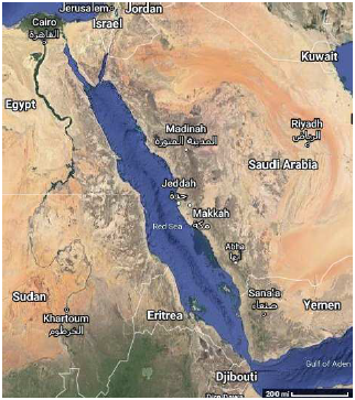
The modern Red Sea is anything but specific in this regard. Its shoreline extends for hundreds and hundreds of miles (Figure 1). The Red Sea is logically forbidden in this list, just as much as the Negev Desert, or Canaan, or Egypt, or Africa is forbidden in this list. These designators lack sufficient geographical specificity to serve the intended purpose of this list.
 |
The NASB, used for the English translation of the verses above, provides a helpful marginal note clarifying that "yam suph" is, "Literally, Sea of Reeds."
The way "yam suph" is used within the Exodus narrative suggests that we need to go one step further and remove the capital letters from "Sea of Reeds." It appears that a name—a proper noun—is not intended when these words are used within the Exodus narrative. This is seen as follows.
We now know that "yam suph" is used of several different bodies of water in the Bible.
We have seen one yam suph in connection with the "Red Sea" crossing.[1] The "Red Sea" in that instance, we now know, is a reference to Lake Bardawil at the north end of the Sinai Peninsula, bordering the Mediterranean Sea.
We have recently seen a second yam suph, from a much later time, in connection with Solomon's port on the "Red Sea" at Ezion-geber.[2] This port is far to the south, on the east shoreline of the Gulf of Aqaba, an extension of what is called the Red Sea today.
Now we are seeing a third yam suph in connection with this "Red Sea" encampment site in the central Negev.
There cannot be three distinct bodies of water, all in the same general geographical region, all named "Red Sea."
So it appears that we must understand "sea of reeds," as it appears in the Exodus narrative, to be in the common noun category, like "mountain" or "tree," not the proper noun category.
When we go the extra step of removing the capitals, the translation of the original Hebrew of Numbers 33:9–11 becomes:
And they journeyed from Marah, and came to Elim; and in Elim there were twelve springs of water and seventy palm trees; and they camped there. And they journeyed from Elim and camped by the sea of reeds. And they journeyed from the sea of reeds, and camped in the wilderness of Sin.
In contrast to "the Red Sea," "the sea of reeds" is appropriate to the purpose of the Numbers 33 list. It specifies one particular sea of reeds. Moses is communicating that after Elim and before the wilderness of Sin, they camped by a sea of reeds, but it is designated the sea of reeds, not a sea of reeds. The definite article is appropriate—indeed essential—to the purpose of the list. The particular sea of reeds referred to is understood to be a landmark in its geographical context. They did not camp by a sea of reeds—by just any sea of reeds. They camped by the sea of reeds—the one which was a conspicuous landmark in the general vicinity of Elim and the wilderness of Sin.
To find the "Red Sea" encampment, we need to find this landmark sea of reeds.
We are significantly helped in this endeavor by the first occurrence of "Red Sea" (yam suph) in the Exodus narrative, mentioned above. The sea of reeds in this case is the one related to the "Red Sea" (yam suph) crossing. It shows up first in the Exodus narrative in connection with the road the Israelites took out of Egypt.
Hence God led the people around by the way of the wilderness to the Red Sea; and the sons of Israel went up in martial array from the land of Egypt.I have previously discussed this "way of the wilderness to the Red Sea" in some detail.[3] The important point, in the present context, is that this sea of reeds corresponds to the modern Lake Bardawil. Thus, modern Lake Bardawil gives us some idea of the sort of thing for which we should be looking.
Most fundamentally, a "sea" is expected to be a body of salt water. Lake Bardawil is certainly that. Lake Bardawil is observed to be highly saline today.
Given this much, the further expectation is that a "sea of reeds" should display a conspicuous presence of reeds. But here we encounter an apparent snag. Lake Bardawil—judging from close-up photos of its shoreline, obtained by searching "Lake Bardawil" on Google Maps—displays few, if any, reeds growing around it today.
This is not a real snag. The climate of the region, as we have repeatedly seen in this series, is more arid today than it was back at the time of the Exodus. Reeds are freshwater plants, not saltwater plants. To get a saltwater sea of reeds, one needs to have a significant freshwater input along the shore of the saltwater lake. This freshwater input may be in the form of rainfall or natural runoff. Today, the region is desert, and the needed freshwater input for growth of reeds is severely attenuated relative to 2450 B.C., when the Exodus happened.
It appears that, while the saltwater lake present at the time of the Exodus yet exists at Lake Bardawil, the reeds which existed in the region back at that time, four and a half thousand years ago, subsequently ceased to exist there when the climate in that region became more arid.
Thus, we are not looking for a lot of reeds today in our quest for the "Red Sea" encampment. Indeed, as it turns out, not even the original saltwater lake of the sea of reeds by this encampment remains at present. Nevertheless, it is not difficult to pick out where this sea of reeds must have been located.
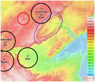
I suggest that the sea of reeds referred to in Numbers 33:10–11 existed within Makhtesh Yeruham[4] back at the time of the Exodus (Figure 2). To see this, it is first of all important to know what a makhtesh is.
A makhtesh … is a geological landform considered typical for the Negev desert of Israel and the Sinai peninsula of Egypt. A makhtesh has steep walls of resistant rock surrounding a deep closed valley, which is usually drained by a single wadi.[5]
 |
The walls of a makhtesh resemble crater walls, but a makhtesh is formed in a way that is entirely different from the way a crater is formed.
Where a hard outer layer of rock covers softer rocks, erosion removes the softer minerals relatively quickly, and they are washed away from under the harder rock. The harder rocks eventually collapse under their own weight, and a crater-like valley structure is formed. In Negev and Sinai makhteshes, the hard rocks are limestone and dolomites, while the inner softer rocks are chalk or sandstone.[6]
Today, the dry floor of Makhtesh Yeruham tilts downward toward the northeast corner. Runoff from rainfall inside the makhtesh drains out the northeast corner via Nahal Hatira. I suggest that this drainage outlet was not so deeply cut through the wall of the makhtesh back at the time of the Exodus as it is today—that, in 2450 B.C., there was a natural dam creating a shallow saltwater lake within the makhtesh.
As with the wilderness of Sin encampment, there appears to be only one suitable location for an encampment next to Makhtesh Yeruham (Figure 3).
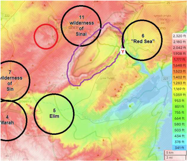 |
The still active, nearby spring of Ein Yorkeam (also spelled Yorke'am) would have provided this encampment site with a supply of fresh water. It still sports reeds today.
Ein Yorkeam is a large, beautiful spring that is part of the Hatira Stream. Immediately after the spring the canyon aspect of the stream becomes very pronounced. The spring is hidden under a deep dorsum that floods the entire area in the winter. Around the spring is bountiful flora, such as reeds and tamarisks.[7]
The error of uniformly translating "yam suph" as "Red Sea" plagues the Exodus narrative. It has done so for a very long time. "Red Sea" has been the traditional translation of "yam suph" at least as far back as the Septuagint, a translation of the Old Testament from Hebrew to Greek made several centuries before the birth of Christ. It now seems possible to reconstruct how this error may have come about.
As shared above, I find that the natural translation of "yam suph," as it appears in the Exodus narrative, is "sea of reeds," and that a sea of reeds is naturally defined as a saltwater lake having a conspicuous presence of reeds round about it.
The use of "yam suph" in connection with Solomon's port at Ezion-geber does not conform to this definition.
King Solomon also built a fleet of ships in Ezion-geber, which is near Eloth [Elath] on the shore of the Red Sea [yam suph], in the land of Edom. (1 Kings 9:26)This port, we now know, was not on a brackish lake surrounded by freshwater reeds. It was on the shore of the extension of the Red Sea known today as the Gulf of Aqaba.[8]
I suggest that this departure from the definition of a reed sea happens because, by Solomon's time, one and a half thousand years after the Exodus, the modern Gulf of Aqaba, the sea on which Ezion-geber is located, had, in fact, acquired the name "Sea of Reeds."
A map of the head of the Gulf of Aqaba made in 1822 by the first modern foreigner to visit the area places a "brackish marsh" on the north end of the Gulf of Aqaba, where it meets the Arabah Valley.[9] In less arid conditions of earlier times, this would have been a freshwater marsh, yielding several square miles of reeds at the head of the Gulf of Aqaba. This may have motivated the name "Sea of Reeds" in antiquity for what is now called the Gulf of Aqaba, causing Sea of Reeds to be its name in Solomon's time.
If this conjecture is correct, then "Sea of Reeds" (rather than "sea of reeds") is, in fact, the intended meaning of "yam suph" in 1 Kings 9:26.
I suggest that translators who lived only hundreds of years after Solomon, such as those involved with the Septuagint, would have had a good chance of knowing the correct location of Ezion-Geber. The sea on which Ezion-geber was located was known to them as the Red Sea. This gave them the apparent equivalence:
"yam suph" = "Red Sea"They then applied this uniformly to all occurrences of "yam suph" within the Hebrew text they were translating, resulting in a lot of instances of "Red Sea" in our modern Bibles where the original Hebrew meant "sea of reeds."[10] ◇
The Biblical Chronologist is written and edited by Gerald E. Aardsma, a Ph.D. scientist (nuclear physics) with special background in radioisotopic dating methods such as radiocarbon. The Biblical Chronologist has a fourfold purpose:
The Biblical Chronologist (ISSN 1081-762X) is published by: Aardsma Research & Publishing Copyright © 2024 by Aardsma Research & Publishing. Scripture quotations taken from the (NASB®) New American Standard Bible®, Copyright© 1960, 1971, 1977, 1995 by The Lockman Foundation. Used by permission. All rights reserved. www.Lockman.org } |
^ Gerald E. Aardsma, The Exodus Happened 2450 B.C. (Loda, IL: Aardsma Research and Publishing, 2008). www.BiblicalChronologist.org.
^ Gerald E. Aardsma, "The Route of the Exodus, Part VIII: The Location of Ezion-geber (and Elath)," The Biblical Chronologist 14.1 (January 01, 2024): 1–6. www.BiblicalChronologist.org.
^ Gerald E. Aardsma, The Exodus Happened 2450 B.C. (Loda, IL: Aardsma Research and Publishing, 2008), 71–75. www.BiblicalChronologist.org.
^ Makhtesh Yeruham has other names, and Yeruham may also be spelled Yeroham. When the topographical map featured in Figure 2 is zoomed in, a name appears in Hebrew that means Great Crater Nature Reserve, where the "Great Crater" part is HaMakhtesh HaGadol, one of the alternate names. Others include Makhtesh HaGadol and Makhtesh Gadol. en.wikipedia.org/wiki/HaMakhtesh_HaGadol (accessed February 12, 2024.)
^ en.wikipedia.org/wiki/Makhtesh (accessed February 7, 2024).
^ en.wikipedia.org/wiki/Makhtesh (accessed February 7, 2024).
^ Charlotte Noris, September 2, 2012, israeltripplanner .com/southern-israel/nature-parks-negev/ein-yorkeam (accessed February 7, 2024).
^ Gerald E. Aardsma, "The Route of the Exodus, Part VIII: The Location of Ezion-geber (and Elath)," The Biblical Chronologist 14.1 (January 01, 2024): 1–6. www.BiblicalChronologist.org.
^ en.wikipedia.org/wiki/Eilat (accessed February 8, 2024).
^ Tom Godfrey (PhD linguistics) provided the following helpful comment while reviewing a pre-publication draft of this issue. "You might want to mention somewhere that our oldest Hebrew manuscripts make no distinction between upper case (capitalized) and lower case letters (https://how-ocr-works.com/languages/hebrew-alphabet.html), so our modern convention for showing the difference between red river boat and Red River boat or between sea of reeds and Sea of Reeds was not available. Readers relied on context alone."