
| |
| Volume 3, Number 2 | March/April 1997 |
Did Noah's ark come to rest on Mount Ararat?
Before delving into this question it is perhaps important to address another question: "What difference does it make to Biblical chronology where the ark landed?"
Actually, it makes quite a bit of difference at the present time.
Biblical chronology research over the past several years has repeatedly indicated that 3520±21 B.C. is the proper date for Noah's Flood. This is the date one calculates for the Flood from the Bible when allowance is made for an accidentally dropped "one thousand" years from the text of extant Old Testament manuscripts of 1 Kings 6:1.[1] The evidence from Biblical archaeology and secular history is such that sane reasoning can only conclude that this "one thousand" has indeed been dropped. When no allowance is made for it, archaeological data are severely at odds with the Biblical narrative prior to the time of King David, and sacred and secular histories of all earlier periods prove irreconcilable. In sharp contrast, when allowance is made for this "one thousand" Biblical history immediately harmonizes with archaeology and secular history—as practically every issue of The Biblical Chronologist has shown.
I have previously shown that this is also the case with the Flood. While dates for the Flood in the third millennium B.C. (what one gets if the missing "one thousand" is ignored) range from preposterous to impossible when assessed relative to available archaeological data, 3520±21 B.C. (what one gets if the missing "one thousand" is taken into account) works out very well. Most importantly, it coincides with the sudden disappearance of Chalcolithic peoples in Palestine and elsewhere in the Middle East.[2]
Please note that evidence for an abrupt termination of human civilization is the most fundamental requirement of the Biblical account of the Flood. That, after all, the Bible informs us, is what the Flood was fundamentally about. If no secular evidence of such a termination could be found near 3520 B.C. then either this Biblical date, or the historicity of the Biblical Flood account would necessarily be called into serious question.
But no such problem arises. Biblical archaeology immediately reveals a widespread discontinuity in human civilization within dating uncertainties of 3520 B.C.—in sharp contrast to the obvious continuity of civilization from that time to the present.
In addition, Biblical archaeology and secular history reveal that it is only subsequent to this date that political units such as kingdoms and city-states begin to be seen. This is of considerable significance. The Bible places the origin of human government in a Divine decree given to Noah following the Flood.[3] Thus, the Bible leads us to expect that human government will be a part of human societies only following the Flood. Kingdoms and city-states are very clear manifestations of human government. Their total absence before 3500 B.C., and ubiquitous presence by 3000 B.C. strongly support the 3520 B.C. date for the Flood and argue against the idea that the Flood should be dated to any other millennium.
Clearly, as far as archaeology and secular history are concerned, there are some solid reasons for accepting a date for the Flood near 3500 B.C.
But there is another requirement of a fundamental sort, in addition to an abrupt termination of human civilization and the origin of human government, which the Biblical account of the Flood places on any proposed date for the Flood. This requirement does not fall within the scope of archaeology, but rather geology.
The Bible is quite clear that the Flood achieved great depth, so that mountains were covered.[4] The Bible is also quite clear that the Flood lasted for the better part of a year.[5] It is impossible, in the real world, to cover mountains with water for a number of months and leave no detectable trace that such a thing has happened. Stated simply, if Noah's Flood happened 3520±21 B.C., then geological evidence of such an event at this date should be forthcoming.
Now let me digress briefly. One does not have to read very much in the history of the science of geology to know that this problem—the geologic evidence for Noah's Flood—was of very great interest and concern to geological scholars a century or two ago. And one does not have to read very far in the modern geological literature—any college textbook will do—to see that Noah's Flood is of no interest at all to the modern discipline. It is thus a fact that, despite considerable effort, leading geologists failed to find a place for the Flood within their scientifically rigorous discipline.
Now the impact of Noah's Flood on the history of geology is of academic interest only. But not so the impact of the science of geology on mankind's perception of Noah's Flood. Geology's sustained failure to find any effects which might reasonably be ascribed to the Flood has seemed to falsify the Genesis account of that event. Since one cannot hope to convict the Bible of falsehood in matters of mundane history and simultaneously sustain any intelligent confidence in it as a divinely inspired holy book, it is hardly surprising that many have traced the now advanced secularization of Western civilization to this geological failure.
I mention this merely to point out that here again the humble and, these days, generally overlooked discipline of Biblical chronology seems to be at the root of much bigger things. Clearly, geological confirmation of the new Biblical date for Noah's Flood has implications well beyond the boundaries of the discipline of Biblical chronology.
But let me return to the main point. The direction of Biblical chronology research over the past several years leads us to expect geological confirmation of Noah's Flood within secular dating uncertainties of 3520±21 B.C.
I have recently shown what I believe to be the first such evidence. Specifically, laminated sediments from Elk Lake in Minnesota show a very thick and otherwise anomalous layer in coincidence with this date.[6]
This discovery leads immediately to the question, "Can the Elk Lake evidence for a global Flood at about 3500 B.C. be corroborated in other natural reservoirs of chronologically well-controlled data?" Ability to answer this question in the affirmative will satisfy the geological requirement for this date—showing that the Elk Lake evidence does not arise by mere chance or coincidence—and place this date for the Flood on a very firm footing.
To aid in answering this question I set about, several months ago, to construct a graph of the depth of the Flood versus time. Such a graph would help to determine much about the potential impact of the Flood in various geological reservoirs. It would assist in deciding where to look for further geological evidence of the Flood, and it would assist in correctly interpreting whatever evidence might be found in such reservoirs.
It was clear from the start that such a graph could only be gotten, if at all, from the Genesis narrative of the Flood.
When I turned to Genesis I quickly found that it does provide some potentially important depth of water versus time data, but I also quickly found that one must possess an accurate knowledge of where the ark came to rest for these Biblical data to be of much value.
For example, the Biblical narrative indicates that the ark came to rest on a mountain on the 150th day after the commencement of the Flood. If we knew which mountain this was, then the present height of that mountain should provide a very good estimate of the depth of the Flood on Day 150 of the Flood. As a further example, the Genesis narrative informs us that the tops of neighboring mountains became visible on Day 222 of the Flood. Once again, if the mountain the ark landed on could be determined, then the measured heights of the neighboring mountains today would provide us with a fair estimate of the depth of the Flood on Day 222.
Thus, if the mountain Noah's ark came to rest upon could be accurately determined it would help us to know how deep the water was at various stages of the Flood. This in turn would help us to know where to look and what to look for as we search for additional geological evidences of Noah's Flood at about 3500 B.C. And discovery of such evidences would confirm the new Biblical date for the Flood of 3520±21 B.C., a vital step in current Biblical chronology research.
Tradition says the ark landed on Mount Ararat, the tallest peak in modern Turkey (Figure 1).
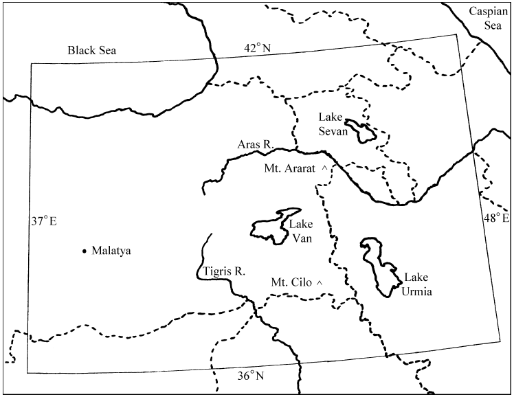 |
But tradition has not proved to be an always reliable guide to ancient Biblical sites. I have previously argued, for example, that it has clearly misidentified the site of the Biblical Mount Sinai.[7] Furthermore, numerous expeditions to Mount Ararat to search for remains of the ark have so far failed to come up with anything convincing—despite some claims to the contrary.[8] For the present purpose one needs something more substantial than tradition to go on.
It is commonly believed that the Bible tells us directly that the ark landed on Mount Ararat. In point of fact, however, it does not do so.
In Genesis 8:4 the Bible records that "the ark rested upon the mountains of Ararat". Bible scholars observe that the use of the plural—mountains—precludes the identification of any particular mountain by the Bible writer.[9] Rather, they suggest, "the mountains of Ararat" should be understood as referring to a mountainous area in a region known as Ararat. Correct interpretation of Genesis 8:4 seems to demand we accept that the Bible is not referring to a specific mountain, but rather to a geographical region when it mentions the resting place of the ark.
Where is this region called Ararat to be found on the globe? If the Bible does not tell us directly which mountain the ark landed on, might it nonetheless help us locate the general area in which the ark came to rest?
"Ararat" is mentioned three times in the Old Testament in addition to Genesis 8:4. Unfortunately, these references are not very helpful in and of themselves when it comes to the problem of locating this region. The first two are parallel accounts in 2 Kings 19:37 and Isaiah 37:38 which mention "the land of Ararat" but do not tell us where that land is. The third (Jeremiah 51:27) is a prophecy against Babylon which mentions the "kingdoms of Ararat, Minni and Ashkenaz". Here again no specific geographical details are provided.
Apparently, no direct indication of the location of the Ararat region is to be found in the Bible. But these Bible references do increase our knowledge of the meaning of the word "Ararat" as it is used in the Bible. They show that "Ararat" is indeed a reference to a region (a "land") rather than a specific mountain. They also show that, at least during the time of Jeremiah (approximately 600 B.C.), a kingdom of Ararat was known. And Genesis 8:4 adds to this the expectation that the Ararat region contained a mountainous area.
Genesis 11:2 provides some important indirect Biblical evidence regarding the location of Ararat. It informs us that the descendants of Noah came into the land of Shinar (which we understand to be the plain between the Tigris and Euphrates rivers in Mesopotamia) "as they journeyed east". This would place the region of Ararat to the west of Shinar. Unfortunately, this geographical hint is complicated by the Septuagint rendering of this verse which reads "as they moved from the east". This would put Ararat in the opposite direction, to the east of Shinar.
It seems necessary to conclude that the location of the Ararat region cannot be ascertained with any certainty from the Bible alone.
The most direct link to the location of the Ararat region seems to come about through a combination of Biblical and archaeological data. Specifically, an independent kingdom known to the Assyrians as Urartu was familiar to the Assyrians as a neighbor and enemy from about 850 B.C. Urartu is known from archaeological and historical data to have been located in the vicinity of Lake Van in modern Turkey (Figure 1).
The kingdom of Urartu seems to be the only possible candidate for the kingdom of Ararat which Jeremiah mentions. In addition to this archaeological lead it should be noted that the geographical region associated with Urartu encompasses the traditional Mount Ararat. This tells us that Christians, for many centuries at least, have, for whatever reasons, held this to be the Ararat region. Furthermore, this region seems to best satisfy the Biblical evidence. It contains many mountains. It is also the region from which the Tigris river begins, making it easy to see how Noah's descendants could have come upon the land of Shinar by following the southeastward course of this river.
By taking these Biblical and archaeological facts into consideration, scholars seem to have come more or less unanimously to the conclusion that the Ararat region corresponds roughly to eastern Turkey today:
A country in the region of Lake Van in Armenia, where today the borders of Russia, Iran, and Turkey converge.[10]
A country in [the historical] Armenia, its center being Lake Van.[11]
The name Ararat, as it appears in the Bible, is the Hebrew equivalent of Urardhu, or Urartu, the Assyro-Babylonian name of a kingdom that flourished between the Aras and the Upper Tigris rivers from the 9th to the 7th century BC.[12]
Spreading northwestward [from the region of Lake Van] into Transcaucasia, Urartu extended its settlements to the region of Mount Ararat, the valley of Araxes (modern Aras), and Lake Sevan, and westward, for a time, as far as Melitene (modern Malatya).[13]
The general region indicated by these scholars is shown in the map of Figure 1. The area bounded by longitudes 37°E on the west and 48°E on the east, and latitudes 36°N on the south and 42°N on the north includes Lake Van, Malatya, Lake Sevan, and all of the other landmarks mentioned in the preceding quotes. It seems certain that Noah's ark came to rest somewhere within this bounded area.
This is a large region. Can we narrow the resting place of the ark any further? Careful attention to the Biblical narrative does permit us to do so.
Most importantly, notice that the Biblical text demands the idea that the ark came to rest on a mountain. We cannot suppose that the ark rested somewhere in an open plain because Genesis 8:4 states plainly that "the ark rested upon the mountains of Ararat". The broad setting is clearly mountains, not plain. But we also cannot suppose that the ark came to rest in some valley in the mountains. The Biblical narrative informs us that 72 days elapsed after the ark had come to rest before the tops of neighboring mountains became visible. If the ark had landed in a valley between mountains, the mountains would have been visible long before the ark ever grounded. It is clear that the ark must have come to rest upon a mountain.
This narrows the search considerably, but not nearly enough. Ararat is a very mountainous region and the bounded area of Figure 1 contains hundreds of mountains. Is there any way of narrowing the search any further?
I worked on this problem for several weeks. I do not mean to imply that it was an especially difficult problem. It was simply a big project—much bigger than I had anticipated—because of the large number of mountains involved. I proceeded as follows.
The basis of my analysis was Genesis 8:5,
And the water decreased steadily until the tenth month; in the tenth month, on the first day of the month, the tops of the mountains became visible. (NASB)This is the first mention of visible land following the commencement of the Flood. I believe it contains several clues to the location from which Noah made this observation.
First, notice that this first mention of visible land is not of the mountain which the ark came to rest upon. I suppose one might argue that Noah simply failed to mention the first sighting of the mountain the ark landed on, but this seems highly unlikely. Noah and his family had watched the waters of the Flood swallow the land—their homeland. Subsequently they had drifted upon a boundless and seemingly relentless ocean for many months. We saw last issue how Noah used the metaphor of a titanic struggle between water and earth to describe the Flood. Surely the first appearance of land as the Flood began to wane must have been a sight of great significance to those aboard the ark. It seems inevitable that whatever land was first seen was bound to be recorded by Noah.
So the fact that the first land Noah reports seeing is the neighboring mountains implies that he had not seen the mountain the ark had come to rest upon by the time the ark grounded, or even by the time the neighboring mountains emerged from the water 72 days later.
This is a very important deduction relative to the present quest. It immediately suggests that the mountain the ark grounded on must still have been hidden beneath the water when the ark grounded upon it. If this were not the case then we would expect Noah to have seen the mountain as the ark drifted toward it. And in that case we would expect that sighting to have been the first land reported by Noah, rather than the sighting of the neighboring mountains.
But if the mountain was still hidden beneath the water when the ark grounded upon it then we must conclude that the ark came to rest at the summit rather than on the side of this mountain.
Thus Genesis 8:5 leads us to picture the ark as having come to rest at the summit of its mountain. When it first grounded, all that could be seen out to the horizon in all directions was water. As the water receded day after day the horizon would have moved further and further out away from the ark. Finally, after 72 days, Noah saw the tops of neighboring mountains poking through the surface of the water for the first time.
The most important clue to Noah's location to be found in this verse is that no neighboring mountains were visible when the ark grounded at the summit of its mountain. This would not be possible in the case of many mountains. If, for example, the ark had come to rest on a mountain having a near neighbor twice its height, then the near neighbor would have been sighted before the ark had come to rest, not 72 days after. Clearly, this clue can be used to eliminate many mountains in the Ararat region from further consideration as candidates for the mountain the ark landed on.
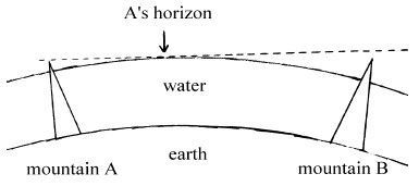
It might be thought that this idea, taken to its logical conclusion, leads immediately to the result that the ark must have landed on the highest mountain in the Ararat region. If it had landed on a shorter mountain, wouldn't the taller mountain already have been exposed above the surface of the Flood waters? In fact, because of the curvature of the surface of the spherical earth, it would have been possible for some mountains, which had already emerged from the Flood waters, to be hidden from Noah's view behind the horizon. (See Figure 2.) So Genesis 5:8 does not lead inevitably to the conclusion that the ark came to rest on the tallest mountain in the Ararat region. But the fact that it took 72 days for neighboring mountains to be exposed, during which time "the water decreased steadily", does suggest that the mountain the ark had landed on was the tallest one in its general vicinity.
 |
I applied this clue to the mountains of the Ararat region as follows.
I purchased five Tactical Pilotage Charts (TPCs) which together covered the area of interest to the present study.[14] These are topographical maps having a scale of 1:500,000. They are intended for aircraft pilots and are considerably more detailed and accurate than maps found in ordinary world atlases.
I must pause and give a word of caution before proceeding. Even though these maps are very good, they are not perfect. In the present study we would have liked the heights of all mountain peaks to be known to better than ±50 feet (3σ). But these maps do not provide such high precision. It is a general rule-of-thumb in science that a 1% uncertainty is fairly good for most physical measurements. Many of the mountains in the Ararat region are over 10,000 feet high. It was no surprise, therefore, to find noted on the TPC maps that the standard uncertainty in elevations marked with a • on the maps "does not exceed 100 feet" while those marked with an × can have an uncertainty two or even three times as large.
But even if these maps could give elevations accurate to the nearest foot, we would still face some uncertainty with the present study. The fact is that mountains do change with time, and 5,500 years (back to the Flood) is a long time. For example, a mountain that erodes as little as one inch per year will have lost over 450 feet in 5,500 years. Furthermore, many of the mountains in the Ararat region—including Mount Ararat—are volcanic. There is no guarantee that none of these mountains have gained or lost substantial height through volcanic activity since the Flood.
Obviously, we must either be (intelligently) prepared to put up with these uncertainties, or forgo the present investigation altogether. But there is no reason to be timid, in my opinion. While it is clear from the outset that the final results of the present search cannot be guaranteed certain, the fact is that the mountains of Ararat have been measured to reasonable precision and it is reasonable to believe the topography of these mountains today mirrors the landscape Noah looked out upon from the ark 5500 years ago to a very large extent.
Additionally it is possible to minimize the impact of these uncertainties by adopting a probabilistic approach to the problem which considers multiple factors together. I have adopted such an approach in the current study.
But most importantly, please note that I am not attempting to prove anything here. I am, first of all, not attempting to prove that the Bible is true when it says the ark landed upon the mountains of Ararat. My confidence rests in the testimony of Scripture which states that the ark landed upon some mountain in the Ararat region—that matter requires no further proof as far as I am concerned. I am also not attempting to prove that the ark landed upon any given mountain in Ararat. Rather, I am only attempting to determine as scientifically as possible which of the many hundreds of mountains in the Ararat region seems at the present time to best satisfy the requirements of the Biblical narrative. For this purpose the TPC maps seem adequate, even if not entirely ideal.
Many spot elevations are given on the TPC maps. These are predominantly notations of the highest points—of obvious concern to pilots. Most simply note the heights of the peaks of mountains. A few, in low-lying areas, appear to give the elevations of small hills. Because we expect the mountain the ark rested on to be the tallest in its vicinity we expect the height of that mountain to be included among the spot elevations on these maps.
The first step in my search procedure was to test every mountain for which a spot elevation was given on these maps in the region of interest to the present study to see if any other mountain would be visible from it when it was barely covered by water. Because of the large number of mountains involved I found it necessary to use a computer to carry out this test. This meant that the positions (longitude and latitude) and heights (i.e., spot elevations) of the mountains shown on these maps needed to be entered into the computer. To avoid any subjective bias I decided to enter every spot elevation given on the maps within the chosen area of study, even those few which obviously only corresponded to low hills. I entered a total of 1,441 spot elevations with their corresponding position coordinates from the region of study.
As mentioned above, I chose as the region of study the area bounded by longitudes 37°E on the west and 48°E on the east, and latitudes 36°N on the south and 42°N on the north. (See Figure 1.) The extent of the studied region was deliberately chosen to exceed the extent of the Ararat region because candidate mountains within the Ararat region must still be tested against neighbors in areas adjacent to the Ararat region.
I next had to program the computer with the search criteria. This criteria was made suitably quantitative as follows.
The question of whether a neighbor mountain B will be visible from candidate mountain A when A is barely covered by water divides into several cases. If the elevation of B is less than A, then B will still be covered by water and will not be seen from A. If the elevation of B is greater than A then B will be out of water. It will be visible from A if it is close enough to A. It will be hidden behind the horizon if it is too far from A.
A little math quickly reveals that the critical distance, r, at which B will be barely visible from A is given by the equation:

In this equation e is the difference in height of the two mountains, A and B, and R is the mean radius of the earth, for which I have used the value 6,371 km. This equation shows, for example, that if B is 1 km higher than A then it will be visible from A when A is barely covered by water if the distance between A and B is less than 113 km.
I wrote a simple computer program which uses this equation to test each mountain in the region of study against all other mountains in the region of study to see which mountains would have no visible neighbors when barely covered by water. Of the 1,441 peaks entered, only 41 survived this test.
But 41 candidates is still 40 more than we would like. To reduce the number of candidates further I evaluated each of these 41 candidates in six categories.
My strategy at this point is perhaps best explained by an analogy. Imagine the police are looking for a certain criminal. They have rounded up 41 bad guys and are reasonably confident the man they are looking for is one of these 41. Unfortunately, the description of the criminal they have to go on is rather abbreviated, and worse still, they have been tipped off that the criminal may have had his appearance altered since the crime. Nonetheless, they determine to do the best they can using six characteristics of the criminal which they have deduced from the scene of the crime: his height was about 5 feet 7 inches; his hair was brown; he seems to have been muscular; …
The police detective ranks each bad guy in each of these six categories. For example, in the height category, the bad guy whose height is closest to 5 feet 7 inches is given a rank of 1. The bad guy whose height is next closest gets a rank of 2, and so on.
Clearly, if bad guy X is found to rank first in all six categories while the ranks of the other bad guys show no consistent behavior in the six categories, then the detective should choose X—he is an excellent match to the description.
But the detective doesn't need to have such clear-cut evidence to make a good choice. He can use the ranking he has done to evaluate the probability a given bad guy is the man he is looking for.
To carry out this probability test the detective converts the rank numbers to probabilities by simply dividing the ranks by the number of bad guys. For example, bad guy Y ranks 37 in the height category with a height of 5 feet 1 inch. From this the detective determines that the probability of one of these 41 bad guys having a height within 6 inches (i.e., 5 feet 7 inches minus 5 feet 1 inch) of the expected height of 5 feet 7 inches is 37/41.
The detective evaluates the relative probability of a given bad guy being the man he is looking for by multiplying the six probabilities for that bad guy together, one from each category. By doing so he is evaluating the total probability of that bad guy looking as similar as he does to the description of the criminal. A relatively high probability of looking that similar means lots of bad guys look that similar and this is probably not the bad guy he is looking for. A relatively low probability, however, means it is unlikely for a bad guy to look that similar to the description of the criminal, and in that case the degree of similarity may be more than just a coincidence.
If the detective finds that bad guy X has a total probability (after multiplication of the six probabilities) which is very much lower than the probability for the other 40 bad guys then he has objective grounds for once again choosing X. X is then, by far, the most likely of the lot.
Note, however, that the detective will not be able to make a choice if two or more bad guys share nearly identical lowest probabilities. This would mean they were equally similar to the description. (Perhaps the criminal has a twin brother, also pursuing a career in crime!) If none of the bad guys has a probability much lower than any of the others the test fails altogether and the detective is back to the drawing board. This would perhaps suggest that the criminal did a truly remarkable job of altering his appearance before the test was conducted.
Now I will divulge the information that Mount Ararat is among the 41 candidates which we are about to examine by the procedure just described. But to protect the innocent (actually, to keep the discussion unprejudiced) I will forgo any further discussion of individual mountain identities until the completion of the examination. At this stage we are obviously interested in minimizing subjective bias and maximizing the degree of conformity of our test to the text of Scripture.
I first looked at the distance from each candidate to the heart of the Ararat region around Lake Van. Some of the candidates were out near the border of the region of study, in areas which almost certainly were never part of the Ararat region—to the west of Malatya, in the plains of Syria to the south, and to the east of Lake Urmia, for example. Because of their location outside the Ararat region these obviously have very little likelihood of being the true mountain the ark rested on.
To proceed quantitatively I defined the "heart" of the Ararat region at longitude 43°E and latitude 38.667°N. This, according to the TPC maps, falls in the middle of Lake Van, around which, according to the quotes above, the kingdom of Ararat was centered. I then wrote another computer program to determine the distance between this point and each candidate mountain. The candidates were then ranked. The candidate which was closest to the heart of Ararat was assigned a rank of 1, and the one furthest from the heart of Ararat was assigned a rank of 41.
I next computed a rank for each of the 41 candidates based on the height of the candidate relative to its first seen neighbor. The idea here is that Genesis records that 72 days elapsed between the grounding of the ark and the appearance of neighboring mountains. During these 72 days the "water decreased steadily". Meanwhile, in just 160 days from the time the ark came to rest the ground around the base of the mountain was observed by Noah to be dry. This would mean that the mountain the ark was on stood (160/(160-72)=) 1.8 times higher above its base than the height of the water when the first neighbor appeared if the water decreased at a constant rate. While it is unlikely the water decreased at a constant rate for this entire interval the indication still seems fairly strong that the mountain the ark came to rest upon was significantly taller than its neighbors.
I calculated the height of each of the 41 candidate mountains above its base and computed the ratio of this height to that of the height of the water above this same base when the first neighbor mountain was seen. I defined the base level as the height of the water at which roughly 90% of dry land today within a 50 mile radius of the candidate mountain would be above water back then. I obtained my estimate of this base level by visual inspection of the contours on the TPC maps around each candidate.
The candidate mountain having the highest ratio achieved the rank of 1; the candidate with the lowest ratio (equal, in fact, to 1) was ranked 41.
For the third category I compared the water heights when the first two neighboring mountains became visible from each candidate. Genesis 8:5 reports neighboring "mountains" (plural) as the first visible land. This means that at least two mountains became visible during an interval of 24 hours.
To measure the relative conformity of each candidate to this Biblical requirement I computed the difference between the height of the water when the first neighbor was seen and the height of the water when the second neighbor was seen. I then divided this by the difference between the height of the candidate mountain and the height of the water when the first neighbor was seen.
For a constant rate of decrease in water height this ratio should be less than 1/72—1 being the maximum number of days allowed to expose the second neighbor after the first has become exposed, and 72 the number of days it took to expose the first neighbor from the time the ark grounded. The closer this ratio is to zero the more likely it is that the two neighbors would have been seen at the same time.
The candidate having the lowest ratio was assigned rank 1 in this category.
In the fourth category I looked at the shape of the 41 candidate mountains. As noted above, Noah seems to have been unable to see the mountain the ark rested upon from inside the ark. This is presumably because his view much below the horizontal plain was restricted by the upper deck of the ark itself.
Such a restricted view is implied in several ways by the Flood narrative: the fact that Noah had to remove the covering of the ark to see that the ground was dry around the base of the mountain, and the fact that Noah had to send birds out from the ark to learn about his immediate environs, for example.
But we must couple this restricted view with the idea that the mountain the ark had landed on must have been somewhat conical and steeply sloped to fully explain Noah's actions and observations. Clearly, the narrower the top of the mountain we imagine the ark resting upon the more probable it becomes that Noah would have been unable to see it from inside the ark.
I calculated the ratio of the height of the candidate mountain exposed above water when the first neighbor became visible to the maximum width of the exposed portion of the mountain. The width was measured horizontally from the summit to the widest point on the exposed mountain. This widest point was estimated from the TPC maps. I used the closest contour to the height of the water wherever possible. With candidate mountains having a first-visible neighbor of nearly the same height, it was necessary to use the next lower contour to estimate the shape. In a few cases it was necessary to go down one or two contour increments (usually 500 or 1000 feet) on the mountain to reduce measurement error.
The candidate with the highest ratio of height to width received rank 1 in this category.
Genesis 8:4 says "the ark rested in the mountains of Ararat". For Category 5 I ranked the 41 candidates according to how "in the mountains" they could be said to be.
When looked at on the TPC maps the Ararat region is seen to be made up of some large lakes, a significant proportion of high plateau, a few sizable valleys, and extensive foothills in addition to some large mountainous areas. Mountains are conspicuous on the TPC maps because elevations above 9,000 feet are colored differently than lower elevations and many of the mountains of Ararat exceed this elevation.
To estimate how "in the mountains" a candidate was I had the computer count the number of spot elevations greater than 9,000 feet within a 50 mile radius of the candidate. The candidate with the greatest number of such tall neighbors was given the rank of 1.
I took my final clue from Genesis 11:2. It says of Noah's descendants, "And it came about as they journeyed east, that they found a plain in the land of Shinar and settled there" (NASB). This seems to imply that the discovery of Shinar by Noah's descendants was accidental rather than deliberate.
It seems probable that Noah's descendants would simply have followed the course of a river as they journeyed. This would ensure them adequate water while in the Ararat region, which receives only light seasonal rain today. As they moved further east and south it would have become increasingly mandatory to follow the river since it seldom rains at all in those regions.
The numerous mountain streams of the southern Ararat region generally find their way ultimately into the Tigris. It seems probable that Noah's descendants happened upon Shinar simply as a consequence of following some such stream to the Tigris and then following the Tigris to the east.
In any event, it seems reasonable to suppose that the closer the ark landed to the Tigris, and the further it landed down the Tigris toward Shinar, the more likely Noah's descendants would be of winding up in Shinar.
The Tigris leaves our designated area of study at longitude 43.33°E and 36.0°N. I had the computer rank the candidates according to their proximity to this point. The closest candidate was given the rank of 1.
Table 1 shows the ranking of each candidate in each category. The column on the far right shows the relative likelihood of the corresponding candidate being the mountain the ark landed on according to the six criteria outlined above.[15] These likelihoods are relative to Candidate 1 which is Mount Ararat.
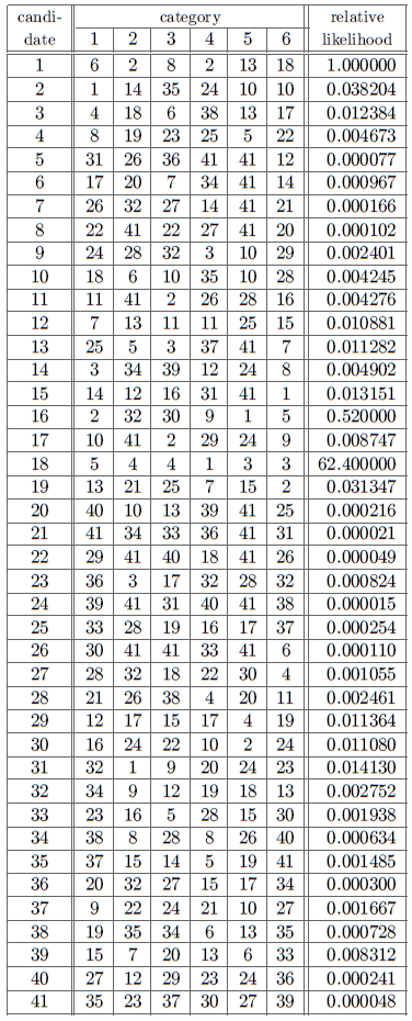 |
It is apparent from Table 1 that the traditional claim that Mount Ararat is the resting place of the ark is not supported. There is another candidate—Candidate 18—which is considerably more likely to be the mountain the ark rested upon than Mount Ararat. According to this study Candidate 18 is 62.4 times more likely than Mount Ararat to be the mountain which corresponds to the Biblical narrative.
Candidate 18 is labeled "Cilo Dagi" on the maps; I will call it Mount Cilo. Its position is shown in Figure 1.
Table 1 shows that Mount Ararat (Candidate 1) and Mount Cilo (Candidate 18) both have high ranks in the first four categories. They are about the same distance from the center of Lake Van. They are both quite tall relative to their neighbors. They both have two first-visible neighbors of comparable height. And they are both steeply sloped. Notice, however, that Mount Cilo ranks higher than Mount Ararat in three of these four categories.
Though Mount Cilo is already more likely than Mount Ararat to be the mountain the ark landed on when just these first four categories are considered, it is the final two categories which separate them most distinctly. Mount Ararat ranks thirteenth for being "in the mountains" while Mount Cilo ranks third. A glance at the TPC maps confirms that this relative ranking is correct. Mount Ararat isn't really "in the mountains". A broad valley, associated with the Aras River, runs all along its northeast side, for example. This valley obtains a width of some 50 miles immediately to the north of Mount Ararat. An extension of this valley wraps around the base of Mount Ararat and its sister, Lesser Ararat, all along the south.
Mount Ararat and its sister are really somewhat isolated from other mountains. Mount Ararat is a very impressive mountain in photographs for just this reason. It is an enormous mountain, and it sits pretty much out in the open, dominating the view from the extensive valleys and plains at its base. But also, for just this reason, it is not really appropriate to say "the ark rested in the mountains of Ararat" if the ark grounded at the summit of Mount Ararat. It seems that a more accurate description in that case would be "the ark rested upon a mountain in Ararat". The setting of Mount Ararat doesn't seem to match the Biblical description very well—which is why its rank is only 13 in this category.
By way of contrast Mount Cilo really is "in the mountains". It is in the middle of a very mountainous area, and many of the mountains which surround it are over 10,000 feet high. Its high rank of 3 clearly reflects the good match between Mount Cilo's setting and the Biblical description.
Mount Ararat is also located much further from the Tigris than Mount Cilo. If one follows any stream from the base of Mount Ararat they will come to the Aras River. If they follow the Aras River they will come eventually to the Caspian Sea. There is no obvious reason why one would come upon the land of Shinar starting from Mount Ararat.
In contrast once again, every stream which flows from the base of Mount Cilo leads ultimately to the Tigris and to the land of Shinar.
Does this mean that Mount Cilo was the mountain the ark rested upon? Probably. A factor of 62 in likelihood is difficult to explain otherwise. Why else should this previously unknown and unsung mountain match the Biblical narrative so much better than any of its 1,440 competitors?
If we bar Mount Cilo from the competition, then Mount Ararat becomes the winner. But notice that Mount Ararat is only about twice as likely as Candidate 16, the next most likely mountain. The slight difference between these two candidates contrasts sharply with the factor of 62 which separates Mount Cilo from Mount Ararat. The numbers say that Mount Cilo is an excellent match to the Biblical description and that no compelling alternate candidate exists.
If Mount Cilo is the mountain the ark rested upon, then it is immediately clear why the numerous expeditions to Mount Ararat have never turned up any evidence of the ark ever having been there. I am caused to wonder, of course, whether the ark might possibly be discovered one day on Mount Cilo?
But rather than speculate on such lofty questions, let me emphasize what is now perfectly clear. If we are to place the determination of the depth of the Flood on a scientifically defensible basis then we must reject the traditional Mount Ararat as the resting place for the ark and adopt Mount Cilo. I hope to explore the interesting consequences of this conclusion next issue. ◇
Dear Dr. Aardsma,
Galatians 3:17 states that the law was introduced 430 years after the promise to Abraham. Isaac was born around 3070 B.C. so the promise would have had to be given before then. Adding 430 years to this date yields 2640 B.C. But the law was given sometime after the Exodus in 2447 B.C., creating a discrepancy of at least 193 years. Please advise me on how this can be rectified.
T. Basil Finnegan
Broadway, VA
Dear Basil,
Your question is a good one. The "430 years" of Galatians 3:17 has caused much perplexity for many Bible scholars and students. I think the answer is fairly simple, in fact, though it renders Paul's argument in Galatians 3 more profound than is generally recognized.
Galatians 3:16 and 17 read (NASB):
Now the promises were spoken to Abraham and to his seed. He does not say, "And to seeds," as referring to many, but rather to one, "And to your seed," that is, Christ. What I am saying is this: the Law, which came four hundred and thirty years later, does not invalidate a covenant previously ratified by God, so as to nullify the promise.
The one clearly known point in Paul's reference to the 430 years in these verses is the giving of the Law at the end of it. This we know happened at Sinai shortly after the Israelites left Egypt.
Using Old Testament chronology as a guide, next work backward from this known point. What happened 430 years before the Israelites left Egypt? Exodus 12:40 & 41 are very clear about this:
Now the time that the sons of Israel lived in Egypt was four hundred and thirty years. And it came about at the end of four hundred and thirty years, to the very day, that all the hosts of the Lord went out from the land of Egypt."This "430 years" matches exactly with Paul's "430 years" in Galatians 3:17 and it seems appropriate, if not mandatory, to identify them as one and the same.
This impacts the interpretation of Galatians 3:17. Paul says: "the law which came four hundred and thirty years later", but he doesn't specify what it came later than. It is natural, in the context, if one ignores Old Testament chronology, to assume he means later than the giving of the promises to Abraham. So the verse is usually understood as follows: "the Law, which came 430 years later than the giving of the promises to Abraham, does not invalidate a covenant which was ratified previous to the giving of the Law following the Exodus". But chronological considerations hinder this interpretation and imply that Paul really means "the Law, which came 430 years later than the entrance of Jacob and his family into Egypt, does not invalidate a covenant which was ratified previous to the entrance of Jacob and his family into Egypt".
Why would Paul choose the entrance of Jacob and his family into Egypt as his time reference in verse 17? After all, one might argue, this event is in between the two points in time the passage seems to be dealing with: the giving of the promises to Abraham and the giving of the Law to Moses. Isn't it superfluous and somewhat unnatural to interject the entrance into Egypt at this point in the argument?
I suggest that this interjection is, in fact, highly germane to Paul's overall argument. By it Paul emphasizes that the Law is not primary. Rather, it is God's promises to Abraham which are primary. Subsequent history, including the giving of the Law, is merely a consequence of these promises. I suggest that Paul is here using chronology to invoke the historical image of the entrance of Jacob and his family into Egypt to reinforce and illustrate the fact that the Law is not primary. It is clear to anyone familiar with the Old Testament that the entrance into Egypt was nothing more than an inevitable consequence of God's promises to Abraham. So also the Law. And that which is itself an inevitable consequence of some other event cannot itself be regarded as primary.
Let me attempt to explain in a little more detail.
In the broader context of this passage Paul is arguing that Christ Jesus is the seed promised to Abraham, the One who caused all nations to be blessed in Abraham. The major point of Paul's argument is that the inheritance of the blessing is based on God's promises to Abraham, not on adherence to the Law.
In verse 16 Paul refers to "promises" (plural) given to Abraham. What are these promises? They are: 1. I will make you a great nation (Genesis 12:2); 2. I will bless you (Genesis 12:2); 3. I will make your name great (Genesis 12:2); 4. I will bless those who bless you (Genesis 12:3); 5. I will curse those who curse you (Genesis 12:3); 6. All the families of the earth shall be blessed in you (Genesis 12:3; 22:18); 7. You will have a son (Genesis 15:4; 17:16,19); 8. Your descendants shall be innumerable (Genesis 15:5; 22:17); 9. Canaan will be given to your descendants (Genesis 15:7,18–21; 17:8); 10. Your descendants will be strangers in a foreign land and enslaved 400 years (Genesis 15:13); 11. They will come out of that land with many possessions (Genesis 15:14); 12. You will live to an old age (Genesis 15:15); 13. Your descendants will return to Canaan (Genesis 15:16); 14. You will be father to a multitude of nations (Genesis 17:4,5); 15. I will be your God and the God of your descendants forever (Genesis 17:7); 16. Your descendants will be victorious over their enemies (Genesis 22:17).
I suggest that Paul is using the entrance of Israel into Egypt as his time reference in Galatians 3:17 specifically because, like the more conspicuous Exodus event which took place 430 years later and the giving of the Law which accompanied that event, it was a part of the carrying out of these sixteen promises which God had made to Abraham. It is clear that the entrance into Egypt was not a beginning of something new. Rather, it was a partial fulfilling of something more ancient and more profound. Similarly, the Exodus and giving of the Law were not a beginning of something new. These, too, was merely a partial fulfilling of the more ancient and more fundamental promises which God had made to Abraham long before.
The thrust of the argument is that the Law was given as just another historical item in the flow of the working out of God's promises to Abraham—the Law is in the stream of history which flows from God's promises to Abraham. The Law is not a separate entity unto itself, somehow independent of and superseding the promises. The promises are the fundamental thing—the fountain from which the succeeding stream of history flows. It is the promises which are the essential purpose and focus of God, not the Law. The Law was given to serve in carrying out the promises. It was never intended as an end in itself.
I suggest that Paul assumed his readers were sufficiently familiar with Old Testament history and chronology to get his point without his having to spell it all out. The correspondence between his "430 years" and that of Exodus 12:40–41 is a pretty strong hint, after all. In any event he does not pause to explain as, in the middle of his argument he deliberately moves his time reference along in the flow of history which rises from the giving of the promises to Abraham. But by so moving his time reference he skillfully accentuates his point that the whole flow of history from Abraham on down—including the giving of the Law—is focused on the fulfillment of God's promises to Abraham, ultimately culminating in the eternal inheritance and blessing which those who place their faith in the promised Seed, Christ Jesus, receive.
Gerald E. Aardsma, Ph.D.
Loda, IL
The Biblical Chronologist is a bimonthly subscription newsletter about Biblical chronology. It is written and edited by Gerald E. Aardsma, a Ph.D. scientist (nuclear physics) with special background in radioisotopic dating methods such as radiocarbon. The Biblical Chronologist has a threefold purpose: to encourage, enrich, and strengthen the faith of conservative Christians through instruction in Biblical chronology, to foster informed, up-to-date, scholarly research in this vital field within the conservative Christian community, and to communicate current developments and discoveries in Biblical chronology in an easily understood manner. An introductory packet containing three sample issues and a subscription order form is available for $9.95 US regardless of destination address. Send check or money order in US funds and request the "Intro Pack." The Biblical Chronologist (ISSN 1081-762X) is published six times a year by Aardsma Research & Publishing, 412 N Mulberry, Loda, IL 60948-9651. Copyright © 1997 by Aardsma Research & Publishing. Photocopying or reproduction strictly prohibited without written permission from the publisher.
|
^ Gerald E. Aardsma, A New Approach to the Chronology of Biblical History from Abraham to Samuel, 2nd ed. (Loda IL: Aardsma Research and Publishing, 1993).
^ Gerald E. Aardsma, "Research in Progress," The Biblical Chronologist 1.1 (January/February 1995): 6–7. Gerald E. Aardsma, "Research in Progress," The Biblical Chronologist 1.2 (March/April 1995): 6–8. Gerald E. Aardsma, "Research in Progress," The Biblical Chronologist 1.4 (July/August 1995): 6–10.
^ Genesis 9:6.
^ Genesis 7:19–20.
^ Gerald E. Aardsma, "Chronology of Noah's Flood," The Biblical Chronologist 3.1 (January/February 1997): 1–8.
^ Gerald E. Aardsma, "Noah's Flood at Elk Lake," The Biblical Chronologist 2.6 (November/December 1996): 1–13.
^ Gerald E. Aardsma, "Yeroham—The True Mt. Sinai?" The Biblical Chronologist 1.6 (November/December 1995): 1–8. Gerald E. Aardsma, "Biblical Chronology 101," The Biblical Chronologist 2.2 (March/April 1996): 9–12.
^ For a refutation of one such claim see: R. E. Taylor and Rainer Berger, "The Date of 'Noah's Ark'," Antiquity LIV (1980): 34–36.
^ For example: W. W. Gasque, "Ararat," The International Standard Bible Encyclopedia, ed. Geoffrey W. Bromiley (Grand Rapids: Eerdmans, 1979), 233.
^ W. W. Gasque, "Ararat," The International Standard Bible Encyclopedia, ed. Geoffrey W. Bromiley (Grand Rapids: Eerdmans, 1979), 233.
^ H. A. Hoffner, Jr., "Ararat," The Zondervan Pictorial Encyclopedia of the Bible, vol. 1, ed. Merrill C. Tenney (Grand Rapids: Zondervan, 1976), 255.
^ "Ararat, Mount," The New Encyclopaedia Britannica, vol. 1 (Chicago: Encyclopaedia Britannica, 1997), 518.
^ Georges Dumezil, "Armenia," The Encyclopedia Americana (Chicago: Rand McNally, 1962), 266.
^ The five maps I worked from were F-4C, F-4D, G-4A, G-4B, and G-5A. These were all prepared and published by the Defense Mapping Agency Aerospace Center, St. Louis, Missouri. They can be ordered from: NOAA Distribution Branch (N/CG33), National Ocean Service, Riverdale, MD 20737-1199. I obtained my copies through Map World, 123-D North El Camino Real, Encinitas, CA 92024, (800)246-6277.
^ The relative likelihood was computed as follows. First the ranks were converted to probabilities by dividing each by the total number of candidates. The six probabilities for each candidate were then multiplied to obtain the combined probability of that candidate looking as similar to the Biblical description of the resting place of the ark as it does. These combined probabilities were then inverted and multiplied by the combined probability of Mount Ararat (Candidate 1) to obtain the relative likelihood.