
| |
| Volume 5, Number 6 | November/December 1999 |
I introduced Céide (pronounced kay'jeh) Fields three issues ago.[1] I explained that Céide Fields consists of some 4,500 acres of Neolithic agricultural fields enclosed by miles of stone walls, all found buried as much as twelve feet deep beneath blanket bog-peat in North Mayo, Ireland, today. In addition to the walls, massive tombs, constructed of large slabs of uncut rock, are found in association with the agricultural fields, as are also typical Neolithic stone tools.
I showed, using radiocarbon dates from pine stumps found buried in position of growth within the peat overlying the fields, that human occupation of Céide Fields terminated coincident with the date of Noah's Flood which modern Biblical chronology calculates, i.e., 3520±21 B.C.[2] This same phenomenon, i.e., an abrupt termination of a culture within secular dating uncertainties of the Flood, has also been shown previously for the Chalcolithic civilization of Palestine.[3] While one group of secular archaeologists wonders at the apparent "abandonment" of Céide Fields, and another group wonders at the apparent "abandonment" of Chalcolithic sites in Palestine, Biblical chronology unifies both sets of data under a single historical event—Noah's Flood.
Once it is understood that civilization at Céide Fields was terminated by the Flood, the remarkable nature of Céide Fields becomes clear. Céide Fields preserves a pre-Flood agricultural landscape. In terms of stratigraphy, the interface between the mineral soil and the overlying peat at Céide Fields corresponds precisely to the coming of the Flood itself.
Two issues ago I introduced pollen data in concert with radiocarbon dates from a peat core taken at Céide Fields. I used these data to date the arrival of the first pre-Flood settlers to Céide Fields. The pollen chronology data reveal the initial clearing of the forests and establishing of agricultural fields in the area beginning 4000±100 B.C. They also strongly reinforce the termination of this agricultural community synchronous with the Flood some 500 years following the initial settlement.[4]
Last issue I used the peat data once again to show that the post-Flood resettlement of Céide Fields took place 2500±100 B.C.—a full millennium after the Flood.[5]
This issue I focus attention on the stone walls found bordering the agricultural fields at Céide Fields. They have their own interesting story to tell.
The data for this study are provided once again by Molloy and O'Connell.[6] These data are summarized in the schematic diagram due to Molloy and O'Connell shown in Figure 1. The data consist of a single cross-section of one stone wall at Céide Fields with its overlying peat and underlying soil stratigraphy.
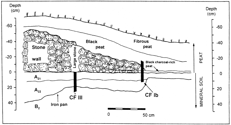 |
It is immediately obvious from the diagram that the wall which Molloy and O'Connell studied had collapsed. The "large stone" in the diagram seems to represent the edge of the original wall.
In all cases the walls are built of stone, with the larger stones usually set upright and smaller stones laid in between.[7]The diagram only shows one side of the wall; in actual fact the lateral spread of stones was found to extend to both sides of the wall. This is the normal state of the walls today.
In a typical cross-sectional view, the walls seldom exceed 80 cm in height, are typically 50-70 cm tall, and, furthermore, slope gently to either side to give a lateral spread of stones of c. 2.5 m.[8]This description suggests that the walls stood roughly three feet tall originally, but that they have been reduced by subsequent collapse to as little as half this height.
In addition to the fact that the walls are found in this collapsed state at present, one other piece of data is of interest to the present study. This is the "black charcoal-rich peat" layer shown immediately above the mineral soil in the diagram. Molloy and O'Connell supply two additional pieces of information in relation to this layer:
A distinct black, charcoal-rich layer of peat, 2.5 cm thick, covered the mineral ground and was present also between the stones of the lateral spread but peat was not observed beneath the stones.[9]And from their Table 6 list of stratigraphic details:
Black charcoal-rich peat, 2.5 cm thick, forms a distinct layer overlying the mineral ground. It is interrupted by the stones constituting the central part of the wall where profile CF III was taken.[10]
What do these data mean? How are they to be explained?
Notice, first of all, that the stratigraphy dictates a distinct sequence of events. It shows us that: first the walls were built, then they collapsed, and then a layer of charcoal-rich peat was laid down. If the layer of charcoal-rich peat had been formed before the walls were built, remnants of it would be found beneath the stones of the core of the wall. But the charcoal-rich layer does not extend beneath the core of the wall. If the layer of charcoal-rich peat had formed before the wall collapsed, remnants of it would be found beneath the fallen stones of the lateral spread. But it is only found around the stones of the lateral spread, not beneath them. Since the charcoal-rich peat is not found beneath the stones either of the core of the wall or of the collapsed, lateral spread, the charcoal-rich layer must have formed only after the wall collapsed.
Though the sequence of events is clear, the quantitative chronology (i.e., the dates when these things happened) can only be conjectured at this stage. So far we lack reliable chronological data (i.e., radiocarbon dates) for when the wall was built, when it collapsed, and when the layer of charcoal-rich peat was formed.
I do not mean to suggest that we are totally clueless about the chronology. We know that the wall must have been built sometime between 4000±100 B.C. (when the first settlers arrived in the area) and 3520±21 B.C (when the Flood came and swept everybody away). We can reasonably infer that the walls must have collapsed when nobody was left to repair them—i.e., coincident with or following the Flood. Otherwise, we may suppose, they would have been repaired. And we can reasonably infer that the charcoal-rich peat layer must have been formed fairly soon after the walls collapsed. Otherwise the spaces between the fallen stones would have become sealed off by dust, dirt, and plant debris, prohibiting penetration of the charcoal-rich layer in around the fallen stones.
Thus we can gain some sense of time constraints, but chronological data specifying when exactly these things happened are so far lacking.
In the absence of definitive chronological data we can only build plausible scenarios. Ordinarily I try to stay clear of these. As I have previously shown, one can tell a lot of stories from just a few facts in the absence of chronological constraints.[11] But I have two reasons for making an exception in this instance. First, the scenario I will set forth is easily shown to be wrong if it is wrong. This can be accomplished by radiocarbon dating the charcoal (not the peat) from the charcoal-rich peat layer. Why this is the case will become clear below.
Second, it is not necessary to use excessive imagination to arrive at the scenario I will postulate. It is, in fact, just a simple extension of what we already have come to understand about the cause of the Flood.[12]
I have previously advanced the hypothesis that the root physical cause of the Flood was collision of a very high speed cosmic projectile with Earth.[13] How this naturally unfolded to produce the Flood in the hours, weeks, and months following the impact is detailed elsewhere.[14] For the present discussion it is the prompt effects of the impact which are of interest—those which took place seconds and minutes after the collision, rather than those which took place on the scale of hours and days.
A great deal of effort has been expended by scientists in recent decades to model collisions of rocks from space with Earth.[15] This research is motivated in part by the threat which asteroid impacts pose to civilization, and in part by the similarities between asteroid impacts and nuclear explosions. All of this effort is of great benefit in the present context.
When a chunk of rock from space, measuring on the order of tens of miles, strikes the surface of the earth, one can imagine that quite a violent collision results. The rock has a very high speed relative to the surface of the earth prior to the impact, and this gives it an enormous kinetic energy. When the rock strikes the surface of the earth this energy is released in a relatively short distance. The result is similar to what one might expect if literally multiple millions of tons of TNT were set off beneath the surface of the ground. An enormous explosion results. Though the projectile and target are made of solid rock, the energy of the collision is such that the projectile and a portion of the target are more or less instantaneously vaporized. This vaporized matter expands at high velocity from the impact site in the form of a super-hot cloud. Shock waves radiate from the impact site. Fragments of rock of all sizes, from microscopic to boulder, fly from the impact crater in all directions at extremely high velocities. Seismic waves comparable to those responsible for the largest earthquakes are produced, radiating outward from the impact site.
I have previously pointed out, through quantitative analysis, that the energy of the Flood projectile was way beyond what one might expect from an asteroid.[16] (Recall that asteroids are chunks of rock, bound, like the planets, by gravitation to the sun.) Scientists talk in terms of 10^8 or 10^9 megatons TNT equivalent yield for the biggest and most globally destructive asteroid impacts. (10^9 megatons is a billion megatons, or a billion times a million tons of TNT.) I have calculated the energy of the Flood projectile to be at least 2×10¹⁵ megatons. This is at least two million times more energetic than the biggest (i.e., 10^9 megaton) asteroid impacts. Thus, it appears that the Flood projectile came from beyond the solar system and was truly a cosmic projectile.
Though the Flood projectile was so much more energetic even than the largest asteroid impacts, the basic kinds of phenomena associated with asteroid impacts would still be expected of the Flood impact. The collapsed walls of Céide Fields, and the one inch thick charcoal-rich layer lying upon the mineral soil, both find ready explanation within the scope of such phenomena.
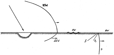
Figure 2 shows the sorts of highly energetic and destructive waves which radiate from an impact site.[17] The air blast shock wave (sometimes appropriately called a "fireball") is extremely destructive of buildings and life in the vicinity of the impact.
 |
Now I must break with the thread of the discussion here for a moment. I would very much like to be able to bring some numbers into the discussion at this point—for example, to quantify how far from the impact site the air blast would have been felt in the case of the Flood projectile—but I am unable to calculate meaningful numbers for many such questions at present.
You will appreciate, I trust, that impacts of even the asteroid type can not be studied in the science laboratory. Nuclear weapons testing has provided opportunity to study explosions at the low end of the asteroid impact range. But even these studies have been relatively few. In consequence there is a very serious lack of experimental data on asteroid impacts in general. This means that there is much quantitative uncertainty attached to even large asteroid impacts. Scientists are forced to use rough and uncertain extrapolations in attempting to quantify even these.
The Flood impact, being at least two million times more energetic than even the largest asteroid impacts, as I have mentioned above, is way beyond the range where extrapolation of results from nuclear weapons tests can be expected to yield meaningful quantitative results. We are necessarily restricted to a qualitative discussion for many aspects of the Flood impact.
I have already pointed out that the Flood impact had qualitative features unfamiliar to the literature on asteroid impacts. That is, the Flood projectile obviously penetrated deeply into the earth, relative to asteroid collisions, and this resulted in a super-heated back flow (a jet) of material from the excavated shaft back into space. This jet was probably sustained for multiple minutes or more.[18] We are able to deduce these qualitative features by application of fundamental physical laws to what we know about the nature of the Flood, especially what we learn of it from Genesis. All of this makes it quite clear at the outset that brute extrapolation of the literature on asteroid impacts will not successfully predict even all of the qualitative features of the Flood impact. Quantitatively meaningful extrapolation is clearly out of the question.
So I am unable to answer the question of whether the air blast from the Flood impact might have been felt at Céide Fields. Let us leave that question aside for the time being.
What I can say, with a considerable degree of confidence, is that the seismic waves from the Flood impact would have been felt at Céide Fields. It is these seismic waves, I suggest, which caused the collapse of the stone walls of Céide Fields.
Let us compare the seismic effect of an asteroid impact with the most destructive, catastrophic earthquakes. For an estimate of this effect we use the magnitude M in the Gutenberg-Richter scale… For [an impact energy of 10^5 megatons] we obtain M=9…For the earthquake in China in 1920 which had a magnitude M=8.5, more than 100,000 people were killed and the radius of the zone of devastation was as large as 600 km… For the kinetic energy of 10^5 to 10^6 Mt the area of devastation with M=9 increases to 1000 km [over 600 miles].[19]
Obviously, the Flood impact, with its energy no mere 10^5 or 10^6 but rather 1015 megatons(!)—that is, ten billion times greater than needed to yield effects similar to a magnitude 9 earthquake—must have produced quite a jolt in the northern regions surrounding the impact site. This jolt would not have been felt everywhere over the globe, of course. The energy in seismic waves falls off as one moves away from the impact site. But the scale of the Flood impact suggests that the radius of its "zone of devastation" due to its seismic waves may have extended out in excess of a thousand miles.
The amplitude and frequency spectrum of these seismic waves, by the time they had traversed the actual distance from the impact site to Céide Fields, is impossible to predict. And this makes it impossible to predict what degree of destruction they would have inflicted at Céide Fields. Indeed, it seems more reasonable at this point to reverse the procedure. We know that civilization at Céide Fields was terminated by the Flood. We know the Flood was initiated by a cosmic projectile impact of enormous energy somewhere off the northwest coast of Europe/Asia.[20] We know such an impact would induce a colossal "earthquake" for a very large distance surrounding it. Céide Fields, on the northwest coast of Europe, cannot be too far from the impact site. In light of all this it seems simplest to observe that whatever magnitude earthquake is needed to reduce stone walls to the rubble piles they are found to be at Céide Fields is what was felt at Céide Fields. I have no numbers on this, but having experienced a few earthquakes while living in California for a number of years, I know that much more than a small earth tremor will be needed to do the job.
But let us turn our attention to the charcoal-rich peat layer which Molloy and O'Connell found an inch thick on the ground near the wall and in around the fallen stones. This too is an expected consequence of a cosmic projectile impact.
The technical literature on asteroid impacts shows that one of their consequences is "wildfires". For a very large impact, the "fireball" which rises immediately after impact from the impact crater generates enough light energy to ignite fires over very large distances:
Radiation impulse on the Earth's surface obtained from numerical simulations was so great, that the energy absorbed by unit surface exceeds [the threshold of fire ignition] all over the area of direct vision… Thus, as a result of the radiation flux from the plasma plume [fireball] after a high-speed impact, fires can arise on [an area] with characteristic dimensions of 1000 km.[21]Radiant energy from the fireball is not the only potential source of wildfires. O. B. Toon et al. state, for example, that:
for large impacts the debris from the crater explodes into space and re-enters the atmosphere over much of the globe. This re-entering material reaches a high temperature, and its downward thermal radiation can ignite fires over most of the Earth.[22]
We may safely picture the forests and fields of the high north, at least, as ablaze minutes after the Flood projectile struck. And the one inch thick charcoal-rich peat layer covering the mineral soil at Céide Fields suggests that we may safely picture its agricultural fields and surrounding landscape ablaze as well.
At the surface of the earth P type seismic waves (see Figure 2) travel about 8 km/sec, and S waves somewhat less than 5 km/sec.[23] Rayleigh waves travel about nine tenths as fast as S waves, roughly 4 km/sec.[24] Thus, P waves will arrive a distance of 1000 km from the impact site about 2 minutes after the impact. Rayleigh waves will arrive about 4 minutes after impact. Even if the distance between the impact site and Céide Fields was several times 1000 km (I discuss the probable distance between Céide Fields and the impact site below), one would certainly expect the walls to have been knocked down before any significant amount of charcoal had been produced by wildfires.
One final question remaining is how the charcoal managed to get in around the fallen stones after they were down. This involves horizontal transport, over roughly a meter, through randomly placed stones (Figure 1). I suggest that the charcoal was transported around the fallen stones by water.
A further expectation of large asteroid impacts to ocean basins (as I have previously argued must be the case with the Flood impact)[25] is that they will loft enormous quantities of water into the atmosphere, from whence it will fall, for a prolonged period, as wet precipitation.
Even for modest impacts with energies above 102 megatons the water cloud will rise beyond 100 km, where it will form a great steam cloud. Portions of the cloud will be cold enough to form ice crystals which will fall downward and evaporate to humidify the lower atmosphere. However, the latent heat of water is significant so condensation will drive the cloud to adiabatically expand. Condensation after a 10^4 megaton impact may occur over several days, during which time the water will have been transported over great distances from the impact site.[26]Ocean water vaporized by the cosmic projectile impact is, as I have previously suggested, the likely source of the rain which the Genesis account of the Flood describes as an opening of the "floodgates of the sky". This impact-induced rain seems from the account to have persisted forty days and nights.[27]
Putting this all together leads to the following picture.
Within seconds after the Flood impact, a sustained firejet existed over the impact site. Within a matter of minutes the intense radiant energy from the super-heated matter in this jet had ignited wooden structures and withered and ignited plant life in and around Céide Fields. Also within minutes of the impact, powerful seismic waves arrived at Céide Fields, jolting the ground violently and throwing the stone walls down everywhere.
For many minutes after the walls were down the Céide Fields' countryside burned. Soon ash and charcoal were nearly all that remained of the previously verdant landscape, its cattle, and its human occupants. But then a torrential rain began, sourced from the vast quantities of water which had been elevated into the high atmosphere by the impact. This rapidly saturated the soil, puddled in low spots, and then overflowed these and began to flood the ground everywhere. Charcoal-rich organic debris from the surface was transported by the water to the walls. The interruption in the flow of the water occasioned by these stone wall "dams", and the open structure of the freshly fallen stones, served as a natural trap of these light, organic sediments.
In one sense we are done—we have looked at the probable implications of the stratigraphical data obtained by Molloy and O'Connell from one section of wall at Céide Fields. But I would like to take the discussion one step further before closing. As I have studied this data and its probable implications I have come to feel that the impact site might be located much closer to Ireland than the Kara Sea, the potential impact site I have previously suggested (Figure 3).[28]
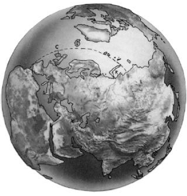 |
The choice of the Kara Sea has always been tentative, and I have tried to be careful to word it that way when I have discussed it in the past. This tentative assignment rests only on the Kara Sea being located in the calculated probable zone (a roughly 500 mile-wide strip of ocean stretching along northern Europe and northwest Asia—see Figure 3) and it having a shape suggestive of an impact crater. I am caused by the data at Céide Fields to tentatively advance an alternative location for the impact center, significantly closer to Céide Fields, Ireland, than the Kara Sea. This second candidate is Iceland.
Modest-sized asteroid impacts excavate a crater which is shaped like a dish or bowl. The most conspicuous features of such craters are the sunken dish itself and the circular rim of raised material around the outer perimeter of the dish. But as one moves to higher energy impacts crater morphology begins to change. In particular, craters with a central peak begin to appear. If you have ever observed a drop of water falling into a pail of still water, you will understand how this comes about. A "rebound" peak rises from the surface of the water soon after impact of the drop. This same basic hydrodynamic flow phenomenon can occur with the rock of the earth's crust with large enough impacts. If the energy range is right, the "rebound" peak can "freeze" before it has a chance to collapse to the crater floor. In that case, a crater with a central peak is formed.
I point this out to illustrate that dish-shaped craters are not the only possibility for high energy asteroid impacts. Central peaks and even concentric ring structures are also well documented, for example.[29]
As I have pointed out above, it is inappropriate to restrict the Flood impact to what one might expect of asteroid impacts. The two differ enormously in energy. So it is inappropriate to limit the morphology of the "crater" produced by the Flood projectile to the sorts of morphologies one is familiar with from the much lower-energy asteroid impacts. With the Flood projectile, we are in an unknown, unstudied regime.
Nonetheless, the general geomorphology of Iceland is suggestive.
Mountains rim the island like a jagged crown… The central plateau is a windswept desert of sand and lava.[30]
Iceland's candidacy rests on three additional factors.
First, it, too, is appropriately located. I have previously calculated that the impact site should not be much further away from Mt. Cilo, the probable landing place of the ark,[31] than 40°.[32] The dashed line in Figure 3 shows this approximate distance from Mt. Cilo. The physical structure of the interior of the earth and the necessary depth of the water of the Flood at Mt. Cilo impose this approximate limit. Iceland is only another 10% beyond this calculated distance, which is acceptable given the approximations involved in the calculation.
Iceland is located out in the deep ocean. If Iceland is the impact center then, presumably, there was no Iceland before the impact. Before the impact there was only deep ocean where Iceland now sits. Iceland was formed by the flow of lava from deep within the earth generated by the projectile impact.
Second, the distance from the center of Iceland to Céide Fields is only about 750 miles (1200 km), compared to 2400 miles (3900 km) from the center of the Kara Sea to Céide Fields. 750 miles seems more in the range expected for the evidence of seismic effects and wildfires from Céide Fields discussed above.
Third, it seems reasonable that the Flood impact site should still be geologically active today, and Iceland is currently one of the most volcanically active spots on the surface of the earth.
Heat travels relatively slowly inside the earth. To get a feel for this, notice that annual changes in temperature at the surface of the earth are reflected in temperature variations within the earth having a wavelength of about 20 meters.[33] Said another way, annual variations in temperature at the surface of the earth take one year to travel 20 meters into the earth.
I have previously suggested the Flood projectile may have had a diameter of 50 kilometers. We can reasonably expect it to have penetrated at least several diameters into the earth. When the impact was "all over" we can expect that an excess of energy (i.e., heat) remained trapped all along the length of its track into the earth. At a heat flow rate of 20 meters per year, excess heat from just two projectile diameters deep would only now be arriving at the surface. The fact that excess heat is currently venting in Iceland is abundantly clear:
More than a hundred volcanoes, some still active, make Iceland one of the most volcanic regions of the world… The volcanic rocks heat countless hot springs and geysers… The warm waters are piped to heat buildings and hothouses, in which vegetables, fruits, and flowers grow the year around. In some places water is piped through the soil to warm it for growing green crops.[34]
Iceland sits on a continuation of the Mid-Atlantic Ridge into northern latitudes. The ridge is known as Reykjanes Ridge to the south of Iceland, and Kolbeinsey Ridge to the north. This line of deep ocean ridges marks the boundary between adjoining slabs of rocky crust. The slabs, or plates, are like the pieces of the shell of an egg which has been cracked. The plates of the earth grind and push on each other at these boundaries, making the boundaries generally more active than the rest of the surface of the earth in regard to earthquakes and volcanoes.
I think it is common to explain Iceland's very high volcanic activity as due to its location on this boundary between plates. This is not altogether satisfactory, however. There are many plate boundaries girdling the earth, but Iceland appears to be uniquely "hot" and active. Something more than just the junction of plate boundaries seems to be needed to explain Iceland's unusually high density of volcanoes and other signs that it is presently venting excess heat from deep within the earth.
Interestingly, the idea that Iceland may be the impact center casts an entirely different light on its location on a boundary between plates. If one jabs a pin into a hardboiled egg, a jab where the shell is already cracked will obviously result in deepest penetration of the pin for equivalent energy input. If Iceland is the impact center then we must conclude that the Flood projectile, against all odds, struck the earth at a junction of plates, where the strength of the target was least.
This raises a whole new slate of possibilities regarding the depth of penetration of the projectile, the production of a super-heated gas jet back up out of the punctured shaft, the size and shape of the final crater, and much else besides.
If Iceland is the impact site, then it seems clear that we must begin to think of the Flood impact as unique in more ways than just its enormous energy. One is caused to wonder whether the result might have been quite different had the Flood projectile impacted on a plate rather than at a boundary between plates. The technical literature is full of predictions of mass extinction of life following collision of a large (10^9 Mt) asteroid with earth. These are not alarmist speculations; they are the sober implications of the scientific data and physical laws which bear on very high energy explosions. These implications arise because enormous amounts of energy are normally released at the surface of the earth when an asteroid collides with a continental land mass or with an ocean. This excess energy shows up in the environment in numerous disastrous ways, causing major disturbances to Earth's intricately designed life-support systems. For example, enough dust can be produced in the impact explosion and lofted into the atmosphere to block out the sun for a year or more, stopping photosynthesis and inducing mass starvation throughout Earth's animal kingdom.
But the Flood projectile is almost unthinkably more energetic than even the largest asteroid impact. The amazing wonder is that the earth is a habitable place at all even today, five and a half thousand years following that impact. Yet we know that Noah and his family left the ark and entered a world replete with sunshine (witness the rainbow) a mere year following the impact. The earth seems to have gotten off very lightly, really, compared to what might have been.
Is this possibly because the Flood projectile "just happened" to strike where the crust of the earth would naturally be weakest? This would minimize energy deposition at the surface of the earth—it would allow the projectile to penetrate deeply with minimal resistance and energy loss at the surface, expending the bulk of its energy at depth, rather than at the earth's surface. And this, in turn, would allow the energy to be shot quickly away from the earth in the form of a jet of vaporized matter, rather than lingering at earth's surface to pollute the environment and perturb Earth's life-support systems irrecoverably. Is this how we ended up with a clean and tidy Flood, rather than something a million times worse than a nuclear holocaust, which one might naturally expect of such an energetic impact? Are we possibly discerning the counsel of the Almighty in this choice of impact site?
The data from Céide Fields seem clearly supportive of the claim that the root physical cause of Noah's Flood was a cosmic projectile impact. They help us understand what the opening moments of Noah's Flood were like in a thousand mile radius around the impact site. They aid us in our efforts to pinpoint the impact site. They bring us face-to-face with what God's judgment means.
They also open new questions, generating new research topics and new research projects.
For example: is the interpretation of Molloy's and O'Connell's stratigraphic data which I have given above correct? It is easy enough to check. It predicts that the charcoal from the charcoal-rich layer found around the fallen stones of the wall will date to 3520±21 B.C., the Biblical date of the Flood. This can be checked by radiocarbon dating the charcoal.
Is Iceland the impact center? Here again chronology is the key to a definitive answer. But the chronology is not quite so easily discerned in this case. It involves dating rocks, rather than organic remains, and for this purpose radiocarbon cannot be used. And not only must we date rocks, but, according to the thesis, very young rocks at that. This is not easy—there will be pitfalls, such as inherited age and pseudo-isochrones, to deal with. This is a much bigger project. But it is one which needs to be pursued to a definitive conclusion just the same.
And one wonders what further answers the walls of Céide Fields may yet have to offer us. Is there possibly directional information to be gleaned from them? That is, might the direction to the epicenter of the seismic waves which knocked them down be determined from the distribution of the fallen stones? Note that Iceland and the Kara Sea are in very different directions from Céide Fields. They differ, in fact, by about 50° on the compass. If the collapsed walls do contain directional information, it should be easy to falsify at least one of these candidate sites on the basis of that information.
And, finally, one wonders what stories the Faeroe Islands, just 300 miles southeast of Iceland—and also Greenland's eastern shore, closer yet on the northwest side of Iceland—may have to tell the intelligently informed observer.
Let us do what we can to find out, for the sake of truth, and to the glory of God. ◇
The Biblical Chronologist is a bimonthly subscription newsletter about Biblical chronology. It is written and edited by Gerald E. Aardsma, a Ph.D. scientist (nuclear physics) with special background in radioisotopic dating methods such as radiocarbon. The Biblical Chronologist has a threefold purpose: to encourage, enrich, and strengthen the faith of conservative Christians through instruction in Biblical chronology, to foster informed, up-to-date, scholarly research in this vital field within the conservative Christian community, and to communicate current developments and discoveries in Biblical chronology in an easily understood manner. An introductory packet containing three sample issues and a subscription order form is available for $9.95 US regardless of destination address. Send check or money order in US funds and request the "Intro Pack." The Biblical Chronologist (ISSN 1081-762X) is published six times a year by Aardsma Research & Publishing, 412 N Mulberry, Loda, IL 60948-9651. Copyright © 1999 by Aardsma Research & Publishing. Photocopying or reproduction strictly prohibited without written permission from the publisher.
|
^ Gerald E. Aardsma, "Noah's Flood: The Irish Evidence," The Biblical Chronologist 5.3 (May/June 1999): 1–7.
^ Gerald E. Aardsma, "Chronology of the Bible: 5000–3000 B.C.," The Biblical Chronologist 2.4 (July/August 1996): 1–5.
^ Gerald E. Aardsma, "Radiocarbon Dating Noah's Flood," The Biblical Chronologist 3.6 (November/December 1997): 1–11.
^ Gerald E. Aardsma, "The Pre-Flood Settlement of Ireland," The Biblical Chronologist 5.4 (July/August 1999): 1–7.
^ Gerald E. Aardsma, "The Post-Flood Settlement of Ireland," The Biblical Chronologist 5.5 (September/October 1999): 1–7.
^ Karen Molloy and Michael O'Connell, "Palaeoecological investigations towards the reconstruction of environment and land-use changes during prehistory at Céide Fields, western Ireland," Probleme der Küstenforschung im südlichen Nordseegebiet 23 (1995): 187–225.
^ Seamus Caulfield, "Neolithic Fields: The Irish Evidence," Early Land Allotment in the British Isles, BAR 48, ed. H. C. Bowen and P. J. Fowler (Oxford: British Archaeological Reports, 1978), 137.
^ Karen Molloy and Michael O'Connell, "Palaeoecological investigations towards the reconstruction of environment and land-use changes during prehistory at Céide Fields, western Ireland," Probleme der Küstenforschung im südlichen Nordseegebiet 23 (1995): 222.
^ Karen Molloy and Michael O'Connell, "Palaeoecological investigations towards the reconstruction of environment and land-use changes during prehistory at Céide Fields, western Ireland," Probleme der Küstenforschung im südlichen Nordseegebiet 23 (1995): 212–213.
^ Karen Molloy and Michael O'Connell, "Palaeoecological investigations towards the reconstruction of environment and land-use changes during prehistory at Céide Fields, western Ireland," Probleme der Küstenforschung im südlichen Nordseegebiet 23 (1995): 212.
^ Gerald E. Aardsma, "Biblical Chronology 101," The Biblical Chronologist 2.3 (May/June 1996): 9–10.
^ Gerald E. Aardsma, "The Cause of Noah's Flood," The Biblical Chronologist 3.5 (September/October 1997): 1–14.
^ Gerald E. Aardsma, "Space Rock Impacts and Noah's Flood," The Biblical Chronologist 4.2 (March/April 1998): 1–11.
^ For a review including "chalkboard sketches" see: Gerald E. Aardsma, "Biblical Chronology 101," The Biblical Chronologist 4.3 (May/June 1998): 6–10.
^ See, for example: Tom Gehrels, ed. Hazards Due to Comets and Asteroids (Tucson: The University of Arizona Press, 1994).
^ Gerald E. Aardsma, "Space Rock Impacts and Noah's Flood," The Biblical Chronologist 4.2 (March/April 1998): 1–11.
^ Vitaly V. Adushkin and Ivan V. Nemchinov, "Consequences of Impacts of Cosmic Bodies on the Surface of the Earth," Hazards Due to Comets and Asteroids, ed. Tom Gehrels (Tucson: The University of Arizona Press, 1994), 721–778.
^ Gerald E. Aardsma, "Space Rock Impacts and Noah's Flood," The Biblical Chronologist 4.2 (March/April 1998): 10.
^ Vitaly V. Adushkin and Ivan V. Nemchinov, "Consequences of Impacts of Cosmic Bodies on the Surface of the Earth," Hazards Due to Comets and Asteroids, ed. Tom Gehrels (Tucson: The University of Arizona Press, 1994), 750.
^ Gerald E. Aardsma, "The Cause of Noah's Flood," The Biblical Chronologist 3.5 (September/October 1997): 12–13.
^ Vitaly V. Adushkin and Ivan V. Nemchinov, "Consequences of Impacts of Cosmic Bodies on the Surface of the Earth," Hazards Due to Comets and Asteroids, ed. Tom Gehrels (Tucson: The University of Arizona Press, 1994), 734–735.
^ Owen B. Toon, Kevin Zahnle, Richard P. Turco, and Curt Covey, "Environmental Perturbations Caused by Asteroid Impacts," Hazards Due to Comets and Asteroids, ed. Tom Gehrels (Tucson: The University of Arizona Press, 1994), 809.
^ George D. Garland, Introduction to Geophysics, (Toronto: W. B. Saunders Company, 1979), 46.
^ George D. Garland, Introduction to Geophysics, (Toronto: W. B. Saunders Company, 1979), 57.
^ Gerald E. Aardsma, "The Cause of Noah's Flood," The Biblical Chronologist 3.5 (September/October 1997): 12.
^ Owen B. Toon, Kevin Zahnle, Richard P. Turco, and Curt Covey, "Environmental Perturbations Caused by Asteroid Impacts," Hazards Due to Comets and Asteroids, ed. Tom Gehrels (Tucson: The University of Arizona Press, 1994), 818.
^ Genesis 7:11–12.
^ Gerald E. Aardsma, "The Cause of Noah's Flood," The Biblical Chronologist 3.5 (September/October 1997): 13.
^ H. J. Melosh, Impact Cratering, (New York: Oxford University Press, 1989).
^ "Iceland," Compton's Encyclopedia, vol. 11 (Chicago: William Benton, 1972) 10.
^ Gerald E. Aardsma, "The Ark on Ararat?," The Biblical Chronologist 3.2 (March/April 1997): 1–12.
^ Gerald E. Aardsma, "The Cause of Noah's Flood," The Biblical Chronologist 3.5 (September/October 1997): 12–13.
^ George D. Garland, Introduction to Geophysics, (Toronto: W. B. Saunders Company, 1979), 347.
^ "Iceland," Compton's Encyclopedia, vol. 11 (Chicago: William Benton, 1972) 10.