| |
| Volume 6, Number 3 | May/June 2000 |
Then he [Moses] arose early in the morning, and built an altar at the foot of the mountain [Mount Sinai] with twelve pillars for the twelve tribes of Israel. (Exodus 24:4b, NASB).
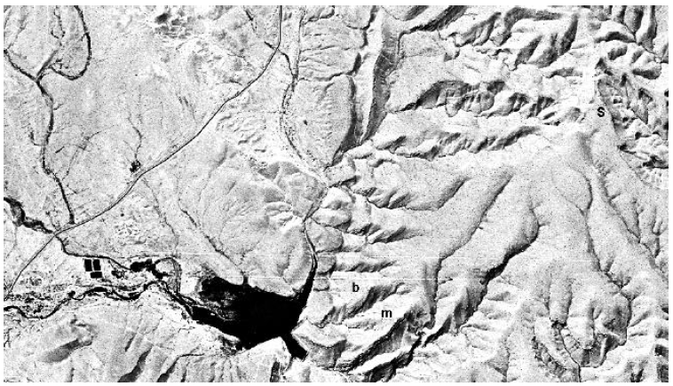
Figure 1 shows a satellite image[1] of a bamah, or high place, built four and a half thousand years ago. It is visible today in satellite photos, taken some 100 miles above the surface of the earth, because of the roughly circular stone boundary which surrounds and defines it. The ring of stones has a diameter of roughly 95 feet (30 meters) and encloses somewhat less than a quarter acre.
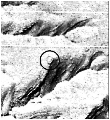 |
This bamah is located on a spur at the foot of Mount Yeroham in the desert of the northern Negev of Israel. I have previously presented chronological and archaeological data which forcefully imply that Mount Yeroham is the true Mount Sinai.[2] These same data also imply that the bamah shown in Figure 1 was built by Moses—that this high place is, in fact, the very one referred to in the verse above.
I first identified this bamah with Exodus 24:4 four and a half years ago.[3] Other pressing Biblical chronology research has kept me from the pursuit of this discovery since that time. But I am presently planning a trip to Israel, to present a paper at the 17th International Radiocarbon Conference later this summer, and I hope to follow up on this discovery with a visit to Yeroham while there. Preparation for this venture has provided opportunity to focus attention on this discovery once again. The present article is an interim report—interim between my initial identification four and a half years ago and the final report on my firsthand visit to Yeroham which I hope to share in future issues of The Biblical Chronologist. Its nature is deliberately exploratory and evocative rather than a rigorous logical demonstration at all points.
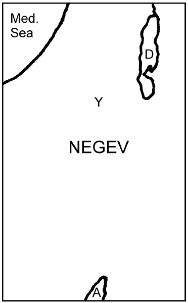
Nelson Glueck appears to have been the first archaeologist ever to have set eyes upon the bamah shown in Figure 1. His team discovered the site while conducting an extensive archaeological survey of the Negev (Figure 2) in the late 1950's.
 |
Glueck was aware from the start that this site appeared to have been built for religious rather than domestic purposes. He wrote:[4]
The wall around the lower hilltop [i.e., the ring of stones visible in Figure 1] was too poorly constructed ever to have served defensive purposes. At the most, it could have helped set it off as a particularly important place. …This hilltop seems to have been no ordinary site, and may well have served as a central sanctuary for the inhabitants of the area and the members of the passing caravans that halted below it at night by the side of the well of Bir Rekhmeh.
Though Glueck understood the basic function of the site—that it was a holy place—more or less immediately, he was entirely hindered by mistaken chronology from coming to a correct understanding of the proper Biblical historical setting of the site. He correctly assigned the secular chronology of the site to the Early Bronze IV period,[5] but his Biblical chronology was incorrect. Glueck did not know that "one thousand" is missing from the text of 1 Kings 6:1 today, resulting in an inadvertent loss of exactly 1000 years from traditional Biblical chronology.[6] As a result he mistakenly equated the Early Bronze IV period with the time of Abraham. He wrote as follows, for example, concerning the local setting of this Yeroham site (leaning more heavily on imagination than either archaeological or chronological data):[7]
It is easily possible that Abraham and his company may have camped there. Water and food and fellowship were available and an altar upon which to bring offerings of thanksgiving for the blessings of the way that lay behind and of supplication for assistance against the difficulties and dangers that loomed ahead. The culture of the Bir Rekhmeh [Yeroham] region was part of Abraham's own background, the farmers and shepherds dwelling there of his own relationship, the language they spoke being little different from his own, and the gods they worshiped familiar to him from his iconoclastic youth.In this Glueck was very much mistaken. Today it is altogether clear that unions of Biblical data from the time of Abraham with archaeological data from the Early Bronze IV period are chronologically inadmissible. Modern Biblical chronology has shown that the Early Bronze IV period is the time of the Israelites following the Exodus—the Early Bronze IV people are the Israelites after the Exodus—not the (much earlier) time of Abraham.[8] Abraham's time was some seven centuries earlier, in Early Bronze I.Had he indeed halted at Bir Rekhmeh, or at one or more of the other wells on his way from Canaan to Egypt and back again… he would have found villages to receive him hospitably, where he would have felt very much at home. There is little doubt in my mind but that that is exactly what happened.
Unfortunately, archaeologists are paying even less attention to the discipline of Biblical chronology today than they were in Glueck's day, so this fact is generally unknown to them still. But the truth is still the truth whether it is known or not, and modern Biblical chronology makes it quite clear that if Abraham had visited Bir Rekhmeh or any of the other wells along the way from Canaan to Egypt he would have found neither high place nor villages. Archaeological data clearly show, when once one has their Biblical chronology right, that the region was only barren, unpopulated desert back at the time of Abraham.
Other archaeologists have investigated the bamah and related archaeological remains on neighboring hills at the foot of Mount Yeroham since the early work of Glueck.[9] Moshe Kochavi directed excavations of the remnants of the main cluster of domestic/industrial buildings located on a separate spur next to the bamah in 1963. Rudolf Cohen conducted another excavation at the same site a decade later. But like Glueck, their lack of a proper understanding of Biblical chronology blinded them to the monumental significance of this ancient windswept desert high place.
Most of the archaeological work at Yeroham has been focused on the "main settlement". This is the tightly packed cluster of stone buildings just mentioned. These buildings were built on bedrock and covered about one acre on a hill adjacent to the bamah (Figure 3). The archaeologists have generally assumed that this cluster of buildings is representative of the domestic architecture and workshops of the Early Bronze IV people (whom they don't understand are the Israelites) who lived at Mount Yeroham (which they don't understand is Mount Sinai) and who built the high place (which they don't understand was built by Moses). The Biblical narrative suggests an entirely different view of these "main settlement" buildings however.
 |
There are two Biblical difficulties with the view that these buildings are normal Israelite dwellings. First, the number of buildings is far too few to have accommodated the Israelites, who, we are led to believe from the Biblical text, must have numbered several million.[10] These "main settlement" buildings could only have housed a few hundred people at best.
Second, the Bible tells us explicitly that the Israelites, "came to the wilderness of Sinai, and camped in the wilderness; and there Israel camped in front of the mountain" (Exodus 19:2, NASB, my emphasis). The "main settlement" excavated by the archaeologists is not in the wilderness (i.e., desert plain) in front of the mountain, it is on a steep hill at the foot of the mountain, the hill being part of the mountain itself. (See Figure 5.) Thus the "main settlement" does not fit the Biblical description of the location of the Israelite encampment at Sinai.
 |
One way to avoid these difficulties and still view this dense cluster of buildings as somehow normal to the Israelites would be to suggest that they were a special administrative or factory complex for the Israelite community. But the Biblical record of the Israelites' stay at Sinai suggests another explanation. It suggests that these buildings are distinctive and set apart from the main encampment of the Israelites because they belonged to a distinct group of people who were not Israelites. These people were the Midianites/Kenites, the in-laws of Moses. (Moses father-in-law is called a Midianite in Numbers 10:29 and a Kenite in Judges 1:16.)
That this distinctive ethnic element was present at Sinai is made clear in Numbers 10:29–32. This passage records Moses' entreaty to his brother-in-law, Hobab, as the Israelites were about to leave Sinai.
Then Moses said to Hobab the son of Reuel the Midianite, Moses' father-in-law, "We are setting out to the place of which the Lord said, 'I will give it to you'; come with us and we will do you good, for the Lord has promised good concerning Israel." But he said to him, "I will not come, but rather will go to my own land and relatives." Then he said, "Please do not leave us, inasmuch as you know where we should camp in the wilderness, and you will be as eyes for us." (Numbers 10:29–31, NASB)
The "main settlement" excavated by the archaeologists seems to suit this Midianite/Kenite element in two ways. First, it is appropriately situated on a steep-sided hill (one archaeologist describes the hill the bamah is built on as a "cliff") rather than down upon the plain. Numbers 24:21 (NASB) says of the Kenites, "Your dwelling place is enduring, and your nest is set in the cliff".
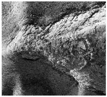
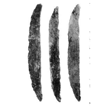
Second, copper ingots were discovered by the archaeologists in this "main settlement" at Yeroham (Figure 4), as also in similar settlements of the same period found throughout the Negev.
In another part of the main settlement, a hoard of 18 copper objects was found. The objects, which are elongated in shape and triangular in section, appear to be ingots cast in a primitive mould on the site.[11]
Particularly striking was the relatively high incidence of copper: pendants, awls, an intact dagger, and a hoard of several triangular ingots and a broken dagger, no doubt intended for resmelting.[12]This evidence of on site copper industry corresponds to what one might expect of the ancient Kenites. The Wycliffe Bible Encyclopedia explains:[13]
The term "Kenite" comes from qayin, which originally meant "metalworker, smith," as in Aram. and Arabic. … The Kenites apparently were nomadic or seminomadic clans of smiths…
 |
In light of these facts I suggest that the Early Bronze IV "main settlement" excavated by the archaeologists at Yeroham was the dwelling/workshop complex of the Midianite/Kenite clan of Hobab. This implies that these buildings should not be regarded as representative of the lifestyle and domestic architecture of the Israelites at Sinai, who seem from many Bible references to have lived in tents.[14] What the archaeologists have called the "main settlement" at Yeroham was not the principal settlement of the Israelites at all during the year they spent at Sinai. We may picture the principal settlement of the Israelites as many hundreds of acres of tents spread out in front of the mountain in the Sinai wilderness (i.e., the Yeroham basin—see Figure 5). The "main settlement" excavated by the archaeologists on the hill at the foot of Mount Yeroham [Sinai] today was at that time merely a minute ethnic suburb.
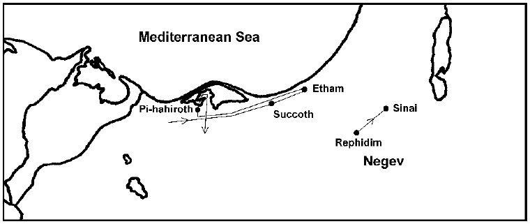
Further corroboration of this thesis comes from what is known so far of the route of the Exodus.[15] To the present time I have been able to trace the first three encampments of the Exodus (Succoth, Etham, and Pi-hahiroth) together with two other early stops (Rephidim and Sinai) (Figure 6). (I hope to fill in more of the route of the Exodus in the near future, as time to research this question comes available.) Of significance in the present context is the fact that structures of the "main settlement" [Midianite/Kenite] type found at Yeroham [Sinai] are not found at the archaeological sites corresponding to Succoth, Etham, or Pi-hahiroth, but are conspicuous at both Rephidim [Be'er Resisim] and Sinai [Yeroham]. This corresponds exactly to the Biblical narrative. The Midianites/Kenites are first seen in association with the Israelites at Rephidim according to the Bible. Exodus 18 records that Moses' father-in-law, Jethro, came to him at Rephidim bringing Moses' wife and two sons. While Jethro later left for his home[16] the presence of Hobab at Sinai, mentioned above, and the fact that the Kenites ultimately accompanied the Israelites into the promised land at the time of the Conquest[17] suggests a continuing Midianite/Kenite presence with Israel on their way to Canaan from Jethro's visit onward.
 |
I have been able to find only scant references to the bamah itself within the technical archaeological literature. Nelson Glueck gives this brief description:[18]
In the center of the enclosed area was a bare, rock surface which was pitted with seven cup holes. … It reminds one of the crude rock altar in the Mosque of Omar in Jerusalem…Moshe Kochavi describes it thus:[19]
Near this main settlement, on another spur, was a bamah (high place), consisting of a rock altar surrounded by a stone wall. …The bamah is merely a rock cliff, jutting out above the Yeroham Basin. At the top of the cliff is a leveled area with twelve cupmarks of various sizes. A stone wall, set a short distance back from the summit, encloses about a quarter of an acre of this area. No structural remains were found in the immediate vicinity of the rock altar.
Judging from these reports all that is to be seen today is bare bedrock, pitted with twelve cupmarks, surrounded by a stone wall.
We know from Exodus 24:4 that this high place originally contained additional furnishings. The text is quite explicit that Moses erected twelve pillars there, for example, one for each of the twelve tribes of Israel. It also seems certain that the bare bedrock did not serve as Moses' altar. Exodus 24:4 informs us that Moses built an altar, not that he cleared an altar. Instructions regarding altars were given by God through Moses to the people just prior to the construction of this high place. In these instructions we read:[20]
You shall make an altar of earth for Me, and you shall sacrifice on it your burnt offerings and your peace offerings, your sheep and your oxen; in every place where I cause My name to be remembered, I will come to you and bless you. And if you make an altar of stone for Me, you shall not build it of cut stones, for if you wield your tool on it, you will profane it.The concept here is clearly of a built altar, not merely a bare bedrock surface. Glueck's and Kochavi's assumption, evident in the quotes above, that the bare bedrock itself served as the altar, cannot be accepted as valid. We may safely conclude that in addition to the pillars, a built altar—probably of uncut stones, given the rocky nature of the site—also once stood upon the bedrock within the circle of stones.
All vestiges of the pillars and altar are evidently long gone from the site. The one type of furnishing which could not be carted away is the only type remaining today—the cupmarks.
I had originally thought these twelve cupmarks must have been sockets for the pillars.[21] Further reading within the technical archaeological literature suggests that this is incorrect. It suggests that these cupmarks were basins rather than sockets.
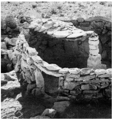
The Midianites/Kenites used stone pillars regularly within their houses to hold up the roofs (Figure 7). These domestic stone pillars did not employ sockets. Thus it is clear that Moses knew how to build stone pillars without the aid of sockets to keep them upright.
 |
Meanwhile, comparison with other ancient religious sites discovered by the archaeologists clearly implies the presence of basins at such sites. For example:[22]
Several features are usually present next to the upright stones: offering tables, altars and stone basins, often found in situ.
In point of fact basins are mentioned with respect to this high place in Exodus 24. After the high place had been constructed we read:
And he [Moses] sent young men of the sons of Israel, and they offered burnt offerings and sacrificed young bulls as peace offerings to the Lord. And Moses took half of the blood and put it in basins, and the other half of the blood he sprinkled on the altar.[23]
I suggest that the cupmarks discovered by the archaeologists at this high place are, in fact, the basins referred to in this passage. It was into these rock cut basins that half of the sacrificial blood was poured. The fact that the Moshe Kochavi reports exactly twelve cupmarks suggests that one basin was carved for each pillar in this particular instance.
With this view in mind it becomes possible to visualize the scene recorded for us in Exodus 24 in greater detail. Here is one possible reconstruction.
Moses rises early in the morning, gathers up a group of assistants, exits the camp out in the plain in front of the mountain, and makes the short climb to this spur of Sinai overlooking the Israelite encampment below. He builds an altar of readily available uncut stones at the crest of the spur. He erects twelve stone pillars, and carves a basin in the rock next to each pillar. Finally a stone boundary is placed around the site. He then sends young men down to the plain to fetch the sacrificial animals—one young bull from each tribe—and bring them back to the altar, and also to summon the people to the ceremony. As the animals are slain the sacrificial blood is caught in pottery vessels. Half of the blood is poured in the rock-cut basins, the other half is sprinkled on the altar where each animal is offered up in flames. At this point (Exodus 24:7–8) Moses reads the book of the covenant to the people, represented by elders grouped by tribe within the enclosure. When they assent to the covenant Moses takes blood from the basins in the rock, a different basin for each tribe, and sprinkles it on the corresponding tribal group of elders, sealing their covenant with God.
There has been much speculation by scholars regarding the symbolic significance of standing stones found at other ancient religious sites. It is not clear to me at the present time how comparable Moses' pillars are to the standing stones found at these other sites. The presence of basins in both instances does imply some degree of comparability. But the suggestion of some scholars that standing stones represented gods is clearly inappropriate to Moses' pillars.
In the present case the Biblical text tells us clearly that there was one pillar for each tribe of Israel, so we know that the twelve pillars were in some sense representative of the twelve tribes of Israel, not twelve gods. Let me attempt an alternate explanation in the case of these particular pillars.
The existence of stone pillars as roof supports in this same archaeological context clearly must have given stone pillars significance as the central structural member of houses in the minds of people of this time period and social setting. Thus a stone pillar could easily have been used as an abstraction of the concept of 'house'.
This suggests the possibility that the stone pillars Moses erected may have been symbolic of "houses". These "houses" would be the individual clans or tribes themselves—one pillar for the house (or tribe) of Levi, another for the house of Judah, and so on. In this way the fact that the covenant was binding upon each and every individual person of Israel—not just Moses and a few elders—would be symbolized. Each pillar represented an entire tribal household, making the twelve pillars inclusive of every Israelite. Possibly this is what Moses intended and what the people understood by the presence of these twelve pillars at this site.
One final point seems worth mentioning in relation to the pillars. Uzi Avner has compiled a list of 185 occurrences of sites having standing stones from a broad geographical expanse in the Near East and spanning thousands of years. Avner reports:[24]
The number of upright stones in the groups repeats itself consistently: singles [i.e., 1 column] in 49%, pairs [2] in 8%, triads [3] in 12%, quintets [5] in 4%, septets [7] in 9%, enneads [9] in 2% and groups of 16 in 3%. Other numbers are either extremely rare or non-existent.
It is clear from this that Moses was not imitating pagan practice or borrowing pagan ritual custom when he erected the pillars at Sinai. The fact that there were twelve pillars at Sinai places this site immediately in an "extremely rare" category. We may conclude from this—not surprisingly—that Moses' purpose with the pillars, and indeed the entire ceremony, was distinct from pagan custom.
The claim that the high place visible in Figure 1 is the very one built by Moses, referenced in Exodus 24:4b, is a remarkable claim, of course. It is remarkable that this high place should have survived in recognizable form for the four and a half millennia which separate Moses from us. It is remarkable not only that we should be able to identify the exact geographical location—the very spot—where the activities described in Exodus 24:4 took place, but also, indeed, the very basins in which the blood of the covenant was held. It is remarkable that we should be able to assign such a precise Biblical reference to this site and these basins. It is remarkable that we should be able to tell the name of the very person who constructed and used these basins. It is remarkable that this person should be Moses: the greatest prophet of antiquity; the man raised up by God to lead His people out of the iron jaws of Egypt; the man through whom God visited plagues of destruction upon ancient Egypt; the man who raised his staff and divided the sea so that the Israelites crossed over on dry ground, and who raised his hand again so that the waters returned drowning Pharaoh Merenre II[25] and all his army; the man through whom the law and the ten commandments were given, … It is remarkable that we should be able to set knowing eyes yet today on objects constructed and used by Moses. And it is remarkable that these objects should not be his tent or his robe or any other object of mundane existence, as incredible even as the discovery today of any of these things would be, but that these objects should be a part of this bamah—this holy place where Moses worshiped Jehovah, and from which he took the blood of the covenant and sprinkled it on the people, sealing them in solemn covenant as a people set apart unto Jehovah.
Yet, in another sense, this claim should not seem remarkable. Real history does leave trails, and some trails are not easily erased. This bamah is only one small piece of the durable trail of history which passage of several million people through the desert on their way from Egypt to Canaan four and a half thousand years ago must inevitably have left. The claim that this bamah is the very one built by Moses, recorded in Exodus 24, seems so extraordinarily remarkable to us today only because we have grown to expect no real trail from ancient Bible history. We have come to accept the foolish proposition that God's mighty acts of judgment and redemption in history somehow left no physical trace in the real world: that a nation could suffer the wholesale destruction of its economic, political, social, and religious fabric which the Bible teaches us Egypt suffered at the time of the Exodus, and history yield no clue; that two million people carrying "their kneading bowls bound up in the clothes on their shoulders"[26] could cross a barren desert, and somehow not so much as a single shard from a single broken kneading bowl be recovered from that same desert floor today; that twelve tribes of monotheistic pastoral nomads could descend upon Palestine, successfully conquer its cities and drive out its former, idol worshiping inhabitants, and archaeology be unable to detect so much as a nuance of change in the culture of the entire region.
Yes, these are foolish expectations. And as such the truly remarkable thing is not that they should be found so blatantly false, but that they should have been believed true by so many intelligent, capable people for such a long time.
In quantitative terms the problem resolves ultimately, of course, to a simple copy error, made in remote antiquity, which threw off traditional Biblical chronology—it resolves to a simple, inadvertent loss of "one thousand" years from the text of 1 Kings 6:1.[27]
But this brings us to the thing which is ultimately the most remarkable. I venture to predict that the only thing which will seem remarkable about this whole affair 100 years hence—should this present temporal realm endure so long—will be that so many capable individuals should have been so seriously misled for so long a time in the face of so much archaeological data by so small a thing as this simple copy error.
But, for the present, it is perhaps more profitable to meditate on the obvious than it is to wonder at the remarkable. The obvious lesson for us all is this: Biblical chronology must not be neglected. Scholarly neglect of the discipline of Biblical chronology this past hundred years has exacted a heavy price—a spiraling descent into foolishness on several fronts. The importance of Biblical chronology to a right understanding of history, and ultimately to a right understanding of the God Who has revealed Himself in history, we may safely conclude, is why the Bible has taken pains to supply us with vital and irreplaceable chronological data stretching back to the very dawn of Creation. Those who neglect this discipline or abuse these data do so to their own considerable detriment. ◇
I had expected to be able to report the final radiocarbon results on the Cave of the Treasure reed mat this issue.[28] Unfortunately, as of the time of writing I am still waiting on one final measurement. This is expected to be complete in several weeks, so I expect to be able to give a full final report on this research project next issue.
Two commercial satellite photos of the south side of Mt. Cilo, where IO3 was photographed in the 1960s, have now been ordered.[29] We are currently waiting on final acceptance of the orders by the commercial satellite company. One of the orders may involve some unusual tilting of the satellite camera, so acceptance is by no means a simple matter of routine. If the orders are accepted the satellite photos will be taken in the late summer, to allow sufficient time for meltback of snow cover. The major objective is to see if IO3 is still there on the side of Mount Cilo. Beyond this we are hoping that more of the true nature of IO3 might be apparent in these modern, high resolution digital images. Much will depend on factors beyond our control, such as the actual extent of meltback this summer and cloud cover at the time the photos are taken. We feel, however, that our chances of success with at least our major objective are high between the two attempts presently scheduled for this summer. ◇
The Biblical Chronologist is a bimonthly subscription newsletter about Biblical chronology. It is written and edited by Gerald E. Aardsma, a Ph.D. scientist (nuclear physics) with special background in radioisotopic dating methods such as radiocarbon. The Biblical Chronologist has a threefold purpose: to encourage, enrich, and strengthen the faith of conservative Christians through instruction in Biblical chronology, to foster informed, up-to-date, scholarly research in this vital field within the conservative Christian community, and to communicate current developments and discoveries in Biblical chronology in an easily understood manner. An introductory packet containing three sample issues and a subscription order form is available for $9.95 US regardless of destination address. Send check or money order in US funds and request the "Intro Pack." The Biblical Chronologist (ISSN 1081-762X) is published six times a year by Aardsma Research & Publishing, 412 N Mulberry, Loda, IL 60948-9651. Copyright © 2000 by Aardsma Research & Publishing. Photocopying or reproduction strictly prohibited without written permission from the publisher.
|
^ The satellite photo shown is from declassified military film taken September 29, 1971. It was purchased from the U.S. Geological Survey EROS Data Center. The ordering identifier for this film is DS1115-2300DF053.
^ Gerald E. Aardsma, "Yeroham—The True Mt. Sinai?" The Biblical Chronologist 1.6 (November/December 1995): 1–8.
^ Gerald E. Aardsma, "Yeroham—The True Mt. Sinai?" The Biblical Chronologist 1.6 (November/December 1995): 1–8.
^ Nelson Glueck, Rivers in the Desert: A History of the Negev, Evergreen Encyclopedia Volume 5, (New York: Grove Press, Inc, 1959), 83.
^ Glueck refers to Early Bronze IV as Middle Bronze I. Others call it Intermediate Bronze. In The Biblical Chronologist I use a third common convention which designates the period as Early Bronze IV. Which of these three one chooses is arbitrary as far as Biblical chronology is concerned; it has no significance other than being a convenient label for a distinctive period/culture in Palestine.
^ Gerald E. Aardsma, A New Approach to the Chronology of Biblical History from Abraham to Samuel, 2nd ed. (Loda IL: Aardsma Research and Publishing, 1993).
^ Nelson Glueck, Rivers in the Desert: A History of the Negev, Evergreen Encyclopedia Volume 5, (New York: Grove Press, Inc, 1959), 83.
^ Gerald E. Aardsma, "The Chronology of Palestine in Relation to the Bible: 3000–1000 B.C.," The Biblical Chronologist 1.4 (July/August 1995): 1–6.
^ Moshe Kochavi and Rudolf Cohen, "Mount Yeroham," The New Encyclopedia of Archaeological Excavations in the Holy Land, vol. 4, ed. Ephraim Stern (New York: Simon & Schuster, 1993), 1506–1509.
^ Gerald E. Aardsma, "Yeroham—The True Mt. Sinai?" The Biblical Chronologist 1.6 (November/December 1995): 2.
^ Moshe Kochavi, "Har Yeruham," Israel Exploration Journal 13 (1963): 142.
^ William G. Dever, "Be'er Resisim," The New Encyclopaedia of Archaeological Excavations in the Holy Land, vol. 1 (New York: Simon & Schuster, 1993), 159.
^ John Rea, "Kenite," Wycliffe Bible Encyclopedia, vol. 2, ed. Charles F. Pfeiffer, Howard F. Vos, John Rea (Chicago: Moody Press, 1975), 986.
^ For example, Exodus 18:7.
^ Gerald E. Aardsma, "Yeroham—The True Mt. Sinai?" The Biblical Chronologist 1.6 (November/December 1995): 1–8; Gerald E. Aardsma, "The Route of the Exodus," The Biblical Chronologist 2.1 (January/February 1996): 1–9.
^ Exodus 18:27.
^ Judges 1:16.
^ Nelson Glueck, Rivers in the Desert: A History of the Negev, Evergreen Encyclopedia Volume 5, (New York: Grove Press, Inc, 1959), 83.
^ Moshe Kochavi and Rudolf Cohen, "Mount Yeroham," The New Encyclopedia of Archaeological Excavations in the Holy Land, vol. 4, ed. Ephraim Stern (New York: Simon & Schuster, 1993), 1506–1507.
^ Exodus 20:24–25.
^ Gerald E. Aardsma, "Yeroham—The True Mt. Sinai?" The Biblical Chronologist 1.6 (November/December 1995): 7.
^ Uzi Avner, "Ancient Cult Sites in the Negev and Sinai Deserts," Tel Aviv 11 (1984): 115–131.
^ Exodus 24:5–6.
^ Uzi Avner, "Ancient Cult Sites in the Negev and Sinai Deserts," Tel Aviv 11 (1984): 115–131.
^ Gerald E. Aardsma, A New Approach to the Chronology of Biblical History from Abraham to Samuel, 2nd ed. (Loda IL: Aardsma Research and Publishing, 1993), 78–80; Gerald E. Aardsma, "The Chronology of Egypt in Relation to the Bible: 3000–1000 B.C.," The Biblical Chronologist 2.2 (March/April 1996): 1–9.
^ Exodus 12:34.
^ Gerald E. Aardsma, A New Approach to the Chronology of Biblical History from Abraham to Samuel, 2nd ed. (Loda IL: Aardsma Research and Publishing, 1993).
^ Gerald E. Aardsma, "Radiocarbon Dating Noah's Flood – Part II" The Biblical Chronologist 6.2 (March/April 2000): 1–11.
^ See Gerald E. Aardsma, "Research in Progress," The Biblical Chronologist 5.3 (May/June 1999): 7–16 for background on this research project.