|
|
|
|
|
|
|
Home
About
Resources
anti-aging vitamins books
- A New Approach...
- The Exodus Happened 2450 B.C.
- Noah's Flood Happened 3520 B.C.
- Age of the Earth Collection
- Aging: Cause and Cure
- Bread from Heaven: The Manna Mystery Solved
newsletters
podcast
speaker for an event
time charts
videos
Topics
Overview
Biblical Chronology Dendrochronology Radiocarbon Dating Mt. Sinai Jericho Ai The Exodus Noah's Ark Imhotep/Joseph
Correspondence
- anti-aging vitamins
- antiquity of mankind
- ark search
- Bible chronology
- "The BC" publication
- Bryant Wood's critique
- calendars
- Heshbon
- horses and chariots in Egypt
- Jericho --- Joshua's curse
- lifespan research
- missing millennium: reception
- missing millennium: textual
- Mt. Sinai
- Noah's Flood
- Philistines
- radiocarbon
- Sodom and Gomorrah
- teaching science and creation
- the Exodus
- tree rings
- virtual history
- young earth creation
Contact Us
In Search of Noah's ArkThe following article is a greatly condensed introduction to information and discussion pertinent to the search for Noah's Ark contained within the pages of The Biblical Chronologist research newsletter.A Fresh ApproachIn spite of enormous effort, and a few false alarms, Noah's Ark still hasn't been found. Dr. Gerald Aardsma of The Biblical Chronologist has taken a fresh approach to the search for Noah's Ark. The Bible says that Noah's Ark landed in "the mountains of Ararat". Ararat refers to a region, not a specific mountain. Dr. Aardsma decided to use both biblical and scientific data in a new way to search for Noah's Ark in that region.  Clues, Maps, and Computer ProgramsThe Bible provides a lot of detail about the Flood, the Ark, and the mountain the Ark landed on. Additional information about the location of the mountain the ark came to rest upon can be inferred from certain clues within the biblical text. For example:
Out of 1,441 "mountains" in the Ararat region, only 41 fit clue 1 above. This was determined based on the curvature of the earth's surface and the elevations and locations of the 1,441 mountains. A custom-designed computer program did the math for each candidate. 1,400 mountains were eliminated, but there were still 41 remaining candidates to choose from. Dr. Aardsma then obtained characteristics such as elevation and location for the remaining candidates. By inputting these characteristics into another custom-designed computer program, each candidate was rated according to how well it fit the biblical clues. It was no surprise that Mt. Ararat rated very well. It was a surprise that it ranked second, not first. Even more surprising, the top-ranked candidate fit the clues 62 times better overall than Mt. Ararat! The top-ranked candidate is called Cilo Dagi. We've nicknamed it Mt. Cilo. 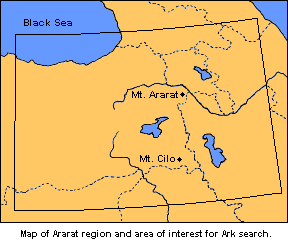 Is the Ark on Mt. Cilo?Since the ark is such a large object, it made sense to try to obtain satellite photos of Mt. Cilo to see what might be visible there. With the help of research partner Bert Hawley some photographic enlargements of satellite photos from public archives were obtained. Visual examination of the photos revealed some objects that didn't seem to fit with their surroundings. After considerable investigation, IO3 (Interesting Object #3) prevailed as the most likely candidate for Noah's Ark. 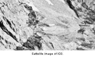 New Photo Obtained September, 2001In September, 2001 a new, custom satellite photo of IO3 was obtained. The Biblical Chronologist purchased this photo from Space Imaging. It was shot specifically for us by the IKONOS satellite. The area of interest from the new photo is shown here. 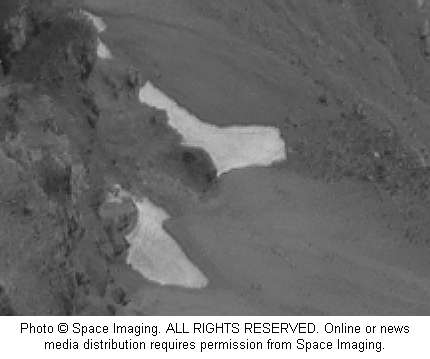 What was exciting about the new photograph was not so much what was different than the photos from the 1960's, but rather what was not different. There was still an interesting object there after 40 years of weather and seasons. Notice the excellent resolution of the new image in comparison to the older image above. Google Maps satellite imagery 2008In February 2008, Dr. Aardsma used publically available satellite coverage of the Mt. Cilo area as a check on IO3. Resolution of the satellite image was the best ever, the photographic angle was different than previous satellite images (much more directly overhead), and snow cover was less than previously. No trace of IO3 could be found in this new satellite image. Thus it appears that IO3 is not the ark. IO3's similarity to the ark appears to result from natural landscape features viewed from a particular angle. ConclusionWhile IO3 does not appear to be the ark, the Mt. Cilo area continues to be the most probable landing place for the ark. As freely-available satellite imagery of the region continues to come available, at ever-increasing resolution, the chances of finding whatever remains of the ark continue to improve. We'll keep looking, and keep you posted on whatever we find. Major articles on this topic can be found in The Biblical Chronologist Volume 3, Number 2, The Biblical Chronologist Volume 5, Number 3, and The Biblical Chronologist Volume 7, Number 3. |