A New Approach to the Chronology of Biblical History from Abraham to Samuel.  112 pages. $29.95. Click for details. The Exodus Happened 2450 B.C.  94 pages. $29.95. Click for details. Noah Aging: Cause and Cure.  143 pages. Free download. Click for details. Bread from Heaven: The Manna Mystery Solved. 111 pages. Click for details.
 
  Advanced Search
Sign Up

Home

About

Resources
anti-aging vitamins books manna
newsletters
podcast
speaker for an event
time charts
videos
Topics
Overview
Biblical Chronology Dendrochronology Radiocarbon Dating     Mt. Sinai Jericho Ai The Exodus Noah's Ark Imhotep/Joseph
Correspondence

Contact Us

BC Volume 6 (2000)


Volume 6, Number 1January/February 2000

Elk Lake Revisited

Prelude

From time to time I feel an urge to communicate some of my discoveries beyond the boundaries of the modest circulation of The Biblical Chronologist. I feel a sense of responsibility especially toward fellow scientists. My work is at the interface of science and the Bible, and discoveries at this interface can greatly impact one's worldview. I have always felt that if someone else were to make these discoveries, I would certainly want to be informed of them. A simple application of the Golden Rule says I should try to inform others.

But a bit of a sinking feeling always damps my enthusiasm when I undertake one of these communication projects. Experience has shown repeatedly that most individuals, scientist or otherwise, are not very receptive to discoveries which challenge their accustomed way of thinking. This observation extends far beyond my own experience. The pages of history are replete with instructive instances. Let me briefly review a few facts in relation to Galileo's struggles with fellow scientists, which I have previously discussed in greater detail.[1]


Galileo, having greatly improved the recently invented telescope, was the first to observe that the surface of the moon was cratered. Also by use of this improved instrument he was able to observe that moons orbited Jupiter.

Unfortunately, both of these observations were unthinkable at the time. Traditional wisdom of respectably ancient lineage held that the surfaces of all heavenly bodies were geometrically perfect spheres, and that all celestial objects orbited the earth.

The reception Galileo's discoveries received from fellow scientists is revealed in a letter from Martin Horkey, associate of internationally renowned astronomer Giovanni Antonio Magini, to the now famous astronomer Johannes Kepler.[2]

Galileo Galilei, the mathematician of Padua, came to us in Bologna and he brought with him that spyglass through which he sees four fictitious planets [ i.e., moons of Jupiter]. On the twenty-fourth and twenty-fifth of April I never slept, day and night, but tested that instrument of Galileo's in innumerable ways, in these lower [earthly] as well as the higher [realms]. On Earth it works miracles; in the heavens it deceives, for other fixed stars appear double. Thus, the following evening I observed with Galileo's spyglass the little star that is seen above the middle one of the three in the tail of the Great Bear, and I saw four very small stars nearby, just as Galileo observed about Jupiter. I have as witnesses most excellent men and most noble doctors, Antonio Roffeni, the most learned mathematician of the University of Bologna, and many others, who with me in a house observed the heavens on the same night of 25 April, with Galileo himself present. But all acknowledged that the instrument deceived. And Galileo became silent, and on the twenty-sixth, a Monday, dejected, he took his leave from Mr. Magini very early in the morning. And he gave no thanks for the favors and the many thoughts, because, full of himself, he hawked a fable. Mr. Magini provided Galileo with distinguished company, both splendid and delightful. Thus the wretched Galileo left Bologna with his spyglass on the twenty-sixth.

Several years ago I submitted a paper to a secular scientific journal arguing, as I had previously done in The Biblical Chronologist, that the chronology of laminated sediments from Elk Lake, Minnesota had been misinterpreted.[3] The original researchers had interpreted a thick section of anomalous sediment as spanning a six hundred year interval. I pointed out that this interpretation encountered numerous contradictions from the Elk Lake data themselves. I argued that to avoid these contradictions it was necessary to interpret this anomalous section as due to a single brief episode of intense deposition. I suggested that careful radiocarbon measurements should be able to resolve the true chronology of the anomalous section, and I suggested that such a check should be carried out to settle the issue.

I would like to have added that the anomalous section dated to the time of Noah's Flood, implying that Noah's Flood was, in fact, the explanation of the anomalous section of sediment in question. But I knew that mention of Noah's Flood in a way which treated it as real history would almost certainly guarantee rejection of the paper by the journal editor prior even to the usual peer review process. Prudence demanded that I attempt this communication in two stages: 1. establish the fact that there was a big chunk of sediment at Elk Lake which was deposited in a single brief episode rather than 600 years, and, once that was accomplished, 2. point out that this single brief episode was synchronous with the date of Noah's Flood calculated by modern Biblical chronology, and suggest that Noah's Flood provided the only reasonable explanation of the anomalous sediments.

I heard back from the editor five months later. The paper had been rejected following peer review. But the editor cordially offered, "If you can make a strong case, based on further evidence or reasoning, that would refute the referees assessments, we would welcome hearing from you".

The referees—including the scientist who had interpreted the anomalous section of sediments in terms of 600 years of slow deposition to begin with—did not deny that there were problems with the 600 year interpretation. But to accept the idea that the anomalous section of sediments was deposited during a single brief episode, and allow the paper to be published, both referees felt, as the editor summarized, that "a reasoned explanation of the rapid accumulation of the layered sediments is required".

Well, they had me there. The chronology issues should have been able to be treated by themselves on the basis of chronological data alone. But the referees were demanding to see a physical model for rapid accumulation of layered sediments at Elk Lake before they would allow the chronological issues even to be surfaced. The only way I could begin to give a "reasoned explanation of the rapid accumulation of the layered sediments" at Elk Lake was to bring Noah's Flood into the picture. And I seriously doubted their ability to give that idea a fair hearing.

I pondered my dilemma off and on for a year, but I could find no solution. Eventually I decided I had no choice. I had to state in the paper that the anomalous section of sediment found reasonable explanation only within the context of a historical Flood. The alternative was to forget trying to communicate the implications of Elk Lake sediments to my scientific colleagues altogether—which was fine with me, I had several plates full of other interesting discoveries in progress which were more than enough to keep me occupied. But there was still the Golden Rule to reckon with. The door hadn't been entirely slammed in my face yet. Who could say but that the editor and referees might rise above history's norm in this one instance…? (I tend toward an overriding optimism about people. Life has been trying to beat this out of me, but still it persists.)

So I enlarged the original paper to include an explanation of the anomalous sediments in terms of Noah's Flood. I showed that the secular date for this anomalous sediment from Elk Lake coincided with the Biblical date of Noah's Flood. And I summarized the archaeological and geophysical evidence for the historical reality of Noah's Flood which I have discussed in previous issues of The Biblical Chronologist. The thrust of the original paper was retained (i.e., there is a chronological problem with the Elk Lake sediments which needs to be resolved). And most of the original discussion was retained. In short, it was the same paper with an added explanation of how the anomalous laminated sediments might have been rapidly deposited, to meet the demands of the referees.

Well, at least I didn't need to wait five months for a reply this time. A very definitive rejection was forthcoming in just six weeks. And this time the editor did not volunteer that I should write again with any further thoughts.

Since the editor had sent the original paper out for review, he had had little choice but to send the enlarged version out also—despite its reference to a historically real Noah's Flood. That is why it took all of six weeks for the reply. He chose a different set of two reviewers for the enlarged paper. Their comments were not models of scientific objectivity. I will spare you the full treatment; here is a sample:

This paper is not science, not even pseudo-science. Its approach to varve analysis requires enormous faith and not any factual grasp of reality. I wouldn't even call this paper speculation. There is no evidence presented that can be used speculation. [That is how the preceding sentence appears in the original; I do not know how to emend it since I am not sure what it was meant to say. – G.E.A.] There appears to be such a rampant desire to show the existence of a catastrophic flood that the paper is blind to what can and cannot be substantiated or what is even realistic. There is NO support for any of the author's assumptions, which are necessary for any part of this house of cards to have credibility.

Well, as you can see, all it takes to demote a paper from serious science—demanding of a five month review process—to "not even pseudo-science" is reference to a historically real Noah's Flood.

Introduction

Elk Lake, in Minnesota, is a special lake for the scientific study of the past. In contrast to most lakes, it has well preserved laminated sediments. This results from the fact that Elk Lake is quite deep relative to its surface area, which makes it difficult for natural processes to supply the deepest parts of the lake with oxygen. As a result, macroscopic organisms which need oxygen to live—such as fish, worms, and clams—and which constantly mix the sediments at the bottom of most lakes, are unable to do so at the bottom of Elk Lake.

A lake's sediments are rich with certain kinds of information about its past. For example, pollen spores recovered from the sediments reveal the types of vegetation which surrounded the lake in the past. One can deduce past windiness in the vicinity of the lake by the amount and character of dust found within the lake's sediments. Other measurable parameters having distinct contributions to make to the story of the lake's past include, for example: types of diatoms which grew within the lake; elements and stable isotopes of sedimentary components, bulk magnetic properties, and fossil pigments.

Elk Lake's well preserved, laminated sediments greatly enhance its story of the past because they provide it with a simple chronological framework. At Elk Lake it is possible to deduce with some assurance not only what happened, but also when it happened.


Elk Lake is a particularly special lake for the science of Biblical chronology. It is special because its history intersects Bible history. The intersection point occurs at Noah's Flood.

The Bible informs us that a massive flood—Noah's Flood—happened in ancient history. Floods are ideal for making sediments. Elk Lake is a deep basin, ideal for catching and preserving sediments.

Modern Biblical chronology dates Noah's Flood to 3520±21 B.C. Elk Lake's layered sediment chronology reveals that the lake existed continuously from thousands of years prior to that date, down to the present time. Simply stated, Noah's Flood happened within the span of history recorded in Elk Lake's sediments.

Clearly, Elk Lake's sediments must have something to say about the nature of Noah's Flood. And its carefully preserved laminations provide us with the chronological framework we need to know where to look to discover what that something is.

Figure 1 shows the measured annual sedimentary layer thickness at Elk Lake, as the laminations are interpreted by Roger Y. Anderson et al.[4] Layer 1 in the figure corresponds to a layer of sediment near the top of the great depth of laminated sediments found at the bottom of Elk Lake. Layers are counted from the top to the bottom of the sedimentary column.

Figure 1: Elk Lake laminated sediment chronology as constructed by original researchers. (See text for reference.) For greatest visual clarity only the thickest and thinnest layers are plotted from each consecutive group of twelve layers. The layer number is given by the scale on the left in units of thousands.

The history of the lake divides naturally into three stages as shown in Figure 1: 1. Post-glacial, 2. Prairie, and 3. Modern. During the first stage the climate in the vicinity of the lake was cold and moist. This resulted from the proximity of the lake to the slowly retreating glaciers which had formed the lake. The lake was surrounded by coniferous forests during this Post-glacial stage.

As the glaciers continued to retreat, air crossing the mountains from the Pacific was able to reach further to the north and east. This resulted in a drier, warmer climate at Elk Lake. The coniferous forest was replaced by dry prairie vegetation around the lake in response to this shift in local climate.

Moisture increased once again in the vicinity of the lake beginning about 3800 years ago according to the time scale of Figure 1. This appears to have resulted from an extension northward of the tropical airstream from the Gulf of Mexico. The result was displacement of prairie vegetation around the lake by mixed pine and hardwood forests.

All of this is fairly easily read from the plentiful scientific data recovered from Elk Lake's sediments.[5]

The only real curiosity is the section of layered sediments labeled "Anomaly" in the figure.

This is a section of 600 thin, uniform, striated laminations,[6] bordered on both sides by thick, variable laminations.

The thick, variable laminations are diagnostic of the Prairie lake stage. They result from wind-blown dust fertilizing the lake and settling to the bottom. Because of the dry and relatively open conditions during the Prairie stage, it was relatively easy for strong winds to blow near the surface of the ground, and for dust to be lofted into the air from dry soil.

Once this is understood it is natural to suppose that the 600 thin uniform layers must represent a period of temporarily increased moisture. This, in fact, is what the original researchers proffer as the explanation of this anomaly.

The long-term changes in soil moisture that [hypothetically] at first increased and then lowered the threshold, shutting off and then turning on dust suspension, probably were more gradual than indicated by the event itself, occurring in an interval that was longer than 600 yr. This suspected longer interval must have been accompanied by a significant increase and later decrease in moisture in order to account for the event.[7]

In contrast to this "significant increase in moisture" theory, I have previously proposed that this entire anomalous section of thin, uniform laminations was deposited in a brief period of time as a result of Noah's Flood.[8] The laminated character of this anomalous section is attributed to physical processes active during the Flood, such as tidal phenomena, rather than to annual seasonality in this theory.

I advanced my theory on the strength of two considerations. First, Noah's Flood dates to the trailing edge of this anomalous interval, as shown in Figure 1. It seems improbable that the Flood, which has every reason to have produced unusual sedimentation at Elk Lake, should synchronize with the only anomaly in the entire series of roughly 10,000 annual layers at Elk Lake, and that anomaly have nothing in fact to do with the Flood. When the calendrical chronology of the sediments is calculated assuming the entire anomalous section is due to deposition within a single year, the remarkable chronology of layer thicknesses shown in Figure 3 results.[9]

Figure 3: Elk Lake laminated sediment chronology as constructed by Aardsma. (See text for reference.) For greatest visual clarity only the thickest and thinnest layers are plotted from each consecutive group of twelve layers.

Second, the significant-increase-in-moisture theory seems unable to provide a rational, cohesive explanation of much data from this anomalous interval.[10] As a single (previously discussed) example, a 600 year interval of significantly increased moisture should yield significant changes in the types of vegetation surrounding the lake. This was the case, for example, when moisture increased in the Elk Lake region roughly 3800 years ago (Figure 1). But pollen from the anomalous section fails to reveal any shift in the types of vegetation around the lake during this interval.[11]

In the present issue I take us back to the Elk Lake sediments. My purpose is to show that additional analyses of data from Elk Lake continue to falsify the significant-increase-in-moisture theory and to corroborate the Flood theory of the origin of the anomalous 600 layers. The objects of interest to the present study are microscopic cysts found within the sediments of Elk Lake (Figure 2).[12]

Figure 2: Examples of cysts obtained from Elk Lake sediments by Barbara Zeeb and John Smol. (See text for complete reference with additional examples.) Photos were obtained using a scanning electron microscope. The scale bars are 2 microns (79 millionths of an inch).

Cysts at Elk Lake

A cyst consists of a thin "shell" made of silica (the major constituent of sand). Cysts are produced by certain types of algae (nonvascular and often single-celled plants). Different species of algae produce cysts which differ from one another in size and appearance. Cysts serve algae as a protective "house" in which to live for a period of time. Eventually the alga cell reemerges from the cyst through a small opening called a pore.

The importance of cysts to the present study lies in the fact that algae are sensitive to their environment. Species of algae differ in their respective tolerances to various environmental conditions. For example, some algae prefer cooler temperatures while others do better in warmer conditions. This selective sensitivity to environmental conditions immediately suggests the possibility of using cysts recovered from Elk Lake's ancient sediments to learn about conditions in the lake in the past.

Salinity

In the present context we are particularly interested in learning about the salinity of Elk Lake in the past. Our reason for this interest is somewhat obvious. Elk Lake is normally a freshwater lake. At the time of the Flood it was flooded by ocean water, according to the hemispherical Flood model. Since ocean water is salty, it has a higher density than fresh water. We confidently predict, therefore, that Elk Lake's fresh water was displaced by saline ocean water at the time of the Flood.

It seems likely that Elk Lake would have remained unusually salty for a long time following the Flood. To rid the lake of excess salt requires dilution and flushing with fresh water. But the lake experienced a dry prairie climate for a millennium following the Flood (Figure 3), so the fresh water contribution to the lake back at that time was probably limited. Furthermore, since salt water is denser than fresh water, stratification of the lake following the Flood is probable. Cold, salty water would naturally tend to settle into the deepest portions of the lake. Mixing of these deep saline waters with overlying fresh water would not have been easily accomplished.

In summary, the Flood thesis predicts a sudden influx of salt water to the Elk Lake basin synchronous with the anomalous 600 layers, and persistent elevated saltiness for a significant length of time following the anomalous layers.

A very different prediction follows from the significant-increase-in-moisture theory. Increasing moisture through change in climate is expected to decrease the salinity of the lake. There are only two ways to increase soil moisture (so dust stops blowing into the lake): 1. increase precipitation, or 2. decrease evaporation. In either case lakes in the region should become less salty.

Temperature

The past temperature of the lake is also of some interest. The significant-increase-in-moisture theory makes no prediction regarding temperature during the anomalous 600 layers, but the Flood theory predicts that the lake water should become very cold. This results from the fact that, while the top few meters of the oceans may be quite warm, most of the water of the oceans is deep ocean water, and deep ocean water is only a few degrees above freezing (typically 1–4°C).[13]


Might the selective sensitivity of algae to environmental conditions be exploited to test these two theories? Might the record of the number density of various types of cysts in Elk Lake's laminated sediments reveal what really happened at Elk Lake at the time of the Flood? Though here, as in many areas of Biblical chronology research, we necessarily labor at the frontier of a scientific discipline, the work of Barbara Zeeb and John Smol suggests that the answer to both of these questions is yes.

Experimental

Zeeb and Smol have painstakingly counted and categorized well over 30,000 cysts from 105 sediment levels at Elk Lake.[14] They have analyzed their numerical data using a statistical method known as "principle components analysis" (PCA). This method separates out independent causes of observed (colinear) variablity in a dataset.

Zeeb's and Smol's PCA diagram for the interval from 10,400 laminated sediment years ago to 3100 laminated sediment years ago is shown in Figure 4. Zeeb and Smol caution that, due to the newness of the whole field of cyst analysis, they cannot be certain which environmental variable is responsible for the variations of their dataset which the PCA analysis has separated out and they have plotted as "PCA axis 1" and "PCA axis 2". Nonetheless, by comparing their PCA analysis with what is know of the climatic history of Elk Lake, they suggest that PCA axis 1 corresponds to temperature and PCA axis 2 corresponds to salinity, as shown in Figure 4.

Figure 4: PCA diagram for cyst data obtained from Elk Lake sediments. (After Barbara Zeeb and John Smol; see text for complete reference.) PCA axis 1 explains 40% and PCA axis 2 explains 18% of the total variance. Each plotted point corresponds to a cyst assemblage at a unique depth in Elk Lake's sediments. The development of the lake in terms of temperature and salinity can be traced in time by following the dashed lines from point to point. Time references are given for many points, based on counts of sedimentary layers. The heavy dashed arcs separate out combinations of temperature and salinity which persisted through a significant depth of sediment.

PCA axis 2 is labeled "wet" and "dry" in conformity with Zeeb's and Smol's original figure. This refers to climate around the lake, not conditions in the lake itself. The algae, which live in the lake, are always wet, of course. They are not sensitive to wet and dry climate directly, but rather to salinity of the water in which they live, which increases when the climate is dry and decreases when it is wet. When referring to the lake itself, rather than climate, PCA axis 2 should be labeled "saline" in place of dry, and "fresh" in place of wet. I have added these labels to the right hand axis of Zeeb's and Smol's original figure for ease of reference in the present discussion.

Results

Figure 4 starts the lake out (double square in PCA diagram) in a cold, fresh condition 10.4 ky (10,400 years) ago. This is as expected. Cold, fresh water is expected within the newly formed lake following retreat of the glaciers toward the north and east.

This condition persisted, according to the PCA diagram (Figure 4), until about 8,500 years ago. This was the Post-glacial lake stage. It is set off by the dashed arc at lower right in the PCA diagram.

The lake then warmed, and began to increase in salinity. This is in agreement with conditions expected of the dry Prairie stage, which the climate around the lake had now entered.

The lake then slowly reduced salinity while continuing to warm, from about 7400 to 5600 years ago. This is the regime set off by the dashed arc at the left of the PCA diagram.

The net trend from the inception of the lake to this point in time was significant warming and moderate increase in salinity.

At this point, in approximate synchronization with the anomalous section of sediment, the lake suddenly transitioned out of the warm, moderate salinity regime and into a cold, saline regime, set off by the dashed arc at upper right in the PCA diagram. This transition is in accord with the predictions of the Flood explanation of the anomalous section of sediment.

Chronological Hitch

A small hitch—which we must now pause to deal with—is that the transition to the cold saline regime shown in the PCA diagram appears to predate the onset of the anomalous 600 layers by 200 years. The anomaly runs from 5300 to 4700 laminated sediment years ago (Figure 1). The PCA diagram shows the cold saline regime lasting from 5500 to 4900 years ago—a 200 year offset.

While it may be possible to accommodate such an offset within the Flood theory, it seems more probable to me at present that this 200 years is artifactual only, resulting from chronological error in the PCA diagram.

A chronological offset of 100 years is found almost everywhere in connection with discussion of the boundaries of this 600 "year" anomaly within the GSA volume devoted to Elk Lake in which Zeeb's and Smol's paper is found.[15] It is most often referred to as beginning 5400 and ending 4800 years ago, though the closest century boundaries of the anomalous section in the laminated sediment chronology (Figure 1) are clearly 5300 and 4700 respectively. (See Figure 6 of Bradbury et al.[16] for an expanded view.) Anderson et al. claim the laminated sediment chronology is used throughout the GSA volume:

For all chapters in this volume, the following conventions are used for time designations: ka (for kilo annum) = thousands of varve years ago, T0 = A.D. 1927 (the beginning of Elk Lake varve chronology);[17]
but this is evidently not the case, at least in regard to this anomalous section.

Zeeb and Smol explicitly state that beginning 5300 and lasting to 4800 years ago "dominant cysts indicate a striking return to early postglacial conditions".[18] This seems in obvious contradiction to their PCA diagram (Figure 4) which shows the dramatic shift back to cold conditions running between 5500 and 4900 years ago.

Zeeb and Smol mix "ka" and "ky" as the unit meaning "thousands of years ago" in the PCA diagram. One wonders whether they intended a different origin of coordinates in the two cases, possibly explaining the apparent chronological offset of the PCA diagram. But they also mix these units throughout the body of their paper, and there they appear to be used synonymously.

To further compound the puzzles with the detailed chronology of this paper, their Figure 3 shows a curious nonlinearity in its timescale between 5500 and 5000 years ago.

My best guess is that the figures for Zeeb's and Smol's paper were drafted before fine tuning of the laminated sediment chronology was complete. Subsequent editing updated some of the text, but failed to make all the changes which were needed.

Significant-Increase-In-Moisture Theory

Be that as it may, what is absolutely clear is that the prediction of the significant-increase-in-moisture theory (that the climate was more moist during the anomalous sediments interval) fails entirely. The PCA diagram shows an unequivocal transition to drier (more saline) conditions during this anomaly, in exact contradiction to the significant-increase-in-moisture theory.

Something highly unusual happened at Elk Lake during this anomaly, sending it into an unprecedented temperature - salinity regime. This is most easily seen in Figure 5, which includes all of Zeeb's and Smol's data from the birth of the lake to relatively modern times. The heavy dashed line in the figure shows that the data points between 5.5 ka and 4.1 ka are in a separate region unto themselves. In Zeeb and Smol's words: "It is interesting that cyst assemblages from 5.5 to 4.1 ky are unique, and have no other analogues during the lake's history".[19] It is clear that the lake experienced something far more unusual than a simple increase in moisture at this time.

Figure 5: Composite PCA diagram for entire cyst dataset obtained from Elk Lake sediments by Barbara Zeeb and John Smol. (See text for complete reference.)

Flood Theory

While the PCA results are in blatant contradiction to the significant-increase-in-moisture theory, they strongly corroborate the Flood theory for the origin of the anomalous sediments. The lake not only became suddenly very saline, it also became suddenly very cold at the time of the anomaly—both of which are necessary if deep ocean water flooded Elk Lake basin as the Flood theory predicts. Following the anomalous sediments interval (i.e., following the Flood) the PCA diagram shows that the lake quickly warmed to normal temperatures again, as one would expect. And, as anticipated in the discussion above, high salinity persisted in the lake for an extended time. Only with the coming of the Modern lake stage, when all indicators point to enhanced moisture in the overall climate at Elk Lake, did the lake begin to receive a sufficient supply of fresh water to return it to normal salinity.

In short, Zeeb's and Smol's cyst data seem to show that Elk Lake became suddenly very cold and very salty within dating uncertainties of Noah's Flood. Their data contradict the significant-increase-in-moisture theory, and strongly corroborate the Flood theory for the origin of the anomalous 600 striated laminations at Elk Lake.

Postlude

Galileo's scientific critics accused him of arrogance and ingratitude. Mine accuse me of a self-delusion bordering on imbecility. But my belief is that the logical mind, eschewing ad hominem and embracing available data, must ultimately conclude that the moon's terrain is indeed rugged, Jupiter does indeed have orbiting moons, and Noah's Flood did indeed happen, 3520±21 B.C. ◇

The Biblical Chronologist is a bimonthly subscription newsletter about Biblical chronology. It is written and edited by Gerald E. Aardsma, a Ph.D. scientist (nuclear physics) with special background in radioisotopic dating methods such as radiocarbon. The Biblical Chronologist has a threefold purpose:

  1. to encourage, enrich, and strengthen the faith of conservative Christians through instruction in Biblical chronology,

  2. to foster informed, up-to-date, scholarly research in this vital field within the conservative Christian community, and

  3. to communicate current developments and discoveries in Biblical chronology in an easily understood manner.

An introductory packet containing three sample issues and a subscription order form is available for $9.95 US regardless of destination address. Send check or money order in US funds and request the "Intro Pack."

The Biblical Chronologist (ISSN 1081-762X) is published six times a year by Aardsma Research & Publishing, 412 N Mulberry, Loda, IL 60948-9651.

Copyright © 2000 by Aardsma Research & Publishing. Photocopying or reproduction strictly prohibited without written permission from the publisher.

Footnotes

  1. ^  Gerald E. Aardsma, "Biblical Chronology 101," The Biblical Chronologist 2.4 (July/August 1996): 6–8.

  2. ^  Galileo Galilei, Sidereus Nuncius, translated with introduction, conclusion, and notes by Albert Van Helden (Chicago: The University of Chicago Press, 1989), 92–93. The italicized words in square brackets are mine, non-italicized words in square brackets are in the original.

  3. ^  Gerald E. Aardsma, "Noah's Flood at Elk Lake," The Biblical Chronologist 2.6 (November/December 1996): 1–13.

  4. ^  Roger Y. Anderson, J. Platt Bradbury, Walter E. Dean and Minze Stuiver, "Chronology of Elk Lake sediments: Coring, sampling, and time-series construction," Elk Lake, Minnesota: Evidence for Rapid Climate Change in the North-Central United States, ed. J. Platt Bradbury and Walter E. Dean (Boulder: The Geological Society of America, Inc., 1993), 37–43.; Roger Y. Anderson, "The varve chronometer in Elk Lake: Record of climatic variability and evidence for solar-geomagnetic-14C-climate connection," Elk Lake, Minnesota: Evidence for Rapid Climate Change in the North-Central United States, ed. J. Platt Bradbury and Walter E. Dean (Boulder: The Geological Society of America, Inc., 1993), 45–67.

  5. ^  J. Platt Bradbury and Walter E. Dean, ed., Elk Lake, Minnesota: Evidence for Rapid Climate Change in the North-Central United States (Boulder: The Geological Society of America Special Paper 276, 1993).

  6. ^  The nomenclature here is necessarily a bit clumsy. What one observes in a core of the sediments are individual horizontal bands of different shades and colors. The original researchers have bundled these together into what they assume to be annual groups and have called the bundles "varves". They claim 600 varves in the anomalous interval. I am deliberately avoiding use of the word "varves" because it implies annual cycles of deposition and I do not grant the claim that the anomalous section is due to 600 annual cycles of deposition.

  7. ^  J. Platt Bradbury, Walter E. Dean, and Roger Y. Anderson, "Holocene climatic and limnologic history of the north-central United States as recorded in the varved sediments of Elk Lake, Minnesota: A synthesis," Elk Lake, Minnesota: Evidence for Rapid Climate Change in the North-Central United States, ed. J. Platt Bradbury and Walter E. Dean (Boulder: The Geological Society of America, Inc., 1993), 319.

  8. ^  Gerald E. Aardsma, "Noah's Flood at Elk Lake," The Biblical Chronologist 2.6 (November/December 1996): 8.

  9. ^  Gerald E. Aardsma, "Noah's Flood at Elk Lake," The Biblical Chronologist 2.6 (November/December 1996): Technical Appendix, 10–13.

  10. ^  Gerald E. Aardsma, "Noah's Flood at Elk Lake," The Biblical Chronologist 2.6 (November/December 1996): 1–13.

  11. ^  Cathy Whitlock, Patrick J. Bartlein, and William A. Watts, "Vegetation history of Elk Lake," Elk Lake, Minnesota: Evidence for Rapid Climate Change in the North-Central United States, ed. J. Platt Bradbury and Walter E. Dean (Boulder: The Geological Society of America, Inc., 1993), 258; J. Platt Bradbury, Walter E. Dean, and Roger Y. Anderson, "Holocene climatic and limnologic history of the north-central United States as recorded in the varved sediments of Elk Lake, Minnesota: A synthesis," Elk Lake, Minnesota: Evidence for Rapid Climate Change in the North-Central United States, ed. J. Platt Bradbury and Walter E. Dean (Boulder: The Geological Society of America, Inc., 1993), 318.

  12. ^  Barbara A. Zeeb and John P. Smol, "Postglacial chrysophycean cyst record from Elk Lake, Minnesota," Elk Lake, Minnesota: Evidence for Rapid Climate Change in the North-Central United States, ed. J. Platt Bradbury and Walter E. Dean (Boulder: The Geological Society of America, Inc., 1993), 239–249.

  13. ^  George L. Pickard and William J. Emery, Descriptive Physical Oceanography: an Introduction, 4th (SI) enlarged edition (New York: Pergamon Press, 1982), 41–42.

  14. ^  Barbara A. Zeeb and John P. Smol, "Postglacial chrysophycean cyst record from Elk Lake, Minnesota," Elk Lake, Minnesota: Evidence for Rapid Climate Change in the North-Central United States, ed. J. Platt Bradbury and Walter E. Dean (Boulder: The Geological Society of America, Inc., 1993), 239–249.

  15. ^  J. Platt Bradbury and Walter E. Dean, ed., Elk Lake, Minnesota: Evidence for Rapid Climate Change in the North-Central United States (Boulder: The Geological Society of America Special Paper 276, 1993).

  16. ^  J. Platt Bradbury, Walter E. Dean, and Roger Y. Anderson, "Holocene climatic and limnologic history of the north-central United States as recorded in the varved sediments of Elk Lake, Minnesota: A synthesis," Elk Lake, Minnesota: Evidence for Rapid Climate Change in the North-Central United States, ed. J. Platt Bradbury and Walter E. Dean (Boulder: The Geological Society of America, Inc., 1993), 319.

  17. ^  Roger Y. Anderson, J. Platt Bradbury, Walter E. Dean and Minze Stuiver, "Chronology of Elk Lake sediments: Coring, sampling, and time-series construction," Elk Lake, Minnesota: Evidence for Rapid Climate Change in the North-Central United States, ed. J. Platt Bradbury and Walter E. Dean (Boulder: The Geological Society of America, Inc., 1993), 40.

  18. ^  Barbara A. Zeeb and John P. Smol, "Postglacial chrysophycean cyst record from Elk Lake, Minnesota," Elk Lake, Minnesota: Evidence for Rapid Climate Change in the North-Central United States, ed. J. Platt Bradbury and Walter E. Dean (Boulder: The Geological Society of America, Inc., 1993), 247.

  19. ^  Barbara A. Zeeb and John P. Smol, "Postglacial chrysophycean cyst record from Elk Lake, Minnesota," Elk Lake, Minnesota: Evidence for Rapid Climate Change in the North-Central United States, ed. J. Platt Bradbury and Walter E. Dean (Boulder: The Geological Society of America, Inc., 1993), 245.


Volume 6, Number 2March/April 2000

Radiocarbon Dating Noah's Flood – Part II

Several years ago The Biblical Chronologist launched a research project to obtain modern radiocarbon dates on the Cave of the Treasure reed mat. The first result from this modern redating has now been obtained. As is often the case in science, the result is a bit of a surprise.

Introduction

Several years ago I discussed radiocarbon dates which had been obtained in the 1960s on the Cave of the Treasure reed mat (Figure 1).[1] This very ancient mat is of interest to Biblical chronology because of its possible relationship to Noah's Flood.

Figure 1: Cave of the Treasure reed mat and associated artifacts hidden in crevice, as found by the archaeologists following excavation. [Pessah Bar-Adon, The Cave of the Treasure (Jerusalem: The Israel Exploration Society, 1980), 15.]

The idea in this case is as follows. The mat is constructed of reeds. If the reeds grew just prior to the Flood, then the mat can serve as a chronological proxy for the Flood—the date of the reeds (i.e., when they grew) will give us, very nearly, the date of the Flood. The date of the reeds can be determined using radiocarbon dating. Since radiocarbon dating is independent of Biblical chronology, we can use the radiocarbon date of the reeds to check the date of the Flood we have derived from Biblical chronology data.

The catch here is in knowing for sure whether the reeds of the mat grew just prior to the Flood. The possibility they did so suggests itself from several circumstances.

First, the advanced technological ability in metallurgy evidenced by the copper objects of the treasure found together with the mat argues for their origin late in the Chalcolithic period, and the Chalcolithic period in Palestine, we have many reasons to believe, came to an abrupt termination as a result of Noah's Flood.

Second, there is a considerable depth of Chalcolithic deposit in the Cave of the Treasure, indicating prolonged occupation. According to the excavators, "There is no doubt that the treasure was hidden towards the end of the occupation of the cave in the Chalcolithic period".[2] This seems to place the burial of the treasure, at least, later on in the Chalcolithic.

Finally, the coming of the Flood provides ready answers to several mysteries associated with the treasure. For example, the treasure appears to have originally been part of the furnishings of a Chalcolithic temple, the remains of which are located just six miles north of the Cave of the Treasure. The temple was found bare of furnishings by the archaeologists, and gives the impression of having been "abandoned". Meanwhile, the treasure was found by the archaeologists to have been buried, obviously in haste, and never reclaimed. If the treasure was buried just prior to the Flood—even perhaps because of the onset of the Flood—one has immediate answers to why the temple was "abandoned", why the treasure was buried hastily, and why it was never reclaimed.

But, admittedly, all such considerations fall short of proof. It is possible to imagine other calamities besides the Flood which might have given rise to these archaeological observations. Furthermore, the Chalcolithic period in Palestine was very long—in excess of a thousand years. So even though the treasure was buried after a considerable depth of Chalcolithic deposit had accumulated in the cave, it is still possible that further centuries of the Chalcolithic transpired before the coming of the Flood. And even if the treasure had been buried just prior to the Flood, one could still not guarantee that the reeds of the mat had grown just prior to the Flood. The mat might, for example, have had ritual significance, and have hung on the wall of the temple for hundreds of years prior to its burial in the Cave of the Treasure, for all we know. The dry climate of the region is certainly conducive to extended preservation, as the existence of the mat through more than five thousand years, down to the present time, clearly testifies. So the possibility that the reeds of the mat might have grown hundreds of years prior to the burial of the mat in the Cave of the Treasure cannot be excluded.

Obviously, the origin of the mat just prior to the Flood cannot be guaranteed up front. But the date of the mat is still of great interest to Biblical chronology as a potential means of checking the date of the Flood. I explained the logic behind this in the original article:[3]

We wish to use radiocarbon to date the Flood and thereby check our Biblical chronology work to the present time. If the mat originates at the close of the Chalcolithic (as the archaeological evidence seems to show) and if the Chalcolithic was terminated by the Flood (as the Biblical evidence seems to show) and if the proper date for the Flood is 3520±21 B.C. (as Biblical chronology seems to show) and if calibrated radiocarbon is a reliable dating method (as both theory and a great deal of practical experience seem to show) then the radiocarbon date of the mat should be in harmony with 3520±21 B.C. If, on the other hand, any of these things is not right, then there is no reason why the radiocarbon date of the mat should support the Biblical date.

The purpose of my original article was to point out that the radiocarbon dates which were available at that time on the mat did appear to support the Biblical date of the Flood. But I also pointed out that the radiocarbon dates on the mat needed to be checked. There were three reasons why this was so.

First, these radiocarbon dates were made over thirty-five years ago. Back at that time measurement techniques were crude compared to modern-day standards. It was immediately clear that a much more precise date could be obtained on the mat using modern radiocarbon dating technology.

Second, there was not complete harmony between the three radiocarbon dates available on the mat at that time. The three dates had been obtained by three separate labs. Two of the dates were in agreement, but the third was some 500 to 600 years older. (A fourth date, not on the mat itself, but rather on wood found in one of the copper standards, harmonized with the two mat dates which were in agreement. This gave three radiocarbon dates in agreement and one significantly different.)

Third, it seemed unlikely that the radiocarbon labs had corrected their radiocarbon measurements on the mat for isotope fractionation. This is a technicality with radiocarbon dating which can alter the calendar date of a sample by several hundred years. This correction requires that an additional measurement (of the 13C content of the sample) be made on the sample when its radiocarbon (i.e., 14C) assay is performed. While this additional measurement is routine in nearly all radiocarbon labs today, it was not carried out in many labs back at that time.

Gaining Permission

I began to inquire about the possibility of having a modern radiocarbon analysis performed on the mat before my original article had gone to press, in November 1997. To accomplish the goal of redating the mat using modern radiocarbon methodology I needed to locate the authorities responsible for the care of the mat today, and obtain their permission to have it redated.

It was clear from the beginning that the pertinent authorities were in Israel. But, connecting with the right people turned out to be more difficult than I had expected. My initial efforts came to nothing after several months. Unfortunately, I was swamped with other research related to the Flood at the time. It was clear that I would not be able to invest the time needed to track down the necessary permission. So I asked a friend and subscriber, Mr. Thomas (Tom) Godfrey, if he might be able to take up this particular quest on my behalf.

Though Tom had no professional background in either Biblical chronology or archaeology, he readily agreed to help, and went immediately to work on the problem.

I asked Tom to write up his experience. His account follows.

In a letter dated June 3, 1998, Dr. Aardsma invited me to "adopt" a research project related to the reed mat discussed in his article, "Radiocarbon Dating Noah's Flood" ( The Biblical Chronologist, Vol. 3, No. 6, pp. 1-11). He wanted me to locate that mat, which had wrapped copper objects in the Cave of the Treasure, and arrange to have it redated for the reasons explained on page 10 of the article. I accepted the assignment and soon received copies of his previous correspondence on the matter. He had written to someone on the staff of the Israel Antiquities Authority (IAA) on December 12, 1997, but no reply was ever received. He wanted me to follow up and develop other leads, if necessary, to see what more could be done.

Working exclusively through the Internet, by the end of June I had already learned that the reed mat was on display at the Israel Museum in Jerusalem and that it was the property of the IAA. I had even received the e-mail address of the curator at the museum who, over fifteen months later, would finally oversee the collection of the desired sample, but the next and most challenging task for me was to find out who could approve our request for a piece of the mat.

By the middle of July, I had received an e-mail from the curator, Osnat Misch-Brandl, who informed me that just the copper objects, not including the reed mat, had recently been studied again. She cited an article, apparently published in a Hebrew-language journal, and gave me the name of the main author (M. Tadmor). After several attempts to follow up, Harriet Menahem, the IAA secretary, promised to forward my inquiry to Ms. Katz, Chief Curator at the IAA. Little did I know at that time that it would be this curator who would eventually approve our request for a sample.

Not having any way to contact Ms. Katz directly, and since no further responses came in from either the museum or the IAA, even after waiting until December, I started searching on the web for any reference to an M. Tadmor on the theory that this researcher should be familiar with the proper channels for gaining access to the mat. After checking dozens of dead ends, I finally came across an article, "Some archaeological notes on Deuteronomy", by Jeffrey H. Tigay, who mentioned a Miriam Tadmor in his acknowledgments.

Noting that he was affiliated with the University of Philadelphia, I visited that university's website and found his e-mail address. By New Year's Day, he had replied to me with helpful information. Unfortunately, the approach through Mrs. Tadmor was to no avail, so in late April 1999, I contacted him again to see if he had any other ideas, and I also mentioned that the finds from the Cave of the Treasure had been featured in a National Geographic article that very month. He replied almost immediately and suggested that I contact Dr. Seymour Gitin, Director of the W. F. Albright Institute of Archaeological Research in Jerusalem. In an e-mail received in early July, Dr. Gitin responded to my airmail letter with the information I needed. I immediately wrote to Ms. Hava Katz, the IAA curator, and waited again.

She wrote back at the end of July asking several specific questions related to our request. This letter arrived on the very last day before my planned follow-up telephone call. At this point, I turned the matter back over to Dr. Aardsma, who responded to Ms. Katz' questions, making the important point that the redating would actually enhance the value of the mat, which we all agreed was, in the words of Ms. Katz, "of immense scientific and national value". At the end of August, she replied directly to Dr. Aardsma with the news that the request for a sample had been approved.

The final task was to arrange for the sample to be collected. Ms. Katz had provided a phone number for the appropriate curator at the museum, Ms. Misch-Brandl, but since Dr. Aardsma wanted to make the arrangements by mail, it was necessary to get a valid address for the museum. He called on me to help again, and this proved to be a more difficult task than expected. His letter to the first address I gave him did not get through to the curator, but he tried again using the second address I found for him, and that one worked. The sample was finally mailed on October 10, 1999, and it arrived safely at the NSF-University of Arizona Accelerator Mass Spectrometer (AMS) laboratory nine days later.

What impressed me most about this experience was that patience pays, that the Internet can be an amazingly useful tool, and that the Lord can use even the feeble efforts of an inexperienced and obscure individual—like the anonymous boy who decided to place his humble lunch into the Master's wonder-working hands (John 6:9). To God be the glory for it, and may this outcome encourage anyone else who may later be asked to help.

You can see immediately that the effort to have the Cave of the Treasure mat redated has involved many individuals. The cooperation of each of these individuals and organizations has been essential to the success of this effort and is deeply appreciated. Please note that, with the exception of Mr. Tom Godfrey, their cooperation is a result of their professionalism only, and in no way implies their endorsement of the views expressed within the pages of The Biblical Chronologist regarding the proper synchronization of Biblical and secular chronologies of the ancient past.

Redating the Mat

It is possible to date very small samples today using the Accelerator Mass Spectrometer (AMS) method of radiocarbon dating. All that was required in the case of the Cave of the Treasure mat was a sample somewhat smaller than a postage stamp. The curator, Ms. Osnat Misch-Brandl, was able to supply such a sample from a fragment of the mat which was not part of the museum's permanent display.

The modern radiocarbon date which we had worked toward and waited for for more than two years was finally available from the AMS lab January 7, 2000. And the result was a surprise. The radiocarbon date range for the sample which the AMS lab found is shown in Figure 2 (sample identification number ARP-201a).[4] All previous dates on the mat and treasure are also shown in Figure 2 for comparison.[5]

Figure 2: Calibrated radiocarbon dates from the Cave of the Treasure mat and one associated wood sample (I-353) as calculated by CALIB 4. (See text for full reference.) The horizontal bars show the ranges in which the true ages of the samples are expected to lie. There is roughly a one in three probability the true age of a sample lies somewhere outside the black barred regions for that sample, and less than a 5% chance it lies outside the combined black and white barred regions. Notice that the time axis spans more than two millennia.

Discussion

I had expected ARP-201a to simply confirm and refine the three grouped 1960s dates (i.e., I-285, I-353, and WR-1341). I was quite surprised when this was not the result.

Measurement check

Because the result was significantly different than expected the AMS lab volunteered to date the sample again, just to make sure that nothing had gone amiss during the AMS dating procedure. They had not needed to use the entire mat fragment for ARP-201a, and they suggested we might use what was left of the fragment to check the ARP-201a result. This sample is ARP-201b.[6] (ARP-201a and ARP-201b are thus duplicate measurements of a single sample.) Figure 2 shows that the two measurements are in good agreement. We may safely conclude that no blunder was made in dating ARP-201a.

BM-140

In my original article I observed that three of the four radiocarbon dates from the 1960s on the mat and the treasure were in agreement. The fourth measurement, BM-140, which was older than the others by some 500 to 600 radiocarbon years, appeared to be in error. I argued that BM-140 should be excluded from further consideration in that article—it appeared to be an outlier.

It is now clear that BM-140 cannot be dismissed in this way. It is in good agreement with our modern results, ARP-201a and ARP-201b.

We thus have three radiocarbon dates for the Cave of the Treasure mat which group near 3550 B.C., and another three which group near 4250 B.C. Here is a mystery. Why should the Cave of the Treasure mat exhibit two discrete dates, separated from each other by seven hundred years?

Isotope fractionation

Note, first of all, that this perplexity cannot be explained as due to isotope fractionation. One of the major objectives of this redating project was to measure the isotope fractionation effect in the reeds of the mat. This has now been accomplished. We now know that the fractionation effect adds about 255 years to the radiocarbon BP date in the case of the reeds (not the wood). If we assume that I-285 and WR-1341 were not corrected for isotope fractionation at the time of measurement (as seems likely) and correct them now, the date ranges shown in Figure 3 result. The discrepancy with WR-1341 is more or less eliminated, but this is more the result of its large imprecision—its calibrated 2σ date range spans more than a millennium—than its accuracy. Some discrepancy with I-285 yet appears likely. And the discrepancy with the wood sample, I-353, (whose isotope fractionation effect is still unknown, but which should be small relative to the reeds) remains as previously.

Figure 3: Calibrated radiocarbon dates from the Cave of the Treasure mat and one associated wood sample (I-353) as calculated by CALIB 4. (See text for full reference.) I-285 and WR-1341 have been corrected for fractionation using δ 13C = 9.15±0.35. The horizontal bars show the ranges in which the true ages of the samples are expected to lie. There is roughly a one in three probability the true age of a sample lies somewhere outside the black barred regions for that sample, and less than a 5% chance it lies outside the combined black and white barred regions.

Old measurement error theory

One possible solution is that both I-285 (on the mat) and I-353 (on the wood) are simply in error. These two dates were obtained by the same lab. If this lab's sample pretreatment method was inadequate back at that time, then the younger dates could be explained as due to inadequate removal of modern contamination. This is not impossible for that early time in the development of the technology of radiocarbon dating.

Composite mat theory

Another possibility is that the mat may be a composite of reeds from two different periods. This might have resulted if an older core had been repaired and added to using newer materials. This is not totally unthinkable, especially if the mat was part of the temple furnishings and had some ritual significance.

Pessah Bar-Adon, the archaeologist in charge of the excavation which discovered the mat and treasure, may have allowed this possibility. In regard to the disparate radiocarbon results obtained on the mat in the 1960s he noted:[7]

The two mat-fragments sent to the United States [I-285 and WR-1341] were taken from the outer edge, while the fragment sent to the British Museum [BM-140] was taken from the inner part of the mat.

Further measurements

To check the first theory—that both I-285 (on the mat) and I-353 (on the wood) are simply in error—one would really like to perform a modern radiocarbon analysis on the wood sample from which I-353 was taken. The wood cannot be a composite from two periods of time separated by hundreds of years. I have checked with the curator, Ms. Misch-Brandl, about this possibility and have learned that this sample of wood, unfortunately, no longer exists.

Visual examination of the mat apparently does not encourage the second possibility—that the mat is a composite from two time periods. Ms. Misch-Brandl has written, "It would be very strange to me if the different pieces of the mat have different dates".[8]

Ms. Misch-Brandl has supplied two additional samples from the mat itself to help address this question. These have been taken directly from the mat, to eliminate any question regarding sample provenience, from the locations shown in Figure 4.

Figure 4: Cave of the Treasure reed mat. The left circle marks the region from which ARP-213 was taken, and the right circle marks the region from which ARP-212 was taken. [See Pessah Bar-Adon, The Cave of the Treasure (Jerusalem: The Israel Exploration Society, 1980), 192 for original photograph.]

These two samples have also been submitted for radiocarbon dating. The first, ARP-212, is a short length of the twine used as weft in the construction of the mat. It is made of "straw"[9] rather than reed. The second sample, ARP-213, was entirely of reeds.

It seems most probable to me, from the evidence presently available, that the mat is all of one age with a proper (1σ) date of 4290±45 B.C. This is the date range one obtains from calibration of the three grouped dates BM-140, ARP-201a, and ARP-201b, as shown in Figure 5. I expect ARP-212 and ARP-213, and any other samples which might ever be dated from the mat in the future, to harmonize with this average date. If this is correct, then the mat dates to the middle of the Chalcolithic rather than late in the Chalcolithic. If this truly is the case it is of great interest to archaeology, but, unfortunately, it renders the mat of little further interest to Biblical chronology—the mat then dates many hundreds of years prior to the Biblical Flood date, as shown in Figure 5.

Figure 5: Calibrated age range relative probability distribution for the average radiocarbon age of the three mat determinations BM-140, ARP-201a, and ARP-201b. (Calibrated using CALIB 4; see text for full reference.)

But will we be surprised again? Results from ARP-212 and ARP-213 should be available by the time the next issue of The Biblical Chronologist goes to press.

The Secular Check on the Date of the Flood

Meanwhile, it is clear that the mat can no longer be assumed to be a suitable proxy for radiocarbon dating the Flood. It may yet serve that purpose if ARP-212 or ARP-213 yields a suitably young radiocarbon date, thus corroborating the composite mat hypothesis. But we certainly cannot count on that outcome.

The loss of the mat as a check on the Biblical date of Noah's Flood—3520±21 B.C.—raises the issue of just how well checked that Biblical date currently is. Presently available secular data seem to exclude any date for the Flood which differs from 3520 B.C. by more than about 100 years at most, as the following discussion shows.

Chalcolithic

The termination of the Chalcolithic period in Palestine seems from much evidence to be unavoidably synchronous with the Flood. Thus the archaeological date of the end of the Chalcolithic is the first and most obvious check on the modern Biblical date of the Flood. This, in fact, is the date we had hoped to refine by radiocarbon dating the Cave of the Treasure mat.

The end of the Chalcolithic is variously dated by scholars. The New Encyclopedia of Archaeological Excavations in the Holy Land places it 3300 B.C.[10] The Archaeology of Ancient Israel suggests 3200–3000 B.C.,[11] but in that same volume Rivka Gonen notes:[12]

The calibration of radiocarbon dates effected since the early 1970s requires a revised approach to the chronology of the period. The dates now proposed push the Chalcolithic period back by several hundred years, roughly to the interval between the fifth millennium and about 3600 B.C.E.

These estimates yield a range from 3000 to 3600 B.C. for the end of the Chalcolithic, which probably adequately represents the range of scholarly opinion at present. In our usual (3σ) notation this is 3300±300 B.C., already in broad agreement with the Biblical date of 3520±21 B.C.

This archaeological check might be brought into closer agreement with 3520 B.C. by observing that the archaeological range of dates is presently biased toward the low (young) end by the archaeologists' assumption of continuity between the Chalcolithic and the next period, Early Bronze I. When one identifies the end of the Chalcolithic in Palestine with the Flood this assumption is seen to be invalid. It is probable that several centuries separated the resettling of Palestine in Early Bronze I from the extinction of Chalcolithic civilization brought about there by the Flood. Thus, while 3300–3000 B.C. might be a good archaeological estimate of the beginning of Early Bronze I period in Palestine, it cannot simply be assumed also to be a good estimate of the end of the Chalcolithic. Clearly, what is needed in this case, to get beyond the scholars' subjective biases, are definitive radiocarbon dates on samples from the end of the Chalcolithic—such as we had hoped the Cave of the Treasure mat might furnish.

Elk Lake

The initial identification of the Flood in the secular earth science record was through the anomalous sediments at Elk Lake, Minnesota.[13] The anomaly is seen between sediment layers 5300 and 4700. On the basis of layer counting alone this would place the Flood at (1927 A.D. - 4700 years = ) about 2770 B.C. But radiocarbon dates on the sediments argue that between 14.8 and 18.9% of the annual sedimentary layers have been missed in the few sediment cores from Elk Lake which have so far been analyzed.[14] This correction places the secular date of the Flood from this evidence somewhere in the range 3470 – 3660 B.C. In our usual notation this is 3565±95 B.C., in good agreement with the Biblical date of 3520±21 B.C.

Devon Island

Another secular date employing layer counting as the basic chronological method, which we have previously discussed, comes from the ice cap on Devon Island, Canada.[15] The best estimate of the date of severe meltback of the ice cap (due to the Flood) we found based on measured annual layer thicknesses of ice was 3429 B.C. It is difficult to quantify the uncertainty in this date. Even 10% may not be too large. It seems appropriate to say, however, (if somewhat roughly), that the Devon Island evidence argues for a date of the Flood within about 500 years of 3400 B.C.

Céide Fields' pine stumps

Two further secular checks on the Biblical date of the Flood come from Céide Fields, Ireland. Both rely on radiocarbon dating as their basic chronometer. The first results from radiocarbon measurements on ancient pine stumps found preserved in peat above pre-Flood archaeological remains.[16] The second is from radiocarbon measurements on peat from a deep bog at Céide Fields.[17]

Céide Fields is a vast agricultural landscape, including miles of stone walled fields, found buried today beneath a thick blanket of peat in North Mayo, Ireland. I have previously explained that this landscape is a pre-Flood landscape, preserved by an overgrowth of peat subsequent to the Flood.[18]

The initiation of peat growth over the agricultural fields is synchronous with the retreat of the Flood. Peat growth initiation at Céide Fields is placed between the extremes of 3765 and 3265 B.C. by Seamas Caulfield et al. based on a large number of radiocarbon dates from pine stumps preserved within the peat.[19] Written in our usual notation this is 3515±250 B.C., in good agreement with the Biblical date of 3520±21 B.C.

Céide Fields' peat

It is possible to reduce the uncertainty in the secular check somewhat by dating peat from Céide Fields directly. A number of peat cores have been extracted from a deep bog within the Céide Fields system. It is possible to locate the Flood in this peat core via palynology (i.e., pollen analysis). The Flood corresponds to a sudden pronounced change from increasing field types of pollen to increasing forest types of pollen.[20] This change in pollen types results from the removal of Céide Fields' pre-Flood agricultural inhabitants by the Flood and the overgrowth of their agricultural fields by peat bog and pine forest following the Flood.

The chronology in this instance has been constructed entirely independently of all Biblical chronological considerations by palynologists Karen Malloy and Michael O'Connell. Their chronology of the peat cores, based on radiocarbon, yields a date for the sudden pollen change of 3516±150 years.

Results

These five secular checks on the date of the Flood are shown in Figure 6. Collectively they yield a weighted average for the secular date of the Flood of 3530±73 B.C. This is in excellent agreement with the date from modern Biblical chronology of 3520±21 B.C. Since this check is based on a variety of records exploited by a variety of researchers working with a variety of chronometric methods it seems reasonably robust, even though the individual checks are few in number. The radiocarbon dates involved in this check have all been obtained in the past few years, rather than three and a half decades ago, so they seem reasonably secure. All things considered, no reason appears from the secular data to mistrust the Biblical chronology computation leading to 3520±21 B.C. as the proper date of Noah's Flood.

Figure 6: Five secular checks, and their average, on the date of the Flood derived by modern Biblical chronology. The heavy black lines show the 3σ ranges and mid-points for the dates for the Flood obtained by each method.

Conclusion

While the waters of the Flood covered only the northern hemisphere, according to the hemispherical Flood model, the Flood event still necessarily impacted the entire globe.[21] Evidence of the Flood is expected to be apparent in one form or another in nearly every secular chronology covering the appropriate time range, both in the northern hemisphere and in the southern hemisphere. This makes the Flood of enormous importance, not only to Biblical chronology, but to all secular chronologies of earth history as well. The Flood presents a distinct, global, dating "horizon" through which all chronologies of the past from all fields may be synchronized. As a result the Flood seems destined to become the most intensely studied and precisely dated event of ancient history in the decades which lie immediately before us.

Because of its great importance to chronology, and chronology's great importance to a proper view of history, and the great importance of a proper view of history to a proper conception of God, the date of the Flood warrants special attention within the discipline of Biblical chronology. Every effort should be made to check and refine this date using secular chronometric tools and methods.

The apparent loss of the check which might have been afforded by the Cave of the Treasure mat is unfortunate, especially in view of the time, money, and energy which have been invested in it. Figure 6 shows that of the five checks presently available, the archaeological assessment of the end of the Chalcolithic is the furthest from the mean and the second most imprecise. It is this check which we had hoped to refine by redating the mat. Improvement of this one data point promised to significantly strengthen the overall secular check on the Biblical date of the Flood.

While the mat seems no longer a suitable sample for radiocarbon dating the end of the Chalcolithic, it seems probable that numerous other suitable archaeological samples will eventually be found to fill this need.

Meanwhile, other candidates which might serve as proxies for radiocarbon dating the Flood exist or can be imagined, and these should be pursued. An obvious candidate, for example, is a sample of the charcoal from above the mineral soil, among the fallen stones of the collapsed walls at Céide Fields.[22] Another particularly intriguing potential candidate—or perhaps I should say, the mother lode of candidates—is the ark of Noah itself, should remains of it eventually be found.[23] Wood from the ark would date somewhat prior to the Flood, of course, depending upon how long before the Flood the trees grew from which the wood was taken. Any cereal grains found aboard the ark would be expected to date indistinguishably close to the Flood, as would any dung from animals aboard the ark—of which there might be quite a supply.

The search for the ark on Mt. Cilo continues to be actively pursued by The Biblical Chronologist even as I write. The possibility that this long-sought ancient vessel might soon be brought to light remains. And should that happen, it seems likely that Biblical chronology—and much else besides—would benefit greatly. ◇

Biblical Chronology 101

On Checking Biblical Chronology

Biblical chronology is not an infallible endeavor. Indeed, the history of the discipline of Biblical chronology shows that it is, if anything, rather error prone.

I think this fact may be difficult for the lay person to understand. Isn't The Biblical Chronologist a conservative Christian publication, and is it not the case that conservative Christians hold to the inerrancy of the Bible?

Yes, The Biblical Chronologist is a conservative Christian publication, and yes it is the case that conservative Christians hold to the inerrancy of the Bible. But the fact that the Bible is without error does not mean that the discipline of Biblical chronology is without error.

The problem is that the discipline of Biblical chronology is a human endeavor, not a divinely revealed one. Notice, for example, that the Bible does not supply us with the date of Creation. The Bible does supply us with chronological data pertinent to the question of the date of Creation, such as the genealogical lists in Genesis 5 and Genesis 11. Apart from these data it would be all but hopeless to attempt to date Creation. But to use this data to accurately date Creation, one must first overcome a number of hermeneutical hurdles.

For example, it is a simple fact that the critical numbers in Genesis 5 and 11 for calculating the date of Creation show a great deal of variation in the oldest extant texts of Genesis. This plunges one immediately and unavoidably into difficult issues regarding the preservation of Scripture. Which set of numbers, from which ancient texts, is more likely to be true to the original, inerrant autographs?

In addition one necessarily encounters interpretive issues. For example, should the genealogies of Genesis 5 and 11 be interpreted as direct father-son lines, or might "begot" signify grandfather-grandson in some instances?

This is only a sampling of problems which confront the Biblical chronologist. They are sufficient, however, to illustrate that while the Bible is—according to conservative doctrine—inerrant in the original autographs, the discipline of Biblical chronology is a decidedly human endeavor, and as such it is not and cannot be without error.

I enjoy looking through old books on Biblical chronology. One by Rev. William Hales, D.D., published back in 1830, has a table listing dates of Creation computed by various Christian and non-Christian scholars known to the author back at that time (Figures 7 and 8). The table fills three pages. Following the table Hales summarizes thus:[24]

Here are upwards of 120 different opinions, and the list might be swelled to 300; as we are told by Kennedy, in his Chronology, p. 350. This specimen, however, is abundantly sufficient to shew the disgraceful discordance of chronologers, even in this prime era: the extremes differing from each other, not by years, nor by centuries, but even by chiliads [millenia]; the first exceeding the last no less than 3268 years!

Figure 7: A page of Hales' list of Creation dates.

Figure 8: More of Hales' list of Creation dates.

The "disgraceful discordance of chronologers" which Hales noted is amply demonstrated by his table not only between secular chronologists and Biblical chronologists, but also between one Biblical chronologist and the next. But this discordance is hardly "disgraceful" in my opinion. It is a mere reflection of the fact that the discipline of chronology, including that branch known as Biblical chronology, is a human endeavor, and humans are, however unfortunately—even when they use the infallible Word of God as their starting point—fallible.


I have tried to keep the fact that Biblical chronology is a human endeavor before our eyes within the pages of The Biblical Chronologist. That is why, for example, I routinely give Biblical chronology dates with an uncertainty attached—the date of the Flood, for example, as 3520±21 B.C. I want to communicate in every case that the date has been derived from certain Biblical data—it is not itself part of the Bible—and this process of derivation necessarily entails uncertainties. The range of uncertainty (±21 years in the preceding example) expresses the extent of known uncertainties only. In addition to these there may be other, unknown, errors. These cannot be quantified for the very reason that they are unknown.


Because the discipline of Biblical chronology is a human endeavor, and because humans are fallible, proper humility demands that the Biblical chronologist check the Biblical dates he or she has derived from Scripture in whatever ways he or she can manage. The temptation to canonize one's Biblical chronology dates, on the grounds that they have been obtained from inerrant Scripture, is, in the final analysis, a temptation to blasphemy. It overlooks the fact that the chronologist is a fallible human, not God.

Secular historical and scientific chronologies of the past provide the primary means of checking the Biblical chronologist's work. This is another area where I feel it is easy for conservative Christians to become confused. Isn't it impious to check Biblical chronology using secular historical and scientific chronologies? Isn't this giving precedence to the secular over the sacred—isn't this putting science above the Bible?

No, this is not putting science above the Bible. Nobody is claiming infallibility for the secular chronologies. All admit that they, too, are worked out by fallible humans and are error prone. Rather than putting science above the Bible, this is simply, humbly, putting ourselves beneath both the Bible and science. It is admitting our own fallibility as Biblical chronologists and doing what we can to expose and correct our errors.

When we find discord between our Biblical chronology dates and the secular dates of the same events, we do not judge the Bible wrong and science correct. The problem, we believe, has nothing to do with the infallibility of the Bible versus the fallibility of science—it has only to do with our fallibility. We judge only that some human or humans have made one or more mistakes somewhere; either the Biblical chronologist in his derivation or the secular chronologist in his—or both. This is the normal conservative Christian position in all areas where Biblical and extra-Biblical knowledge intersect.

[S]ince God, the author of all Scripture, is also the Lord of all facts, there can in principle be no contradiction between a right understanding of what Scripture says and a right account of any reality or event in the created order. Any appearance of contradiction here would argue misunderstanding or inadequate knowledge, either of what Scripture really affirms or of what the extra-biblical facts are. Thus it would be a summons to reassessment and further scholarly inquiry.[25]

Biblical chronology, like all human disciplines, is fallible. Like all human endeavors our results from Biblical chronology need to be checked in every way possible—including, most especially, against extra-Biblical chronological data. This has, in fact, been the practice of Christian chronologists at least as far back as Eusebius. Indeed, our job as Biblical chronologists is to bring all available Biblical and extra-Biblical data bearing on a particular chronological problem into reasonable harmony. Then, and only then, do we have objective reason to believe that we have got our Biblical chronology basically correct.

The truly wonderful advantage we possess today over former Biblical chronology scholars is the many secular chronometric tools, especially tree-ring calibrated radiocarbon, made available only in recent decades by modern science—tools which former generations of Biblical scholars would likely have given their right arms to have access to. Using these new tools we are able to weed out errors within our discipline of Biblical chronology as never before. Let us apply these new tools intelligently and correctly at every opportunity, to the glory of God. ◇

The Biblical Chronologist is a bimonthly subscription newsletter about Biblical chronology. It is written and edited by Gerald E. Aardsma, a Ph.D. scientist (nuclear physics) with special background in radioisotopic dating methods such as radiocarbon. The Biblical Chronologist has a threefold purpose:

  1. to encourage, enrich, and strengthen the faith of conservative Christians through instruction in Biblical chronology,

  2. to foster informed, up-to-date, scholarly research in this vital field within the conservative Christian community, and

  3. to communicate current developments and discoveries in Biblical chronology in an easily understood manner.

An introductory packet containing three sample issues and a subscription order form is available for $9.95 US regardless of destination address. Send check or money order in US funds and request the "Intro Pack."

The Biblical Chronologist (ISSN 1081-762X) is published six times a year by Aardsma Research & Publishing, 412 N Mulberry, Loda, IL 60948-9651.

Copyright © 2000 by Aardsma Research & Publishing. Photocopying or reproduction strictly prohibited without written permission from the publisher.

Footnotes

  1. ^  Gerald E. Aardsma, "Radiocarbon Dating Noah's Flood," The Biblical Chronologist 3.6 (November/December 1997): 1–11.

  2. ^  Pessah Bar-Adon, The Cave of the Treasure (Jerusalem: The Israel Exploration Society, 1980), 7.

  3. ^  Gerald E. Aardsma, "Radiocarbon Dating Noah's Flood," The Biblical Chronologist 3.6 (November/December 1997): 7.

  4. ^  Numbers reported by the NSF-Arizona AMS Laboratory for ARP-201a (lab AA#: AA35141) include δ13C = -9.40, F = 0.5121±0.0035, and 14C age BP = 5375±55.

  5. ^  Calibration of these radiocarbon dates was carried out using the 1998 atmospheric decadal dataset of CALIB rev. 4.0. See M. Stuiver and P. J. Reimer, "Extended 14C Data Base and Revised CALIB 3.0 14C Age Calibration Program," Radiocarbon 35.1 (1993): 215–230.

  6. ^  Numbers reported by the NSF-Arizona AMS Laboratory for ARP-201b (lab AA#: AA35141) include δ13C = -8.9 and 14C age BP = 5475±60.

  7. ^  Pessah Bar-Adon, The Cave of the Treasure (Jerusalem: The Israel Exploration Society, 1980), 216.

  8. ^  Personal communication 00/03/07.

  9. ^  Pessah Bar-Adon, The Cave of the Treasure (Jerusalem: The Israel Exploration Society, 1980), 192.

  10. ^  Chronological Tables, The New Encyclopaedia of Archaeological Excavations in the Holy Land, vol. 4 (New York: Simon & Schuster, 1993), 1529.

  11. ^  Amnon Ben-Tor, "Introduction," The Archaeology of Ancient Israel, ed. Amnon Ben-Tor (New Haven: Yale University Press, 1992), 2.

  12. ^  Rivka Gonen, "The Chalcolithic Period," The Archaeology of Ancient Israel, ed. Amnon Ben-Tor (New Haven: Yale University Press, 1992), 42.

  13. ^  Gerald E. Aardsma, "Noah's Flood at Elk Lake," The Biblical Chronologist 2.6 (November/December 1996): 1–13.

  14. ^  Gerald E. Aardsma, "Noah's Flood at Elk Lake–Technical Appendix," The Biblical Chronologist 2.6 (November/December 1996): 10–13.

  15. ^  Gerald E. Aardsma, "Noah's Flood at Devon Island," The Biblical Chronologist 3.4 (July/August 1997): 1–16.

  16. ^  Gerald E. Aardsma, "Noah's Flood: The Irish Evidence," The Biblical Chronologist 5.3 (May/June 1999): 1–7.

  17. ^  Gerald E. Aardsma, "The Pre-Flood Settlement of Ireland," The Biblical Chronologist 5.4 (July/August 1999): 1–7.

  18. ^  Gerald E. Aardsma, "Noah's Flood: The Irish Evidence," The Biblical Chronologist 5.3 (May/June 1999): 1–7.

  19. ^  Seamas Caulfield, R. G. O'Donnell, and P. I. Mitchell, "14C Dating of a Neolithic Field System at Céide Fields, County Mayo, Ireland," Radiocarbon 40.2 (1998): 629–640.

  20. ^  Gerald E. Aardsma, "The Pre-Flood Settlement of Ireland," The Biblical Chronologist 5.4 (July/August 1999): 1–7.

  21. ^  Gerald E. Aardsma, "The Cause of Noah's Flood," The Biblical Chronologist 3.5 (September/October 1997): 1–14.

  22. ^  Gerald E. Aardsma, "The Opening Minutes of Noah's Flood at Céide Fields, Ireland," The Biblical Chronologist 5.6 (November/December 1999): 1–10.

  23. ^  Gerald E. Aardsma, "The Ark on Ararat?," The Biblical Chronologist 3.2 (March/April 1997): 1–12; Gerald E. Aardsma, "Research in Progress," The Biblical Chronologist 5.3 (May/June 1999): 7–16.

  24. ^  Rev. William Hales, D.D., A New Analysis of Chronology and Geography, History and Prophecy 2nd ed. (London: C.J.G. & F. Rivington, 1830), 214.

  25. ^  Norman L. Geisler, Explaining Hermeneutics: A Commentary ICBI Foundation Series 6 (Oakland, CA: International Council on Biblical Inerrancy, 1983), 32.


Volume 6, Number 3May/June 2000

The Bamah of Moses at Mount Sinai

Then he [Moses] arose early in the morning, and built an altar at the foot of the mountain [Mount Sinai] with twelve pillars for the twelve tribes of Israel. (Exodus 24:4b, NASB).

Figure 1 shows a satellite image[1] of a bamah, or high place, built four and a half thousand years ago. It is visible today in satellite photos, taken some 100 miles above the surface of the earth, because of the roughly circular stone boundary which surrounds and defines it. The ring of stones has a diameter of roughly 95 feet (30 meters) and encloses somewhat less than a quarter acre.

Figure 1: The bamah at Mount Yeroham is conspicuous in this satellite photo as a ring of stones (inside the drawn black circle) surrounding the crest of a hill at the foot of the mountain. The scale of the photo is 1:5370. (The horizontal white lines are due to hairline scratches in the original satellite film.)

This bamah is located on a spur at the foot of Mount Yeroham in the desert of the northern Negev of Israel. I have previously presented chronological and archaeological data which forcefully imply that Mount Yeroham is the true Mount Sinai.[2] These same data also imply that the bamah shown in Figure 1 was built by Moses—that this high place is, in fact, the very one referred to in the verse above.

I first identified this bamah with Exodus 24:4 four and a half years ago.[3] Other pressing Biblical chronology research has kept me from the pursuit of this discovery since that time. But I am presently planning a trip to Israel, to present a paper at the 17th International Radiocarbon Conference later this summer, and I hope to follow up on this discovery with a visit to Yeroham while there. Preparation for this venture has provided opportunity to focus attention on this discovery once again. The present article is an interim report—interim between my initial identification four and a half years ago and the final report on my firsthand visit to Yeroham which I hope to share in future issues of The Biblical Chronologist. Its nature is deliberately exploratory and evocative rather than a rigorous logical demonstration at all points.

A Brief Background

Nelson Glueck appears to have been the first archaeologist ever to have set eyes upon the bamah shown in Figure 1. His team discovered the site while conducting an extensive archaeological survey of the Negev (Figure 2) in the late 1950's.

Figure 2: The Negev is the southern desert of Israel. It extends southward to the Gulf of Aqaba (marked "A"). Mount Yeroham, "Y", is located in the northern Negev. It receives about six inches of rainfall annually. "D" is the Dead Sea.

Glueck was aware from the start that this site appeared to have been built for religious rather than domestic purposes. He wrote:[4]

The wall around the lower hilltop [i.e., the ring of stones visible in Figure 1] was too poorly constructed ever to have served defensive purposes. At the most, it could have helped set it off as a particularly important place. …

This hilltop seems to have been no ordinary site, and may well have served as a central sanctuary for the inhabitants of the area and the members of the passing caravans that halted below it at night by the side of the well of Bir Rekhmeh.

Though Glueck understood the basic function of the site—that it was a holy place—more or less immediately, he was entirely hindered by mistaken chronology from coming to a correct understanding of the proper Biblical historical setting of the site. He correctly assigned the secular chronology of the site to the Early Bronze IV period,[5] but his Biblical chronology was incorrect. Glueck did not know that "one thousand" is missing from the text of 1 Kings 6:1 today, resulting in an inadvertent loss of exactly 1000 years from traditional Biblical chronology.[6] As a result he mistakenly equated the Early Bronze IV period with the time of Abraham. He wrote as follows, for example, concerning the local setting of this Yeroham site (leaning more heavily on imagination than either archaeological or chronological data):[7]

It is easily possible that Abraham and his company may have camped there. Water and food and fellowship were available and an altar upon which to bring offerings of thanksgiving for the blessings of the way that lay behind and of supplication for assistance against the difficulties and dangers that loomed ahead. The culture of the Bir Rekhmeh [Yeroham] region was part of Abraham's own background, the farmers and shepherds dwelling there of his own relationship, the language they spoke being little different from his own, and the gods they worshiped familiar to him from his iconoclastic youth.

Had he indeed halted at Bir Rekhmeh, or at one or more of the other wells on his way from Canaan to Egypt and back again… he would have found villages to receive him hospitably, where he would have felt very much at home. There is little doubt in my mind but that that is exactly what happened.

In this Glueck was very much mistaken. Today it is altogether clear that unions of Biblical data from the time of Abraham with archaeological data from the Early Bronze IV period are chronologically inadmissible. Modern Biblical chronology has shown that the Early Bronze IV period is the time of the Israelites following the Exodus—the Early Bronze IV people are the Israelites after the Exodus—not the (much earlier) time of Abraham.[8] Abraham's time was some seven centuries earlier, in Early Bronze I.

Unfortunately, archaeologists are paying even less attention to the discipline of Biblical chronology today than they were in Glueck's day, so this fact is generally unknown to them still. But the truth is still the truth whether it is known or not, and modern Biblical chronology makes it quite clear that if Abraham had visited Bir Rekhmeh or any of the other wells along the way from Canaan to Egypt he would have found neither high place nor villages. Archaeological data clearly show, when once one has their Biblical chronology right, that the region was only barren, unpopulated desert back at the time of Abraham.

Other archaeologists have investigated the bamah and related archaeological remains on neighboring hills at the foot of Mount Yeroham since the early work of Glueck.[9] Moshe Kochavi directed excavations of the remnants of the main cluster of domestic/industrial buildings located on a separate spur next to the bamah in 1963. Rudolf Cohen conducted another excavation at the same site a decade later. But like Glueck, their lack of a proper understanding of Biblical chronology blinded them to the monumental significance of this ancient windswept desert high place.

The "Main Settlement"

Most of the archaeological work at Yeroham has been focused on the "main settlement". This is the tightly packed cluster of stone buildings just mentioned. These buildings were built on bedrock and covered about one acre on a hill adjacent to the bamah (Figure 3). The archaeologists have generally assumed that this cluster of buildings is representative of the domestic architecture and workshops of the Early Bronze IV people (whom they don't understand are the Israelites) who lived at Mount Yeroham (which they don't understand is Mount Sinai) and who built the high place (which they don't understand was built by Moses). The Biblical narrative suggests an entirely different view of these "main settlement" buildings however.

Figure 3: Aerial view of the "main settlement" site at Mount Yeroham. The remnants of the walls of Early Bronze IV buildings are visible as lines of stones on the hilltop. [See Moshe Kochavi and Rudolf Cohen, "Mount Yeroham," The New Encyclopedia of Archaeological Excavations in the Holy Land, vol. 4, ed. Ephraim Stern (New York: Simon & Schuster, 1993), 1506 for original photograph.]

There are two Biblical difficulties with the view that these buildings are normal Israelite dwellings. First, the number of buildings is far too few to have accommodated the Israelites, who, we are led to believe from the Biblical text, must have numbered several million.[10] These "main settlement" buildings could only have housed a few hundred people at best.

Second, the Bible tells us explicitly that the Israelites, "came to the wilderness of Sinai, and camped in the wilderness; and there Israel camped in front of the mountain" (Exodus 19:2, NASB, my emphasis). The "main settlement" excavated by the archaeologists is not in the wilderness (i.e., desert plain) in front of the mountain, it is on a steep hill at the foot of the mountain, the hill being part of the mountain itself. (See Figure 5.) Thus the "main settlement" does not fit the Biblical description of the location of the Israelite encampment at Sinai.

Figure 5: Satellite photo (see Footnote 1) of Mount Yeroham [Sinai] (right half of photo) and the Yeroham basin (left half of photo) where the Israelite encampment was situated. The large dark object is a modern reservoir. The present summit of Sinai is marked by "S". The bamah, "b", is barely visible at this scale. The "main settlement" is marked by "m". North is toward the bottom in this view.

One way to avoid these difficulties and still view this dense cluster of buildings as somehow normal to the Israelites would be to suggest that they were a special administrative or factory complex for the Israelite community. But the Biblical record of the Israelites' stay at Sinai suggests another explanation. It suggests that these buildings are distinctive and set apart from the main encampment of the Israelites because they belonged to a distinct group of people who were not Israelites. These people were the Midianites/Kenites, the in-laws of Moses. (Moses father-in-law is called a Midianite in Numbers 10:29 and a Kenite in Judges 1:16.)

That this distinctive ethnic element was present at Sinai is made clear in Numbers 10:29–32. This passage records Moses' entreaty to his brother-in-law, Hobab, as the Israelites were about to leave Sinai.

Then Moses said to Hobab the son of Reuel the Midianite, Moses' father-in-law, "We are setting out to the place of which the Lord said, 'I will give it to you'; come with us and we will do you good, for the Lord has promised good concerning Israel." But he said to him, "I will not come, but rather will go to my own land and relatives." Then he said, "Please do not leave us, inasmuch as you know where we should camp in the wilderness, and you will be as eyes for us." (Numbers 10:29–31, NASB)

The "main settlement" excavated by the archaeologists seems to suit this Midianite/Kenite element in two ways. First, it is appropriately situated on a steep-sided hill (one archaeologist describes the hill the bamah is built on as a "cliff") rather than down upon the plain. Numbers 24:21 (NASB) says of the Kenites, "Your dwelling place is enduring, and your nest is set in the cliff".

Second, copper ingots were discovered by the archaeologists in this "main settlement" at Yeroham (Figure 4), as also in similar settlements of the same period found throughout the Negev.

In another part of the main settlement, a hoard of 18 copper objects was found. The objects, which are elongated in shape and triangular in section, appear to be ingots cast in a primitive mould on the site.[11]
Particularly striking was the relatively high incidence of copper: pendants, awls, an intact dagger, and a hoard of several triangular ingots and a broken dagger, no doubt intended for resmelting.[12]
This evidence of on site copper industry corresponds to what one might expect of the ancient Kenites. The Wycliffe Bible Encyclopedia explains:[13]
The term "Kenite" comes from qayin, which originally meant "metalworker, smith," as in Aram. and Arabic. … The Kenites apparently were nomadic or seminomadic clans of smiths…

Figure 4: Copper ingots found in the "main settlement" buildings at Mount Yeroham. [See Moshe Kochavi and Rudolf Cohen, "Mount Yeroham," The New Encyclopedia of Archaeological Excavations in the Holy Land, vol. 4, ed. Ephraim Stern (New York: Simon & Schuster, 1993), 1509 for original.]

In light of these facts I suggest that the Early Bronze IV "main settlement" excavated by the archaeologists at Yeroham was the dwelling/workshop complex of the Midianite/Kenite clan of Hobab. This implies that these buildings should not be regarded as representative of the lifestyle and domestic architecture of the Israelites at Sinai, who seem from many Bible references to have lived in tents.[14] What the archaeologists have called the "main settlement" at Yeroham was not the principal settlement of the Israelites at all during the year they spent at Sinai. We may picture the principal settlement of the Israelites as many hundreds of acres of tents spread out in front of the mountain in the Sinai wilderness (i.e., the Yeroham basin—see Figure 5). The "main settlement" excavated by the archaeologists on the hill at the foot of Mount Yeroham [Sinai] today was at that time merely a minute ethnic suburb.

Further corroboration of this thesis comes from what is known so far of the route of the Exodus.[15] To the present time I have been able to trace the first three encampments of the Exodus (Succoth, Etham, and Pi-hahiroth) together with two other early stops (Rephidim and Sinai) (Figure 6). (I hope to fill in more of the route of the Exodus in the near future, as time to research this question comes available.) Of significance in the present context is the fact that structures of the "main settlement" [Midianite/Kenite] type found at Yeroham [Sinai] are not found at the archaeological sites corresponding to Succoth, Etham, or Pi-hahiroth, but are conspicuous at both Rephidim [Be'er Resisim] and Sinai [Yeroham]. This corresponds exactly to the Biblical narrative. The Midianites/Kenites are first seen in association with the Israelites at Rephidim according to the Bible. Exodus 18 records that Moses' father-in-law, Jethro, came to him at Rephidim bringing Moses' wife and two sons. While Jethro later left for his home[16] the presence of Hobab at Sinai, mentioned above, and the fact that the Kenites ultimately accompanied the Israelites into the promised land at the time of the Conquest[17] suggests a continuing Midianite/Kenite presence with Israel on their way to Canaan from Jethro's visit onward.

Figure 6: Portions of the route of the Exodus which are known at the present time. Pi-hahiroth is the site of the Red Sea crossing. Rephidim is known today as Be'er Resisim. Sinai is known today as Yeroham.

The Bamah

I have been able to find only scant references to the bamah itself within the technical archaeological literature. Nelson Glueck gives this brief description:[18]

In the center of the enclosed area was a bare, rock surface which was pitted with seven cup holes. … It reminds one of the crude rock altar in the Mosque of Omar in Jerusalem…
Moshe Kochavi describes it thus:[19]
Near this main settlement, on another spur, was a bamah (high place), consisting of a rock altar surrounded by a stone wall. …

The bamah is merely a rock cliff, jutting out above the Yeroham Basin. At the top of the cliff is a leveled area with twelve cupmarks of various sizes. A stone wall, set a short distance back from the summit, encloses about a quarter of an acre of this area. No structural remains were found in the immediate vicinity of the rock altar.

Judging from these reports all that is to be seen today is bare bedrock, pitted with twelve cupmarks, surrounded by a stone wall.

We know from Exodus 24:4 that this high place originally contained additional furnishings. The text is quite explicit that Moses erected twelve pillars there, for example, one for each of the twelve tribes of Israel. It also seems certain that the bare bedrock did not serve as Moses' altar. Exodus 24:4 informs us that Moses built an altar, not that he cleared an altar. Instructions regarding altars were given by God through Moses to the people just prior to the construction of this high place. In these instructions we read:[20]

You shall make an altar of earth for Me, and you shall sacrifice on it your burnt offerings and your peace offerings, your sheep and your oxen; in every place where I cause My name to be remembered, I will come to you and bless you. And if you make an altar of stone for Me, you shall not build it of cut stones, for if you wield your tool on it, you will profane it.
The concept here is clearly of a built altar, not merely a bare bedrock surface. Glueck's and Kochavi's assumption, evident in the quotes above, that the bare bedrock itself served as the altar, cannot be accepted as valid. We may safely conclude that in addition to the pillars, a built altar—probably of uncut stones, given the rocky nature of the site—also once stood upon the bedrock within the circle of stones.

All vestiges of the pillars and altar are evidently long gone from the site. The one type of furnishing which could not be carted away is the only type remaining today—the cupmarks.

The Cupmarks

I had originally thought these twelve cupmarks must have been sockets for the pillars.[21] Further reading within the technical archaeological literature suggests that this is incorrect. It suggests that these cupmarks were basins rather than sockets.

The Midianites/Kenites used stone pillars regularly within their houses to hold up the roofs (Figure 7). These domestic stone pillars did not employ sockets. Thus it is clear that Moses knew how to build stone pillars without the aid of sockets to keep them upright.

Figure 7: A "main settlement" type of Early Bronze IV Negev building, partially reconstructed by the archaeologists. The height of the wall is about four feet in this instance. The entrance would possibly have been hung with a curtain. Note the stone pillar supporting the roof. [See William G. Dever, "Be'er Resisim," The New Encyclopaedia of Archaeological Excavations in the Holy Land, vol. 1 (New York: Simon & Schuster, 1993), 160 for original.]

Meanwhile, comparison with other ancient religious sites discovered by the archaeologists clearly implies the presence of basins at such sites. For example:[22]

Several features are usually present next to the upright stones: offering tables, altars and stone basins, often found in situ.

In point of fact basins are mentioned with respect to this high place in Exodus 24. After the high place had been constructed we read:

And he [Moses] sent young men of the sons of Israel, and they offered burnt offerings and sacrificed young bulls as peace offerings to the Lord. And Moses took half of the blood and put it in basins, and the other half of the blood he sprinkled on the altar.[23]

I suggest that the cupmarks discovered by the archaeologists at this high place are, in fact, the basins referred to in this passage. It was into these rock cut basins that half of the sacrificial blood was poured. The fact that the Moshe Kochavi reports exactly twelve cupmarks suggests that one basin was carved for each pillar in this particular instance.

A Historical Reconstruction

With this view in mind it becomes possible to visualize the scene recorded for us in Exodus 24 in greater detail. Here is one possible reconstruction.

Moses rises early in the morning, gathers up a group of assistants, exits the camp out in the plain in front of the mountain, and makes the short climb to this spur of Sinai overlooking the Israelite encampment below. He builds an altar of readily available uncut stones at the crest of the spur. He erects twelve stone pillars, and carves a basin in the rock next to each pillar. Finally a stone boundary is placed around the site. He then sends young men down to the plain to fetch the sacrificial animals—one young bull from each tribe—and bring them back to the altar, and also to summon the people to the ceremony. As the animals are slain the sacrificial blood is caught in pottery vessels. Half of the blood is poured in the rock-cut basins, the other half is sprinkled on the altar where each animal is offered up in flames. At this point (Exodus 24:7–8) Moses reads the book of the covenant to the people, represented by elders grouped by tribe within the enclosure. When they assent to the covenant Moses takes blood from the basins in the rock, a different basin for each tribe, and sprinkles it on the corresponding tribal group of elders, sealing their covenant with God.

Purpose of the Pillars

There has been much speculation by scholars regarding the symbolic significance of standing stones found at other ancient religious sites. It is not clear to me at the present time how comparable Moses' pillars are to the standing stones found at these other sites. The presence of basins in both instances does imply some degree of comparability. But the suggestion of some scholars that standing stones represented gods is clearly inappropriate to Moses' pillars.

In the present case the Biblical text tells us clearly that there was one pillar for each tribe of Israel, so we know that the twelve pillars were in some sense representative of the twelve tribes of Israel, not twelve gods. Let me attempt an alternate explanation in the case of these particular pillars.

The existence of stone pillars as roof supports in this same archaeological context clearly must have given stone pillars significance as the central structural member of houses in the minds of people of this time period and social setting. Thus a stone pillar could easily have been used as an abstraction of the concept of 'house'.

This suggests the possibility that the stone pillars Moses erected may have been symbolic of "houses". These "houses" would be the individual clans or tribes themselves—one pillar for the house (or tribe) of Levi, another for the house of Judah, and so on. In this way the fact that the covenant was binding upon each and every individual person of Israel—not just Moses and a few elders—would be symbolized. Each pillar represented an entire tribal household, making the twelve pillars inclusive of every Israelite. Possibly this is what Moses intended and what the people understood by the presence of these twelve pillars at this site.

Rarity

One final point seems worth mentioning in relation to the pillars. Uzi Avner has compiled a list of 185 occurrences of sites having standing stones from a broad geographical expanse in the Near East and spanning thousands of years. Avner reports:[24]

The number of upright stones in the groups repeats itself consistently: singles [i.e., 1 column] in 49%, pairs [2] in 8%, triads [3] in 12%, quintets [5] in 4%, septets [7] in 9%, enneads [9] in 2% and groups of 16 in 3%. Other numbers are either extremely rare or non-existent.

It is clear from this that Moses was not imitating pagan practice or borrowing pagan ritual custom when he erected the pillars at Sinai. The fact that there were twelve pillars at Sinai places this site immediately in an "extremely rare" category. We may conclude from this—not surprisingly—that Moses' purpose with the pillars, and indeed the entire ceremony, was distinct from pagan custom.

Conclusion

The claim that the high place visible in Figure 1 is the very one built by Moses, referenced in Exodus 24:4b, is a remarkable claim, of course. It is remarkable that this high place should have survived in recognizable form for the four and a half millennia which separate Moses from us. It is remarkable not only that we should be able to identify the exact geographical location—the very spot—where the activities described in Exodus 24:4 took place, but also, indeed, the very basins in which the blood of the covenant was held. It is remarkable that we should be able to assign such a precise Biblical reference to this site and these basins. It is remarkable that we should be able to tell the name of the very person who constructed and used these basins. It is remarkable that this person should be Moses: the greatest prophet of antiquity; the man raised up by God to lead His people out of the iron jaws of Egypt; the man through whom God visited plagues of destruction upon ancient Egypt; the man who raised his staff and divided the sea so that the Israelites crossed over on dry ground, and who raised his hand again so that the waters returned drowning Pharaoh Merenre II[25] and all his army; the man through whom the law and the ten commandments were given, … It is remarkable that we should be able to set knowing eyes yet today on objects constructed and used by Moses. And it is remarkable that these objects should not be his tent or his robe or any other object of mundane existence, as incredible even as the discovery today of any of these things would be, but that these objects should be a part of this bamah—this holy place where Moses worshiped Jehovah, and from which he took the blood of the covenant and sprinkled it on the people, sealing them in solemn covenant as a people set apart unto Jehovah.

Yet, in another sense, this claim should not seem remarkable. Real history does leave trails, and some trails are not easily erased. This bamah is only one small piece of the durable trail of history which passage of several million people through the desert on their way from Egypt to Canaan four and a half thousand years ago must inevitably have left. The claim that this bamah is the very one built by Moses, recorded in Exodus 24, seems so extraordinarily remarkable to us today only because we have grown to expect no real trail from ancient Bible history. We have come to accept the foolish proposition that God's mighty acts of judgment and redemption in history somehow left no physical trace in the real world: that a nation could suffer the wholesale destruction of its economic, political, social, and religious fabric which the Bible teaches us Egypt suffered at the time of the Exodus, and history yield no clue; that two million people carrying "their kneading bowls bound up in the clothes on their shoulders"[26] could cross a barren desert, and somehow not so much as a single shard from a single broken kneading bowl be recovered from that same desert floor today; that twelve tribes of monotheistic pastoral nomads could descend upon Palestine, successfully conquer its cities and drive out its former, idol worshiping inhabitants, and archaeology be unable to detect so much as a nuance of change in the culture of the entire region.

Yes, these are foolish expectations. And as such the truly remarkable thing is not that they should be found so blatantly false, but that they should have been believed true by so many intelligent, capable people for such a long time.

In quantitative terms the problem resolves ultimately, of course, to a simple copy error, made in remote antiquity, which threw off traditional Biblical chronology—it resolves to a simple, inadvertent loss of "one thousand" years from the text of 1 Kings 6:1.[27]

But this brings us to the thing which is ultimately the most remarkable. I venture to predict that the only thing which will seem remarkable about this whole affair 100 years hence—should this present temporal realm endure so long—will be that so many capable individuals should have been so seriously misled for so long a time in the face of so much archaeological data by so small a thing as this simple copy error.

But, for the present, it is perhaps more profitable to meditate on the obvious than it is to wonder at the remarkable. The obvious lesson for us all is this: Biblical chronology must not be neglected. Scholarly neglect of the discipline of Biblical chronology this past hundred years has exacted a heavy price—a spiraling descent into foolishness on several fronts. The importance of Biblical chronology to a right understanding of history, and ultimately to a right understanding of the God Who has revealed Himself in history, we may safely conclude, is why the Bible has taken pains to supply us with vital and irreplaceable chronological data stretching back to the very dawn of Creation. Those who neglect this discipline or abuse these data do so to their own considerable detriment. ◇

Research in Progress

The Cave of the Treasure Reed Mat

I had expected to be able to report the final radiocarbon results on the Cave of the Treasure reed mat this issue.[28] Unfortunately, as of the time of writing I am still waiting on one final measurement. This is expected to be complete in several weeks, so I expect to be able to give a full final report on this research project next issue.

Ark Search

Two commercial satellite photos of the south side of Mt. Cilo, where IO3 was photographed in the 1960s, have now been ordered.[29] We are currently waiting on final acceptance of the orders by the commercial satellite company. One of the orders may involve some unusual tilting of the satellite camera, so acceptance is by no means a simple matter of routine. If the orders are accepted the satellite photos will be taken in the late summer, to allow sufficient time for meltback of snow cover. The major objective is to see if IO3 is still there on the side of Mount Cilo. Beyond this we are hoping that more of the true nature of IO3 might be apparent in these modern, high resolution digital images. Much will depend on factors beyond our control, such as the actual extent of meltback this summer and cloud cover at the time the photos are taken. We feel, however, that our chances of success with at least our major objective are high between the two attempts presently scheduled for this summer. ◇

The Biblical Chronologist is a bimonthly subscription newsletter about Biblical chronology. It is written and edited by Gerald E. Aardsma, a Ph.D. scientist (nuclear physics) with special background in radioisotopic dating methods such as radiocarbon. The Biblical Chronologist has a threefold purpose:

  1. to encourage, enrich, and strengthen the faith of conservative Christians through instruction in Biblical chronology,

  2. to foster informed, up-to-date, scholarly research in this vital field within the conservative Christian community, and

  3. to communicate current developments and discoveries in Biblical chronology in an easily understood manner.

An introductory packet containing three sample issues and a subscription order form is available for $9.95 US regardless of destination address. Send check or money order in US funds and request the "Intro Pack."

The Biblical Chronologist (ISSN 1081-762X) is published six times a year by Aardsma Research & Publishing, 412 N Mulberry, Loda, IL 60948-9651.

Copyright © 2000 by Aardsma Research & Publishing. Photocopying or reproduction strictly prohibited without written permission from the publisher.

Footnotes

  1. ^  The satellite photo shown is from declassified military film taken September 29, 1971. It was purchased from the U.S. Geological Survey EROS Data Center. The ordering identifier for this film is DS1115-2300DF053.

  2. ^  Gerald E. Aardsma, "Yeroham—The True Mt. Sinai?" The Biblical Chronologist 1.6 (November/December 1995): 1–8.

  3. ^  Gerald E. Aardsma, "Yeroham—The True Mt. Sinai?" The Biblical Chronologist 1.6 (November/December 1995): 1–8.

  4. ^  Nelson Glueck, Rivers in the Desert: A History of the Negev, Evergreen Encyclopedia Volume 5, (New York: Grove Press, Inc, 1959), 83.

  5. ^  Glueck refers to Early Bronze IV as Middle Bronze I. Others call it Intermediate Bronze. In The Biblical Chronologist I use a third common convention which designates the period as Early Bronze IV. Which of these three one chooses is arbitrary as far as Biblical chronology is concerned; it has no significance other than being a convenient label for a distinctive period/culture in Palestine.

  6. ^  Gerald E. Aardsma, A New Approach to the Chronology of Biblical History from Abraham to Samuel, 2nd ed. (Loda IL: Aardsma Research and Publishing, 1993).

  7. ^  Nelson Glueck, Rivers in the Desert: A History of the Negev, Evergreen Encyclopedia Volume 5, (New York: Grove Press, Inc, 1959), 83.

  8. ^  Gerald E. Aardsma, "The Chronology of Palestine in Relation to the Bible: 3000–1000 B.C.," The Biblical Chronologist 1.4 (July/August 1995): 1–6.

  9. ^  Moshe Kochavi and Rudolf Cohen, "Mount Yeroham," The New Encyclopedia of Archaeological Excavations in the Holy Land, vol. 4, ed. Ephraim Stern (New York: Simon & Schuster, 1993), 1506–1509.

  10. ^  Gerald E. Aardsma, "Yeroham—The True Mt. Sinai?" The Biblical Chronologist 1.6 (November/December 1995): 2.

  11. ^  Moshe Kochavi, "Har Yeruham," Israel Exploration Journal 13 (1963): 142.

  12. ^  William G. Dever, "Be'er Resisim," The New Encyclopaedia of Archaeological Excavations in the Holy Land, vol. 1 (New York: Simon & Schuster, 1993), 159.

  13. ^  John Rea, "Kenite," Wycliffe Bible Encyclopedia, vol. 2, ed. Charles F. Pfeiffer, Howard F. Vos, John Rea (Chicago: Moody Press, 1975), 986.

  14. ^  For example, Exodus 18:7.

  15. ^  Gerald E. Aardsma, "Yeroham—The True Mt. Sinai?" The Biblical Chronologist 1.6 (November/December 1995): 1–8; Gerald E. Aardsma, "The Route of the Exodus," The Biblical Chronologist 2.1 (January/February 1996): 1–9.

  16. ^  Exodus 18:27.

  17. ^  Judges 1:16.

  18. ^  Nelson Glueck, Rivers in the Desert: A History of the Negev, Evergreen Encyclopedia Volume 5, (New York: Grove Press, Inc, 1959), 83.

  19. ^  Moshe Kochavi and Rudolf Cohen, "Mount Yeroham," The New Encyclopedia of Archaeological Excavations in the Holy Land, vol. 4, ed. Ephraim Stern (New York: Simon & Schuster, 1993), 1506–1507.

  20. ^  Exodus 20:24–25.

  21. ^  Gerald E. Aardsma, "Yeroham—The True Mt. Sinai?" The Biblical Chronologist 1.6 (November/December 1995): 7.

  22. ^  Uzi Avner, "Ancient Cult Sites in the Negev and Sinai Deserts," Tel Aviv 11 (1984): 115–131.

  23. ^  Exodus 24:5–6.

  24. ^  Uzi Avner, "Ancient Cult Sites in the Negev and Sinai Deserts," Tel Aviv 11 (1984): 115–131.

  25. ^  Gerald E. Aardsma, A New Approach to the Chronology of Biblical History from Abraham to Samuel, 2nd ed. (Loda IL: Aardsma Research and Publishing, 1993), 78–80; Gerald E. Aardsma, "The Chronology of Egypt in Relation to the Bible: 3000–1000 B.C.," The Biblical Chronologist 2.2 (March/April 1996): 1–9.

  26. ^  Exodus 12:34.

  27. ^  Gerald E. Aardsma, A New Approach to the Chronology of Biblical History from Abraham to Samuel, 2nd ed. (Loda IL: Aardsma Research and Publishing, 1993).

  28. ^  Gerald E. Aardsma, "Radiocarbon Dating Noah's Flood – Part II" The Biblical Chronologist 6.2 (March/April 2000): 1–11.

  29. ^  See Gerald E. Aardsma, "Research in Progress," The Biblical Chronologist 5.3 (May/June 1999): 7–16 for background on this research project.


Volume 6, Number 4July/August 2000

Yeroham: the True Mt. Sinai

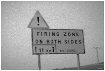
I spent five days in June this summer exploring Mount Yeroham and the region around it in the northern Negev of Israel.[1] This excursion was a great success. My desire now is to share as much of my experience with you, my readers and friends, as the medium of writing may permit.

This goal cannot be accomplished in a single issue. In the present article I focus on the foundational issue of how we can be confident Mount Yeroham is the true Mount Sinai. In future issues I hope to report on the excursion itself, including many photographs which were taken while at Yeroham. I am also hoping, before too many months have passed, to make more of this experience available on video, from footage filmed on site.

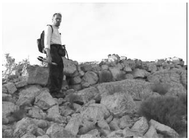
The total personnel for this excursion consisted of myself, Dr. Gerald E. Aardsma, and my cameraman, Philip Gioga (pronounced Joy-a). Philip is a friend of the family of a number of years and a college student in a communications program.

Introduction

I have previously proposed that Mount Yeroham is the Biblical Mount Sinai.[2] This proposal is unusual only in the sense that, to the best of my knowledge, nobody has ever proposed this specific mountain before. Many other mountains have been proposed in the past, and proponents of a variety of candidate mountains can be found at present. Bible encyclopedias will typically list several candidates and state that it is impossible to tell today which is the true Mount Sinai.

But the Bible encyclopedias are wrong. They are currently all out of date on this matter. Times have changed.

It was impossible to figure out which was the true Mount Sinai ten years ago. As we will see below, correct chronology is vital to this problem, and ten years ago everyone was using a chronology for the Bible which was wrong—badly wrong.

That all changed with the discovery in 1990 that a thousand years had accidentally been dropped from 1 Kings 6:1.[3] With that discovery many longstanding, murky problems in ancient Bible history suddenly began to clarify. And one of those problems was the identification in the modern world of the mountain upon which Moses once stood and received the Ten Commandments on tablets of stone from the hand of God.

Mount Yeroham is not just another candidate. It is the candidate one finds when one has their Biblical chronology right.

Purpose of Excursion

My main objective in visiting Yeroham was not to prove that Mount Yeroham is Mount Sinai. However, having been there has removed all objective grounds for doubting the validity of this identification. There is very much about Yeroham which corroborates its equivalence with Sinai and nothing about it that I have been able to find which falsifies this identification.

I had two main reasons for wanting to visit Mount Yeroham. First was the purely scientific motive of documenting the state of the site today. I wanted to capture as much factual information as possible about the site before its intrinsic nature becomes submerged beneath national and/or commercial interests.

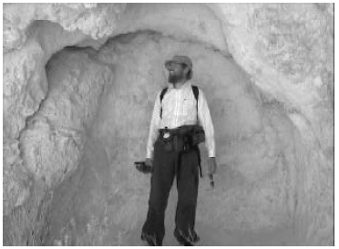
Second was a motive—not far removed from science, by any means—of curiosity. I wanted to enter into the experience of Moses and the Israelites as they camped at the foot of Mount Sinai four and a half thousand years ago. I wanted to know, first hand, what a sunrise was like at Sinai—how it must have felt to the Israelites as they rose to each new day in their tent city at the base of Sinai. I wanted to see what they would have seen: the rocks, the desert vegetation, the insects… I wanted to feel the heat they would have felt. I wanted to handle broken fragments of the pottery vessels they once carried water in, or ate their meals from. I wanted to view the form of Mount Sinai as they would have been familiar with it. I wanted to climb the mountain, as Moses would have climbed the mountain—to feel the physical exertion he would have felt laboring upward under the desert sun. I wanted to step into the bamah that Moses had built on the mountain,[4] and see the view of the Sinai plain far below, as he did. I wanted to ascend to the summit in his footsteps. I wanted to know what kind of rock the Ten Commandments had been written on. I wanted to learn whatever I could of the physical manifestations of God's presence on the mountain—the smoke, the fire, the sound of the trumpet, the thunder. I wanted to exorcize both dusty scholarly speculations and scintillating Hollywood imaginations about Sinai with a hefty dose of the real thing. I wanted to drink in as much of the brute physical reality of Sinai as was possible for any individual, these four and a half thousand years after the Israelites had been there.

I have now fulfilled these aspirations. There is much I want to pass along to you. But before I do, it seems necessary to set forth, as clearly as possible, the objective grounds upon which the identification of Yeroham with Sinai rests.

"Proof"

Science proceeds by logical induction, rather than deduction. This means that proofs of the sort one finds in mathematics are impossible in science. The basic logic of scientific discovery is to: 1. formulate a hypothesis, and then 2. proceed to test the hypothesis. The hypothesis may fail the test. In that case it has been falsified. One then discards it and tries to formulate a better hypothesis. On the other hand the hypothesis may pass the test. In that case it has been corroborated. Note immediately that corroboration is not proof. The hypothesis may fail a different test, showing that it is false after all. But the more different tests a hypothesis passes, the greater its degree of corroboration, and the greater our confidence grows that it is a valid statement about reality.

The hypothesis of interest in the present case is: Mount Yeroham is the Biblical Mount Sinai. A set of seven basic tests plus two site-specific tests of this hypothesis leading to confidence in its validity are summarized below.

Test 1

Mount Sinai is depicted in the Bible as a mountain. If Mount Yeroham is the Biblical Mount Sinai then Mount Yeroham must be a mountain.

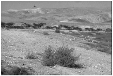
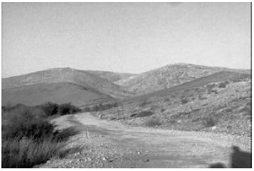
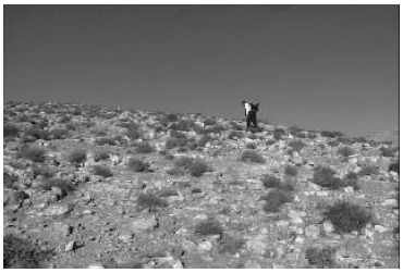
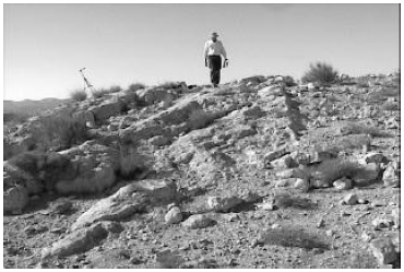
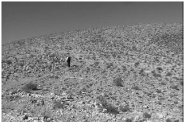
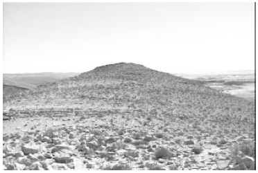
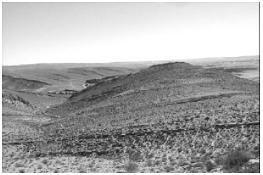
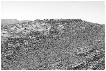
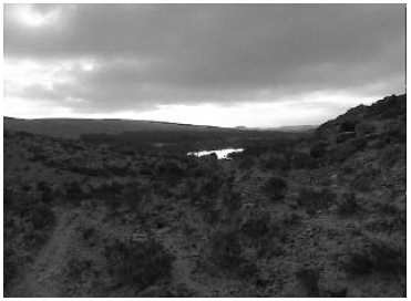
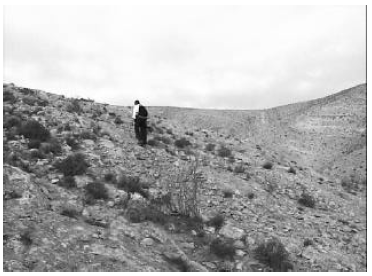
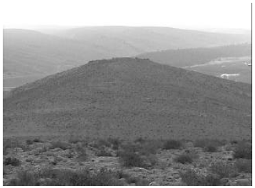
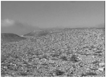
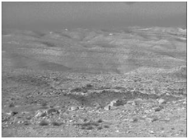
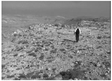
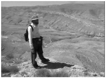
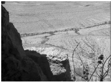
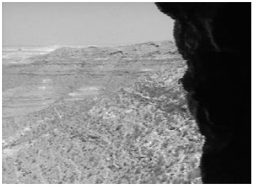
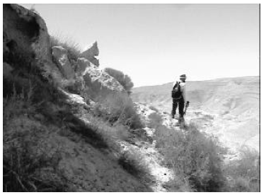
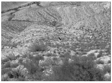
Mount Yeroham is, as its name implies (and as I can now verify from my own first-hand experience), a mountain. It is not a very tall mountain, as far as mountains go. It is a low, sprawling mountain (Figures 1 and 2). Its summit is only 2,156 feet above sea level, and only 580 feet above the wadi bed at its base. The Empire State Building rises roughly two and a half times higher above ground level than Mount Yeroham does. But Mount Yeroham is certainly much more than a hill—it is a low mountain. Mount Yeroham passes this test.

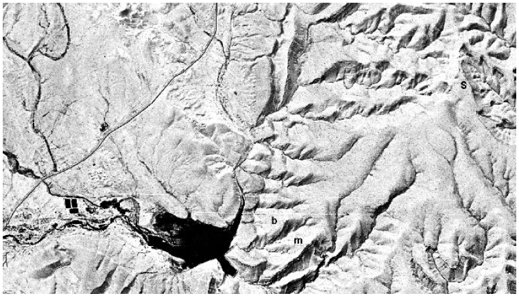
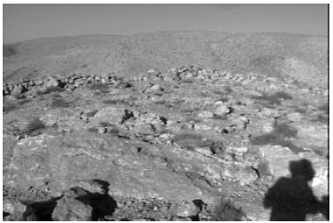
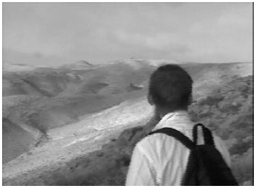
Figure 1: Distant view of Mount Yeroham from the shoulder of another mountain to the northeast. A corner of the plain intervenes, including a part of the reservoir, explaining the strip of vegetation. Yeroham is a low-lying, sprawling mountain, part of a chain of mountains bordering the northwest side of the Yeroham plain. The ascent to the summit (left arrow) from the bamah (right arrow) is a gentle slope, rising roughly 320 feet over the one and a quarter mile distance between the two. The line of sight distance to the summit from the camera in this photo is about two and a half miles.

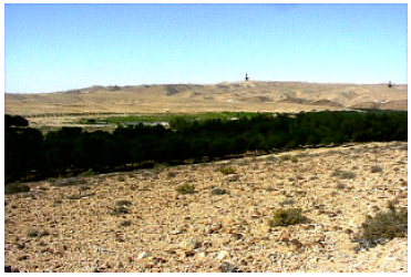
Figure 2: Satellite photo of Mount Yeroham (right half of photo) and a small portion the Yeroham basin (left half of photo) where the Israelite encampment was situated. The large dark object is a modern reservoir. The present summit is marked by "S", the bamah by "b", and the "main settlement" by "m". North is toward the bottom in this view. [Photo taken September 29, 1971; available from U.S. Geological Survey EROS Data Center as DS1115-2300DF053.]

Test 2

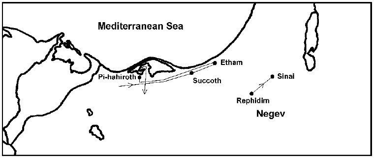
The Bible teaches us that Mount Sinai is located outside the borders of Egypt, to the east, but not a very great distance outside Egypt. The Israelites arrived at Mount Sinai forty-five days after they had left Egypt.[5] God used the first portion of their journey to bait hard-hearted Pharaoh into the Red Sea trap. At least a week must have passed by the time that was over, and when it was through they were left back nearly at the border of Egypt again.[6] They camped at other sites for much of the remaining part of those forty-five days. They launched a major battle with the Amalekites at Rephidim, one of their encampment sites, which implies a protracted stay there.[7] So one should probably picture Sinai as, at the very most, a three week journey outside of Egypt.

This leads to the expectation that the path to Sinai from Egypt must be less than 630 miles long. This figure is what one gets assuming three weeks of traveling at 30 miles per day—a reasonable rate for people on foot with sheep and cattle.

Thus, if Mount Yeroham is the Biblical Mount Sinai then Mount Yeroham must be located not more than 630 miles from Egypt.

In fact, Mount Yeroham is located roughly 150 miles from Egypt. Mount Yeroham passes Test 2.

Test 3

Mount Sinai is not located in Midian. This is demonstrated, for example, by Numbers 10:29–32, which records a dialog between Moses and his brother-in-law, Hobab, as the Israelites were about to leave Sinai.

Then Moses said to Hobab the son of Reuel the Midianite, Moses' father-in-law, "We are setting out to the place of which the Lord said, 'I will give it to you'; come with us and we will do you good, for the Lord has promised good concerning Israel." But he said to him, "I will not come, but rather will go to my own land and relatives." (Numbers 10:29–31, NASB)
Hobab said he would go to his own land and relatives upon leaving Sinai. His own land—the land where his father-in-law lived—was Midian. This makes it clear that Mount Sinai was not anywhere in the land of Midian.

Thus, if Mount Yeroham is the Biblical Mount Sinai then Mount Yeroham must not be located in Midian.

In fact, Mount Yeroham is located in the Negev of Israel, not Midian. Mount Yeroham passes Test 3.

Test 4

We learn from the Bible that there was a desert wilderness in front of Mount Sinai.[8] This wilderness was somehow distinct from its surroundings since the Israelites "came into" it.[9] The Israelites camped in this wilderness.[10] About 600,000 men were present in this camp.[11] Thus, the wilderness had to be large enough to accommodate hundreds of thousands of tents.

We can estimate the size of this wilderness by assuming a ten foot by ten foot (100 square feet) camping area for each man. (This is meant to include space for women and children and also space for pathways between the tents.) This figures to 1,377 acres.

Putting this all together: if Mount Yeroham is the Biblical Mount Sinai then there must be a geographically distinct wilderness in front of the mountain suitable for erecting a tent city covering something like 1,400 acres.

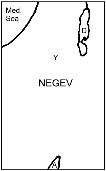
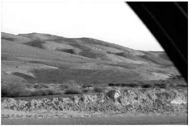
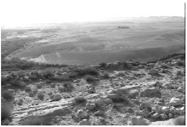
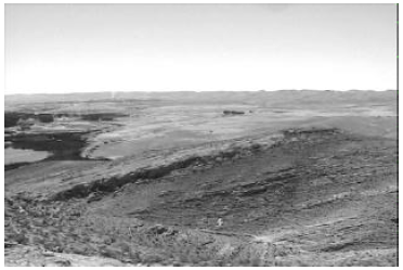
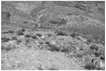
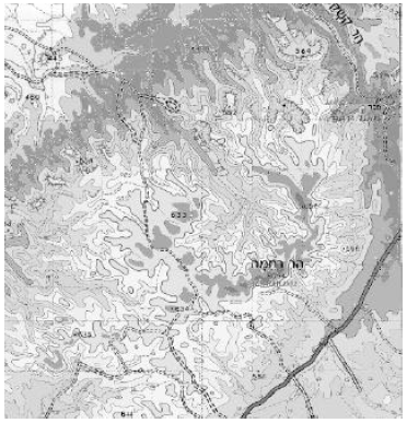
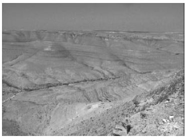
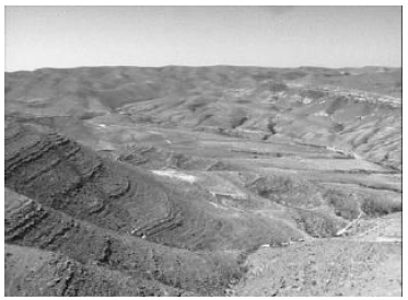
There is a very large, elongated desert plain at the base of Mount Yeroham (Figure 3). Its long axis runs northwest/southeast. It is bordered by northwest/southeast trending mountain ranges. The Yeroham Basin—the region which is drained by wadis emptying into the Yeroham reservoir at the foot of Mount Yeroham—is roughly 15 kilometers long by 7 kilometers wide. The width of this drainage area includes foothills and parts of mountains. The total width of the plain portion of this basin—the area suitable for erecting tents—is roughly 3 or 4 kilometers. A width of 3 kilometers yields a plain area of 2,965 acres. This is over a factor of two larger than the requirement computed above. The hypothesis that Mount Yeroham is the Biblical Mount Sinai passes Test 4.

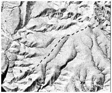
Figure 3: Topographical map of the region around Yeroham. The drawn black oval shows the approximate limits of Mount Yeroham. The drawn black lines show the approximate limits of the portion of the plain, suitable for tents, which drains into the reservoir at the base of Mount Yeroham. (Figure constructed using Survey of Israel topographical maps published in 1991 and 1992. The small grid squares are one kilometer on a side.)
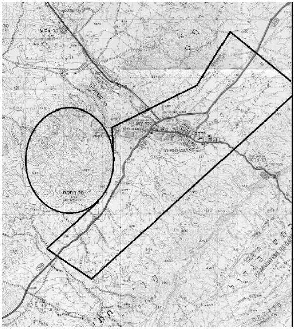
Test 5

The plain in front of Mount Sinai should be found to be littered with pottery shards today.

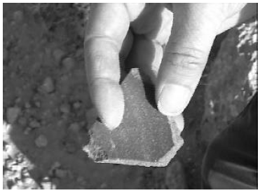
Archaeological sites are most easily and frequently discovered by pottery fragments lying on the ground. This results from the facts that: 1. pottery shards are of no intrinsic utility, so they tend to remain where they were originally discarded, and 2. pottery shards are very durable.

The Israelites camped at Sinai for one year. There were roughly two million Israelites camped there that year, counting women and children as well as the men. If two million Americans camped somewhere for one year, we would expect to find the ground of their campsite littered with soda cans and other garbage when they left. Similarly, the ground where the Israelites camped at Sinai would be littered with pottery shards when they left. Thus, if Mount Yeroham is the Biblical Mount Sinai, then the plain in front of the mountain should be found to be littered with pottery shards today.

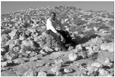
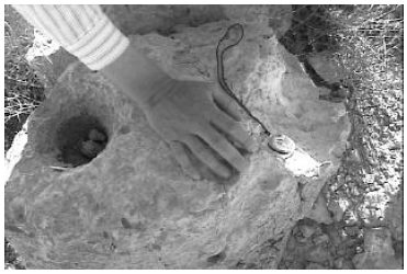
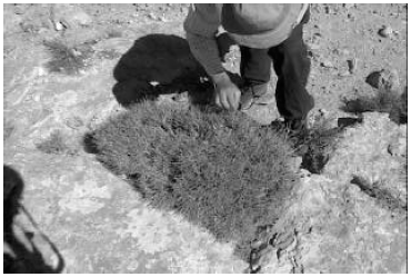
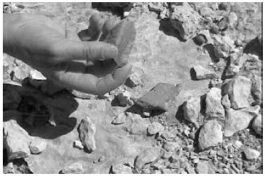
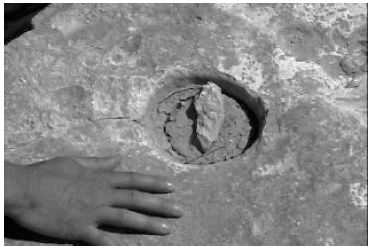
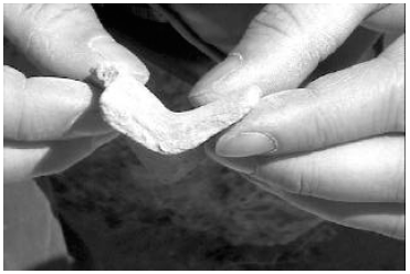
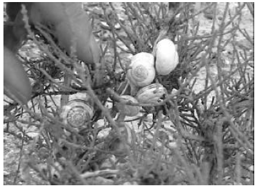
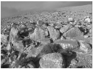
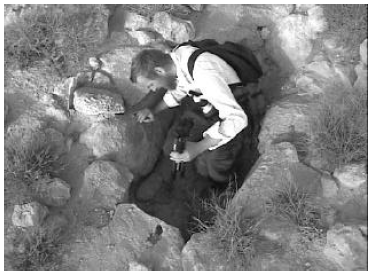
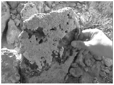
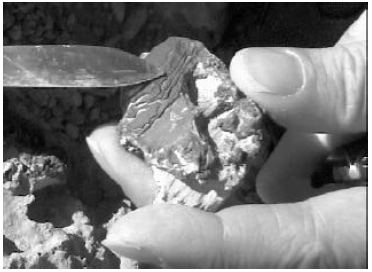
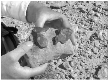
The archaeologists report that the plain at the foot of Mount Yeroham is littered with pottery shards. It is, in fact, these pottery shards which define the extent of the archaeological site at Yeroham. Philip and I walked back and forth across several acres of the plain at the foot of the mountain one morning to get a feel for the density of pottery shards in the area. We walked beside each other, several yards apart, in straight lines, calling out "piece" every time we spied a pottery shard. Intervals of silence were few and of relatively short duration—there was broken pottery everywhere. (See Figures 4 and 5.) The plain is indeed littered with pottery shards. Mount Yeroham passes Test 5.

Figure 4: Pottery shards on the Yeroham plain photographed in June, 2000. In the upper photo, shards from an area of several square yards have been collected together. In the lower photo I am holding a piece I have just picked up.

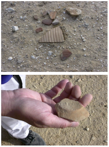
Figure 5: More pottery shards from the Yeroham plain.
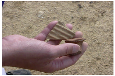
Test 6

There must be a source of water at Mount Sinai capable of supplying the needs of several million people year round. This follows from the fact that there were several million Israelites at Sinai and they camped there for a year. While Moses brought water from the rock at Rephidim,[12] the encampment sight prior to Sinai, no such arrangement was necessary at Sinai. This implies that Sinai had a natural, abundant source of water. If Mount Yeroham is the Biblical Mount Sinai, then Yeroham must have a natural, abundant source of water.

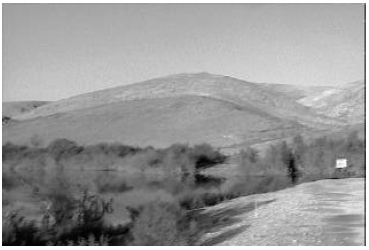
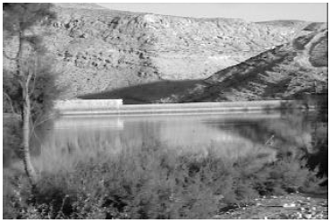
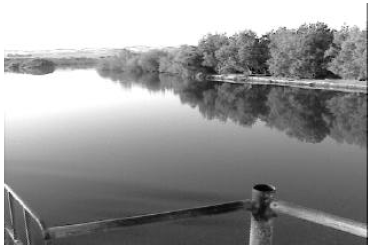
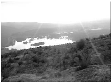
Yeroham does have a natural, abundant source of water. This is most clearly seen by the large reservoir at the foot of the mountain today (Figure 2). This reservoir was not as large at the time of Moses as it is today. The water from the entire drainage basin is presently impounded by a large modern dam. But the existence of this large modern dam serves to demonstrate that water is naturally abundantly available in this unique desert location. In addition to the reservoir, a well, shown on maps as "Be'er Yeroham", exists at Yeroham. The ready availability of abundant water year round at Yeroham is perhaps most clearly demonstrated by the existence of the large modern town called Yeroham on the plain a few miles from the mountain today (Figure 3). Mount Yeroham passes Test 6.

Test 7

Now here is the acid test. The archaeological remains at Mount Sinai must date to the time of the Exodus. The Bible informs us that Israel was at Sinai just forty-five days following the Exodus, as noted above.

The Exodus happened roughly 2450 B.C. according to modern Biblical chronology.[13] The only physical dating method which might provide us with a calendar date for the remains at Yeroham is radiocarbon. Unfortunately, there are, so far, no radiocarbon dates from Yeroham.

Fortunately, however, it is not necessary to obtain a calendar date to perform this test. It is possible to use the style of pottery found littering the plain at Yeroham to check whether the archaeological remains at Yeroham date to the time of the Exodus.

I have previously shown—long before I heard of Yeroham—that the Exodus was the cause of the collapse of the Old Kingdom in Egypt.[14] I have also previously shown that the Conquest was the cause of the collapse of the Early Bronze III urban civilization in Palestine.[15] (See Figure 7 in the "Biblical Chronology 101" section this issue for a time chart with the archaeological time periods mentioned here.) Early Bronze III in Palestine was followed by Early Bronze IV (also called Intermediate Bronze and also, confusingly, Middle Bronze I by various archaeologists). Early Bronze IV is the period of the judges of Israel recorded in the Biblical book of Judges. The Early Bronze IV people are the Israelites. Thus, Early Bronze IV pottery is Israelite pottery.

Putting this all together, the Israelites should have been carrying a mixture of their own pottery (i.e., pottery made by their own craftsmen) and some Egyptian pottery when they came out of Egypt at the time of the Exodus. The Egyptian pottery should have been of the style used at the end of the Old Kingdom (i.e., Dynasty Six) and beginning of the First Intermediate Period, which is when the Exodus happened. Their own pottery should have been the earliest type of Early Bronze IV pottery, since the Israelites were the bearers of the Early Bronze IV culture, and this culture was first seen outside Egypt immediately following the Exodus.

Thus, if Mount Yeroham is the Biblical Mount Sinai then the pottery found ubiquitously at Yeroham should be of the style associated with the end of the Old Kingdom in Egypt and the beginning of the Early Bronze IV in Palestine.

This is exactly what is found. Even though I have looked at and handled much pottery at the base of Mount Yeroham I do not assert this on the basis of personal experience—I am untrained in the science of pottery dating. The appraisal of professional archaeologists who have conducted excavations at Yeroham, such as Moshe Kochavi in this next quote, are obviously of much greater weight:[16]

The ceramic [pottery] finds are typical of the Intermediate Bronze Age (Middle Bronze Age I) [our Early Bronze Age IV]…

Another two archaeologists, Eliezer Oren and Yuval Yekutieli, give more specific dates for the ceramics found at Yeroham. Their appraisal is that ceramics of this sort date:[17]

to the beginning of the Middle Bronze I period [our Early Bronze IV], i.e., to the period of time that in Egypt coincides with the end of the Sixth Dynasty [i.e., end of the Old Kingdom] and the beginning of the First Intermediate Period …
This is precisely the right date—the hypothesis that Mount Yeroham is the Biblical Mount Sinai passes Test 7.

Other Candidates

The preceding seven tests constitute a basic set of tests which any candidate for Mount Sinai must pass. Mount Yeroham is the only site I know of which passes these seven tests. A few examples may help to illustrate this point.

Jebel Serbal

Eusebius [3rd-4th century A.D.] stated that Jebel Serbal (6,691 feet high), S of the Wadi Feiran…, was the mount of lawgiving. The valley, however, is narrow with no plain in the vicinity large enough for the year-long encampment of the 12 tribes of Israel.[18]
Thus, the hypothesis that Jebel Serbal is Mount Sinai is falsified by Test 4. (It is also falsified by other of this set of seven tests, but one falsification is sufficient to invalidate a hypothesis—once a hypothesis has been falsified by one test there is no need to investigate it any further.)


Jebel Musa, Jebel Katarin, or Ras es-Safsafeh

The second tradition, going back to the time of Justinian (6th cen. A.D.), identifies Mount Sinai with Jebel Musa ( c. 7,500 feet high). It is one of a cluster of three peaks, Jebel Katarin ( c. 8,600 feet), lying about two miles to the SW, and Ras es-Safsafeh (6,540 feet), equidistant to the NNW. At the foot of the latter peak to the N is the only broad plain in the vicinity; it is called er-Raha, about two miles long and a half mile wide, spacious enough for the tents of all Israel.[19]

Since only Ras es-Safsafeh has a plain at its base "spacious enough for the tents of all Israel" both the hypothesis that Jebel Musa is Mount Sinai and the hypothesis that Jebel Katarin is Mount Sinai are falsified by Test 4.

But note that Ras es-Safsafeh does not do well relative to Test 4 either. A plain measuring two miles by half a mile, as er-Raha is reported to be in the quote above, is only 640 acres. This is less than half the 1,400 acres needed to accommodate the Israelites as calculated in Test 4 above. This suggests that er-Raha is very likely not "spacious enough for the tents of all Israel". But let us move on to other tests with this candidate, so as not to seem to be quibbling.

I have no data or first-hand evidence on the pottery shard density in er-Raha, so I am unable to apply Test 5 to the Ras es-Safsafeh candidacy. But I am able to apply Test 7 through the published assertion of professional Israeli archaeologist, Ram Gophna, that:[20]

no Intermediate Bronze Age [our Early Bronze IV] sites were discovered in the mountains of southern Sinai.
Test 6 requires that there be a very large Intermediate Bronze Age (Early Bronze IV) site on the plain at the foot of Mount Sinai. Since there are "no Intermediate Bronze Age sites… in the mountains of southern Sinai", where Ras es-Safsafeh is situated, the hypothesis that Ras es-Safsafeh is Mount Sinai is falsified.


Mount Karkom

Archaeologist Emmanuel Anati has advanced Mount Karkom as the Biblical Mount Sinai.[21] Unfortunately, many details about the site, of importance in the present context, including its extent and chronology, are not clear, at least in The New Encyclopaedia of Archaeological Excavations in the Holy Land article by Anati on it. But there is one important fact which does seem clear enough.

Like Mount Yeroham, Mount Karkom is located in the Negev desert. However, while Mount Yeroham is located in the northern Negev, which receives roughly six inches of rainfall annually, Mount Karkom is located in the southern Negev, which receives only about two inches of rainfall annually.[22]

This immediately raises an obvious concern with this candidate—water. There is no abundant, year-round source of water at Mount Karkom. The nearest source of water today appears to be a well, Be'er Karkom, about four miles north of the mountain.

I have no data on the capacity of this well, but I would note that from the perspective of accessibility alone, an open pool seems much more likely as a water source for the Israelites than a well. To supply the needs of two million people the water source must be able to furnish enough water to meet the needs of twenty-three people each second, day and night. This does not include water for the animals. Two quarts per person per day seems a reasonable estimate of the minimum volume of water needed. This equates to a flow rate of eleven gallons of water per second, or 690 gallons per minute—about the output of 100 outdoor lawn or garden faucets running at full flow twenty-four hours per day. The well must not only be able to source this much water year round, there must also be some way of lifting the eleven gallons—ninety-six pounds—out of the well each second. A single well seems seriously inadequate to the Israelite's needs.

In addition, a topographical map of the region shows that this well would have been quite a distance from the Israelites had they camped there. The only plain, of suitable size for the tent city of the Israelites, is located to the southwest of the mountain. The distance from this plain to the well is about five miles minimum and nine miles maximum. This means that the Israelites would have needed to make a five to nine mile hike, one way, to draw water for livestock and domestic use. This would have consumed a significant fraction of each day.

I judge that Mount Karkom lacks an adequate water supply for the Israelites. Test 6 falsifies Mount Karkom.

Jabal al Lawz

One final candidate which is currently being promoted vigorously in some lay Christian circles is Jabal al Lawz, in Saudi Arabia.[23] This candidate is falsified by Test 3; it is located within ancient Midian, as I have previously pointed out.[24]

Further Tests of Mount Yeroham

Having strongly corroborated the hypothesis that Mount Yeroham is the Biblical Mount Sinai through the basic set of seven tests described above, it is possible to submit it to further, site-specific tests. The idea behind each of these tests is to ask whether anything about the Yeroham site is unsuitable in any way to the Biblical record regarding Sinai.

Having now spent five days at Yeroham I am able to report that I, at least, can find nothing about the site which contradicts the Biblical account in any way. I find that Yeroham fits the Biblical record of Sinai naturally and with ease. A brief illustration of this point with respect to the two most conspicuous archaeological assemblages at Yeroham follows.

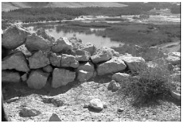
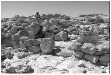
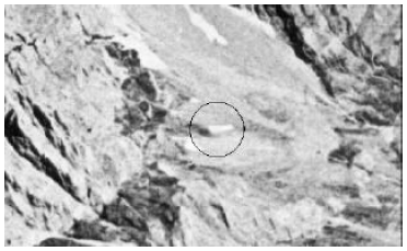
The Bamah at Yeroham

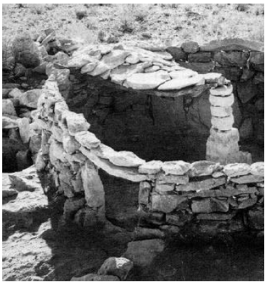
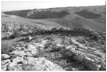
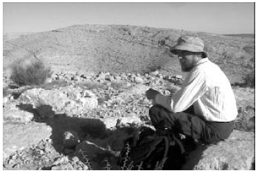
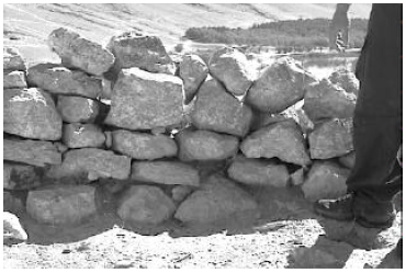
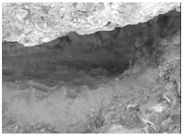
I have previously discussed the bamah, or high place, which is found on a spur of Mount Yeroham overlooking the plain.[25] All that remains of this high place today is a rock wall surrounding the crest of the spur, and some cupmarks in the bedrock surface which outcrops within the ring of stones. If Mount Yeroham is the Biblical Mount Sinai then there must be nothing about this bamah which contradicts the Biblical record.

I can now testify first hand that the bamah does not contradict the Biblical record; in fact, the bamah is strongly supportive of the picture of Sinai the Bible paints. Exodus 24:4 (NASB) records, "Then he [Moses] arose early in the morning, and built an altar at the foot of the mountain [Mount Sinai] with twelve pillars for the twelve tribes of Israel". The bamah at Yeroham suits Exodus 24:4 very well. It is appropriately situated "at the foot of the mountain". It is also suitably situated for the sealing-of-the-covenant ceremony which Exodus 24 records was enacted at Moses' altar. Moses acted as mediator between God and the people in this covenant ceremony. The high place at Yeroham is up high enough to overlook the entire plain below, where the people were camped. Yet it is well below the summit of the mountain, where the glory of the Lord appeared "like a consuming fire on the mountain top" (Exodus 24:17, NASB). Thus, it was suitably located on middle ground, between God and the people.

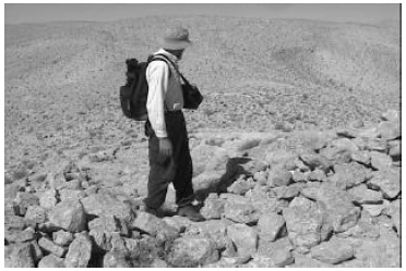
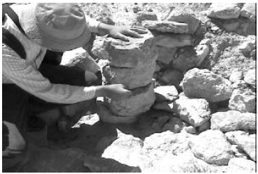
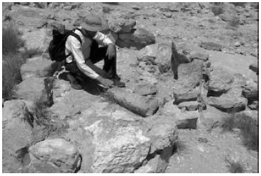
The "Main Settlement" at Yeroham

The only domestic structures found at Yeroham by the archaeologists are remains of dry-laid stone buildings located on another spur of the mountain to the north of the bamah (Figure 2). The archaeologists have called this collection of buildings the "main settlement". They have excavated a portion of these buildings and found characteristic Early Bronze IV pottery there, like the pottery found on the plain. They uncovered two strata at the site. This is, apparently, the only case having buildings of this sort in this time period in which more than one stratum has been found. Buried in the remains of one of the dwellings of the upper stratum,

a hoard of eighteen copper ingots with low lead content was found. These suggest the existence of a metal industry…[26]

If Mount Yeroham is the Biblical Mount Sinai then there must be nothing about these "main settlement" remains which contradicts the Biblical record.

Here again, far from contradicting the Biblical record, everything about the "main settlement" seems to harmonize immediately with the Biblical account of the Israelites' stay at Sinai.

The existence of the "main settlement" buildings, distinct in construction and location from the Israelite tent city on the plain below the mountain, finds explanation in the Biblical record of the presence of Moses' Midianite relatives, an ethnic group distinct from the Israelites, at Sinai. We learn from the Bible that they were not under Moses' leadership. This is shown by Hobab's statement that he would return to his land and his relatives, quoted above, and by Moses' request, rather than command, that Hobab remain with them.[27] Thus it is not surprising to find them situated on a spur of their own, away from the Israelite camp.

The evidence of a copper industry within the Midianite village at Yeroham also fits the Biblical record. Jethro, Moses father-in-law, is described in Judges 1:16 as a Kenite. "Kenite" means metal smith:[28]

The term "Kenite" comes from qayin, which originally meant "metalworker, smith," as in Aram. and Arabic. … The Kenites apparently were nomadic or seminomadic clans of smiths…
Thus Moses' in-laws were metal-working, Midianite nomads.

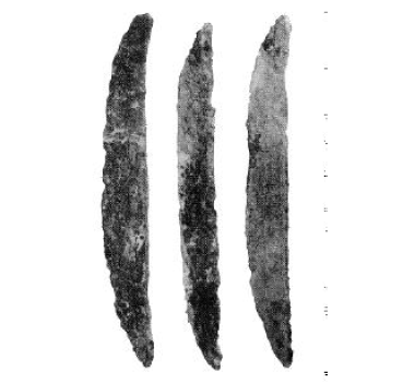
With this in mind we can begin to understand Moses' in-laws interest in the Israelites at Sinai. Here were hundreds of thousands of former slaves equipping for the conquest of Canaan. Typical weapons of the Early Bronze IV period (i.e., Israelite weapons following the Exodus) are shown in Figure 6.[29] These were made of copper, or copper alloyed with a small percentage of arsenic (arsenic bronze). Clearly, the Midianite presence at Sinai benefited both the Israelites, who needed weapons, and the Midianites, who made their living, in part, by crafting copper.

Figure 6: Typical weapons of the Early Bronze IV period in Palestine. On the left are javelin heads and butts. They were fastened to the shaft by splitting the wood, inserting the tang, bending the end of the tang around the stick, then binding the split with twine or copper wire. On the right, at the top, is a fenestrated axe head. These were cast in a mold in one piece. A socket runs along the spine for inserting a wooden handle. Below the axe are two daggers. These were riveted to hafts. The basic metal in all instances is copper. Since the Early Bronze IV period lasted more than four centuries, one should not assume that all of these weapon types were present at Sinai. The fenestrated axe, for example, may only have been introduced part way through the Early Bronze IV period. [See text for reference to original photo.]

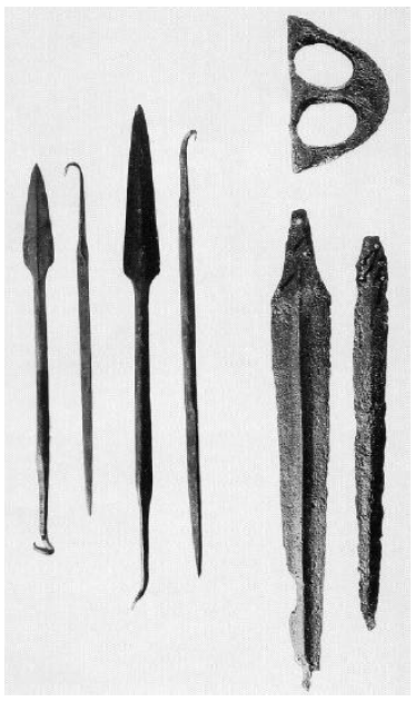
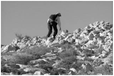
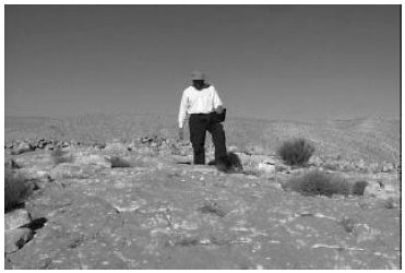
The style and situation of the "main settlement" dwellings excavated by the archaeologists at Yeroham also harmonize immediately with what we learn of the Midianite/Kenites from the Bible. Numbers 24:21 (NASB) says of the Kenites, "Your dwelling place is enduring, and your nest is set in the cliff". I have now been to Yeroham and spent part of a day walking around in these "main settlement" dwellings. I can testify that "nest" is an apt description of these buildings, and that they are indeed "set in the cliff". At one point I had to caution Philip not to step backwards while filming these buildings, for fear of losing him into the ravine below.

Another puzzle piece which fits immediately with the Biblical picture is that of the existence of two strata within the "main settlement". An explanation of this apparently unique occurrence at Yeroham is afforded by the Biblical record of a severe earthquake at the mountain while the Israelites were camped there.[30] This raises the possibility that the lower stratum may be from the period of time before the earthquake—that the lower stratum buildings were destroyed by the earthquake—and that the upper stratum represents buildings and structures built above the ruins of the original settlement following the earthquake.

Conclusion

The true site of Mount Sinai has been a source of speculation for most, if not all, of the Christian era. Given the very large number of mountains in the deserts to the east of Egypt it is little wonder that past speculations have failed to reveal the correct mountain.

But the era of uncontrolled speculation has now passed away. Modern techniques of accurately mapping large areas, coupled with extensive archaeological surveys of the Sinai peninsula and the Negev of Israel carried out within the past three or four decades, have provided scholar and layperson alike with a wealth of easily accessible, factual data about these regions for the first time in history. These factual data, when coupled with modern results from the field of Biblical chronology, rapidly eliminate all but one candidate, including several of ancient acclaim.

The lone surviver is Mount Yeroham—the true Mount Sinai, found at long last. ◇

Biblical Chronology 101

I presented the following talk at the 17th International Radiocarbon Conference in Israel in June. I have included it this issue in this column for two reasons. First, it serves as a helpful overview and review of material covered in greater depth and detail previously in The Biblical Chronologist. Second, many subscribers have closely followed the work it describes and some have actively participated in its support. It seems appropriate that they should share in what was said.

The conference lasted one week and was attended by hundreds of scientists from around the world. Session topics included calibration of the radiocarbon time scale, radiocarbon instrumentation, the application of radiocarbon and other cosmogenic isotopes to the modern environment, archaeology, Near East chronology (the session in which the following talk was presented), global climate, and others.

My presentation was titled "New Radiocarbon Dates for the Reed Mat from the Cave of the Treasure, Israel".


Most of what I have to say today is shown on this time chart (Figure 7).

Figure 7: Main time chart presented at the 17th International Radiocarbon Conference. (The radiocarbon sample number key in the fourth column is as follows: 1. I-285, 2. BM-140, 3. WR-1341, 4. ARP-201a, 5. ARP-201b, 6. ARP-212, 7. ARP-213a, 8. ARP-213b.)

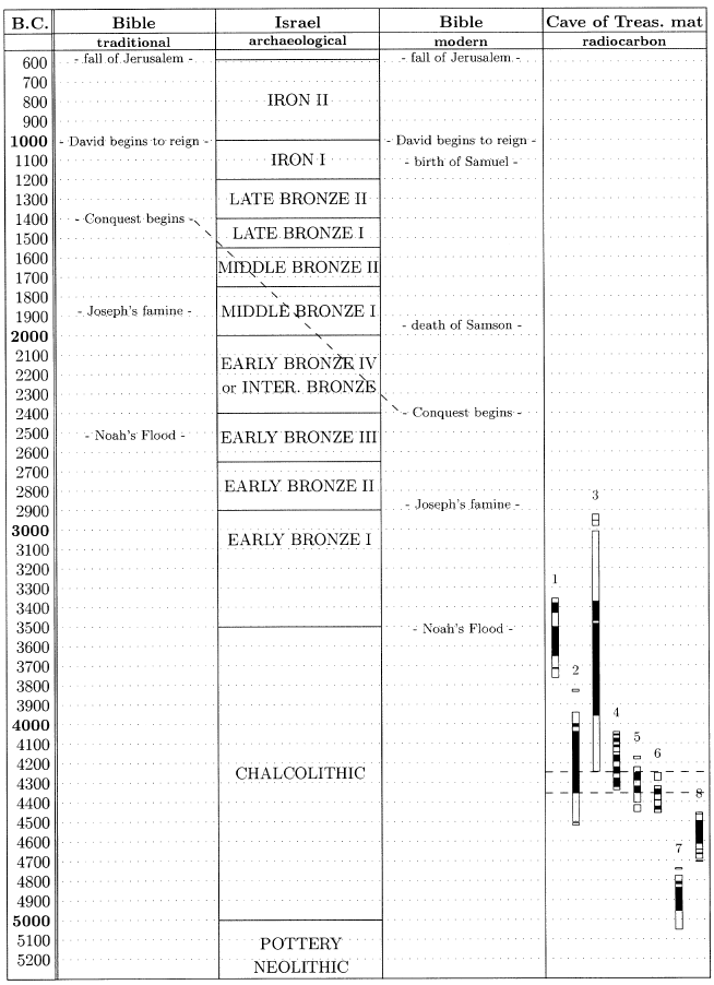
My background is in physics, with a Ph.D. in A.M.S. [Accelerator Mass Spectrometry—a technique which uses nuclear physics instrumentation to radiocarbon date extremely small samples.] from the University of Toronto back in the early eighties. But my absorbing interest for decades has been Biblical chronology.

Biblical chronology seems to me to be the one independent dating method which is being largely neglected at the present time. It had a very prominent place some few generations ago, but it did not do very well, and it is being basically ignored at the present time.

It's through this interest in Biblical chronology that I became involved in redating the Cave of the Treasure mat. I want to explain a little bit of how this has come about, and then go into some of the new dates on the mat.

What I've shown in this time chart (Figure 7) is a typical traditional Biblical chronology along side a typical chronology of the archaeology of Israel. These are both just typical—as I read various scholars in these fields I find that there is quite a lot of variation, not only in the boundaries of the different time periods, but also even in the naming conventions used for them. But the chronologies shown here are typical, and should be sufficient to illustrate what I'm trying to say here this morning.

A typical traditional Biblical chronology looks like this: it has the fall of Jerusalem just after 600 B.C., the Conquest of Canaan by the Israelites around 1400 B.C., Joseph's famine around 1900 B.C., and Noah's Flood around 2500 B.C. I've specifically chosen these five events, from quite a range of possible events that could be chosen from the Biblical narrative, because each of these five events has the property of being archaeologically detectable. The fall of Jerusalem should certainly yield archaeologically detectable results. The origin of the monarchy should also be detectable archaeologically. The Conquest is pictured Biblically as the destruction of an urban civilization—the Canaanite civilization—and the overrunning of the land by a tribally organized, pastoral, nomadic people—the Biblical Israelites. It certainly should be seen archaeologically if it is real. Joseph's famine is depicted as a very severe seven-year famine which totally impoverished countries around Egypt, according to the Biblical narrative. It should be able to be detected archaeologically if it happened. And Noah's Flood, of course, is depicted Biblically as a Flood event which wiped out the population almost entirely, with only a few survivors. It should certainly be detectable archaeologically.

If we ask how this traditional Biblical chronology has worked out relative to the reconstruction of history that comes out of archaeology, the answer is somewhat mixed.

Back nearly to 1000 B.C. there is generally good agreement.

As you know, there is a debate going on right now, near 1000 B.C., about the historicity of Solomon and David.

Prior to 1000 B.C. there is no agreement at all anywhere: certainly it's the case that nothing suitable to the Conquest happens anywhere in the Late Bronze Age; there is no famine of the right sort during Middle Bronze I; and certainly there is no Flood in Early Bronze III—it is ludicrous to suppose that any kind of major decimation of population could have happened anywhere in the Early Bronze III.

This track record of total lack of agreement prior to 1000 B.C. has led to a general consensus among scholars that the history of the Bible in this period of time is simply not valid—that it is mythological, fabricated, or whatever.

I disagree with this consensus. I find that it is not the history of the Bible which is not valid, but the chronology which is messed up, and it is messed up in a very major way.

The chronology of the Bible between the time of Solomon and the Exodus depends entirely upon one number in one verse—1 Kings 6:1. That verse says that there was 480 years between the Exodus and the building of the temple in Solomon's fourth year.

I feel that sane reasoning cannot help but conclude that the number, "480", was originally "1,480".

How the hypothesized "1,480" came to be "480" is shown on the back of the handout I gave you (Figure 8). 1 Kings 6:1 reads today as shown here (bottom of Figure 8): "Now it came about in the four hundred and eightieth year after the sons of Israel came out of the land of Egypt, in the fourth year of Solomon's reign over Israel…" that Solomon began to build the temple. In Hebrew it looks as shown here (bottom line of Hebrew in Figure 8): "And it was – in the eightieth – year – and four – hundred – year – from the exodus…" It seems impossible to conclude otherwise than that the Hebrew originally had a "thousand" years in here (top line of Hebrew in Figure 8): "And it was – in the eightieth – year – and thousand – and four – hundred – year – from the exodus…", and that in the process of copying this verse some long time ago the scribe accidentally skipped over from these two characters to where they are repeated, leaving out this thousand years.

Figure 8: How a "thousand" years came to be dropped from Biblical chronology.

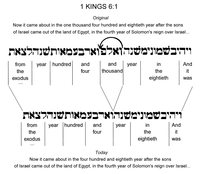
This is a minor copy error. Copy errors of this sort can be unambiguously demonstrated from various extant Old Testament manuscripts.

It is a very tiny copy error, but it has resulted in a very major chronological error in Biblical chronology, which has not been recognized traditionally.

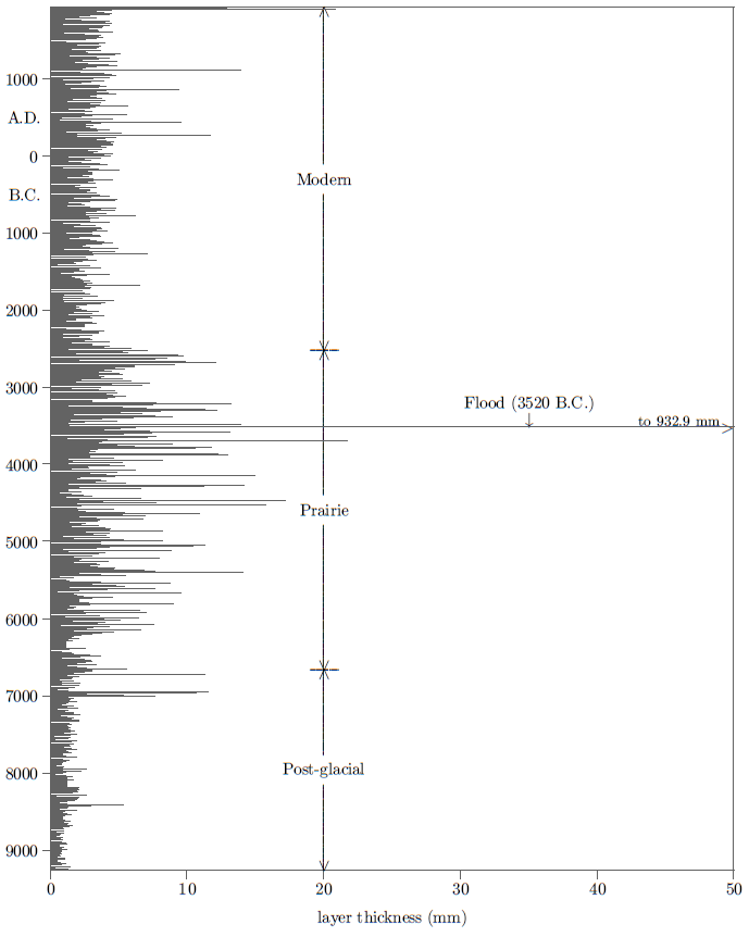
If you put this missing thousand years back into the chronology, which is what I've done here, in this column (third column of Figure 7)—I have simply added in the additional thousand years, which moves the Conquest down near 2400 B.C., Joseph's famine down near 2900 B.C., and Noah's Flood down near 3500 B.C.—it totally changes the outlook for the historicity of these Biblical events.

The Conquest, for example, does find a natural setting near 2400 B.C. in Biblical archaeology and secular history. We're expecting to find, from the Bible, at the Conquest, the destruction of an urban Canaanite civilization in Palestine. The Early Bronze III civilization is an urban civilization. The Early Bronze IV, or Intermediate Bronze, results from the destruction of that urban civilization everywhere in the land, and its replacement by a tribally organized, pastoral, nomadic people. This "thousand years" correction says that the Intermediate Bronze people are the Biblical Israelites.

Joseph's famine also moves one thousand years earlier than traditional expectations. Here again, at the earlier date, a natural match to the archaeological record is found. The transition shown here between Early Bronze I and Early Bronze II is the one at which all the sites of the Early Bronze shrink in size. Megiddo, for example, shrinks from 160 acres down to something like 13 acres at this time. The population of Megiddo shrinks from 9,000 down to 900 or 1,000. This shrinkage of the Early Bronze population is seen throughout the land. This is the only geographically extended transition of any sort in Early Bronze I through Early Bronze III that I've been able to find, reading what the archaeologists have to say about it. It is at the same time—within the dating uncertainties that are involved here—as Joseph's famine.

Most shockingly—it took me five years to come to see this after having found that a "thousand" years had gotten dropped out of the Biblical text—even the Flood finds a natural setting archaeologically when moved back one thousand years earlier than traditional expectations.

I'm sure those who are archaeologists here know that the transition between the Chalcolithic and the early Bronze is unique in that it appears that the Chalcolithic people, to a very large extent, vanished at the end of the Chalcolithic. Civilization starts over again at the beginning of the Early Bronze. This is the fundamental requirement of Noah's flood. It is pictured Biblically as a catastrophe in which the population is nearly exterminated and only a very few people remain to start over again afterwards.

The temporal coincidence between the Biblical date of Noah's Flood, when once the missing "thousand" years are restored, and the archaeological date of the end of the Chalcolithic period in Palestine is obviously of great interest. I've spent a number of years now examining it, and asking the question, "Do we really have a synchronism between the Biblical Flood event and this transition?"

And that's how I got into redating the Cave of the Treasure's mat.

The Cave of the Treasure mat looked like it would perhaps be the best single sample to use to radiocarbon date the end of the Chalcolithic. I was hoping to refine the date of the terminal Chalcolithic by a more careful dating program on this mat.

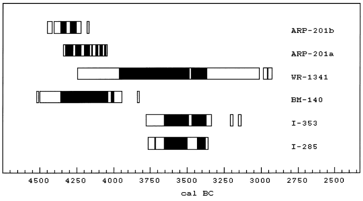
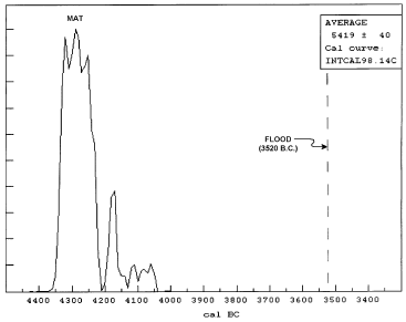
What I'm showing here (Figure 9) are radiocarbon dates that were made on the Cave of the Treasure mat, plus one date on a piece of wood that was found in association with the mat, back in the 1960's when the mat was first discovered by Pessah Bar-Adon and his archaeological team working in the Judean desert. The top three are on the mat, and this one, I-353, is on a piece of wood associated with the mat.

Figure 9: Early 1960's radiocarbon dates on the Cave of the Treasure mat and one associated piece of wood.

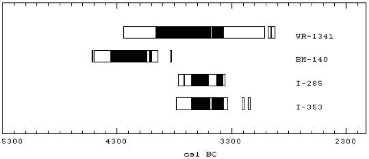
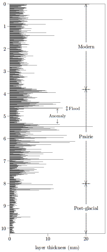
These dates appeared to be giving a reasonable indication that the Cave of the Treasure mat had originated near the end of the Chalcolithic. You can see that three of them are in harmony, near 3500 B.C., and one is an older date which appears to be an outlier.

The stratigraphy in the cave, the nature of the objects found with the mat, and several other indications all seemed to suggest that the mat had originated just prior to the close of the Chalcolithic.

So I began to seek permission to have the mat redated, and I was ultimately granted that permission by the Israel Antiquities Authority.

Unfortunately, I have been totally frustrated in my efforts to refine the date of the terminal Chalcolithic using this mat. I find, in fact, that the mat does not originate at the end of the Chalcolithic at all.

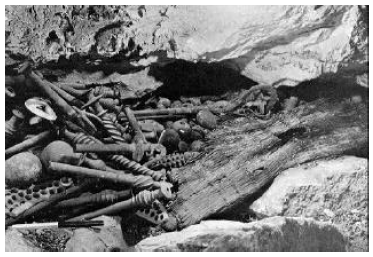
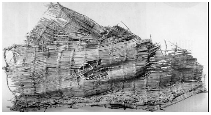
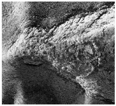
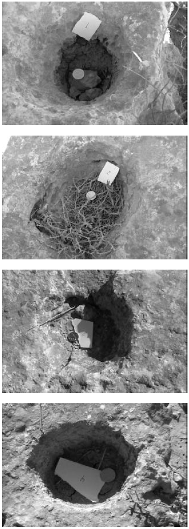
Figure 10: The Cave of the Treasure mat. White circles show areas where samples have been taken for modern radiocarbon dates.

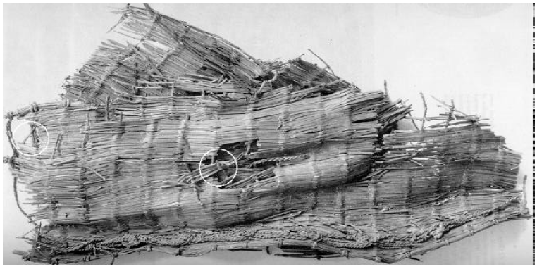
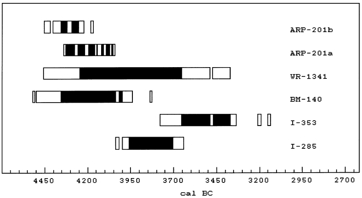
The fourth column (Figure 7) shows the three 1960's radiocarbon dates on the mat together with five new radiocarbon dates on the mat. The two dates, 4 and 5, are sister samples, and they show good agreement. (We're using CALIB 4 here for these date ranges; the black bars show 1σ ranges and the open bars are 2σ ranges.) Sample 6 is from the straw weft that was used on the mat. Samples 7 and 8 are also sister samples. They are on reeds from the mat. They do not agree with the other dates, and they also don't agree internally, so there is something wrong with this particular reed sample. We don't understand what it is yet. But if we ignore samples 7 and 8 we do get a general indication that the correct date for this mat is in the middle of the Chalcolithic, not at the end of the Chalcolithic at all. If we average these four samples (2, 4, 5, and 6), we get a date within 50 years, 2σ, of 4300 B.C.

So my effort to refine the radiocarbon date of the end of the Chalcolithic has come to nothing, but I did discover something quite interesting about the Cave of the Treasure mat—that it is much older than previously thought—and perhaps that is a happy ending of its own sort. Thank you.


The talk was cordially received by the scientists present, including Israeli archaeologists. There was much background chatter at several points during the talk, especially during the discussion of the synchronization of the Flood with the end of the Chalcolithic. I didn't hear what was being said between members of the audience, of course—I imagine it was something like, "Can this possibly be true?!" After the talk one older scientist said, in private conversation, "What you have discussed is very interesting, and looks like it may very well be true". I judge we are making progress in communicating the fact of the missing millennium in 1 Kings 6:1 and its positive implications for the historicity of the Bible.

Research in Progress

The Cave of the Treasure Reed Mat

The "Biblical Chronology 101" article this issue reports the results of The Cave of the Treasure mat redating project current to the middle of June.[31] Further work continues on one sample of reeds from the mat which has not yielded reproducible results. We hope to learn whether the problem is with the sample itself or is a result of a lab error of some sort. Once this loose end has been sewn up, the project will be officially complete.

The curator of the Cave of the Treasure mat, Ms. Osnat Misch-Brandl, has broached the possibility of further joint effort with The Biblical Chronologist to have food items (e.g., seeds) excavated within the Cave of the Treasure radiocarbon dated. This is of interest to Biblical chronology for the following reason.

Our purpose for dating the mat was to try to refine the secular date of the end of the Chalcolithic in Israel, because of the synchronism between it and the Biblical date of Noah's Flood. The new dates on the mat seem to show that it originates in the middle of the Chalcolithic rather than at the end of the Chalcolithic, thwarting this purpose.

However, the possibility remains that the mat may have been buried at the end of the Chalcolithic. Since the copper items found with the mat seem to have been religious objects, it is possible that the mat was not of ordinary, everyday use either, but rather was of some ancient religious significance as well. It may have been preserved for hundreds of years for this reason, prior to being buried in the cave.

Dating food items found discarded within the stratified dirt floor of the cave would be the best way of testing this hypothesis. If the mat was buried at the close of the Chalcolithic—in hopes of preserving it and its contents at the onset of the Flood, for example—then radiocarbon dates on short-lived food samples from the cave should show this, and might enable us to achieve our original goal of refining the secular date of the terminal Chalcolithic after all.

Discussions regarding this potential research project are underway with Ms. Misch-Brandl.

Ark Search

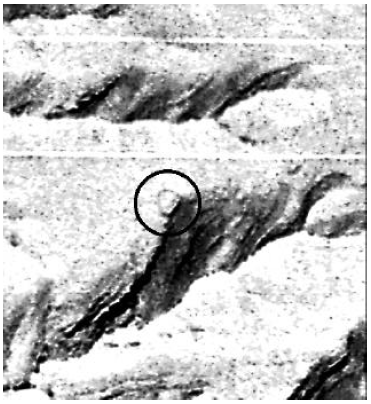
Figure 11: Sample satellite data illustrating the resolution presently available. Notice cars and even crosswalk markings on the street.

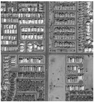
The order for two commercial satellite photos of the south side of Mt. Cilo, where IO3 was photographed in the 1960s, has now been accepted.[32] I hope to have modern, high resolution (1-meter) images of IO3 to share by the time the next issue of The Biblical Chronologist goes to press. Nothing is guaranteed at this point, however. There are a number of factors beyond our control which may yet hinder acquisition of suitable photos. These include cloud cover in the area when the satellite passes overhead, and snow cover on the ground, for example.

The major objective with these photos is to see if IO3 is still there on the side of Mount Cilo. If it is, we hope to learn more about its true nature—specifically, whether it is remains of the ark, or some other natural or man-made object. ◇

The Biblical Chronologist is a bimonthly subscription newsletter about Biblical chronology. It is written and edited by Gerald E. Aardsma, a Ph.D. scientist (nuclear physics) with special background in radioisotopic dating methods such as radiocarbon. The Biblical Chronologist has a threefold purpose:

  1. to encourage, enrich, and strengthen the faith of conservative Christians through instruction in Biblical chronology,

  2. to foster informed, up-to-date, scholarly research in this vital field within the conservative Christian community, and

  3. to communicate current developments and discoveries in Biblical chronology in an easily understood manner.

An introductory packet containing three sample issues and a subscription order form is available for $9.95 US regardless of destination address. Send check or money order in US funds and request the "Intro Pack."

The Biblical Chronologist (ISSN 1081-762X) is published six times a year by Aardsma Research & Publishing, 412 N Mulberry, Loda, IL 60948-9651.

Copyright © 2000 by Aardsma Research & Publishing. Photocopying or reproduction strictly prohibited without written permission from the publisher.

Footnotes

  1. ^  The days spent at Yeroham were Saturday, June 17, the morning of Sunday, June 18, and then Saturday through Tuesday, June 24–27. June 19–23 I attended the 17th International Radiocarbon Conference held a few kilometers outside of Jerusalem. (The talk I presented at the conference comprises the "Biblical Chronology 101" column this issue.)

  2. ^  Gerald E. Aardsma, "Yeroham—The True Mt. Sinai?" The Biblical Chronologist 1.6 (November/December 1995): 1–8.

  3. ^  Gerald E. Aardsma, A New Approach to the Chronology of Biblical History from Abraham to Samuel, 2nd ed. (Loda IL: Aardsma Research and Publishing, 1993).

  4. ^  Gerald E. Aardsma, "The Bamah of Moses at Mount Sinai" The Biblical Chronologist 6.3 (May/June 2000): 1–10.

  5. ^  See Numbers 33:3 and Exodus 19:1.

  6. ^  Gerald E. Aardsma, "The Route of the Exodus," The Biblical Chronologist 2.1 (January/February 1996): 1–9.

  7. ^  Exodus 17:8–13.

  8. ^  Exodus 19:1–3.

  9. ^  Exodus 19:1, NASB.

  10. ^  Exodus 19:2.

  11. ^  Exodus 12:37.

  12. ^  Exodus 17:1–7.

  13. ^  Gerald E. Aardsma, A New Approach to the Chronology of Biblical History from Abraham to Samuel, 2nd ed. (Loda IL: Aardsma Research and Publishing, 1993); Gerald E. Aardsma, "Chronology of the Bible: 3000–1000 B.C.," The Biblical Chronologist 1.3 (May/June 1995): 1–3.

  14. ^  Gerald E. Aardsma, A New Approach to the Chronology of Biblical History from Abraham to Samuel, 2nd ed. (Loda IL: Aardsma Research and Publishing, 1993); Gerald E. Aardsma, "The Chronology of Egypt in Relation to the Bible: 3000–1000 B.C.," The Biblical Chronologist 2.2 (March/April 1996): 1–9.

  15. ^  Gerald E. Aardsma, A New Approach to the Chronology of Biblical History from Abraham to Samuel, 2nd ed. (Loda IL: Aardsma Research and Publishing, 1993); Gerald E. Aardsma, "The Chronology of Palestine in Relation to the Bible: 3000–1000 B.C.," The Biblical Chronologist 1.4 (July/August 1995): 1–6.

  16. ^  Moshe Kochavi, "Mount Yeroham," The New Encyclopedia of Archaeological Excavations in the Holy Land, vol. 4, ed. Ephraim Stern (New York: Simon & Schuster, 1993), 1507.

  17. ^  E. D. Oren and Y. Yekutieli, "North Sinai During the MB I Period—Pastoral Nomadism and Sedentary Settlement," Eretz-Israel 21 (1990): 16. (English translation provided by Marganit Weinberger-Rotman.)

  18. ^  Alice Wonder, "Sinai," Wycliffe Bible Encyclopedia, vol. 2, ed. Charles F. Pfeiffer, Howard F. Vos, John Rea (Chicago: Moody Press, 1975), 1597.

  19. ^  Alice Wonder, "Sinai," Wycliffe Bible Encyclopedia, vol. 2, ed. Charles F. Pfeiffer, Howard F. Vos, John Rea (Chicago: Moody Press, 1975), 1597.

  20. ^  Ram Gophna, "The Intermediate Bronze Age," The Archaeology of Ancient Israel, ed. Amnon Ben-Tor (New Haven: Yale University Press, 1992), 135.

  21. ^  Emmanuel Anati, "Karkom, Mount," The New Encyclopaedia of Archaeological Excavations in the Holy Land, vol. 3 (New York: Simon & Schuster, 1993), 850–851.

  22. ^  Nelson Glueck, Rivers in the Desert: A History of the Negev, Evergreen Encyclopedia Volume 5, (New York: Grove Press, Inc, 1959), map following page 20.

  23. ^  Larry R. Williams, The Mount Sinai Myth (New York: Wynwood Press, 1990).

  24. ^  Gerald E. Aardsma, "Biblical Chronology 101," The Biblical Chronologist 2.2 (March/April 1996): 9–12.

  25. ^  Gerald E. Aardsma, "The Bamah of Moses at Mount Sinai" The Biblical Chronologist 6.3 (May/June 2000): 1–10.

  26. ^  Moshe Kochavi, "Yeroham, Mount," The New Encyclopedia of Archaeological Excavations in the Holy Land, vol. 4, ed. Ephraim Stern (New York: Simon & Schuster, 1993), 1507.

  27. ^  Numbers 10:29–32.

  28. ^  John Rea, "Kenite," Wycliffe Bible Encyclopedia, vol. 2, ed. Charles F. Pfeiffer, Howard F. Vos, John Rea (Chicago: Moody Press, 1975), 986.

  29. ^   The Archaeology of Ancient Israel, ed. Amnon Ben-Tor (New Haven: Yale University Press, 1992), plate 23.

  30. ^  Exodus 19:18.

  31. ^  For background on this research project see: Gerald E. Aardsma, "Radiocarbon Dating Noah's Flood," The Biblical Chronologist 3.6 (November/December 1997): 1–11, and Gerald E. Aardsma, "Radiocarbon Dating Noah's Flood – Part II" The Biblical Chronologist 6.2 (March/April 2000): 1–11.

  32. ^  See Gerald E. Aardsma, "Research in Progress," The Biblical Chronologist 5.3 (May/June 1999): 7–16 for background on this research project.


Volume 6, Number 5September/October 2000

Report on the Excursion to Mt. Yeroham – Part I

Last issue I explained how we know, from available Biblical, archaeological, topographical, and chronological evidences, that Mt. Yeroham in Israel is the Biblical Mt. Sinai.

After reading the last issue a friend wrote me asking about Galatians 4:25, which I had not discussed. This verse mentions (NASB), "Mount Sinai in Arabia…". It raises the question: "But is Mt. Yeroham in Arabia?"

I dealt with this question several years ago, but forgot to review it last issue. Here is the kernel of the answer from my previous discussion.[1]

Arabia, in New Testament times, included the Sinai Peninsula (where the traditional site of Mount Sinai is located) and the Negev of Israel (where I have suggested Mount Sinai is really located). (You can easily verify this using a Bible atlas or maps of the Mediterranean regions at the time of Paul found in many Bibles.)

This issue I move from a discussion of how we know Mt. Yeroham is the Biblical Mt. Sinai to a report on my recent excursion to Mt. Yeroham. My purpose in going to Mt. Yeroham was mainly to document the state of the site today, as I explained last issue. My purpose with the present article is to put what was found at Yeroham on public record.

Getting There: June 13–17

Philip (my cameraman) and I were scheduled to fly from Chicago to Tel Aviv on Tuesday, June 13. Unfortunately, a series of thunderstorms grounded air traffic, which caused our flight to be canceled.

Rescheduling turned out to be more difficult than usual. Many tourists were going to Israel to celebrate year 2000. There were almost no spare seats on airplanes headed for Israel.

We ended up flying out of Chicago two days later, on June 15, on a flight to Amsterdam. After a lengthy stopover in Amsterdam we arrived in Tel Aviv in the early morning hours of Saturday, June 17.

Saturday, June 17

We rented a car at the airport and headed south toward Be'er Sheva in the dark, and then on toward Yeroham. We only got lost once in Tel Aviv, and once in Be'er Sheva on the way.

We watched the sun rise above the eastern horizon, and the full moon sink below the western horizon as we neared the end of our journey, well to the south, in the parched Negev hill country.

Shortly after 6:00 a.m. we were viewing the true Mt. Sinai from the road for the first time. Yeroham is a low, sprawling mountain—hardly the sort of thing to titillate one's spiritual vanity. The glory of Sinai rests in what God did there four and a half thousand years ago, not in any intrinsic physical grandeur.

Our initial objective was to drive around the mountain, sticking to the main roads, to survey the area from all angles and find the best place to park our car for hiking up into the mountain. We were surprised to find an extensive, abandoned national park, incorporating the reservoir we had seen previously in satellite photos of the area (Figure 1), to the east of the mountain on the edge of the town of Yeroham.

Figure 1: Satellite photo of Mount Yeroham (right half of photo) and a small portion the Yeroham basin (left half of photo) where the Israelites' tent city was situated. The large dark object is a modern reservoir. The present summit is marked by "S", the bamah by "b", and the Midianite/Kenite dwellings by "m". North is toward the bottom in this view. [Photo taken September 29, 1971; available from U.S. Geological Survey EROS Data Center as DS1115-2300DF053.]

Figure 2: Firing zone sign outside the town of Yeroham.

Also unanticipated were signs on either side of the road, as soon as we had gone a few kilometers from the town of Yeroham, which read "FIRING ZONE ON BOTH SIDES". We soon realized that the whole area of which Mt. Sinai is a part is presently being used as a military training grounds. We began to be glad that we had arrived on a Sabbath, when everyone—military included—was taking the day off, allowing us to explore without incident or interruption.

Figure 3: The summit of Sinai from the plain to the east. The bamah hill is out of view to the right of this photo.

Figure 4: Blocked roads back into the park leading to the dam at the base of Mount Yeroham.

Figure 5: A good view of the bamah hill (right) and the Midianite/Kenite settlement hill (left) from the south-southeast, from our car on Route 204.

The best view of the mountain, we soon discovered, is from the east, where the Israelites camped. We found the best place to park was in the parking lot of the abandoned park. It would have saved us several miles of hiking to use the roads of the park to drive closer to the mountain. But these roads were all blocked off, and a policeman who drove into the area while we were there said—in very halting English—that it was okay for us to hike into the park, but we should not take our vehicle any further than the parking lot.

We explored the park on foot that morning, just finding our way around. The sky was completely clear, and the early morning temperature was pleasant.

By 8:00 a.m. it was already beginning to get hot. We drove on to Ben Gurion University of the Negev where we would be lodging. We intended to do some planning in our room that afternoon, for our major assault on the bamah early the next day, but we wound up falling asleep from sheer exhaustion instead.

Figure 6: The bamah hill (left) and Midianite/Kenite settlement hill (right) from the east, from the access road back to the dam.

Figure 7: The reservoir with the bamah hill centered in the background. Taken from the east.

We woke in the early evening, and drove to Dimona to get something to eat. We were good and hungry; we calculated that we hadn't eaten anything in nearly twenty-four hours by that point.

Sunday Morning, June 18

Sunday morning, June 18, was very productive. Our goal for the day was to ascend to the bamah—where Moses had erected an altar four and a half thousand years previously at the foot of Mount Sinai (Exodus 24:4)—and spend time there making observations, recording measurements, and taking photos.

Figure 8: The modern dam from the front.

Figure 9: View of the reservoir from the dam.

We rose at 5:00 a.m. and had a light breakfast of granola bars and dried fruits. We left our rented room around 5:30 a.m. and arrived at Yeroham near 6:00.

We left our car in the parking area at the entrance to the park and, equipped with knapsacks and several quarts of water each, began the hike through the park, around behind the dam, and up the steep hill to the bamah.

By 6:30, with frequent stops to photograph what we were seeing, we had arrived at the front of the dam.

The Bamah

Another forty-five minutes, after a strenuous climb up the steep side of the bamah hill, found us just outside the bamah wall, near the crest of the hill.

I had anticipated this moment for months. I climbed over the wall knowing that I was the first person in many, many centuries to set knowledgeable eyes on the interior of this holy place.

Figure 10: Dr. Aardsma ascending the hill to the bamah. The ground is covered with broken limestone and desert shrubs.

Figure 11: Taking a break from the climb, just below the bamah. Dr. Aardsma is sitting on a tumulus (ancient grave) made of piled stones.

Figure 12: Dr. Aardsma crossing the stone wall into the bamah.

Figure 13: The view to the north from inside the bamah.

Figure 14: The view from the bamah to the west.

The site had obviously suffered some considerable depredation over the four and a half thousand years it had stood exposed here. Substantial remnants of the stone wall surrounding the quarter-acre site still survived all around the perimeter. But no recognizable vestige of the original altar remained. Numerous large stones were scattered about within the bamah and also outside the walls. Many of these were doubtless part of the walls or the altar Moses had built there originally.

Figure 15: A view from the bamah out over the extensive plain to the east (into the early morning sun) where the Israelite tent city was situated.

Figure 16: Dr. Aardsma seated in the bamah with the Midianite hill in behind to the northwest.

Cupmarks

One of our major objectives in visiting the bamah was to document the layout and size of the twelve cupmarks the archaeologist Moshe Kochavi said were located there.[2] In this regard we were surprised and disappointed. We had expected to find twelve distinct cupmarks of roughly the same size arranged in a neat line or some other obvious pattern. In fact, we were only able to count twelve "cupmarks" by including everything which might possibly have been a cupmark, and those we did identify were not in a neat line or other pattern.

Figure 17: Dr. Aardsma inspecting the cupmarks in the limestone outcrop near the center of the bamah.

The twelve "cupmarks" we found were depressions in the limestone surface near the center of the bamah, near where the alter must originally have been situated. We numbered them from most to least distinct. (See Figures 18–20. Note that the coin, for scale, is one shekel in all cases; it is slightly smaller than a U.S. one cent coin, roughly 18 millimeters in diameter.) The first six were unambiguously cupmarks. The remaining six were depressions in the limestone surface of varying degrees of shallowness, some of which may have been due to natural causes.

Figure 18: Cupmarks 1–4.

Figure 19: Cupmarks 5–8.

Figure 20: Cupmarks 9–12.

These twelve "cupmarks" were found to be scattered around a line running roughly north and south. Thus they faced the plain where the Israelites' tent city had been situated.

The line around which the cupmarks were scattered was found to be several feet to the east of the north-south centerline of the bamah (i.e., displaced from center toward the plain by several feet). Cupmark #1 was the furthest to the south. It was forty feet from the stone wall on the south side of the bamah. Cupmark #3 was the furthest to the north. It was forty-three feet from the north wall, and almost fourteen feet from cupmark #1. Summarizing these observations we may say that the cupmarks were found to be roughly centered in the bamah, though slightly displaced toward the plain.

The idea that the original purpose of these cupmarks was to serve as the basins mentioned in Exodus 24:5–6, to receive half of the sacrificial blood, seems strengthened by this observed placement. But as this placement is dependant upon the proper identification of the cupmarks in each individual instance, and as proper identification of all cupmarks seems quite uncertain at this late date, as mentioned above, no guaranteed conclusion regarding their origin or purpose seems possible at present.

One thing which does seem certain is that we are not viewing these cupmarks as they would have appeared four and a half thousand years ago. The cupmarks are cut into a very soft limestone. Because rainwater is acidic it erodes limestone by slowly dissolving it. The bottoms of several of the cupmarks were found to be sunk significantly below the bowl-shaped walls of the cupmark. This is easily seen with cupmark #1, for example (Figure 18). It appears that at least the bottoms of some of these cupmarks have been dissolved significantly by rainwater.

But it is quite impossible for just the bottoms of the cupmarks to have experienced dissolution due to rainwater. The entire exposed surface of the limestone must have been subject to this same effect, though in lesser degree, through the millennia. Thus it seems likely that the entire surface of the limestone outcrop within the bamah has eroded appreciably since Moses' time.

In addition to this prediction of slow, uniform erosion of the entire limestone surface, we found evidence of very rapid present-day erosion in some places. Cupmark #1, for example, was in a block of limestone at the edge of the limestone outcrop containing all the cupmarks. One side of this block was obviously eroding very quickly (Figure 21). This section of the block was pure white in appearance, compared to the tans and grays of most of the limestone surface. Its surface was rough and uneven relative to the tan and gray surfaces. This white section did not appear to have been broken, but rather it appeared to have been eaten back into the rock by dissolution.

Figure 21: Cupmark #1 is on the left; the rapidly eroding limestone surface is on the right.

Figure 22: Dr. Aardsma walking across the center of the high place. Moses' altar probably stood just to Dr. Aardsma's left originally. This picture was taken from just inside the north wall of the bamah to show how the limestone floor rises in the center of the bamah.

Figure 23: A view of the modern reservoir from the bamah.

Figure 24: Another view from the bamah of the plain where the Israelites camped. A line of trees separates the plain from the foot of the bamah hill. These mark the wadi bed which runs along the base of the mountain on its east side. During the rainy season a stream would flow in this channel, filling the reservoir. It seems probable that this was "the brook that came down from the mountain" (Deuteronomy 9:21) which Moses threw the dust of the golden calf into, though one of the smaller wadis of the numerous ravines of the mountain is also possible.

This same phenomenon was seen with other rocks in the area, and was characteristic of numerous large, cave-like depressions in the sides of the ravines of the mountain. Clearly, the limestone which is native to the Yeroham/Sinai region can erode very quickly.

Figure 25: Closeup of a section of the wall surrounding the bamah. This is the interior, northeast section of the wall. It was in considerably better repair than most of the rest of the wall; it may have been restored by archaeologists in recent decades.

Figure 26: The modern reservoir to the east with a portion of the bamah wall in the foreground.

Figure 27: Dr. Aardsma standing in the "gate" in the wall on the southwest side of the bamah, looking further up the mountain.

These observations suggest that the limestone outcrop into which the cupmarks were cut by Moses has experienced significant alteration due to weathering in the past four and a half thousand years. They suggest it is unlikely that one will be able to accurately identify all of the cupmarks Moses cut into the limestone of the bamah floor originally. At the present time six cupmarks can still be unambiguously identified. It is doubtful that any of these would survive as recognizable cupmarks if left to the depredations of natural weathering for another four and a half thousand years (i.e., to the year A.D. 6500).

Ten Commandment Tablets

One of the questions I had hoped to be able to answer by my excursion to Yeroham was what type of rock the Ten Commandments were written on. This now seems completely clear. The whole region around Yeroham abounds with soft, white limestone. This native stone is obviously very suitable to the task. When I scraped at the white limestone of the rapidly-eroded surface near cupmark #1 with my pocket knife, I found it to be very soft—almost as soft as chalk. It is now evident how Moses could easily cut out two stone tablets (Exodus 34:1). It seems we may safely picture the Ten Commandments as written in the surface of relatively soft, pure white limestone tablets.

I had also hoped that we might be able to pinpoint where it was that the original Ten Commandment tablets were broken by Moses.[3] It would surely be a spectacular discovery if fragments of these original tablets "written by the finger of God"[4] could be found today. But such a discovery now seems essentially impossible. The limestone is soft, and easily eroded—not conducive to preservation in recognizable form over four and a half thousand years if left exposed to the elements. Additionally, there are many possible paths from the bamah down to the plain, making the route of Moses' descent on that occasion impossible to discern. Finally, construction of the modern reservoir has greatly perturbed the surface of the ground at the foot of the mountain. A search for fragments of the original Ten Commandment tablets now seems to me to be a futile, hopeless quest.

The Burning Bush

I was also curious to view the various sorts of bushes that grew on Sinai, because of the well-known Biblical account of the bush that burned when God first revealed Himself to Moses at Sinai.[5] We found three different types of bushes in the bamah (Figures 28–30). These were typical of the bushes in the region.

Figure 28: Dr. Aardsma surveying bush #1. This one had lots of what seemed to be green stems and no leaves.

Figure 29: Another larger bush. This one was more woody, and had tiny green leaves.

Figure 30: A third type of bush. This one grew low to the ground. It had dried leaves on new stems among many old stems, suggesting that it may sport new leaves only during the rainy season each year.

Midianite/Kenite Settlement

We had accomplished our major objectives at the bamah by 9:30 a.m. We needed to be back to our room before noon to check out. We would be driving to Jerusalem that afternoon to participate in the week-long 17th International Radiocarbon Conference.[6] We planned to return to Yeroham for a few more days following the conference.

Figure 31: Dr. Aardsma ascending the mountain west of the bamah.

Figure 32: A view of the bamah from the west.

Figure 33: Pottery shards we stumbled upon on our way to the Midianite/Kenite settlement. We found five pieces close together which appeared to have come from a single plate or other vessel. These were brick-red on the outside and brown on the inside.

It was hot beneath the glaring desert sun by the time we had finished our work at the bamah, with no hope of shade on the top of the hill and precious little breeze. We were pleased at having accomplished so much so quickly, and considered consolidating our gains and heading back out then and there. But we still had water in our water containers, and the Midianite/Kenite settlement was only one hill away. Ultimately we decided to have a brief look around there while we had the chance.

Figure 34: Another view of the bamah from the west.

Figure 35: The view to the east from just outside the Midianite/Kenite settlement to the southwest. The bamah is visible on the right. The plain before the mountain to the east fills most of the view beyond, with a bit of the reservoir to the left.

Figure 36: Surviving portions of stone walls of a Midianite/Kenite dwelling. Dr. Aardsma is standing within another dwelling further behind.

It was easy to get to the Midianite/Kenite settlement from the bamah. We followed the broadly rounded ridge which led west from the bamah (Figure 1). Once we had gotten beyond the upper end of the ravine which separates the bamah hill from the Midianite/Kenite settlement hill we turned north and then northeast, following the ridge line to the settlement.

A nice breeze had sprung up by the time we reached the Midianite/Kenite settlement. We admired their choice of settlement site in several ways. It was on top of a hill—a steep-sided ravine dropped away to the northeast—obviously easily defended. The view was grand in nearly all directions. And the site was well up above the plain, making best use of available breezes, as well as taking advantage of the natural cooling which comes with elevation. The only ones we pitied were those whose job it had been to make the trek up this steep hill with full water jugs each day.

We were in among the remains of the Midianite/Kenite dwellings by 10:05 a.m. These were built of large stones, laid close together without mortar. Some of the stones were small boulders, causing us to wonder how they had been moved into place. The dwellings were built close together, in no particular pattern, often sharing adjoining walls.

Figure 37: The wadi bed far below in the ravine to the northeast of the Midianite/Kenite settlement. The ravine drops off steeply, only a few feet from some of the dwellings. The Bible says of these people, "Your dwelling place is enduring, and your nest is set in the cliff" (Numbers 24:21, NASB).

Figure 38: A cupmark within one of the Midianite/Kenite dwellings. The archaeologists speculate that these may have been used for grinding grain.

Figure 39: A gray pottery shard found in one of the Midianite/Kenite dwellings.

Figure 40: Dr. Aardsma inspecting a pillar made of drum stones within one of the dwellings. Such pillars were used to support the roofs.

Figure 41: A pillar stone found within one of the dwellings.

Figure 42: A parting view (zoomed in) of the bamah hill from the Midianite settlement.

Back Out

We headed back out toward our car just before 11:00 a.m. We would be late checking out of our room—which did, in fact, catch us a scolding. We had meant to leave earlier, but time devalues when you poke about in four thousand five hundred year old dwellings where men and women once worked and children played—especially when you know from the Bible who those men and women were and why they settled there on that hill for a time.

Our water was gone before we were halfway back. And the car was an oven more fierce than the desert by the time we reached it. But our spirits were high as we drove the thirty minutes back to Ben Gurion University of the Negev. The weeks of planning, the large expense, the canceled flights, the lost sleep, the missed meals, the time away from our families, had all been worth it. We had accomplished more in a single morning than we had dared hope we might accomplish in a week. We had walked where Moses had walked. We had climbed the hill he had climbed beneath the burning desert sun. We had been the first in many, many centuries to set knowledgeable eyes on the bamah where he had constructed an altar four and a half thousand years ago. We had visited where his Midianite/Kenite relatives had lived during the Israelites' yearlong stay at Sinai. And all of this we had captured on digital video, documenting the present state of the sight and enabling us to share what we had learned and experienced with others.

Our work at Yeroham was not yet complete, of course. We had yet to ascend to the summit of the mountain, to learn what the area looked like where God had descended in fire.[7] And we had yet to explore the plain where the Israelites had camped. But we would soon be back, to experience, learn, and document more. ◇

Research in Progress

Ark Search

Modern Satellite Photos of IO3

Earlier this year we placed an order for two commercial satellite photos of the southeast side of Mt. Cilo, where IO3 was photographed in the 1960's (Figure 43).[8] These were to be taken at different angles and at different times, late in the summer to minimize snow cover.

Figure 43: 1960's photo of IO3. Is this Noah's ark?

The images would be in digital format (11-bit GeoTiff) on a CD. They could only be viewed via computer.

Unfortunately, the 11-bit GeoTiff format is not recognized by most mass-market programs designed to view and manipulate digital images. Many days were spent in preparation for receipt of our first 11-bit GeoTiff image, to guarantee that we would be able to get the image off the CD and onto the computer where we could look at it. This included obtaining a sample 11-bit GeoTiff image (a portion of which was shown last issue) to test our image-reading software.

I received the CD containing our first modern digital image of Mount Cilo on September 19. Despite our careful preparations this produced only error messages when we tried to read it from the CD into the computer.

Fortunately my eldest (college-age) son, Mark, was available to help. He is an accomplished C++ programmer. He spent some hours doctoring the software. Later that evening I had a hardcopy of our first modern image of Cilo in my hands.

It was immediately clear that we had a cloud-free image of the area, the focus was good, and illumination was excellent. There appeared to be more snow everywhere than we would like. Beyond that many more hours were required to figure out where IO3 should be—the image was taken from a very different perspective than previously. The plan was to zoom in (digitally) on the part of the image where IO3 should be, to see what, if anything, was there.

As it turned out the place where IO3 should be was out of view behind the mountain. The ground coordinates of the photo were those we had specified, but the satellite had taken the shot from north of Mount Cilo. This gave us a spectacular view of the whole north side of the mountain, but meant that the southeast side, where IO3 is situated in earlier (1960's) photos, was out of sight behind the mountain.

We are presently attempting to exchange this photo for one taken when the satellite was more to the south in hopes of learning more about the nature and location of IO3 at the present time. We are also expecting to receive another satellite image, from our second order, sometime in the next few weeks.

Ground Mission to IO3

It has been clear from the beginning that the most direct way to determine whether IO3 is the ark is to hike into the area, climb Mount Cilo, and take a look.

While this is the most direct approach, it is not the easiest, most economical, or safest one. The area is a remote one in Turkey. The mountains are high and jagged with scree-covered slopes to the south. Because of the altitude the region is under snow much of the year. There are several permanent glaciers in the area on the north side of the mountain range.

Despite these difficulties Mr. Tom Godfrey, one member of the ark project team with previous climbing experience, determined to attempt a solo hike into IO3 this summer. Following months of preparation, Tom flew to Turkey in September. He was turned back by local authorities, however, and not allowed to climb, despite the fact that he had obtained permission to climb in Turkey before leaving the U.S.

Local inhabitants report danger due to wolves and bears in the mountains. The political situation is not good in the region, with tensions between the Turks and the Kurds. And one local resident reported danger due to land mines on trails in the mountains.

Tom's experience underscores the importance of the modern satellite photos. ◇

The Biblical Chronologist is a bimonthly subscription newsletter about Biblical chronology. It is written and edited by Gerald E. Aardsma, a Ph.D. scientist (nuclear physics) with special background in radioisotopic dating methods such as radiocarbon. The Biblical Chronologist has a threefold purpose:

  1. to encourage, enrich, and strengthen the faith of conservative Christians through instruction in Biblical chronology,

  2. to foster informed, up-to-date, scholarly research in this vital field within the conservative Christian community, and

  3. to communicate current developments and discoveries in Biblical chronology in an easily understood manner.

An introductory packet containing three sample issues and a subscription order form is available for $9.95 US regardless of destination address. Send check or money order in US funds and request the "Intro Pack."

The Biblical Chronologist (ISSN 1081-762X) is published six times a year by Aardsma Research & Publishing, 412 N Mulberry, Loda, IL 60948-9651.

Copyright © 2000 by Aardsma Research & Publishing. Photocopying or reproduction strictly prohibited without written permission from the publisher.

Footnotes

  1. ^  Gerald E. Aardsma, "Biblical Chronology 101," The Biblical Chronologist 2.2 (March/April 1996): 9–12.

  2. ^  Moshe Kochavi and Rudolf Cohen, "Mount Yeroham," The New Encyclopedia of Archaeological Excavations in the Holy Land, vol. 4, ed. Ephraim Stern (New York: Simon & Schuster, 1993), 1506–1507.

  3. ^  Exodus 32:19.

  4. ^  Exodus 31:18.

  5. ^  Exodus 3:1–6.

  6. ^  The talk I presented at the conference was transcribed last issue in the "Biblical Chronology 101" column.

  7. ^  Exodus 19:18.

  8. ^  See Gerald E. Aardsma, "Research in Progress," The Biblical Chronologist 5.3 (May/June 1999): 7–16 for background on this research project.


Volume 6, Number 6November/December 2000

Report on the Excursion to Mt. Yeroham – Part II

This past June I had the privilege of exploring Mount Yeroham, the Biblical Mount Sinai.[1] Last issue I shared results from my investigation of the bamah (high place) built by Moses at the foot of the mountain four and a half thousand years ago,[2] and my visit to the archaeological remains of stone dwellings Moses' Midianite in-laws built on another hill at the foot of Mount Yeroham.[3]

My investigation of Yeroham was put on hold for a week while I attended the 17th International Radiocarbon Conference near Jerusalem, listening to scientists from around the world presenting results of their research, and presenting a paper myself on new radiocarbon dates on the Cave of the Treasure mat obtained as one of the research efforts of The Biblical Chronologist.[4]

The present article resumes the narrative back at Yeroham after the conference. It's purpose, as with the previous article, is to document the state of Yeroham/Sinai today, and to put on public record what I found there.

Friday, June 23

The final sessions of the 17th International Radiocarbon Conference had ended by noon on Friday, June 23. After lunch my cameraman, Philip, and I began the several hour drive from Jerusalem back to Yeroham. When we were situated in our lodging at the Ben Gurian University of the Negev once again I began to plan our next day's hike.

My goal this time was not the archaeological remains at the foot of Mount Yeroham/Sinai—i.e., the bamah and the Midianite/Kenite settlement—but rather the mountain itself. I was especially keen to visit the summit. The Bible records that "the Lord came down on Mount Sinai, to the top of the mountain; and the Lord called Moses to the top of the mountain, and Moses went up".[5] I wanted to see this place where Moses had met with God.

Figure 1: Pottery shard found on the way up the mountain, in an area containing many tumuli.

Figure 2: A desert millipede. It is a lustrous blue-black, and quite large, as my pen illustrates.

Figure 3: Snails in a desert shrub in the wadi next to the bamah hill. There were lots of these in the shrubs, and many shells of dead ones on the ground in places.

Figure 4: Sunrise over the Yeroham/Sinai plain and reservoir.

Figure 5: Dr. Aardsma nearing the bamah.

Figure 6: Looking back toward the reservoir, into the morning sun, from the bamah.

Figure 7: Dr. Aardsma standing outside the north wall of the bamah.

I suppose there are many reasons why someone might wish to visit the summit of Sinai. My reason was probably somewhat unusual. I was interested in the possibility Sinai presents of finding some answers to some difficult scientific and theological questions. The natural and the supernatural intersected at Sinai in an unusual way four and a half thousand years ago. We are unable to study supernatural processes directly in the science laboratory because they are intrinsically nonreproducible. As a result our ignorance of them is profound. Sinai offers a rare opportunity to study the intersection of the natural and the supernatural—to probe the aftermath of a miracle within the physical creation. The Bible records, for example, that "the mountain burned with fire to the very heart of the heavens".[6] Would we find evidence of this burning at the summit? And if we did, would the evidence be explainable in terms of some natural phenomenon, or would we find an effect (i.e., evidence of highly elevated temperatures) with no apparent natural cause?

Many of the phenomena associated with God's presence on Mount Sinai seem to coincide with what one might naturally expect of a volcano. The "consuming fire on the mountain top", the "thunder and lightning flashes and thick cloud upon the mountain", the "very loud trumpet sound" (this can result from pressurized gases escaping from the earth through a narrow vent), the "smoke" which "ascended like the smoke of a furnace", and the earthquake ("the whole mountain quaked violently") are all readily associated with volcanic eruptions.[7] This leads to the question: "Did God use a 'natural' volcanic event as the backdrop to His visit on Sinai?" Which leads to the further question: "Is Mount Sinai a volcanic mountain?"

Figure 8: Part of a topographical map with shaded contours showing the crater-like structure of whose rim Sinai is a part. The plain where the Israelites camped is toward the right (east).

As part of my preparations for the trip to Yeroham/Sinai I had scanned a topographical map into my computer, and then colored in the various contour elevations. I was surprised to find a clear crater-like shape emerge from this exercise (Figure 8). The present-day summit of Sinai is part of the "rim" of this "crater".

Figure 9: More desert critters. Philip described these ants as "huge", which they were.

Figure 10: View of the bamah from further up the side of the mountain.

Figure 11: Large stones of a single tumulus on the side of the mountain.

Figure 12: Dr. Aardsma squatting inside the burial chamber of an excavated tumulus.

Figure 13: Satellite photo showing our path from the bamah (b) to the summit (s).

Figure 14: Nearing the summit.

This obviously lent some support to the idea that Yeroham/Sinai might be of volcanic origin. But it was far from a guarantee. Crater-like features can result in other ways. And also on the other side of the ledger we should note that Exodus 19:18 is not very supportive of the idea that Mount Sinai was naturally volcanic. It says [NASB, my emphasis]: "Now Mount Sinai was all in smoke because the Lord descended upon it in fire". This seems to stipulate that God's presence was the direct cause of these volcanic-like phenomena at Sinai.

We obviously needed to go look at the crater to learn what we could of its origin—to see what story its rocks might tell. Our effort would be amateur only—I am a chronologist, not a geologist, and Philip is not a geologist either. But there is much that even amateurs may learn in the field, and we hoped to record much of what we saw on video for professional appraisal at a later date.

Figure 15: Looking up the gentle slope toward the summit.

Having visited Yeroham briefly before the radiocarbon conference I knew that the mountain was predominantly limestone. Limestone is a sedimentary rock, not an igneous rock. This led to the question, "What sort of volcano does one get in limestone?"

Fortunately, I was able to talk to a professional geologist, J.F. Shroder, Jr. of the University of Nebraska at Omaha, about this during the week of the radiocarbon conference. He said that yes, one can get volcanoes through limestone strata and that such volcanoes can produce a very fast flowing lava. When I showed him my colored topographical map he said that the crater shape might be indicative of volcanic activity or it might be just an erosional feature. When I asked him what we should look for at the mountain to try to tell for sure whether this crater was due to volcanism or erosion he said we should look for evidence that the limestone strata around the crater had been blistered upward from the pressure of magma forcing its way to the surface. This was all very helpful.

Exploration of the crater and its strata would require about a ten mile hike in, and another ten mile hike back. Since we planned to photograph everything as we hiked, we would not be moving along very quickly. We were obviously in for a full day.

Figure 16: Part of the mountain just east of the summit.

Figure 17: Looking across the ravine to the summit of Yeroham/Sinai, scarred by military roads.

Figure 18: Our first view of the crater.

Figure 19: An example of the splattered veneer covering many of the limestone rocks north of the summit. The veneer was brown; much of it is covered by lichen in this photo.

Figure 20: View from the summit to the west. The line of rocks in the close foreground marks the near crater rim. All else is a considerable distance from the camera. The hills in the background are about two kilometers away, coming down inside the far rim of the crater.

Figure 21: Dr. Aardsma heading north along the crater rim away from the summit.

Figure 22: A piece of the veneer showing some clear laminar structure. This was rare.

We knew from our previous hike to the bamah and the Midianite settlement that the exertion of climbing up and down steep ravines beneath the desert sun was a reality to be taken seriously. We would take four quarts of water each. Water is heavy to carry up and down desert mountains; one would like to have along a little extra, but not too much. We figured four quarts would be about right with modest rationing. We also took along a small supply of granola bars, raisins, and pretzels. We didn't plan on eating much until we got back out since food consumption increases the need for water. We planned to watch the time closely and begin the hike back out at noon, even if we had not accomplished all of our goals, to make sure we got back out before dark.

Saturday, June 24

We rose just after 4:00 a.m. the next morning. By 5:30 a.m. we had parked our car and begun our hike toward the mountain. The early morning air was full of humidity, and there was an unexpected cloud cover.

By 6:10 a.m. we were in the ravine between the bamah and the Midianite settlement hills. The heat and humidity were making hiking a sweaty affair. We took a short break to watch the desert critter shown in Figure 2 mosey its way along the desert floor, and to photograph the snails shown in Figure 3.

Looking back down the wadi we could see the sunrise reflected in the reservoir (Figure 4).

By 6:30 we had attained the bamah. We didn't linger there. The cloud cover was beginning to break up and the intermittent full sun was already hot. We pressed on toward the summit.

We followed the gentle slope of the mountain from the bamah up toward the summit along an arm of the mountain (Figure 13). The wadi ravines provided natural boundaries on either side of our path.

The walk to the summit from the bamah was leisurely and pleasant. It contrasted with the climb to the bamah from the plain, which is short and steep. It was easy to see how Moses could make this climb to the summit repeatedly as he did, at age eighty, without suffering heart failure in the process.

We were treated to scenic, panoramic views as we walked, especially back toward the plain to the southeast (Figure 10). The sun was often behind a haze, greatly increasing our comfort.

Eventually we came to the end of the arm of the mountain we had been following. A broad shallow ravine was all that separated us from the summit. As we looked across the ravine we were surprised to see several military roads cut into the side of the mountain only a few hundred feet down from the summit (Figure 17). I had thought that the summit would seldom if ever have been visited since Moses' time. The sight of these bulldozed dirt roads exploded that mistaken notion and dashed my hopes of a well-preserved summit.

We crossed the ravine and, after we had climbed to the top on the other side, found ourselves at the edge of the crater, still somewhat below the summit. The rim of the crater at this location, just a short distance to the north of the summit, was strewn with rounded, pitted, limestone rocks and boulders. Many of these wore a broken veneer of some other sort of brownish rock, which gave no limestone reaction when tested with hydrochloric acid. We had not seen this sort of veneer anywhere else. It was mainly on the side of the rocks facing the crater—it looked like it might have been spattered onto them from the direction of the crater. We spent a lot of time photographing and studying these rocks, trying to understand what this veneer meant. But we were unable to reach any definite conclusion that day, and I am still uncertain what, if anything, the veneer may have to do with the volcanic-like phenomena which accompanied God's descent on Sinai.

Figure 23: More veneered limestone.

Figure 24: Dr. Aardsma standing on the edge of a precipice on the north rim of the crater. In behind is the crater as it appears from the north rim looking south.

Figure 25: The west wall of the breakout as seen from the east side.

We reached the summit at 8:15 a.m. We found that the military had indeed been there before us. The rocks had obviously been moved around significantly, and there were remnants of wire running across the ground. All remaining hopes of viewing the summit as Moses had left it were dashed at this point.

In hindsight it is clear that the use of this area as a military training ground guaranteed that the summit would be significantly disturbed. The combat advantage offered by even just the clear view in all directions was sufficient to ensure this.

The air was comfortably cool, with a kindly breeze blowing. The view was very nice, especially to the east. For some reason we failed to photograph this. The view to the west looked out over numerous sandy-white hills running down into the crater (Figure 20). To the northwest the view plunged steeply down the inside crater wall at our feet and across its depths to the breakout in the north wall where the wadi which drained the crater transected the rim. We took some time to check our bearings against our map, using a pocket compass, and confirmed that we were, indeed, at the summit of Mount Yeroham.

We snacked a little on pretzels and discussed the next leg of our hike. Our next objective was to view the strata on the west side of the breakout from its east side. Our purpose was to try to determine whether the limestone strata gave any indication of having been blistered upward, as we had been advised by our geologist friend. This would take us northward, along the east rim.

We encountered more partially veneered limestone as we started out along the rim. If one imagined the veneer being splattered onto the limestone rocks through the air, then its source seemed to be back in the general direction of the summit. As we continued to walk along the rim away from the summit the veneer gave out and was eventually no longer seen.

We also encountered large areas strewn with chert flakes, not too far north from the summit, as if at some point in the past someone had spent a lot of time working flint tools in the area. These flakes possibly predate even Moses' ancient presence on the mountain.

We reached the east wall of the breakout around 10:45 a.m. The strata on the west wall sloped gently upward toward the south (Figure 25), and thus toward the crater, but this seemed to be a general feature of the entire region rather than due to any local blistering. Overall, the strata which were visible from the rim of the crater did not appear to support the idea of blistering, and thus did not seem to support a volcanic origin for the crater.

Figure 26: Looking back up into the crater from the east side of the breakout.

Figure 27: Dr. Aardsma standing inside one of the caves.

Figure 28: Another cave.

Our next objective was to descend the crater wall into the bottom of the crater itself. We wanted to learn what types of rock would be found at the bottom. We would be looking especially for any igneous rocks in this otherwise clearly sedimentary geological landscape. After a short rest, we began the steep descent.

Figure 29: The view from inside one of the caves, looking far below to the wadi bed in the crater floor, where we are headed.

Figure 30: View of the crater wall from inside the same cave.

Figure 31: Dr. Aardsma outside the caves, spying out the best route down into the crater.

We hadn't gone very far, however, before we noticed a group of shallow caves below the rim only a few hundred feet from where we had been standing. We had seen many such caves at a distance in the various ravines of the mountain. We were interested in them because of the Biblical record of Elijah's flight from Jezebel.[8] From that record we learn that Elijah fled to Horeb (i.e., Sinai) where he stayed for a time in a cave.

When I had been preparing to travel to Mount Yeroham I had wondered whether I might be able to identify the cave in which Elijah had stayed. It had become clear, from our earliest closeup encounter with the mountain, that there were plenty of caves to choose from—too many, in fact, to allow an easy identification of which one Elijah might have used.

But this was obviously a good opportunity to take a close look at a few of these caves to get a feel for how suitable they might have been to Elijah's purpose.

Though they varied much in size, all were fairly shallow—they did not extend back into the mountain any great depth. They appeared to have resulted from large blocks of limestone breaking out of the steep face of the crater wall or from rapid erosion of soft spots in the limestone. It was easy to see how they could function as comfortable shelters in time of need. Judging from droppings on the floor, some of them were presently in use by local desert wildlife for just that purpose.

Figure 32: Dr. Aardsma on his way down.

We were well into the final hour before noon by the time we had finished exploring and photographing the caves. Other than the splotchy veneer on the rocks near the summit everything we had seen to this point seemed to support only a sedimentary origin for the rocks of this mountain—we had seen nothing in obvious support of any volcanic activity at any time in the past. I was eager to get to the bottom of the crater to see what additional light might be shed on all of this. It would only take a single basaltic rock in the washout gravels of the wadi which cut its way across the crater floor to begin to turn the tables.

I surveyed the crater wall beneath the caves for the best way down. Some routes were obviously too steep. Having picked what seemed to be the best alternative, I started to zig-zag down through the loose limestone debris, leaning into the crater wall as I went. ◇

Research in Progress

Ark Search

Figure 33: 1960's photo of IO3. Is this Noah's ark?

I am disappointed to have to report that no new satellite photos have been obtained from Space Imaging, the commercial satellite company, since last issue. As it is now well past the time of year when reasonably snow-free coverage can be obtained in the Mount Cilo region, the earliest we can now hope for obtaining modern satellite images of IO3 is late next summer.

The reason given for Space Imaging's failure to obtain the images this past summer/fall is the huge consumer demand for this new technology which has sprung up since the commercial satellite came into service last year. (Supply and demand has driven the cost of new orders up by a factor of three compared to the cost when we placed our order.) The Biblical Chronologist order is not a routine one, being more demanding of camera positioning, time of image capture, and other factors than most orders. In addition, it is a small order compared to many others (though not small to us!). As a result, it does not appear to have had as high priority at Space Imaging as we might have wished. We are hoping that things may have calmed down in this industry sufficiently by next summer to yield a more satisfactory result.


I would like to extend a special word of thanks this issue to Basil Finnegan for the many hours he has spent of his own time on this modern satellite images project. Basil is a member of the ark search project team. He is The Biblical Chronologist interface to the commercial satellite world. When we get the images we are after it will be largely due to Basil's patient, persistent efforts. ◇

The Biblical Chronologist is a bimonthly subscription newsletter about Biblical chronology. It is written and edited by Gerald E. Aardsma, a Ph.D. scientist (nuclear physics) with special background in radioisotopic dating methods such as radiocarbon. The Biblical Chronologist has a threefold purpose:

  1. to encourage, enrich, and strengthen the faith of conservative Christians through instruction in Biblical chronology,

  2. to foster informed, up-to-date, scholarly research in this vital field within the conservative Christian community, and

  3. to communicate current developments and discoveries in Biblical chronology in an easily understood manner.

An introductory packet containing three sample issues and a subscription order form is available for $9.95 US regardless of destination address. Send check or money order in US funds and request the "Intro Pack."

The Biblical Chronologist (ISSN 1081-762X) is published six times a year by Aardsma Research & Publishing, 412 N Mulberry, Loda, IL 60948-9651.

Copyright © 2000 by Aardsma Research & Publishing. Photocopying or reproduction strictly prohibited without written permission from the publisher.

Footnotes

  1. ^  Gerald E. Aardsma, "Yeroham: the True Mount Sinai" The Biblical Chronologist 6.4 (July/August 2000): 1–11.

  2. ^  Gerald E. Aardsma, "The Bamah of Moses at Mount Sinai" The Biblical Chronologist 6.3 (May/June 2000): 1–10.

  3. ^  Gerald E. Aardsma, "Report on the Excursion to Mt. Yeroham – Part I" The Biblical Chronologist 6.5 (September/October 2000): 1–13.

  4. ^  Gerald E. Aardsma, "Radiocarbon Dating Noah's Flood – Part II" The Biblical Chronologist 6.2 (March/April 2000): 1–11.

  5. ^  Exodus 19:20, NASB.

  6. ^  Deuteronomy 4:11, NASB.

  7. ^  Exodus 19:16–19; 24:16–17, NASB.

  8. ^  1 Kings 19:1–13.


  Copyright © 2024 Aardsma Research & Publishing. All rights reserved.